

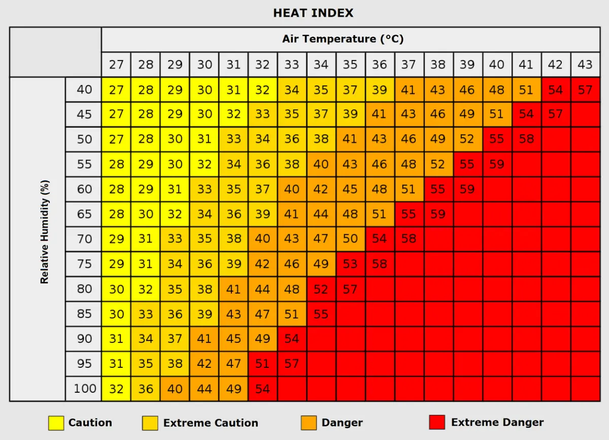
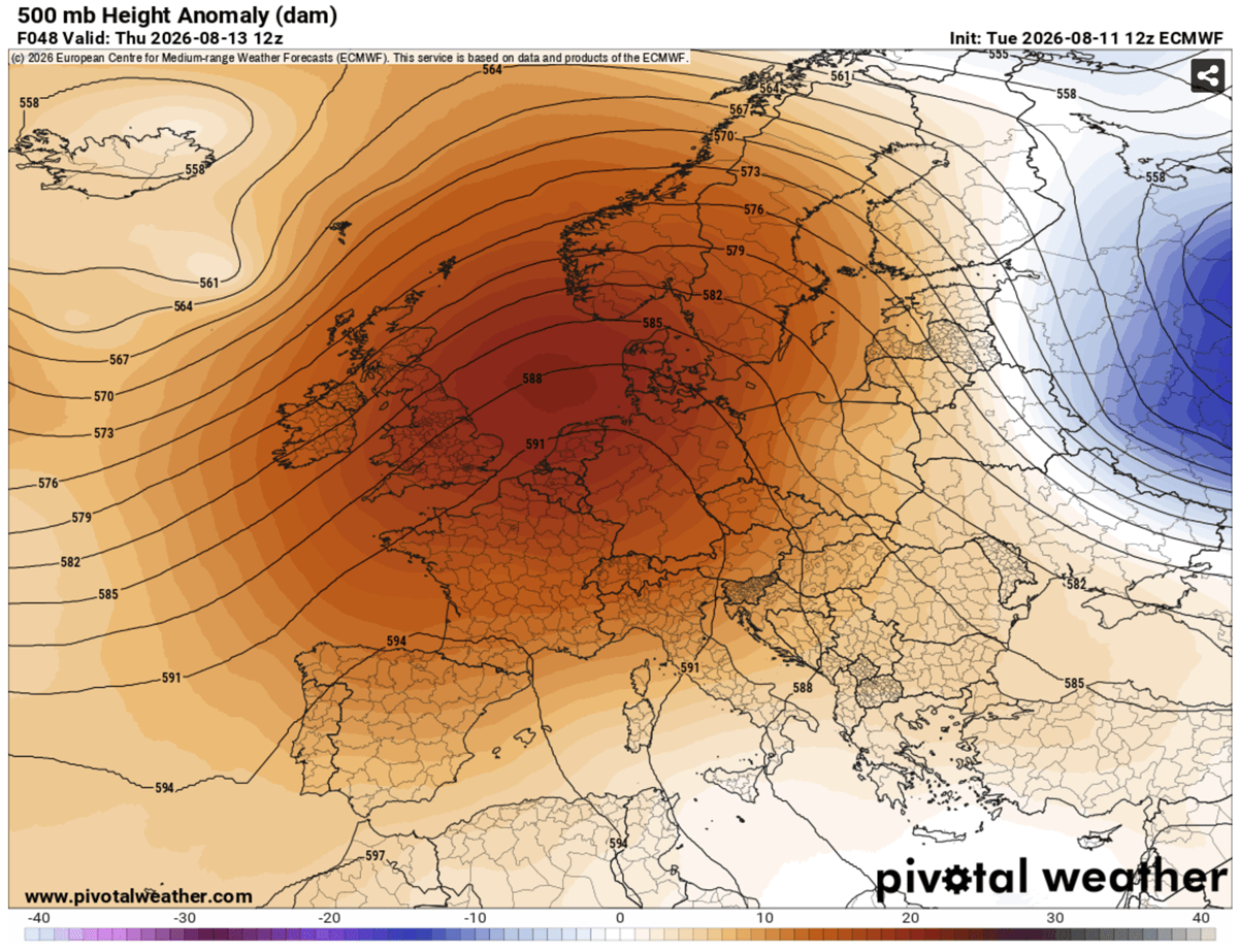
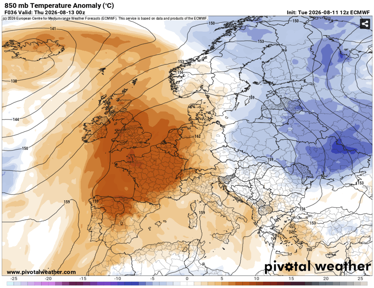
EUROPE — As mid-August sets in, continental Europe finds itself gripped by the season’s fifth major Heat Dome. Anchored by a high-amplitude upper-level ridge parked squarely over the heart of the continent, this persistent atmospheric blocking pattern is driving widespread afternoon temperatures past the 40°C threshold. Driven by a powerful northward warm surge, upper-air thermal anomalies have climbed into the 99th percentile, triggering severe excessive heat warnings across France, the United Kingdom, Italy, Central Europe, and the Balkan Peninsula.
The atmospheric engine behind this thermal wave is an exceptionally stubborn high-pressure system. As sinking air adiabatically compresses and warms the lower troposphere, peak surface temperatures across low-lying basins and plains are forecast to reach 40°C to 43°C. Coupled with dry continental winds that keep humidity low and rapidly deplete soil moisture, the region faces compounding environmental and physiological strains that show little sign of immediate relief.

Chronology of the Event: From Western Surge to Central Migration
The evolution of this atmospheric anomaly follows a distinct trajectory across Western and Central Europe, shifting eastward as the week progresses.
Mid-Week: The Western European Peak
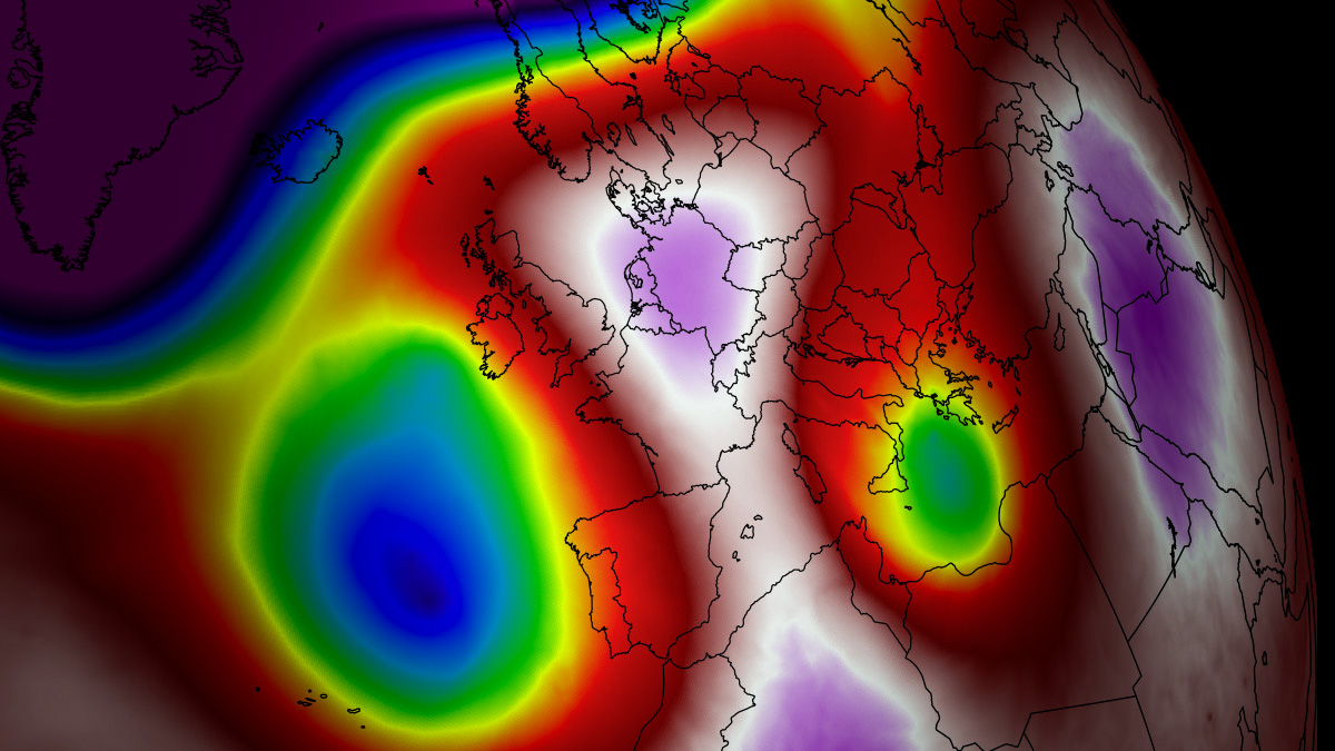
The synoptic setup began solidifying at the start of the week, with a deep trough over the North Atlantic pumping a robust warm plume far north across Western Europe. By Wednesday and Thursday, the core of the heat dome established itself directly over northern France, the English Channel, and the UK.
During this initial window, southern and central England experienced a short but intense spike, with temperatures climbing into the 36–39°C range on Thursday. Simultaneously, France bore the brunt of the low-level thermal compression, recording maximums between 40°C and 43°C over western, central, and southwestern regions. Across the Iberian Peninsula, heat-prone valleys in southern Spain and the Ebro Valley soared to 42–44°C, while south-central Portugal hovered near 40°C.
The Weekend Shift: Central Europe and the Balkans
By Saturday, the upper-level wave over the Atlantic is projected to emerge into Western Europe while weakening, causing the heat dome to elongate and shift eastward. This migration redirects the extreme heat into Germany, the Benelux nations, western Poland, the Czech Republic, and the Alpine region.
Friday marks the hottest day for Belgium, Luxembourg, and the southern Netherlands, with readings touching 36–40°C. Over the weekend, the heat expands further into Denmark, southern Sweden, Italy, and the northern Balkans. Lowlands in the Po Valley, Tuscany, eastern Croatia, Hungary, and northern Serbia are expected to challenge the 40°C mark once again. Relief is anticipated to arrive from west to east late in the weekend and into the following week as a maritime air mass from an Atlantic low gradually displaces the stagnant continental ridge.
Atmospheric Dynamics: Understanding the Heat Dome Phenomenon
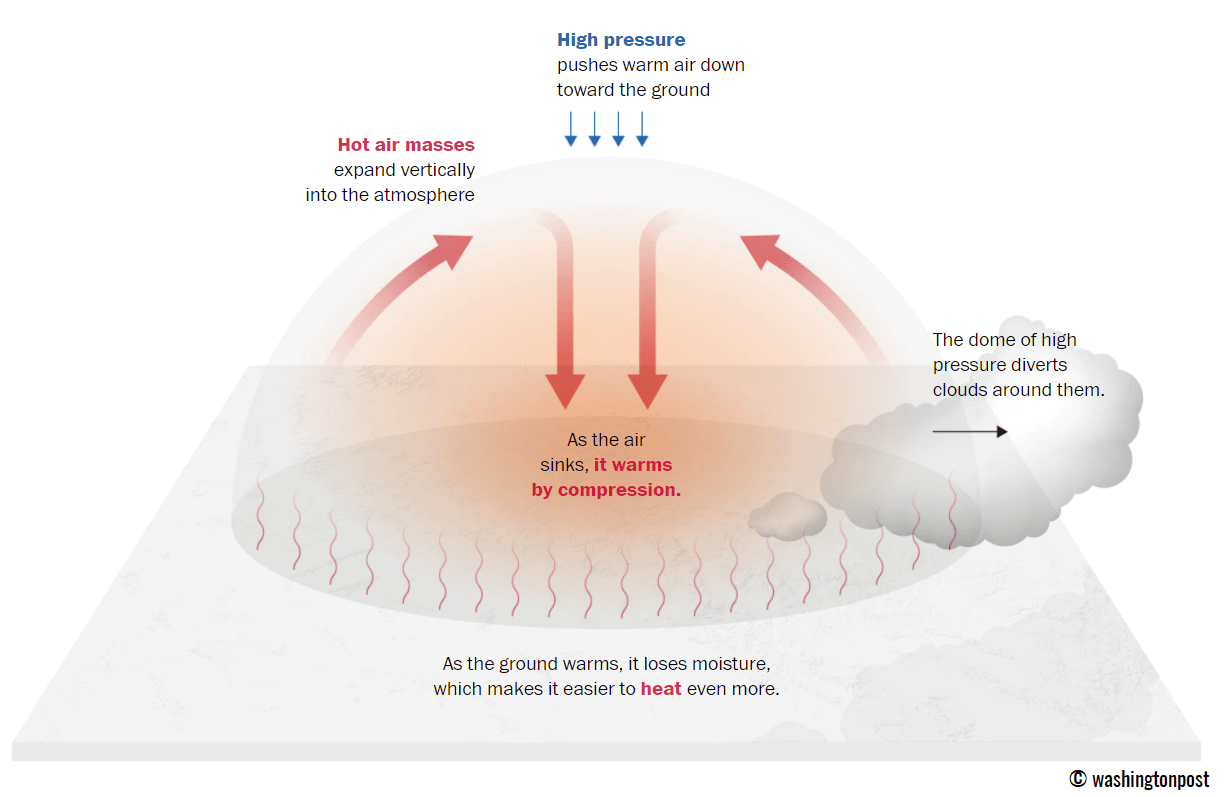
Meteorologically, a "Heat Dome" acts as a literal lid on a pot. When a broad, high-pressure air mass parks over a large continental area for an extended period, it traps warm air at all levels underneath it.
As air descends within the high-pressure system, it undergoes adiabatic compression—meaning it is squeezed and heated as atmospheric pressure increases closer to the ground. This process prevents the formation of clouds, allowing maximum solar radiation to bake the surface. The resulting lack of cloud cover and persistent sinking air create a self-reinforcing feedback loop: dry soils absorb more solar energy rather than using it to evaporate moisture, further superheating the lowest layers of the troposphere.
Supporting Data and Meteorological Metrics
The severity of this mid-August event is underlined by striking statistical anomalies:
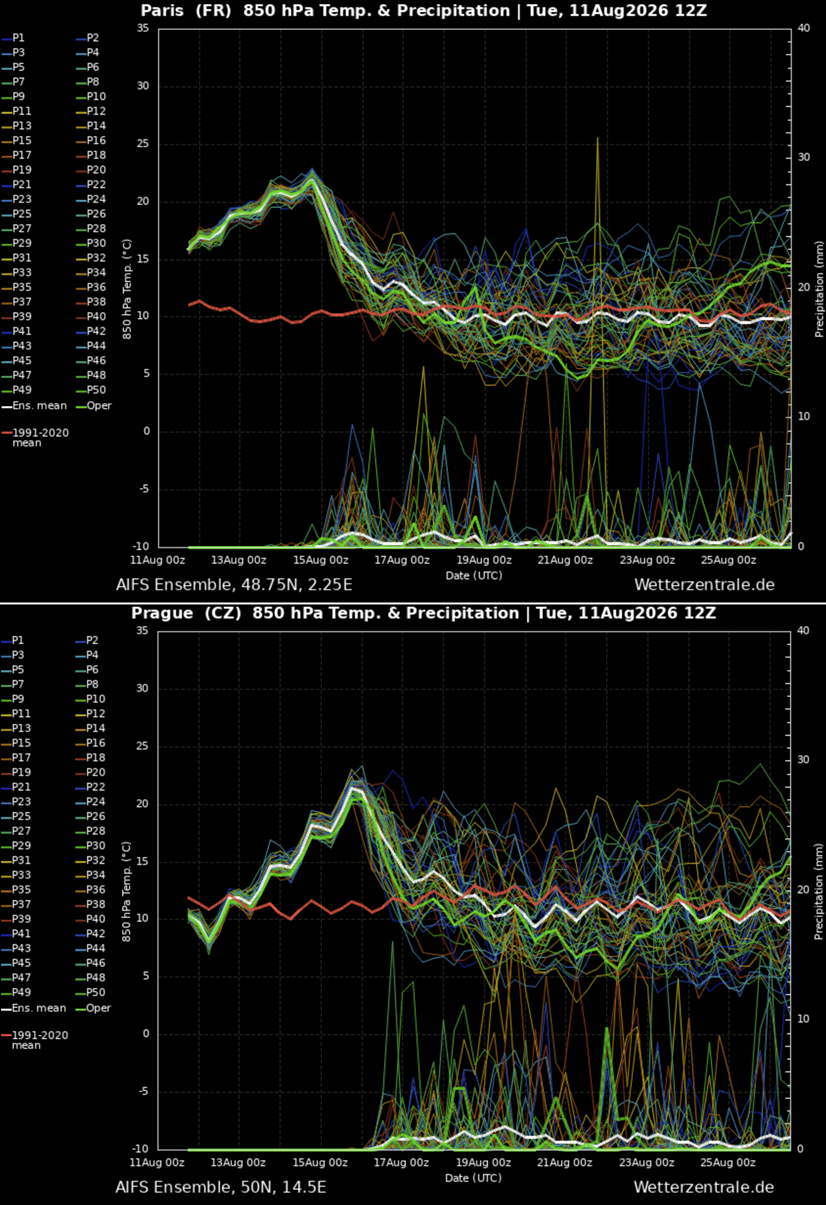
- Thermal Anomalies: Upper-air thermal anomalies at the 850 hPa level are tracking in the 99th percentile, sitting 12°C to 16°C above long-term historical averages for mid-August.
- Surface Temperature Extremes:
- Spain and Portugal: 42°C to 44°C in southern river valleys.
- France: 40°C to 43°C across central and southwestern departments.
- United Kingdom: 36°C to 39°C across central and southern England.
- Central Europe (Germany, Benelux): 36°C to 40°C.
- Nocturnal Minimums ("Tropical Nights"): Overnight low temperatures are refusing to drop below 22°C to 26°C in major urban corridors, denying human bodies a vital physiological cooldown window.
Societal Implications: Health Risks and Grid Pressures
The combination of extreme daytime highs and suffocating tropical nights presents severe risks to public health and critical infrastructure.
Human Health and Vulnerable Populations
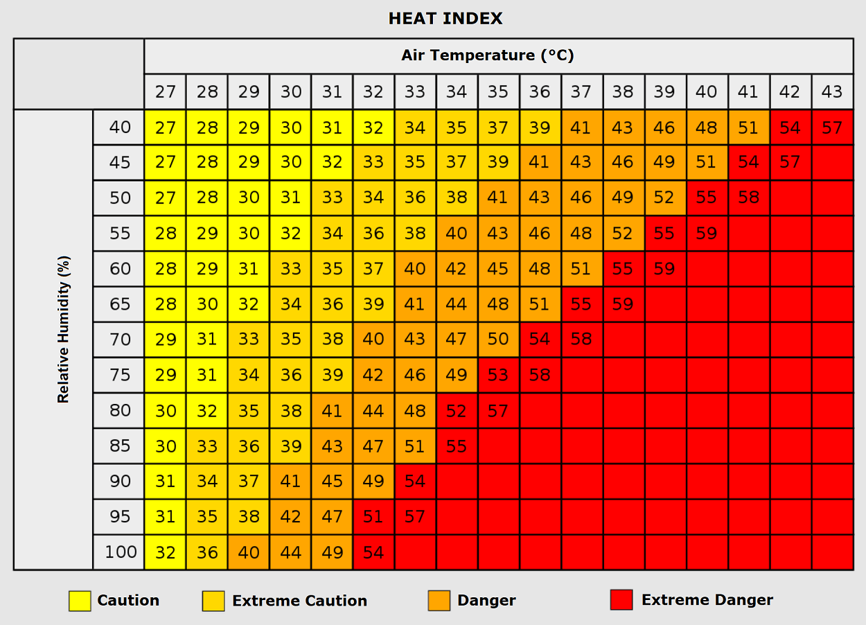
Prolonged exposure to extreme heat places immense strain on the human body, heightening the risk of heat exhaustion, dehydration, and potentially fatal heatstroke. Vulnerable groups—including the elderly, young children, and individuals with pre-existing cardiovascular or respiratory conditions—face disproportionate hazards.
Furthermore, socioeconomic factors heavily influence survival rates during prolonged heatwaves. Urban residents living in densely populated neighborhoods with heat-trapping building materials such as concrete, asphalt, and older insulation standards experience the urban heat island effect intensely. Outdoor laborers, including construction workers and agricultural staff, face elevated occupational hazards due to continuous exposure during peak solar hours.
Energy Grids and Environmental Stresses
The relentless heat drives electricity demand to near-record highs as residential and commercial cooling systems operate at maximum capacity. This surge strains regional power grids, elevating the risk of localized brownouts or failures. Simultaneously, the combination of high temperatures, low relative humidity, and depleted soil moisture creates extreme wildfire danger ratings across southwestern and central Europe, requiring heightened vigilance from emergency services.
Official Responses and Outlook
Civil protection agencies and meteorological institutes across France, the UK, Germany, Italy, and Spain have issued high-level heat advisories, urging citizens to limit outdoor physical activity, stay hydrated, and check on vulnerable neighbors. Municipalities have opened cooling centers and implemented water-distribution measures in major metropolitan areas.
Long-term meteorological trends monitored by forecasting agencies suggest that a significant synoptic pattern flip may finally arrive next week, breaking the blocking high-pressure regime and introducing cooler Atlantic air masses to Western and Central Europe. Until then, populations across the affected regions remain on high alert as the fifth major heat dome reaches its zenith.
