

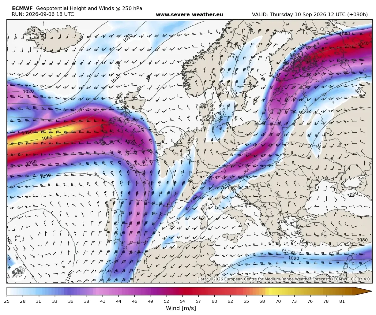
EUROPE — A dramatic meteorological pivot is underway across the European continent, bringing a sudden, violent end to the prolonged early-September Heat Dome that has gripped the region for weeks. Driven by a robust upper-level trough emerging from the North Atlantic, a powerful surface cold front is plowing across Western and Central Europe, crashing directly into a stagnant, record-warm air mass.
This volatile atmospheric collision is triggering a widespread, multi-day severe weather outbreak stretching from the towering peaks of the Alps down into the Western Balkans. Forecasters warn that the combination of extreme atmospheric instability, high moisture anomalies, and intense wind shear will produce hazards ranging from giant hail and destructive straight-line winds to torrential flash floods and localized tornadoes.

Behind this aggressive frontal boundary lies a surge of unseasonably cold, polar-origin air. Within a 24-hour window, daytime high temperatures are expected to plummet by 15°C to 20°C, culminating in the season’s first heavy snowfall across the higher elevations of the Alps and plunging much of the continent into a crisp, autumn-like regime just ahead of the weekend.
Main Facts
- The Catalyst: A potent upper-level trough pushing out of the North Atlantic is dismantling the high-pressure ridge responsible for the persistent early-September Heat Dome.
- The Collision: A strong surface cold front is driving across Western and Central Europe, clashing with an exceptionally warm and moisture-laden air mass fueled by a historic Mediterranean marine heatwave.
- Severe Hazards: The two-day severe weather outbreak threatens Eastern France, Switzerland, the Balearic Islands, Northern Italy, Austria, Slovenia, and Croatia with giant hail, destructive convective wind gusts, torrential downpours, and a localized tornado threat.
- Thermal Collapse: Temperatures are dropping by 15°C to 20°C in less than 24 hours behind the front, forcing a sharp transition from late-summer heat to a brisk autumn environment and bringing the first significant snowfall to high Alpine passes.
- Flash Flood Risks: Slow-moving storms, terrain convergence, and "training" cells (where multiple storms pass over the same area consecutively) are projected to dump 150 to 200 mm of rain locally along Liguria Bay, the North Adriatic coast, and the northwestern Balkans.
Chronology of the Pattern Shift
Monday Night to Tuesday: Initiation and Approach
The atmospheric machinery shifted into high gear late Monday night as the leading edge of the frontal boundary pushed into Western Europe. Anchored by a deep low-pressure system stretching from Scandinavia down toward the Azores, the cold front began its steady march eastward. Ahead of this boundary, a resilient upper-level ridge maintained extreme heat across Central and Eastern Europe, setting the stage for a classic "summer-killer" setup—a meteorological event characterized by the sudden, forceful flushing of prolonged heat by a significantly colder air mass.
Wednesday: The Outbreak Begins in the West and Alps
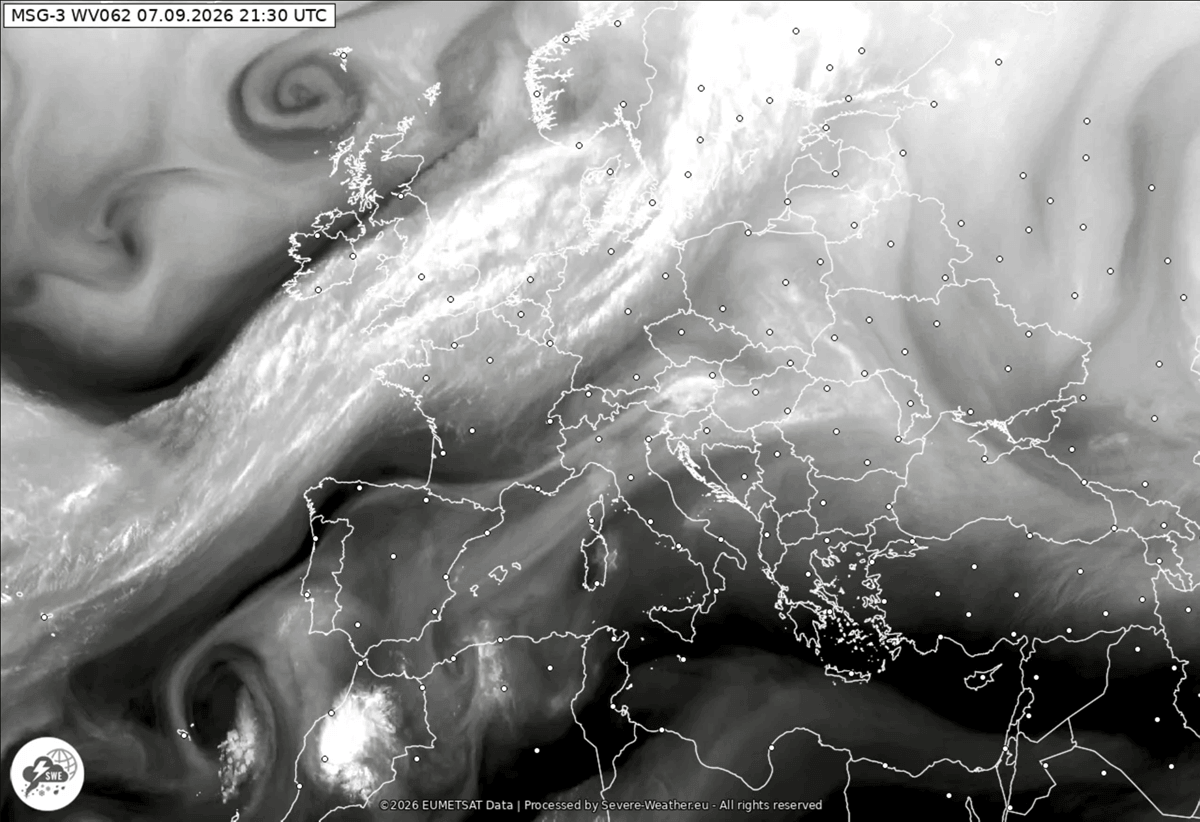
By Wednesday midday, the high-amplitude ridge completely broke down under intense upper-level forcing. As the main upper-level wave propagated eastward, a secondary wave cut off into the Northern Mediterranean, spinning up a surface low that began tracking across Italy toward the Western Balkans.
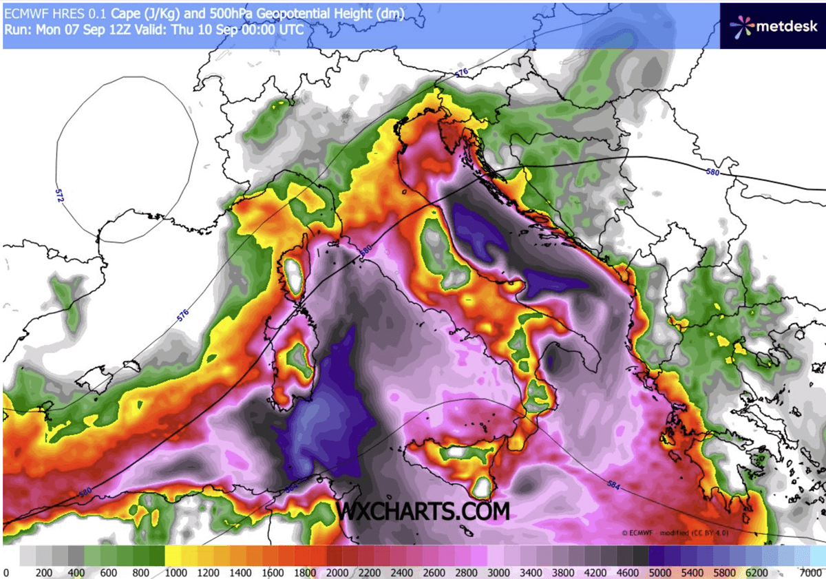
The Balearic Islands experienced the initial wave of violent convective activity by midday Wednesday. As the afternoon progressed, severe multicell and supercell storms erupted across Eastern France, Switzerland, and Northern Italy. These storms capitalized on convective available potential energy (CAPE) values surging past 3,000 to 4,000 J/kg, fueled by extreme moisture streaming off the unusually warm Mediterranean Sea.
Thursday and Beyond: The Balkans and Central Mediterranean
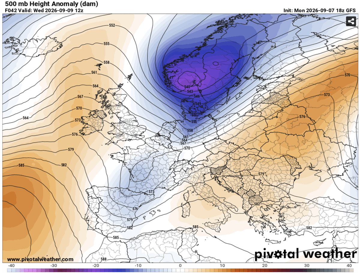
The severe threat shifts further east-southeast on Thursday, targeting Central Italy, the Adriatic Sea, and the Western Balkans. As the cold front encounters local topographical barriers and slows down, storm development becomes increasingly stationary. Coastal areas along Liguria Bay, the North Adriatic, and Tuscany face heightened risks of prolonged heavy rainfall and flash flooding as individual cells train over saturated catchments. Meanwhile, the core of the polar air mass overspreads Central and Western Europe, locking in the autumn-like pattern through the weekend.
Supporting Data and Meteorological Analysis
Synoptic Setup and Jet Stream Dynamics
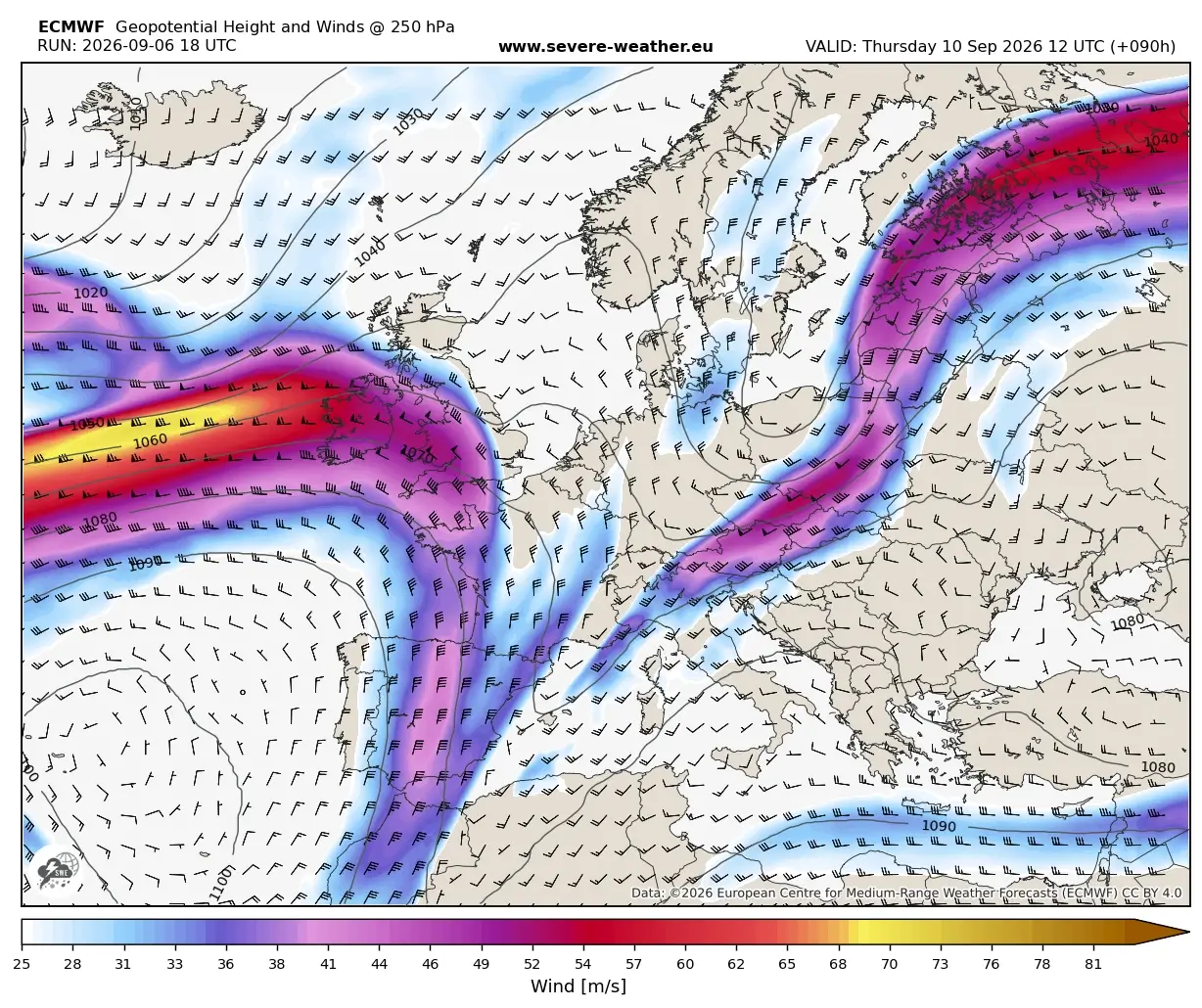
Meteorological models from PivotalWeather and WXcharts illustrate a classic text-book dynamic transition. The pressure and temperature gradients between the departing heat dome and the advancing trough have significantly amplified the jet stream, extending high-velocity winds from the central European continent straight into the Western Mediterranean.
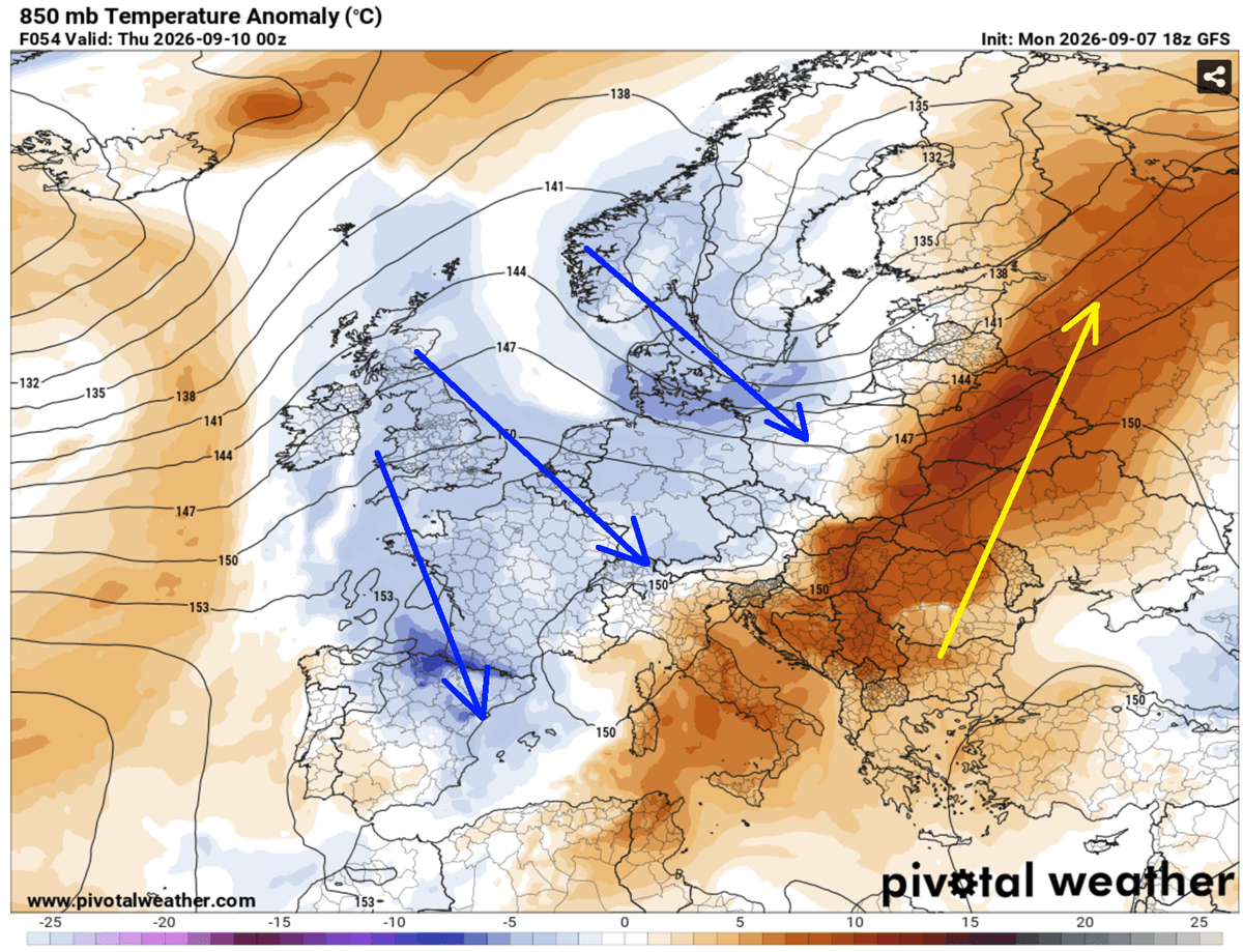
This jet stream positioning provides strong vertical wind shear across the warm sector of the storm system, a critical ingredient for organizing short-lived pulse thunderstorms into rotating, long-lived supercells capable of producing severe weather hazards.
Thermodynamic Instability and Moisture Anomalies
The severity of this outbreak is heavily amplified by the antecedent marine heatwave across the Mediterranean Sea. Because the sea surface temperatures remain exceptionally high, marine moisture content is unseasonably elevated. High dewpoints combine with steep mid-level lapse rates to create a deeply unstable air mass.
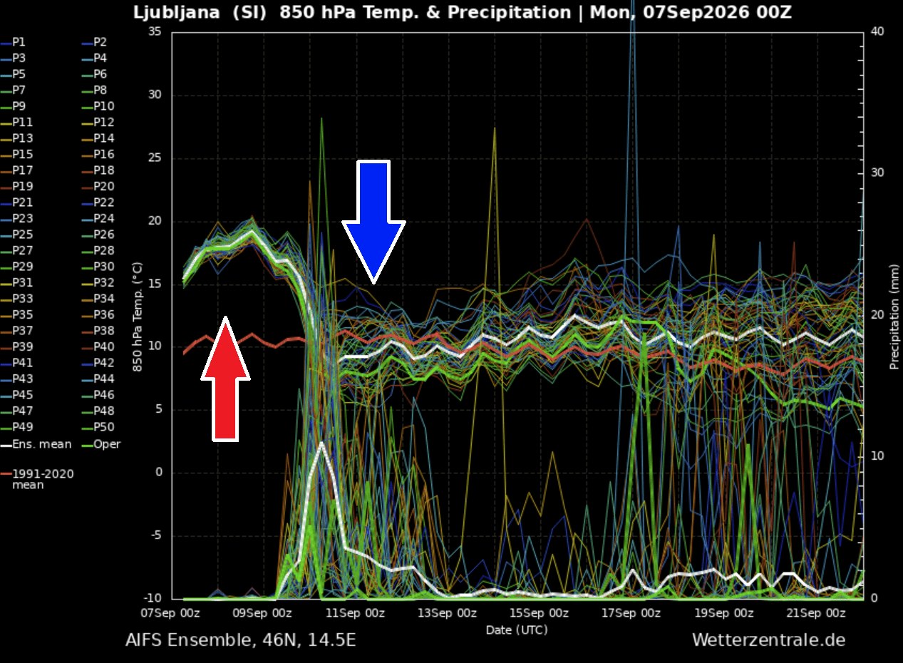
Meteogram forecasts for cities such as Ljubljana, Slovenia, highlight the sheer magnitude of the incoming air mass change. At the 850 mbar level, temperatures hovering near 18°C to 20°C—approximately 10°C above long-term climatological normals—are projected to crash by roughly 15°C in less than 24 hours.
[Temperature Profile Comparison - Ljubljana, Slovenia]
Pre-Frontal (Early Sept):  ~18°C to 20°C at 850 mbar (10°C above normal)
Post-Frontal (Mid-Week):   Rapid 15°C drop within 24 hours
Precipitation Spike:       Heavy rainfall accumulation on Wed/Thu
Official Warnings and Civil Protection Responses
As high-resolution forecast models solidified the threat of a major severe weather outbreak, national meteorological and civil protection agencies across the affected countries issued yellow, amber, and red alerts.
- Italy: The Department of Civil Protection issued widespread alerts for Northern and Central Italy, explicitly warning of flash flooding along the Ligurian and Tuscan coasts, alongside risks of damaging straight-line winds and large hail.
- Switzerland and France: Alpine regions face warnings regarding rapidly deteriorating travel conditions. Authorities cautioned motorists crossing high-mountain passes to prepare for sudden winter-like driving conditions as snow levels drop precipitously.
- Slovenia and Croatia: Environmental agencies activated emergency preparedness protocols for the northwestern Balkans, anticipating torrential downpours that could overwhelm urban drainage systems and trigger rapid rises in small rivers and streams.
Emergency management teams have urged residents and late-season tourists to secure outdoor property, avoid parking vehicles near prone flood zones or under large trees, and monitor real-time radar updates closely as individual storms develop.
Implications of the "Summer-Killer" Pattern
Agricultural and Hydrological Impacts
While the sudden transition brings an abrupt halt to weeks of oppressive heat and drought-worsening dryness, the sheer intensity of the rainfall poses immediate hydrological concerns. Soils baked hard by weeks of relentless sunshine possess severely reduced infiltration rates, heightening the risk of rapid runoff and localized flash floods where 150 to 200 mm of rain falls over a 48-hour period.
Conversely, the long-term agricultural implications are mixed. The influx of much-needed moisture will alleviate prolonged agricultural stress in parts of Central Europe and the northern Mediterranean, though unseasonably early frosts or heavy alpine snow could pose localized challenges for high-altitude viticulture and late-harvest crops.
Seasonal Outlook and Climatological Context
This mid-September pattern shift effectively signals the definitive death knell of meteorological summer across large swathes of Europe. Long-term atmospheric trends analyzed by forecasters suggest that the jet stream will remain highly dynamic as the continent transitions deeper into autumn. With global climate indicators—including discussions surrounding upcoming winter seasonal models and developing El Niño dynamics—continuing to point toward heightened atmospheric variability, this severe weather outbreak serves as an early indicator of a potentially volatile and active transition into the colder months of the year.
