

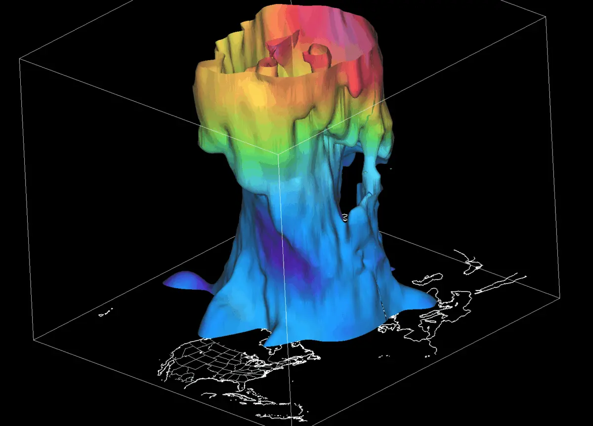
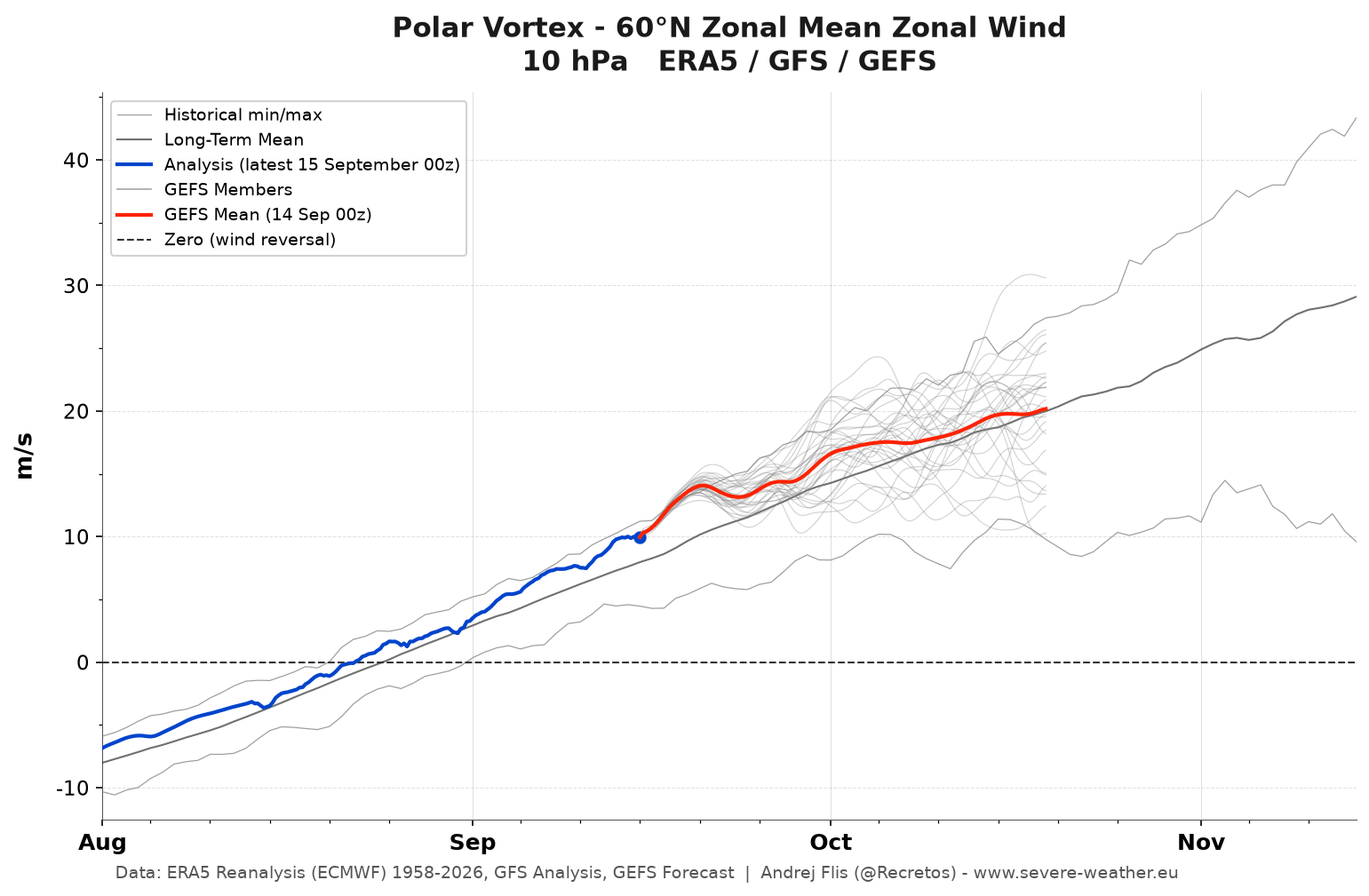
As autumn progresses across the Northern Hemisphere, meteorologists and atmospheric scientists are closely tracking the early formation of the stratospheric Polar Vortex for the upcoming Winter 2026/2027 season. While current initialization data indicates that the vortex is forming faster and stronger than it did at this same point last year, long-range forecasts point toward a dramatic mid-winter shift.

Coupled with the development of a powerful Super El Niño in the tropical Pacific, climate models are projecting a significant mid-season deceleration and potential disruption of the Polar Vortex. For millions of residents across the United States, Canada, and Europe, these atmospheric mechanics could spell the difference between a mild, quiet winter and a series of severe, disruptive Arctic outbreaks.
Main Facts: Anatomy of the Polar Vortex and the 2026/2027 Setup
To understand what lies ahead for Winter 2026/2027, it is essential to examine the engine driving Northern Hemisphere winter weather: the Polar Vortex.
The Dual-Layered Atmospheric Engine
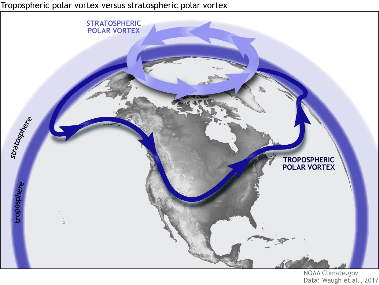
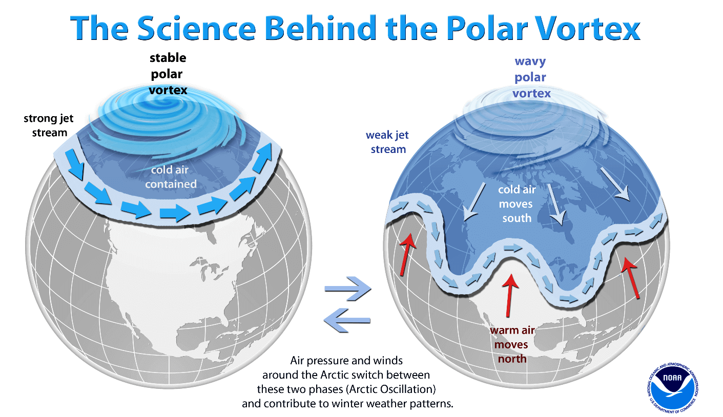
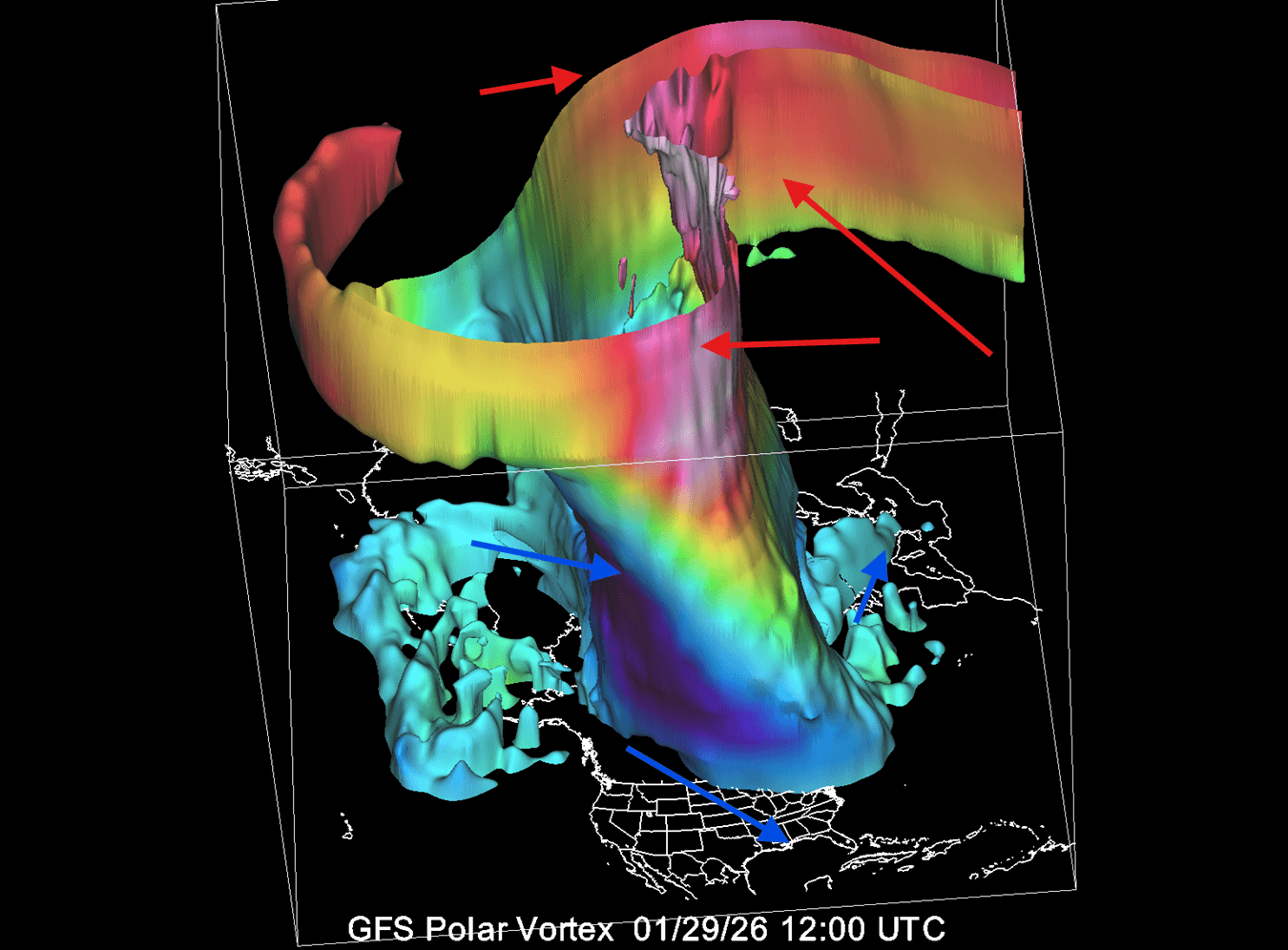
The Polar Vortex is a massive, spinning atmospheric circulation spanning from the Earth’s surface well into the stratosphere—reaching altitudes of over 50 kilometers (30 miles). Meteorologists divide this system into two distinct layers for continuous monitoring:
- The Stratosphere (Upper Layer): Located high above the ground, this upper vortex is largely symmetrical and spins freely in the thin stratospheric air. It acts as the primary containment vessel for frigid Arctic air.
- The Troposphere (Lower Layer): Extending closer to the surface, the lower vortex becomes heavily distorted and "wobbly." Terrain features, massive mountain ranges, and dynamic surface pressure systems force the lower vortex into wave-like patterns.
When the stratospheric Polar Vortex is robust and stable, it acts as a tight barrier, trapping the coldest air safely inside the Arctic Circle. However, when the vortex weakens, stretches, or collapses, those cold "arms" of Arctic air can easily spill southward into the mid-latitudes.
Current 2026/2027 Status
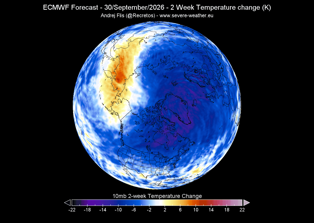
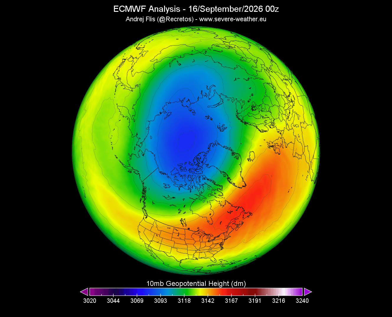
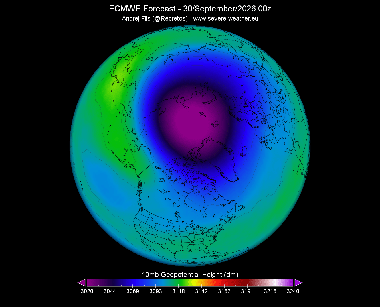
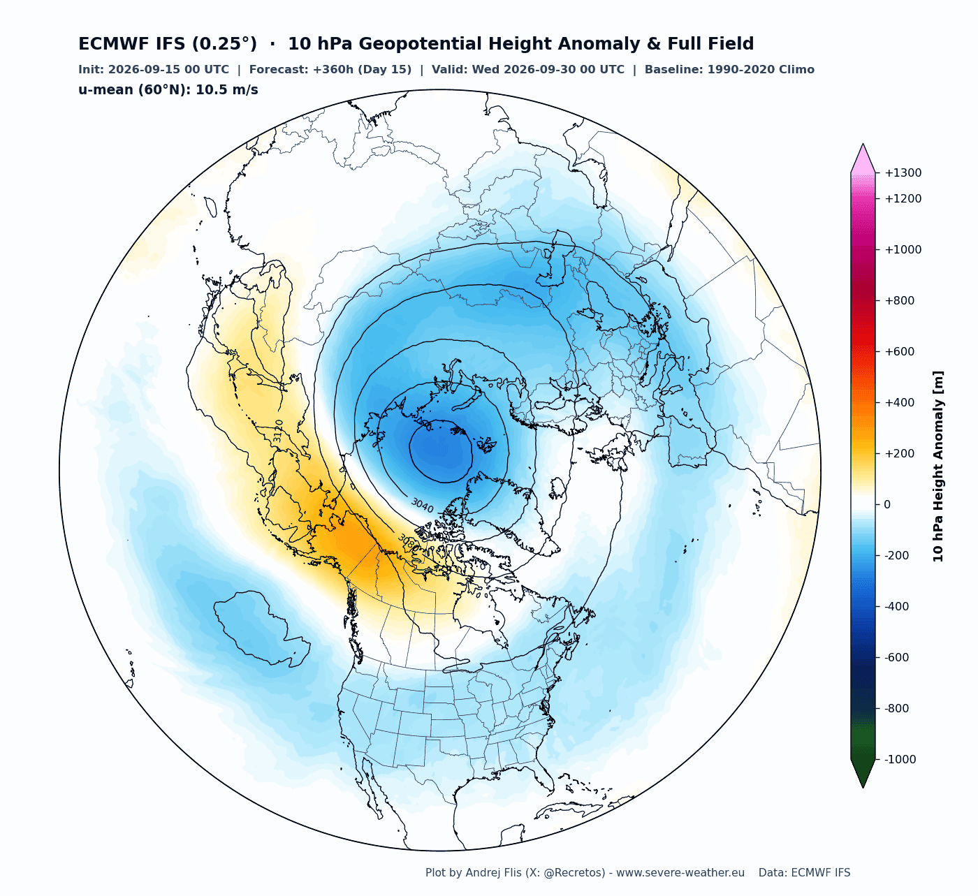
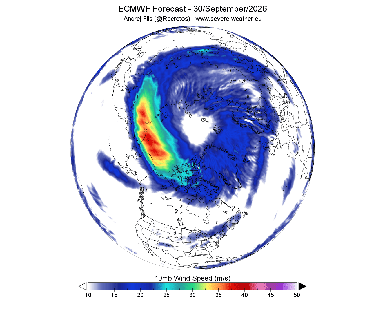
Early observational data from late August and September confirms that rapid stratospheric cooling is underway over the North Pole. A well-defined low-pressure core is already taking shape at the 10-hectopascal (10mb) level—roughly 30 kilometers (18.5 miles) high. Wind forecasts for the mid-stratosphere reveal a tight, circular "donut-shaped" stratospheric night jet, indicating that the vortex is organizing properly and starting the season with above-normal strength.
Despite this formidable early-season start, seasonal forecast models from leading meteorological centers—including the ECMWF and the UKMO—agree on a pronounced slowdown and high-pressure disruption slated for mid-winter.
Chronology: From Autumn Genesis to Mid-Winter Disruption
The lifecycle of the Polar Vortex follows a predictable seasonal rhythm, yet anomalies can radically alter its trajectory.
1. August to October: The Stratospheric Cooling Phase
Cooling begins in the upper stratosphere as polar regions receive less direct sunlight. This temperature drop generates a steep thermal gradient between the freezing pole and the warmer mid-latitudes, driving a rapid drop in stratospheric pressure. By late September, the newly formed vortex achieves a stable, symmetrical configuration.
2. November to December: Early Stability and Initial Signals
As autumn transitions into early winter, global climate models show the Polar Vortex maintaining a relatively stable profile. However, underlying signals begin to emerge. Vertical wave energy—driven by planetary-scale pressure systems propagating upward from the troposphere—begins to exert pressure on the stratospheric structure.
3. January to February 2027: The Forecasted Deceleration Trend
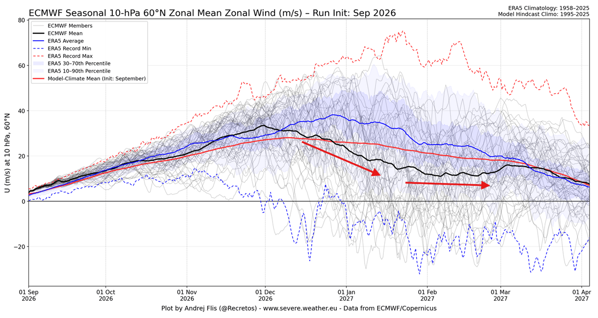
According to extended ensemble data from the ECMWF, the zonal wind speeds around the polar circle are projected to plummet far below long-term climatological averages by January 2027. This sharp deceleration signifies a major disruption trend.
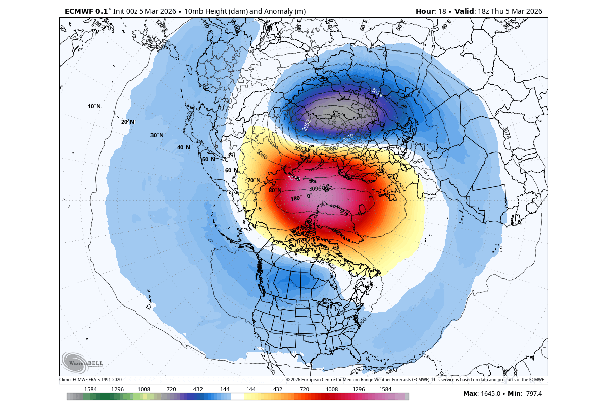
Rather than maintaining a tight, circular containment ring, the stratospheric vortex is expected to experience a significant influx of high-pressure and warm-air anomalies. This evolution points toward a classic atmospheric pattern precursor to a Sudden Stratospheric Warming (SSW) event or a full-scale vortex displacement.
Supporting Data and Meteorological Modeling
Forecasting stratospheric behavior months in advance is notoriously challenging, but modern atmospheric science relies on multi-model ensembles and historical analogs to gauge probabilities.
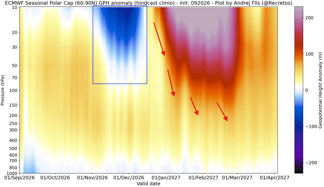
The ECMWF and UKMO Ensemble Signals
Both the European Centre for Medium-Range Weather Forecasts (ECMWF) and the United Kingdom Meteorological Office (UKMO) seasonal suites are flashing warning signs for the mid-winter stratosphere.
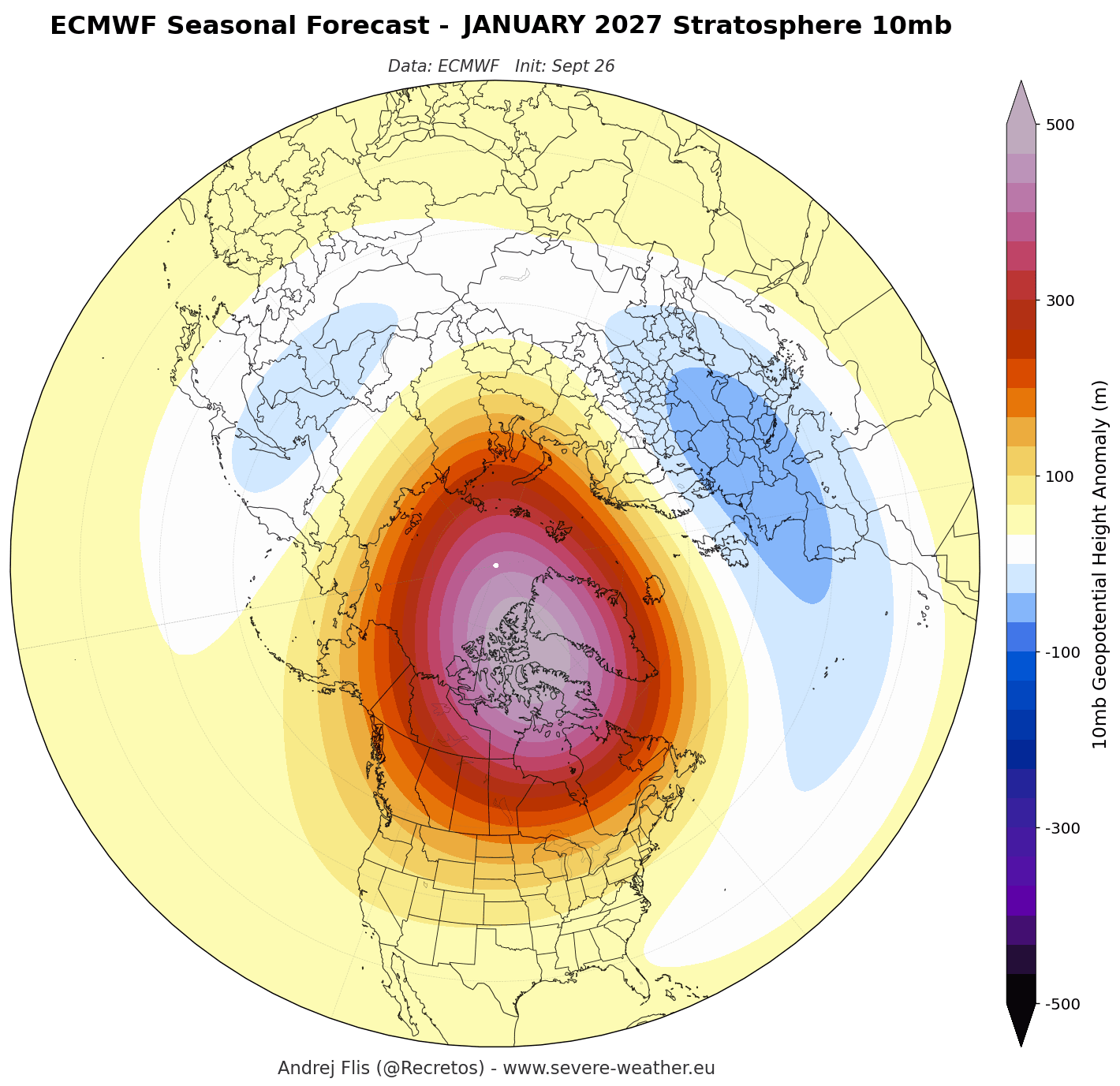
- Zonal Wind Anomalies: Forecast lines for 10mb zonal winds drop significantly below normal thresholds by January and February 2027, indicating a weakened state or a potential wind reversal.
- Pressure Anomalies: Height and pressure forecasts highlight the development of a powerful high-pressure anomaly over the polar stratosphere in mid-winter. This high-pressure wave effectively combats the cyclonic spin of the vortex, squeezing its core and dampening its momentum.
The Super El Niño Connection
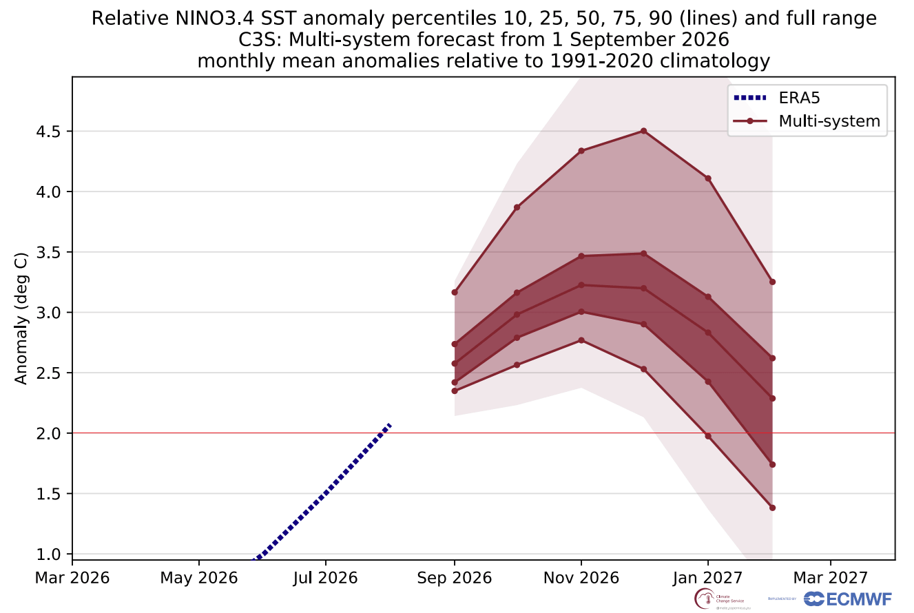
Adding a critical layer of complexity to the Winter 2026/2027 outlook is the rapid emergence of a Super El Niño in the tropical Pacific. Current ocean temperature forecasts from the NMME (North American Multi-Model Ensemble) and Copernicus models show sea surface temperature anomalies soaring past the +2°C threshold, placing this event among the strongest El Niño episodes in decades.
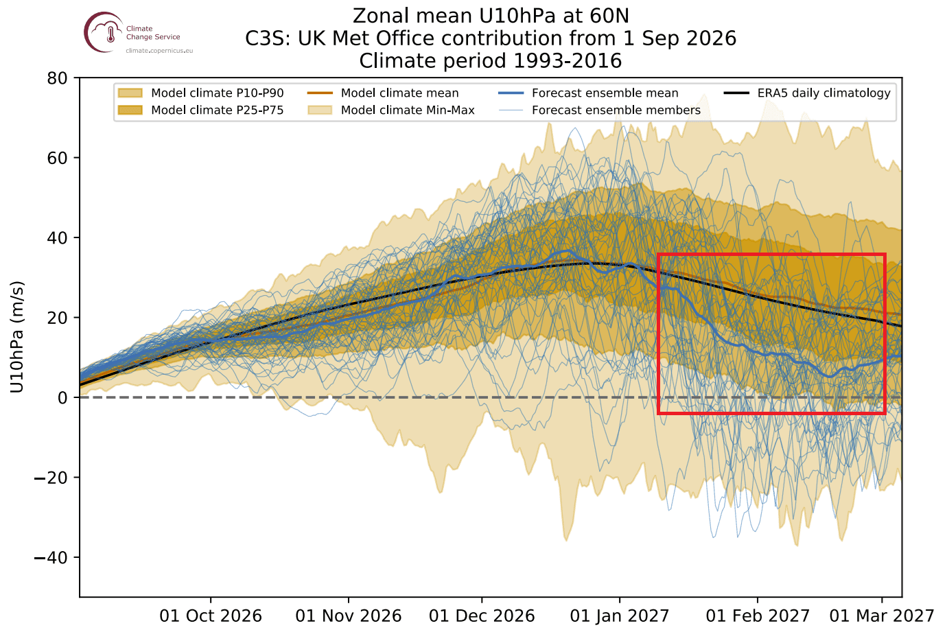
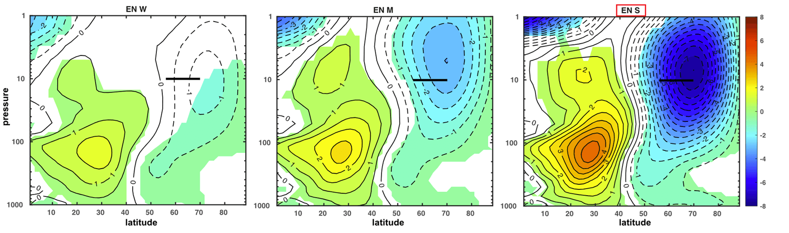
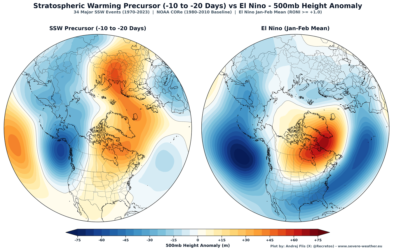
Historical climate studies and atmospheric simulations demonstrate a clear teleconnection between strong El Niño events and stratospheric dynamics. Specifically, a robust El Niño alters global planetary wave patterns—often inducing a low-pressure anomaly in the North Pacific and a high-pressure zone over Greenland and northern Canada.
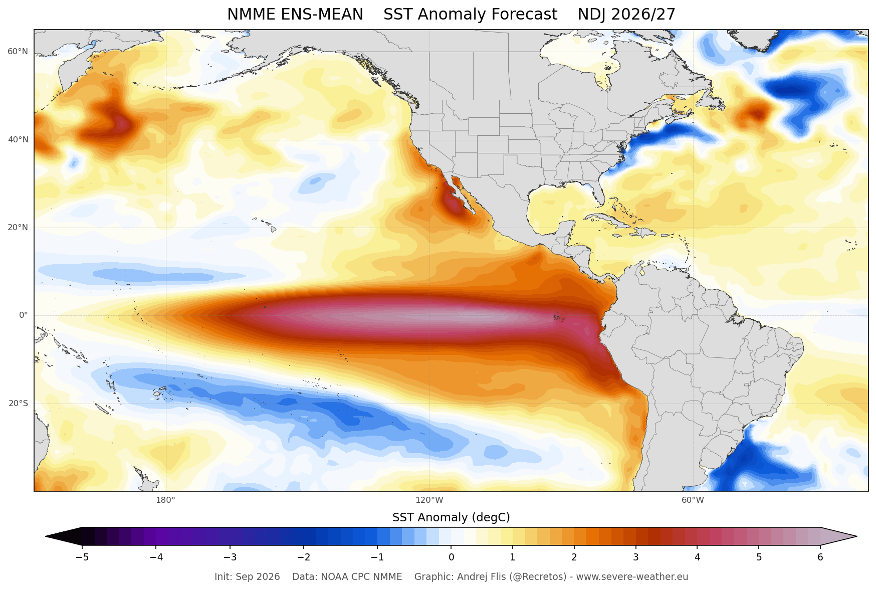
This specific configuration acts as a massive atmospheric "firehose," pumping vertical wave energy upward into the stratosphere. This energy disrupts the Polar Vortex, frequently triggering the deceleration trends and SSW events observed in seasonal models.
Official Responses and Scientific Consensus
While commercial weather services and independent meteorologists analyze these long-range trends, global climate agencies continuously monitor the stratosphere to refine sub-seasonal risk assessments.
Insights from NOAA and Climate Research
Institutions such as the National Oceanic and Atmospheric Administration (NOAA) emphasize that while a direct, week-by-week forecast of a Sudden Stratospheric Warming cannot be accurately locked in during September, the structural preconditions are undeniable.
Research into past Super El Niño winters—such as the historic 2015/2016 season—reveals consistent patterns of stratospheric disruption. During those winters, stretched or split vortex structures frequently forced frigid Arctic air masses into the United States and Europe.
The Mechanics of a Collapse Event
When an SSW or full vortex collapse occurs, the physical impacts unfold in a well-documented sequence:
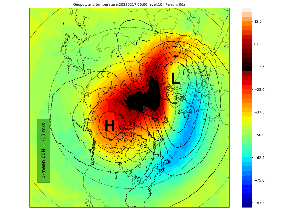
- The Trigger: Warmth and high-pressure waves surge into the stratosphere, rapidly spiking polar stratospheric temperatures by tens of degrees within days.
- The Breakdown: The vortex either splits into two distinct cores (a "split event," often yielding fast and persistent surface impacts) or gets shoved aside (a "displacement event").
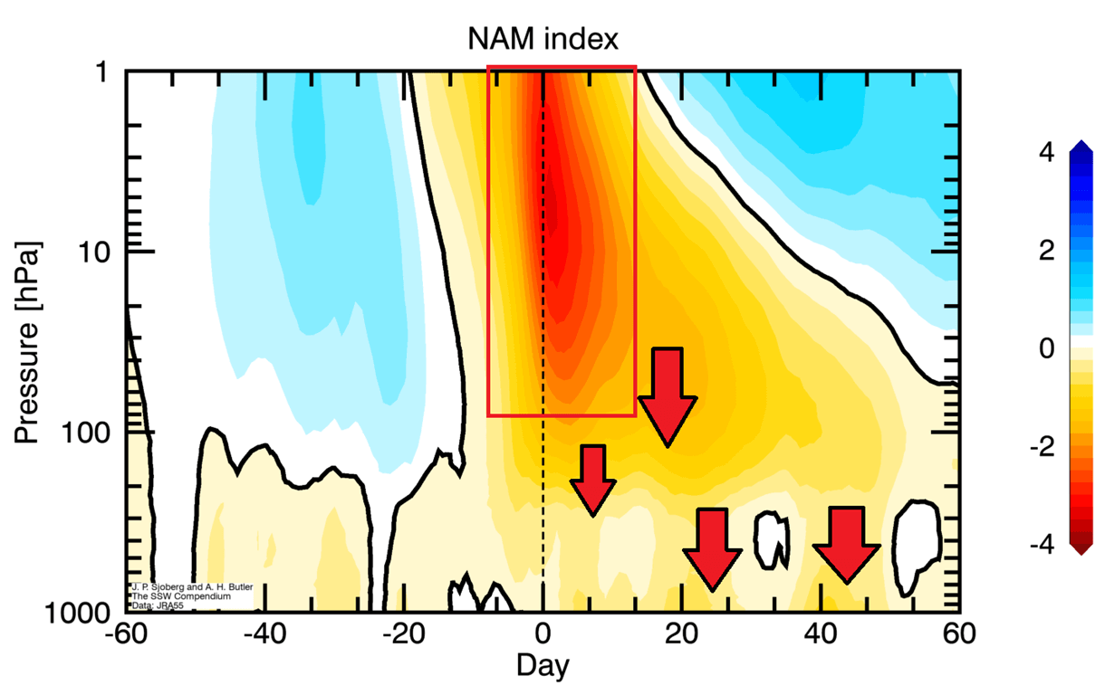
- The Downward Propagation: Over a 10-to-30-day lag period, the high-pressure anomaly works its way down through the atmospheric layers, ultimately altering the tropospheric jet stream at the surface.
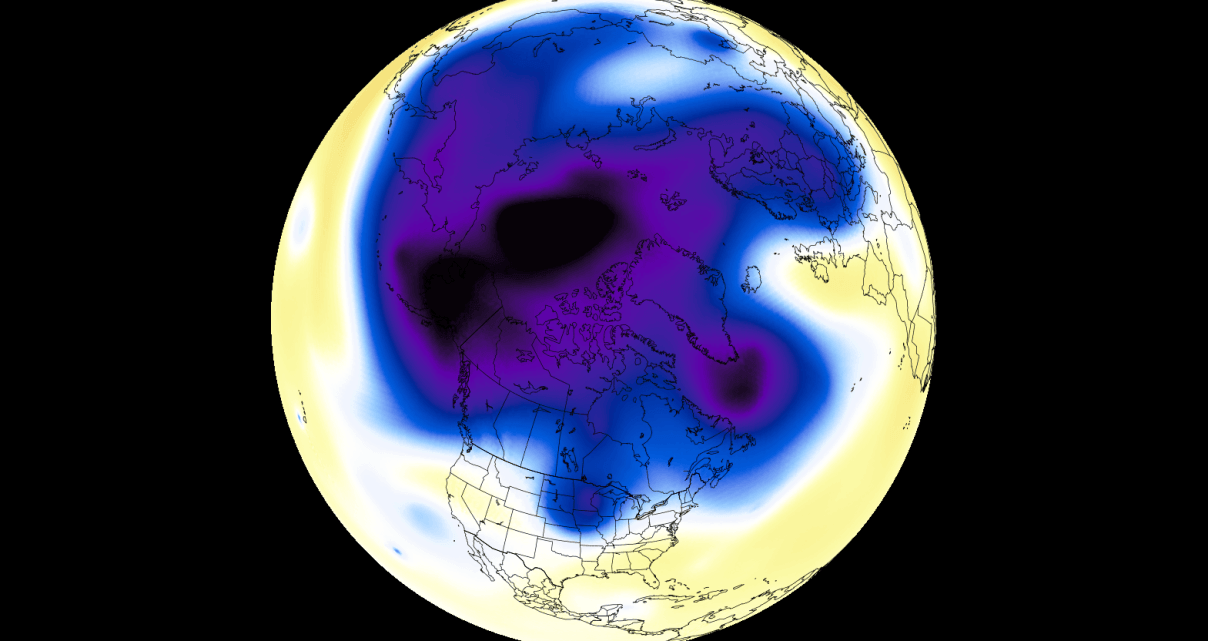
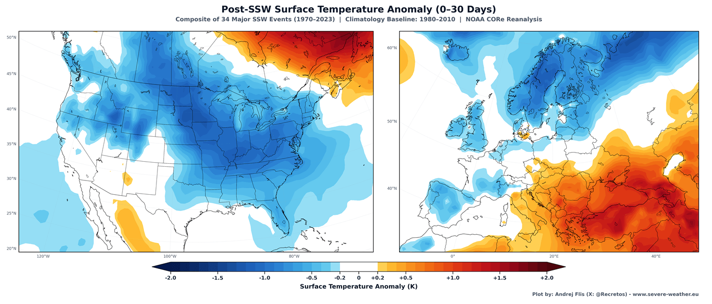
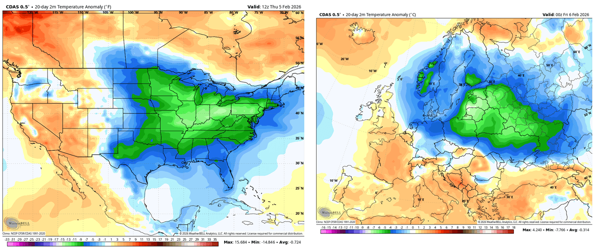
Following historical SSW events, composite temperature anomaly maps show that a large portion of the United States, central and northern Canada, and northern and central Europe experience significantly colder-than-average conditions.
Implications for Winter 2026/2027: What to Expect
If the current long-range modeling and Super El Niño teleconnections hold true, the implications for the upcoming cold season are profound.
United States and Canada
A weakened or disrupted Polar Vortex typically breaks down the traditional Pacific jet stream, replacing it with amplified, highly meridional (north-south) flow patterns. Often referred to as establishing the "Polar Express," this dynamic increases the frequency of deep Arctic outbreaks dipping straight down from Canada into the central and eastern United States. Rather than a uniformly cold winter, North America could experience sharp, volatile temperature swings—bouncing between unseasonably mild periods and severe, high-impact winter storms laden with heavy snowfall.
Europe
For Europe, a disrupted stratospheric vortex often breaks down the mild westerly maritime flow from the Atlantic. This allows high-pressure blocking patterns to form over Scandinavia or the North Atlantic, opening the door for bitterly cold easterly or northeasterly continental winds to sweep across northern and central Europe.
Conclusion
As the atmospheric transition from autumn to winter unfolds, meteorologists will maintain round-the-clock vigilance over stratospheric data feeds. While the 2026/2027 Polar Vortex begins its life cycle in a healthy, robust state, the convergence of a mid-winter deceleration trend and a powerful Super El Niño points toward a volatile and potentially severe winter season. Communities across North America and Europe are advised to monitor updated forecasts as the season progresses and prepare for the increased likelihood of disruptive winter weather.
