

EUROPE — A powerful and potentially historic two-day severe weather outbreak is zeroing in on parts of the western and northern Mediterranean. Meteorological authorities have issued high-tier alerts spanning from Wednesday, September 9, through Friday afternoon, September 11, 2026.
A volatile combination of extreme atmospheric instability, unprecedented sea surface temperatures, and vigorous wind shear is expected to unleash a barrage of severe convective storms. Forecasters warn of widespread threats, including giant hail measuring up to 10 centimeters (4 inches) or larger, destructive straight-line winds, intense tornadoes, and catastrophic flash flooding capable of inundating local communities from the Balearic Islands across southern France, northern Italy, and into the western Balkans.

Main Facts
The incoming severe weather event is driven by a potent synergy of large-scale dynamic forces and anomalous thermal energy stored within the Mediterranean basin:
- Event Timeline: The primary convective outbreak runs continuously from Wednesday morning, September 9, through Friday afternoon, September 11, 2026.
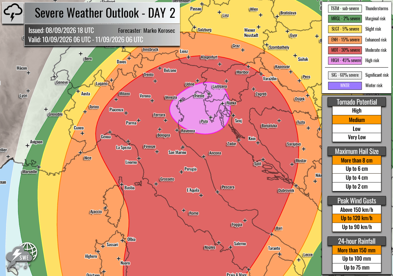
- Geographic Scope: Regions under the highest threat levels include the Balearic Islands, southern Corsica, Sardinia, Liguria, Tuscany, northeastern Italy, northern Adriatic coastal zones, western Slovenia, and northwestern Croatia.
- Primary Hazards: Forecasters have highlighted multiple high-impact hazards:
- Giant Hail: Stones ranging from 6 to 10 cm (or larger) capable of severe structural and vehicular damage.
- Destructive Winds: Severe straight-line wind gusts capable of downing trees and power lines.
- Tornadoes: A pronounced threat of tornadic supercells, particularly in low-level shear zones around the Balearic Islands and the western side of the Italian Apennines.
- Catastrophic Flash Floods: Localized rainfall accumulations exceeding 200 to 300 millimeters within a 36-hour window, elevating risks for sudden, dangerous flooding following extended periods of regional drought.
- Driving Mechanisms: A deep upper-level trough pushing out of Western Europe is colliding with a collapsing blocking high-pressure system to the east. This creates a powerful southwesterly jet stream overhead. Beneath this jet, surface air is exceptionally humid, supercharged by an ongoing historic marine heatwave across the Mediterranean Sea.
Chronology of the Outbreak
The multi-day severe weather sequence is projected to evolve systematically as a sharp cold front races eastward from the Alpine region toward the Balkans.
Wednesday, September 9: The Western Mediterranean and Italian Coastline
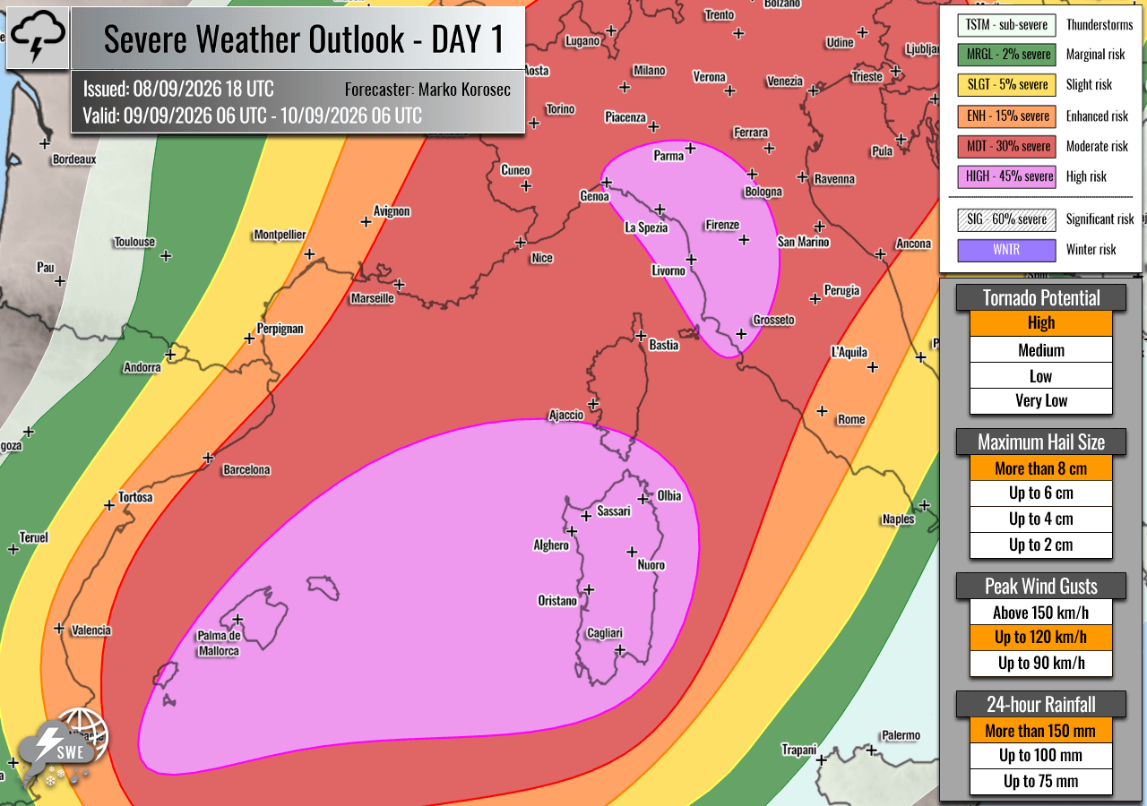
The outbreak initiates early Wednesday morning over the Balearic Islands and the Ligurian Bay. Strong westerlies aloft are rapidly advecting deep moisture from the central Mediterranean basin toward Spain’s eastern islands and the Italian peninsula.
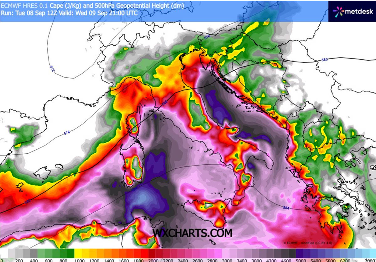
With dewpoints climbing near or above 25°C, mixed-layer convective available potential energy (MLCAPE) values are forecast to surge between 3,000 and 4,000+ J/kg. This extreme instability, combined with intense wind shear from a robust mid-level jet, will foster the explosive development of isolated, highly violent supercells.
- Morning to Afternoon: Severe storms erupt over the Balearic Islands, where optimal storm-relative helicity and low-level shear maximize the threat of tornadoes and very large hail. As these systems move east-northeast during the afternoon, they threaten southern Corsica and Sardinia with damaging wind clusters.
- Late Afternoon to Evening: Activity intensifies along the Ligurian and Tuscan coastal areas. Intense southeast low-level flow along the western flanks of the Apennines elevates the potential for tornadic supercells. Simultaneously, heavy rainfall begins pooling over interior districts.
- Overnight: Storms are expected to merge into large, menacing clusters, sweeping across northern Italy and approaching western Slovenia and northwestern Croatia by late evening. Damaging winds and torrential downpours remain the primary overnight hazards.
Thursday, September 10: Northern Italy, the Adriatic, and the Western Balkans
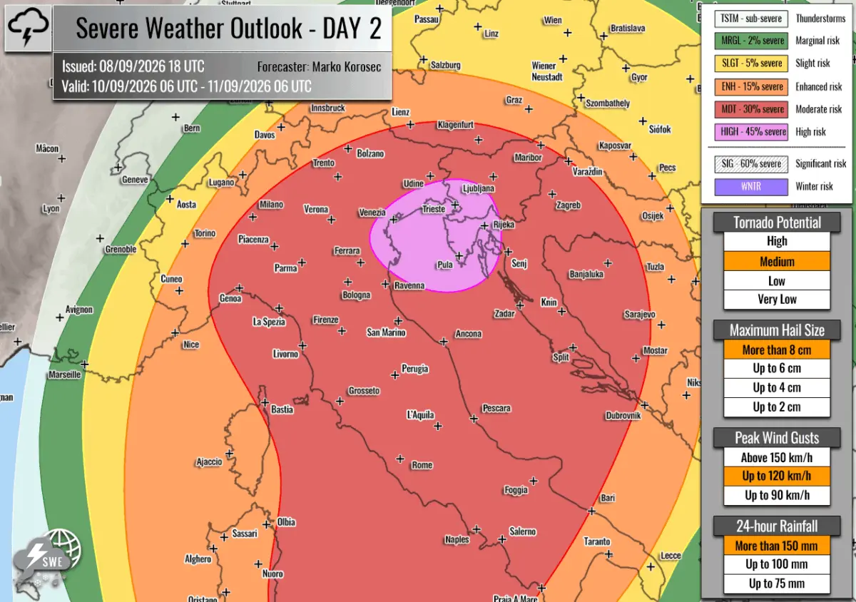
The core of the severe weather shifts eastward on Thursday, targeting northeastern Italy, the northern Adriatic Sea, western Slovenia, and northwestern Croatia under a newly minted HIGH risk zone.
- Daytime Evolution: Widespread thunderstorm activity persists from the overnight complexes, while fresh, slow-moving multicells and supercells regenerate throughout the day. Extreme instability and deep-layer wind shear continue to feed the storms as they organize into large convective systems by afternoon.
- The Training Storm Threat: Beyond discrete supercell hazards (giant hail, tornadoes, and destructive winds), the primary concern on Thursday shifts to persistent training cells—storms repeatedly moving over the same geographic areas. Repeated waves of precipitation from Wednesday night through Friday midday threaten to push rainfall totals to dangerous levels, with some locales expected to record 200–300 mm in just over a day.
- Evening and Night: The severe threat extends into eastern north-central Italy, the Tyrrhenian and Adriatic Sea corridors, southern Croatia, and western Bosnia. Damaging gusts and torrential rains will continue to pose severe logistical and safety challenges.
Supporting Meteorological Data
The severity of the upcoming weather event is underscored by numerical weather prediction models and environmental parameters analyzed by forecasters at Severe Weather Europe:
- Instability (CAPE): Widespread MLCAPE values exceeding 3,000 to 4,000 J/kg indicate an exceptionally buoyant atmosphere. This energy reservoir will allow updrafts to reach extreme heights, sustaining large hailstones and torrential rainfall rates.
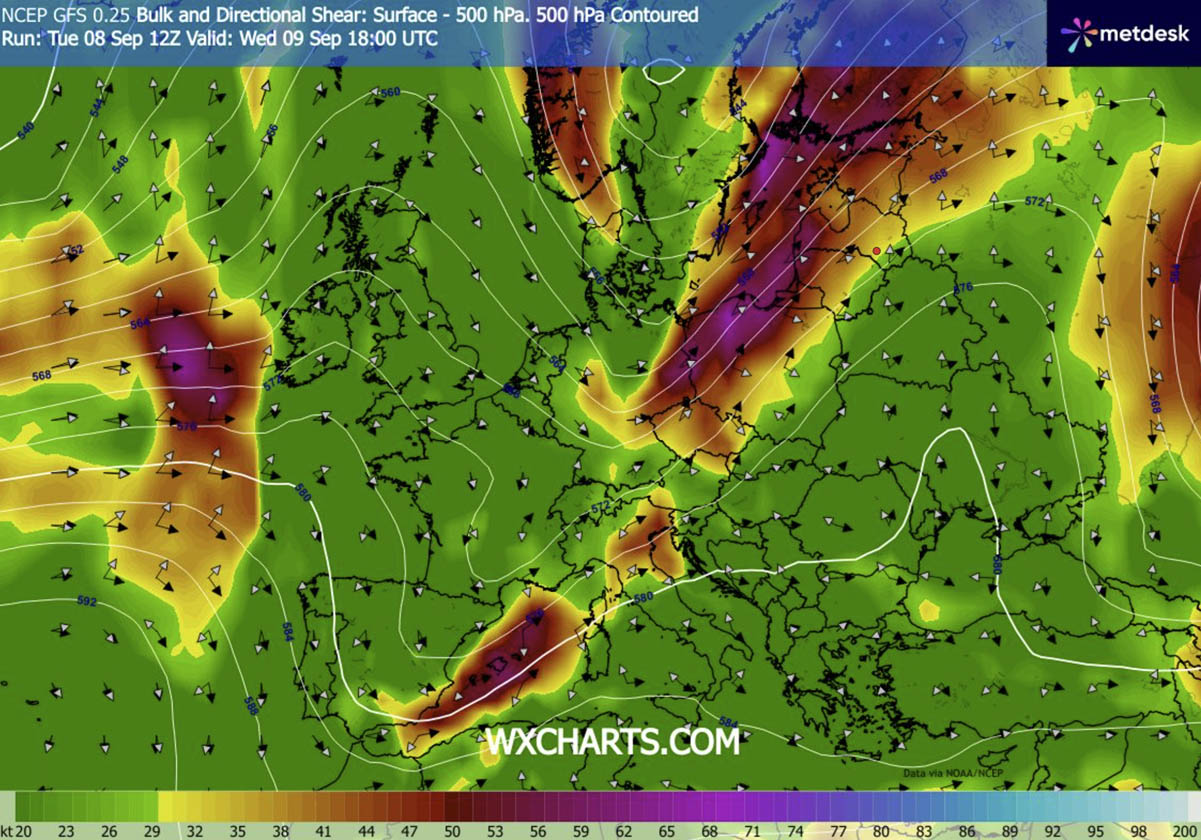
- Wind Shear and Dynamics: The presence of a strong upper-level trough interacting with a departing ridge generates an intense southwesterly jet stream. Strong forcing near the jet’s left exit region, combined with significant directional and speed wind shear, ensures that storms will quickly organize into long-lived supercells capable of rotating updrafts and persistent surface threats.
- Marine Heatwave Coupling: The Mediterranean Sea’s abnormally high surface temperatures have acted as a thermal engine, pumping unseasonably high moisture and high dewpoints into the lower troposphere. This acts as prime fuel for explosive convective initiation once the incoming cold front triggers the unstable air mass.
- Precipitation Totals: High-resolution modeling highlights localized rainfall accumulations reaching or exceeding 200–300 mm. Coming on the heels of protracted seasonal drought across parts of southern Europe, baked and hardened soils will struggle to absorb such staggering volumes of water rapidly, exacerbating the flash-flood risk.
Official Responses and Preparedness
In light of the severe multi-day outlook, civil protection agencies, emergency services, and meteorological offices across the impacted nations have begun issuing localized weather warnings and advisories.
- Alert Levels: Forecasters have instituted HIGH and MDT (Moderate) risk zones for parts of Spain (Balearic Islands), France (Corsica), Italy, Slovenia, and Croatia. Authorities urge residents within these purple- and orange-highlighted zones to monitor real-time radar data and local emergency broadcasts closely.
- Preparedness Measures: Emergency management teams recommend securing outdoor property, vehicles, and temporary structures against destructive wind gusts and potential large hail impact. Municipalities prone to urban flooding have been placed on standby to deploy flood barriers and clear drainage systems ahead of the torrential downpours.
- Travel Warnings: Transportation authorities anticipate significant disruptions to both regional air and maritime travel across the Balearic Sea, the Ligurian Sea, and the northern Adriatic due to low visibility, severe turbulence, and dangerous gale-force convective gusts. Motorists are advised to avoid non-essential travel during the peak of the storms, particularly in flash-flood-prone valleys and low-lying coastal roads.
Implications
This severe weather outbreak carries profound implications for ecosystems, infrastructure, and agriculture across the western and northern Mediterranean:
- Agricultural Impact: The threat of giant hail (6–10 cm) poses a catastrophic risk to late-season agricultural yields, vineyards, orchards, and greenhouses across northern Italy, the Balkans, and the Balearic Islands. Furthermore, torrential rains and high winds could flatten standing crops.
- Infrastructure and Urban Resilience: Urban centers unaccustomed to such extreme short-duration rainfall rates face severe infrastructure strain. Drainage systems overwhelmed by hundreds of millimeters of rain in short windows can lead to rapid urban inundation, stranding motorists and damaging residential and commercial ground floors.
- Hydrological Reversal: While the excessive rainfall threatens immediate destructive flash floods, water management authorities note that the moisture influx will temporarily alleviate severe hydrological droughts that have plagued parts of southern Europe and the northern Balkans over recent months. However, the high runoff coefficient of drought-stricken soils means that much of the water will result in immediate flooding rather than deep soil replenishment.
- Climate Context: Meteorologists point out that the intensity of this event highlights the growing risks associated with abnormally warm Mediterranean sea surface temperatures. Enhanced thermal energy in the marine boundary layer increasingly provides the raw thermodynamic fuel needed to transform standard frontal passages into violent, high-impact severe weather outbreaks.
Data and outlook analysis provided by Severe Weather Europe and forecaster Marko Korošec, with supplemental visual data courtesy of PivotalWeather.
