

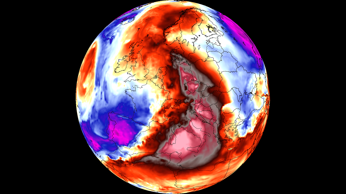
EUROPE — As the summer of 2026 enters its final stretch, large swaths of Southern, Central, and Eastern Europe are once again bracing for intense thermal stress. A stubborn, highly anomalous blocking high-pressure system—colloquially and scientifically termed a "heat dome"—has parked over the Central Mediterranean and Southern Europe. This marks the sixth powerful heatwave of the season, threatening to push temperatures well into the low 40s Celsius while sparking severe weather hazards along its periphery.
Meteorologists report that the atmospheric architecture driving this event is exceptionally resilient. The heatwave is expected to peak between Thursday and Saturday, before gradually shifting eastward and losing intensity by early next week as cooler maritime air pushes into Western Europe.
Main Facts: The Anatomy of Europe’s Sixth Heat Dome
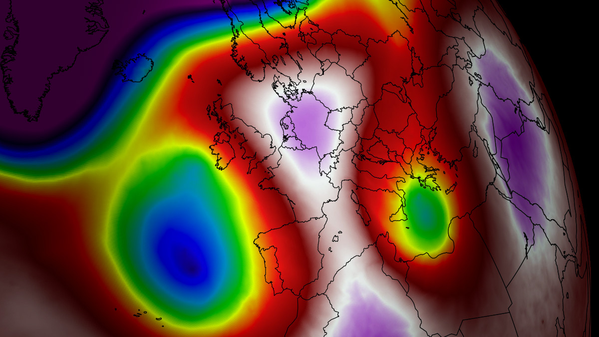
The core driver of this late-summer thermal surge is an expansive upper-level ridge originating from North Africa. As this high-pressure system anchors itself over the Mediterranean basin, it creates a atmospheric lid that traps warm air at all levels.
- Temperature Anomalies: Peak afternoon surface temperatures across low-lying river basins, valleys, and plains are forecast to range between 38°C and 43°C (100°F to 109°F). These values sit 12°C to 16°C above the long-term climatological norm for late August.
- Geographic Spread: The most severe anomalies are concentrated across Italy, the Pannonian plains of Hungary, northern Serbia, eastern Croatia, and Bosnia and Herzegovina. The heat plume is also expanding northward into Central Europe, including Germany, the Czech Republic, and Slovakia, before shifting toward Poland and western Ukraine by the weekend.
- The "Tropical Nights" Crisis: Unlike typical summer weather where temperatures dip overnight, urban corridors are experiencing relentless "tropical nights." Low temperatures are refusing to drop below 22°C to 26°C (72°F to 79°F), denying residents vital physiological relief and accumulating severe health risks.
- Collateral Hazards: The combination of dry continental winds, intense solar radiation, and depleted soil moisture has drastically elevated wildfire risks across southern and central European valleys. Concurrently, the sharp thermal gradient along the heat dome’s western edge is triggering a high-end severe thunderstorm threat across France and the western Alps.
Chronology: How the Late-August Thermal Surge Unfolds
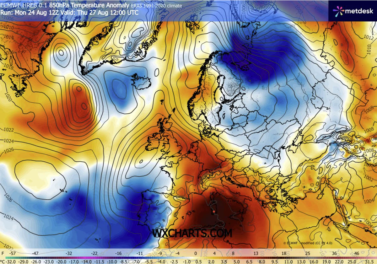
The progression of this weather event involves a dynamic interplay between a stubborn Mediterranean blocking high and a deep, unseasonably strong trough over the Bay of Biscay and western Iberia.
Mid-Week: The Peak over the Mediterranean and Italy
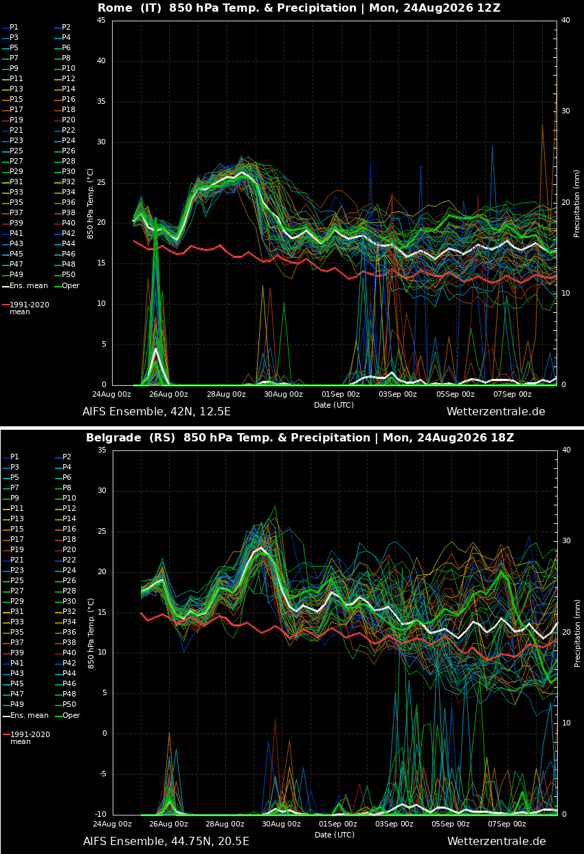
By Wednesday, the North African ridge pushed aggressively northward, anchoring itself firmly across Italy and the central Mediterranean. Daytime highs in the Po Valley and southern Italian regions began crossing the 40°C threshold. Simultaneously, a warm plume extended across the Alps, introducing brief, stifling heat into parts of Germany and Central Europe on Thursday.
Thursday to Saturday: Maximum Intensity in the Balkans
The heatwave reaches its absolute peak from Thursday through Saturday. During this window, the upper-level ridge stretches eastward. Countries across the central Balkans—including Serbia, Bosnia, and Croatia—will record their highest temperatures of the week, with local mercury readings touching 42°C to 43°C.
At the same time, the western flank of the blocking pattern is interacting with cool Atlantic maritime air. This dynamic creates an extreme temperature contrast over France, priming the region for explosive convective activity and severe storms by Thursday afternoon.
The Weekend Shift: Eastward Migration and Western Relief
As the weekend progresses, the elongated heat dome shifts further east and northeast. The center of extreme heat migrates away from Central Europe, bringing soaring temperatures to Poland and western Ukraine by Sunday. Conversely, a refreshing Atlantic airmass will finally breach Western and Southwestern Europe, lowering temperatures significantly across Portugal, Spain, France, and the UK.
Supporting Data: Meteorological Mechanics and Regional Breakdowns
Atmospheric Dynamics: Understanding the Heat Dome
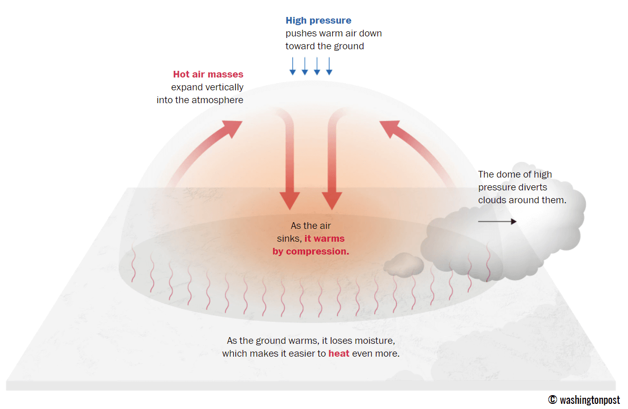
To understand the severity of the current event, meteorologists point to the classic mechanics of a heat dome. An upper-level ridge functions much like a lid on a boiling pot of water.
[ Upper-Level High-Pressure Ridge (The "Lid") ]
                     │
         (Sinking Air / Adiabatic Compression)
                     ▼
[ Trapped Warm Air Mass in Lower Troposphere ]
                     │
                     ▼
[ Extreme Surface Heat & Minimized Nocturnal Cooling ]
As large-scale air masses sink toward the surface, they undergo adiabatic compression—meaning the air warms as it is squeezed under higher pressure. This process clears the skies of clouds, allowing maximum solar radiation to bake the ground, which in turn dries out soils and accelerates further atmospheric heating through sensible heat flux.
Regional Breakdown of Daytime Highs
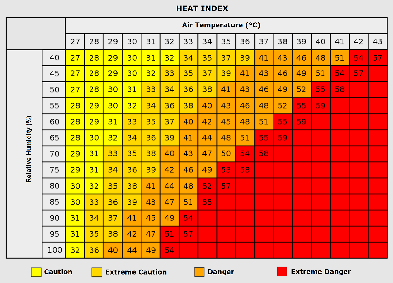
- Southern Europe (Italy & Balkans): Italy and the central Balkans bear the brunt of the heat. Cities in the Po Valley and Pannonian plains are registering maximums between 40°C and 43°C through Friday. Greece and surrounding Aegean areas are similarly flirting with the upper 30s.
- Central Europe (Germany, Alps, and Visegrád Group): On Thursday, a brief surge pushed temperatures in the Alpine regions and parts of Germany to between 32°C and 36°C. While a western airmass will temporarily cool Germany by Friday, the heat shield remains entrenched over the Czech Republic, Slovakia, and Hungary.
- The Western Fringe (France and the Alps): While much of the continent bakes, France sits on a dangerous atmospheric knife-edge. A deep Atlantic wave clashing with the Mediterranean ridge is generating extreme vertical wind shear. Coupled with a Mediterranean-fueled marine heatwave pumping 3000 to nearly 5000 J/kg of Convective Available Potential Energy (CAPE), the region faces a severe storm outbreak characterized by giant hail, destructive straight-line winds, torrential downpours, and isolated tornadoes.
Official Responses and Public Health Implications
Public health authorities and civil protection agencies across Italy, the Balkans, and Central Europe have issued widespread heat advisories and red-flag warnings. The prolonged nature of this event, now stretching into its sixth iteration this season, has strained municipal resources and emergency response networks.
Physiological Strain and Vulnerable Populations
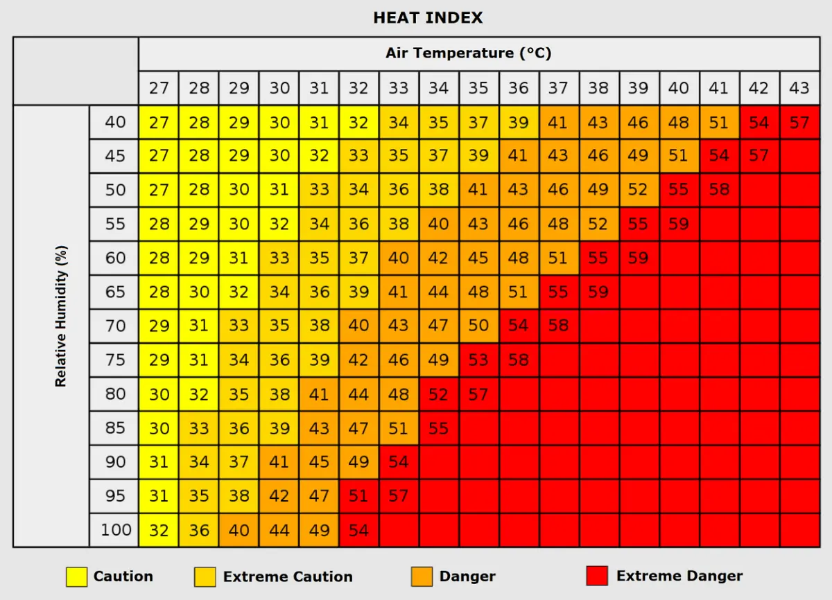
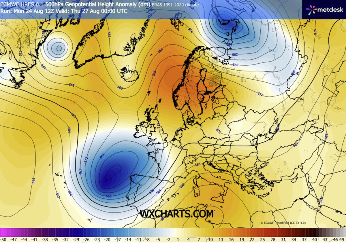
Health experts emphasize that the danger of a heat dome extends far beyond daytime thermometer readings. The persistence of "tropical nights"—where indoor and outdoor temperatures fail to drop below 24°C—denies the human body its necessary thermal recovery window.
- High-Risk Groups: The elderly, young children, and individuals with pre-existing cardiovascular or respiratory conditions face exponentially higher risks of heat exhaustion and heat stroke.
- Outdoor Laborers: Construction workers, agricultural employees, and postal workers face severe occupational hazards, with prolonged exposure drastically increasing instances of dehydration, dizziness, and renal stress.
- Urban Heat Islands: Populations residing in lower-income urban sectors face heightened mortality risks. Dense construction materials like concrete, asphalt, and asbestos absorb daytime heat and reradiate it slowly through the night, transforming neighborhoods into artificial furnaces.
Infrastructure and Energy Grid Pressures
The relentless heat has triggered surges in electricity demand as residential and commercial air conditioning units run at maximum capacity. Grid operators across Southern and Central Europe are monitoring power transmission lines for sagging and thermal overload. Furthermore, the combination of bone-dry soils and extreme heat has placed forestry and fire-fighting departments on high alert for explosive wildfire outbreaks across Mediterranean valleys and Balkan timberlands.
Outlook: Looking Toward Early September
As this sixth heat dome gradually dissolves over the weekend and early next week, long-term meteorological projections indicate that the broader atmospheric pattern will remain highly dynamic. Early September trends suggest continued variability, hinting that the transition into autumn may be marked by sudden shifts between stubborn blocking ridges and active Atlantic frontal systems.
Meteorologists and civil authorities urge residents in affected zones to heed local weather warnings, limit outdoor exertion during peak afternoon hours, and check on vulnerable neighbors as Europe navigates the twilight of an exceptionally punishing summer season.
