

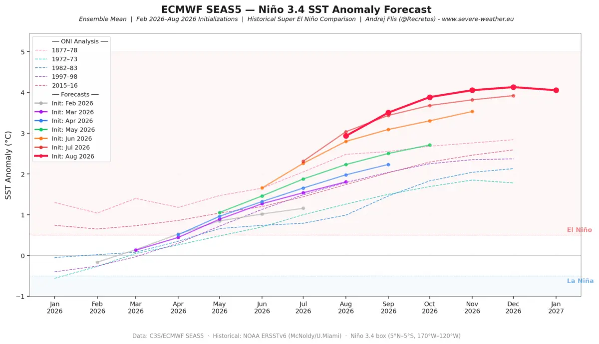
As meteorological agencies and long-range forecasters look ahead to the cold-weather season, all eyes are locked on the equatorial Pacific Ocean. Winter 2026/2027 is rapidly shaping up around a powerful, potentially record-breaking Super El Niño. Latest seasonal modeling from premier global weather centers—including the European Centre for Medium-Range Weather Forecasts (ECMWF) and the National Oceanic and Atmospheric Administration (NOAA)—indicates a highly amplified, split-flow atmospheric pattern that will dictate weather extremes across North America and Europe.

Main Facts: The Anatomy of a Super El Niño
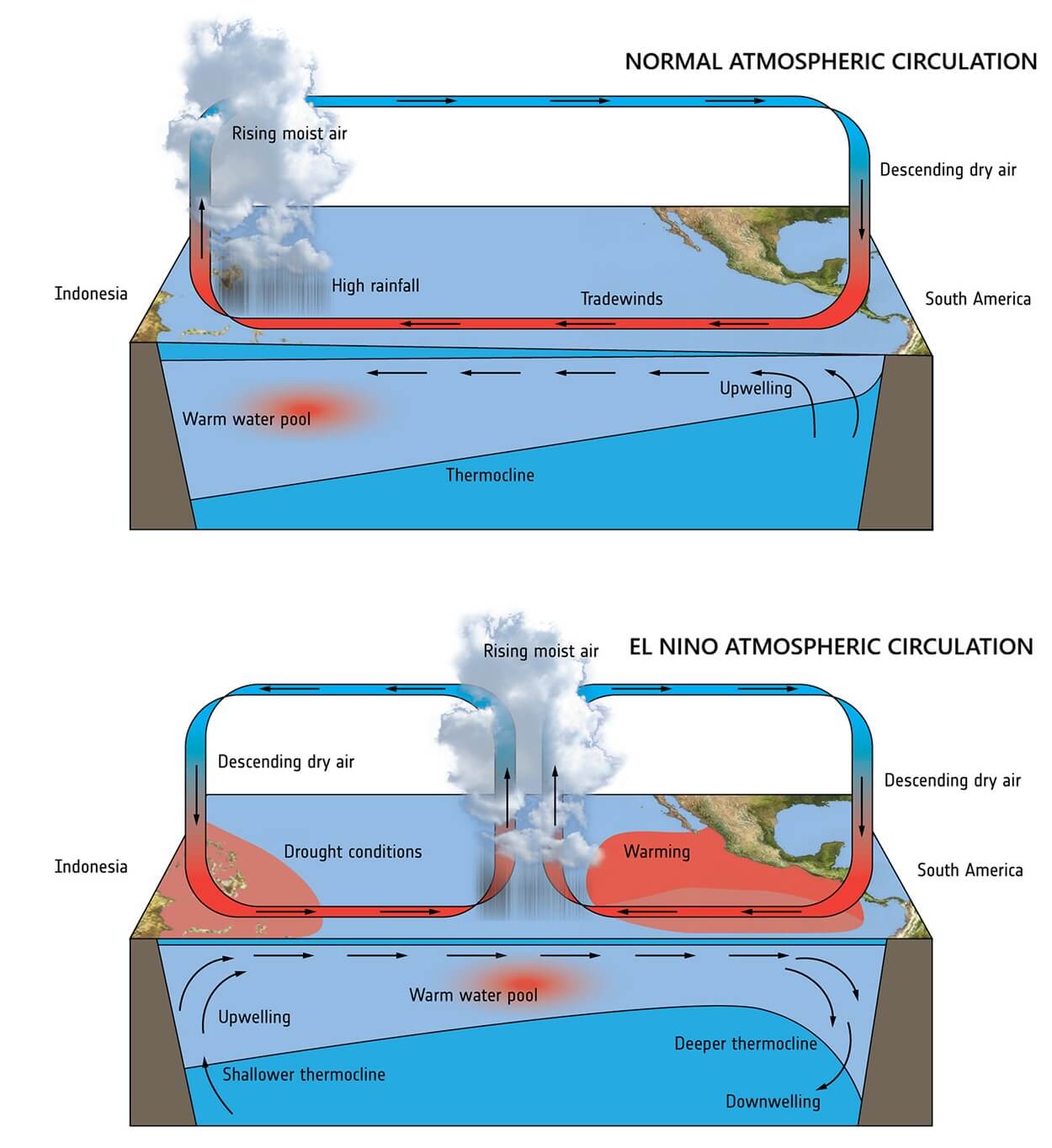
The defining driver of the upcoming winter is an exceptionally robust El Niño event currently tracking well within Super-to-Extreme thresholds. Characterized by anomalously warm sea surface temperatures in the central and eastern tropical Pacific, this phenomenon triggers sweeping alterations in global atmospheric circulation via the Walker Cell.
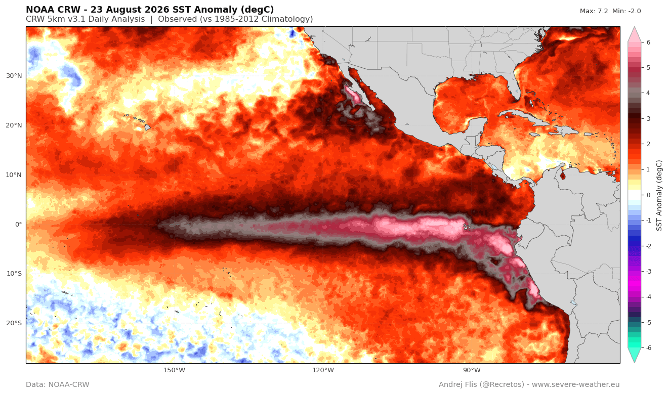
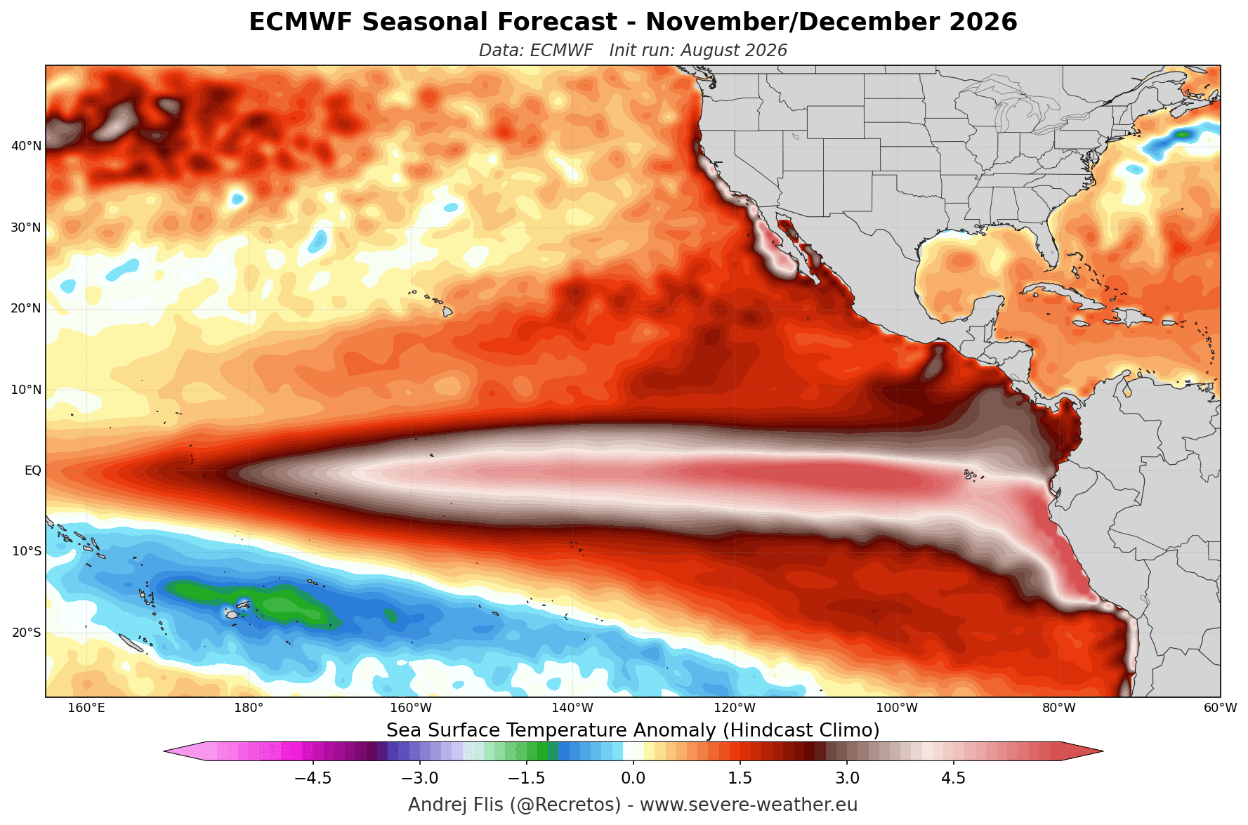
- Unprecedented Ocean Heat: NOAA Coral Reef Watch (CRW) data highlights massive warm anomalies exceeding +6°C (11°F) above normal across broad swathes of the tropical Pacific. Sustained seasonal ENSO values have already surpassed the +2°C threshold required for a Super El Niño declaration.
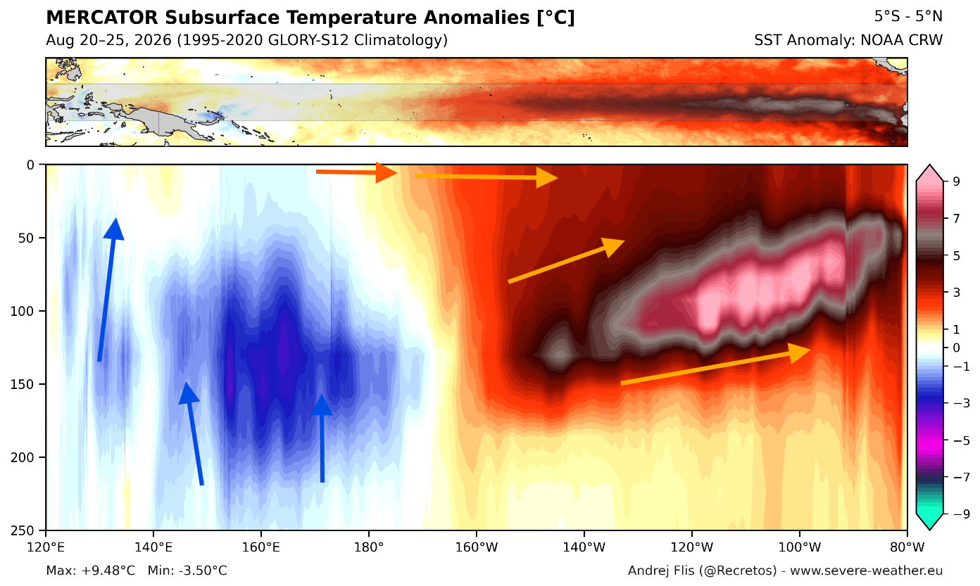
- The Kelvin Wave Engine: Subsurface temperature cross-sections reveal a massive downwelling Kelvin Wave in the upper 250 meters (800 feet) of the Pacific, featuring core anomalies more than 9°C (16°F) above average. This serves as the engine, continuously feeding energy into the surface ocean layer and ensuring persistent atmospheric forcing throughout the winter months.
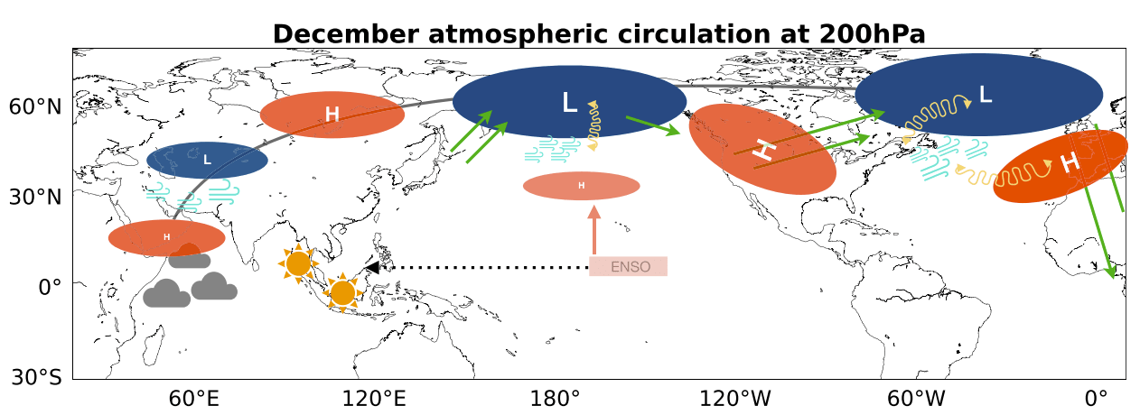
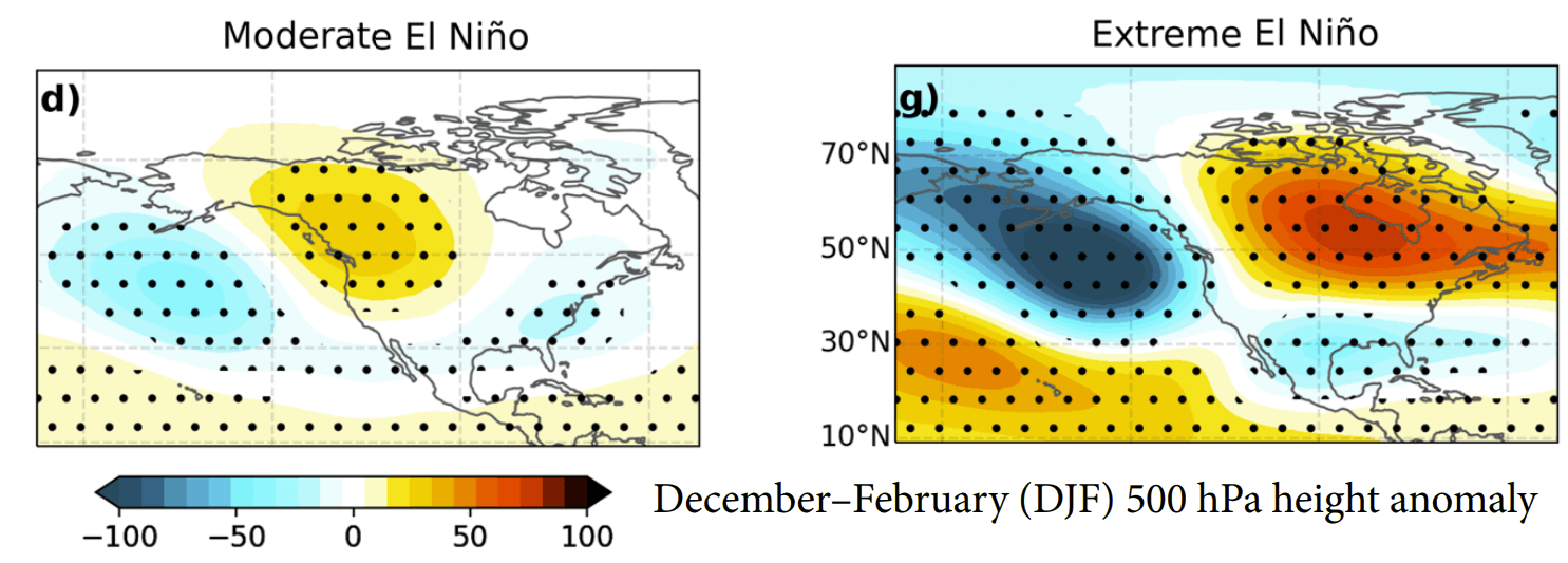
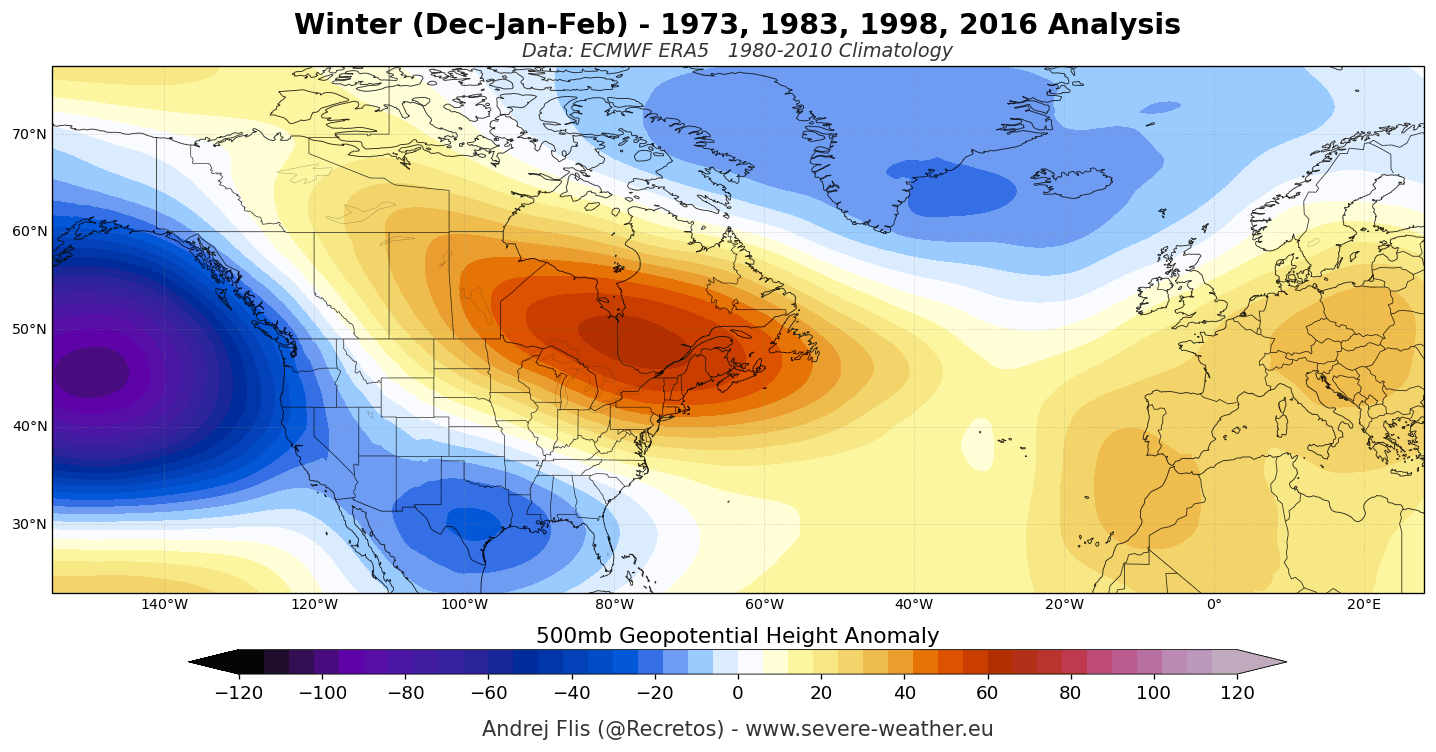
- North American Split-Flow: The atmospheric response features a deeply anchored low-pressure trough over the North Pacific, a massive blocking high-pressure ridge over Canada, and an active southern storm track across the United States.
- European Westerlies: Across the Atlantic, the dominant driver points toward an active, mild westerly and southwesterly flow that will dictate temperature and precipitation regimes across mainland Europe.
Chronology: From Summer Heat to Mid-Winter Amplification
The evolution of the 2026/2027 winter pattern follows a distinct chronological timeline, tracing back to oceanic changes observed earlier in the year and projecting through the core of the cold season.
Late Summer and Fall 2026: Subsurface Build-up
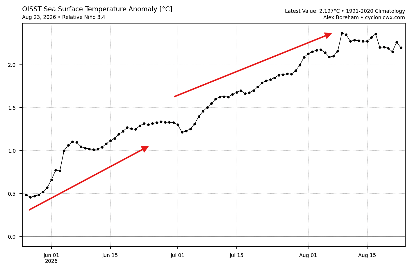
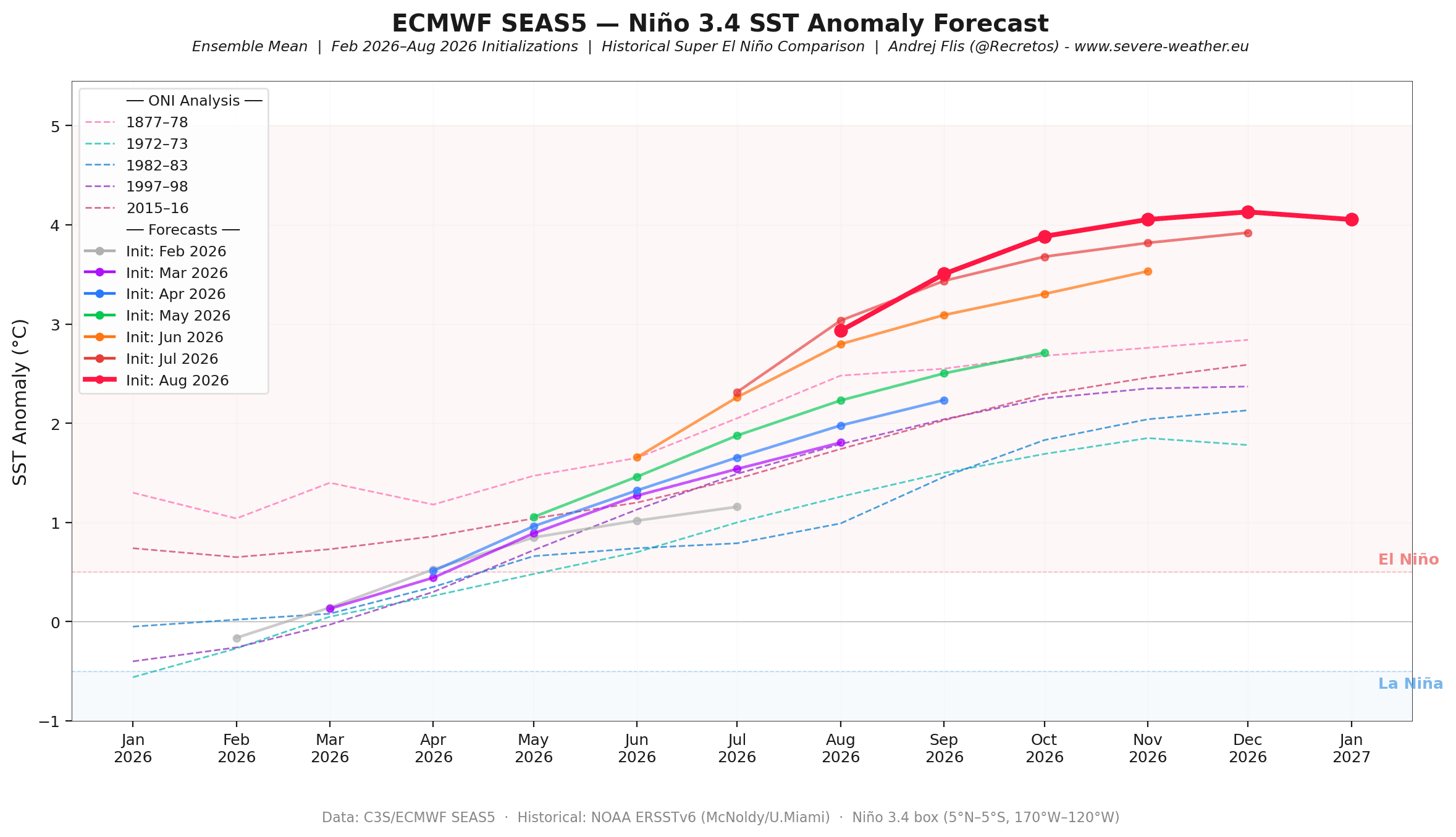
Throughout the summer and early fall, rapid continuous anomaly increases were recorded by OISST monitoring systems. Westerly wind bursts displaced warm upper-ocean waters eastward, fueling the expansive Kelvin Wave. Major forecast systems, notably ECMWF’s SEAS5 runs, continuously adjusted their projections upward, pushing the anticipated peak anomaly into record-strong territory for November and December.
December 2026: Pattern Initialization
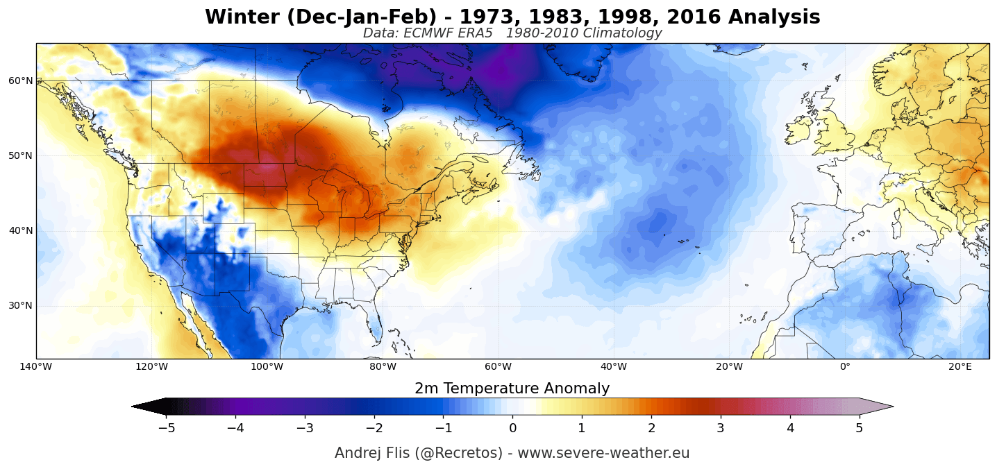
As meteorological winter begins, the planetary Rossby wave train initiates. The jet stream divides. Canada and the northern tier of the United States experience an influx of mild, stable air beneath the growing high-pressure ridge. Simultaneously, the southern U.S. and Gulf Coast transition into a cooler, cloudier, and wetter regime governed by the southern branch of the jet stream.
January 2027: Polar Vortex Disruption and Deepening Anomalies
Mid-winter introduces a critical secondary driver: the stratospheric Polar Vortex. Both ECMWF and UKMO models indicate an unusual deceleration of stratospheric zonal winds around late December and January. While not a direct prediction of a Sudden Stratospheric Warming (SSW) event weeks in advance, this early disruption signal suggests a weakened vortex capable of amplifying lower-atmospheric pressure patterns. Consequently, January weather charts reveal a sharp reinforcement of the Pacific low-pressure anomaly and a widening north-south temperature divide.
February 2027: Peak Pattern Maturation
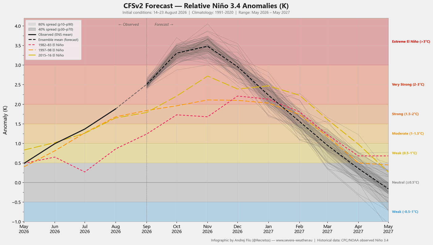
By late winter, multi-model ensembles from the North American Multi-Model Ensemble (NMME) and NCEP CFSv2 project a deeply entrenched blocking high over Canada paired with a highly active southern and eastern U.S. low-pressure corridor. This mature configuration increases the statistical likelihood of colder air outbreaks interacting with moisture-rich southern storms across the central and eastern United States.
Supporting Data: Model Convergence and Historical Analogs
To validate these long-range projections, meteorologists rely on multi-model consensus and historical composites derived from past Super El Niño events (such as those in 1982–83, 1997–98, and 2015–16).
Model Consensus: ECMWF vs. NMME
The ECMWF seasonal forecast for December through February outlines a textbook Super El Niño pressure footprint: deep North Pacific troughing, Canadian blocking, and an extended Pacific jet stream stretching toward Europe. This output is independently reinforced by the NOAA NMME system, which merges multiple North American and Canadian model predictions to show near-identical temperature and precipitation anomalies. The high degree of cross-model agreement significantly elevates confidence in the large-scale forecast.
Historical Snowfall and Temperature Composites
ERA5 reanalysis data from past Super El Niño winters provides clear clues regarding regional impacts:
- United States: Above-normal snowfall is historically concentrated across the Sierra Nevada, the Four Corners, the Southern Rockies, and parts of the Central Plains. Conversely, the Pacific Northwest, Great Lakes, Ohio Valley, and Northeast typically experience pronounced snowfall deficits due to suppressed northern storm tracks and mild Canadian air intrusions.
- Europe: Historical composites show widespread winter snowfall deficits across lowlands and mid-elevations driven by the relentless Atlantic westerly flow. Positive snow anomalies are generally restricted to northern latitudes and high-altitude European mountain ranges (such as the Alps above 1,800–2,000 meters), where temperatures remain sufficiently low.
Official Responses and Industry Implications
The projected severity of the 2026/2027 Super El Niño carries significant implications for various economic sectors, municipal planning, and regional resource management.
Agriculture and Water Management
- Western United States: Heavy precipitation and snowpack accumulation across California and the Southwest will significantly boost water reservoirs, though municipal planners must remain vigilant against localized flooding and mudslides in burn-scar areas.
- Southern U.S. Agriculture: Persistent damp conditions driven by the active subtropical jet stream will impact winter crop management, requiring adjustments in planting and harvesting schedules across the Gulf Coast and Southeast.
Winter Tourism and Ski Resorts
- North America: A stark division awaits winter sports enthusiasts. Resorts in California, Utah, and the Central-to-Southern Rockies anticipate robust snowpacks and favorable conditions. Meanwhile, operators in the Pacific Northwest, the Northern Rockies, and parts of New England face challenging conditions characterized by below-average natural snowpack and higher reliance on artificial snowmaking.
- Europe: European ski resorts will face an elevation-dependent season. While low-to-mid elevation resorts in the Pyrenees and Apennines may struggle with warm, moist Atlantic air, high-altitude alpine destinations in the central and western Alps are positioned to capture substantial snowfall from moisture-laden westerly systems.
Broader Implications: The Atmospheric Bridge
The 2026/2027 winter season serves as a prime textbook example of the "atmospheric bridge"—the mechanism by which tropical ocean anomalies reorganize global weather patterns thousands of miles away. By pumping immense amounts of thermal and wave energy into the troposphere and stratosphere, the developing Super El Niño transcends a localized oceanic event, fundamentally altering the jet stream architecture of the Northern Hemisphere.
As winter approaches, forecasters will continue to monitor the exact timing of the stratospheric Polar Vortex deceleration and its potential to unlock mid-latitude cold-air outbreaks. For communities across North America and Europe, preparation for a high-energy, highly contrasted winter season is already underway.
