

Every autumn, weather forums, social media channels, and long-range forecasting blogs buzz with the same recurring question: Is snow spreading rapidly across Siberia? For over a decade, a large segment of the meteorological community and weather enthusiast circle has treated a swift October snow advance across Eurasia as a premier harbinger of a harsh, bitter winter for the United States, Canada, and Europe.
This widely shared concept stems from a foundational 2011 scientific study. Ever since, it has been dusted off and repeated like clockwork ahead of nearly every winter season. With another fast snow surge forecast across the region, a comprehensive new investigation was launched to test whether this famous indicator still holds water in the modern era. Analyzing 47 winters of data spanning from 1979 to 2025 across four distinct snow datasets—including the exact satellite metrics used in the original research—reveals surprising conclusions. The findings challenge how we interpret October snow cover, how the stratosphere interacts with the surface, and what we should realistically expect for the upcoming Winter 2026/2027.
Chronology of a Theory: How October Snow Grew Into a Winter Indicator
The 2011 Discovery
In 2011, researchers Judah Cohen and Justin Jones published a groundbreaking study identifying a notable teleconnection in the Northern Hemisphere. They measured the rate at which snow cover expanded across Eurasia during October and evaluated its subsequent impact on the winter season. According to their findings, a faster advance of Eurasian snow cover correlated strongly with an increased likelihood of disruptive Arctic air outbreaks penetrating deep into the mid-latitudes of North America and Europe.
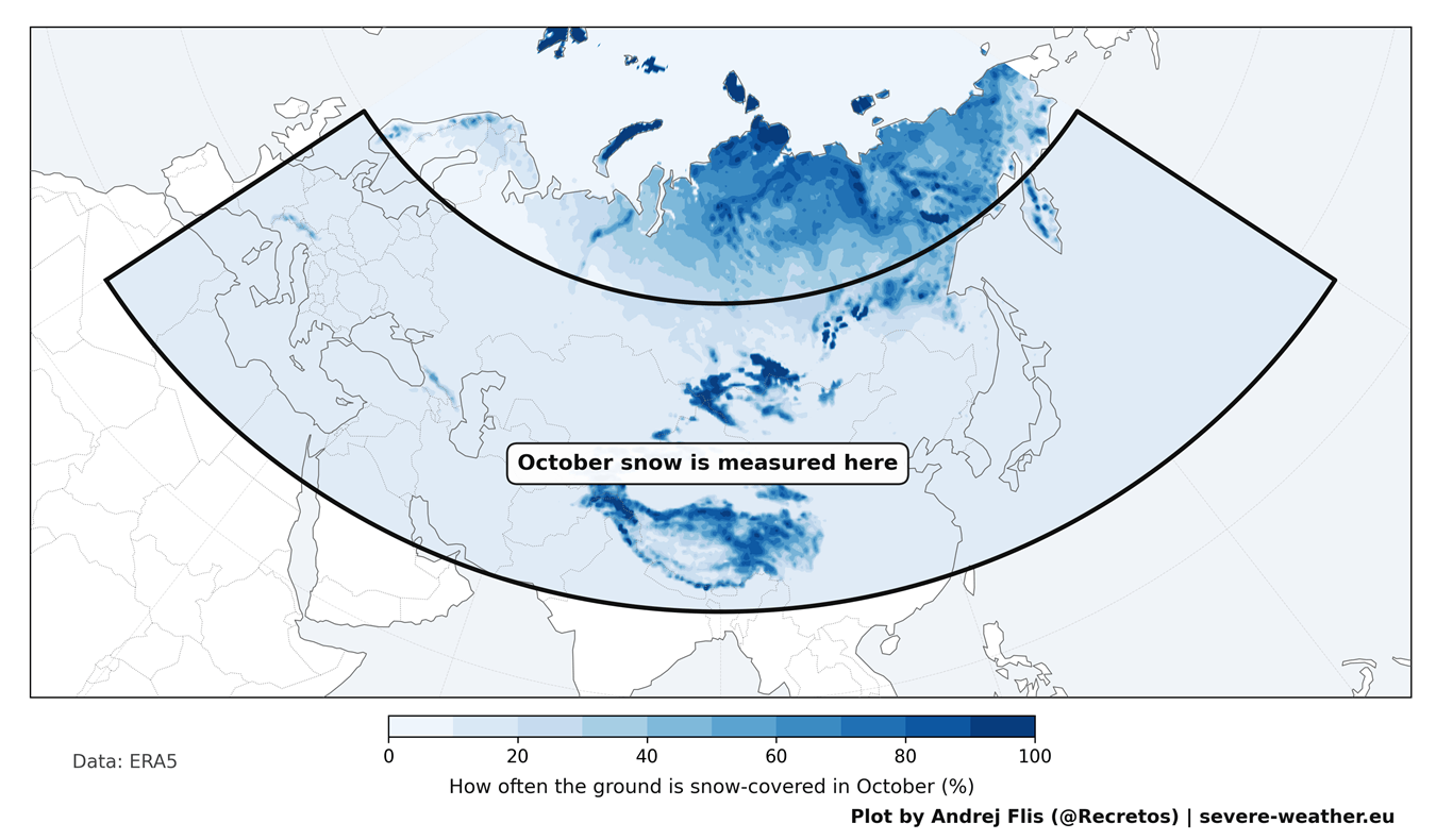
The geographical footprint of this study is immense, spanning from Western Europe to the Pacific coast of Russia. The bulk of this October snow accumulates across southern Siberia, Mongolia, and the elevated terrains of Central Asia and the Tibetan Plateau.
The Physical Mechanism
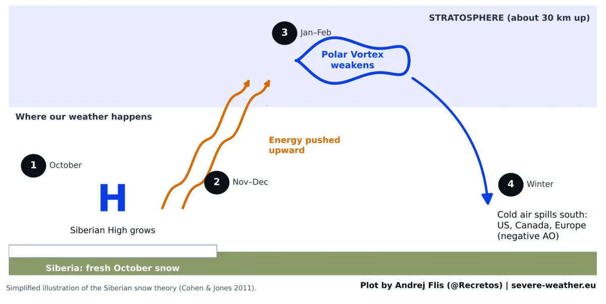
The underlying physics of the theory appear robust. Fresh snow cover dramatically cools the ground surface, strengthening the Siberian High—a sprawling, semi-permanent area of cold, dense high pressure over northern Asia. This robust surface high-pressure anomaly pumps excess wave energy vertically into the stratosphere, roughly 18 to 30 kilometers (11 to 18.5 miles) above the Earth’s surface.
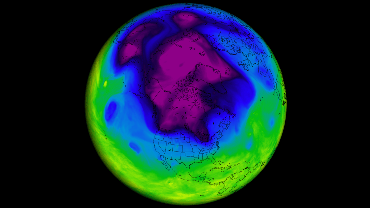
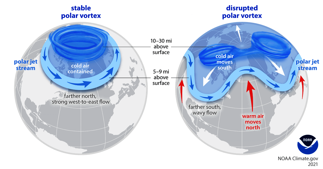
Once this upward-propagating energy reaches the stratosphere, it disrupts the Polar Vortex: a massive, ring-like barrier of strong westerly winds that normally bottles up the core of the Arctic’s deep freeze.
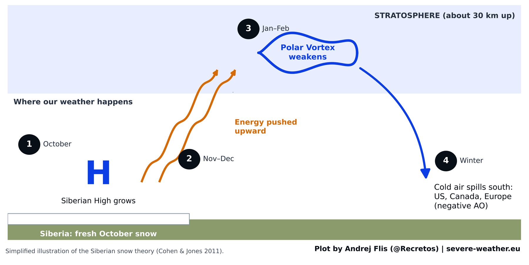
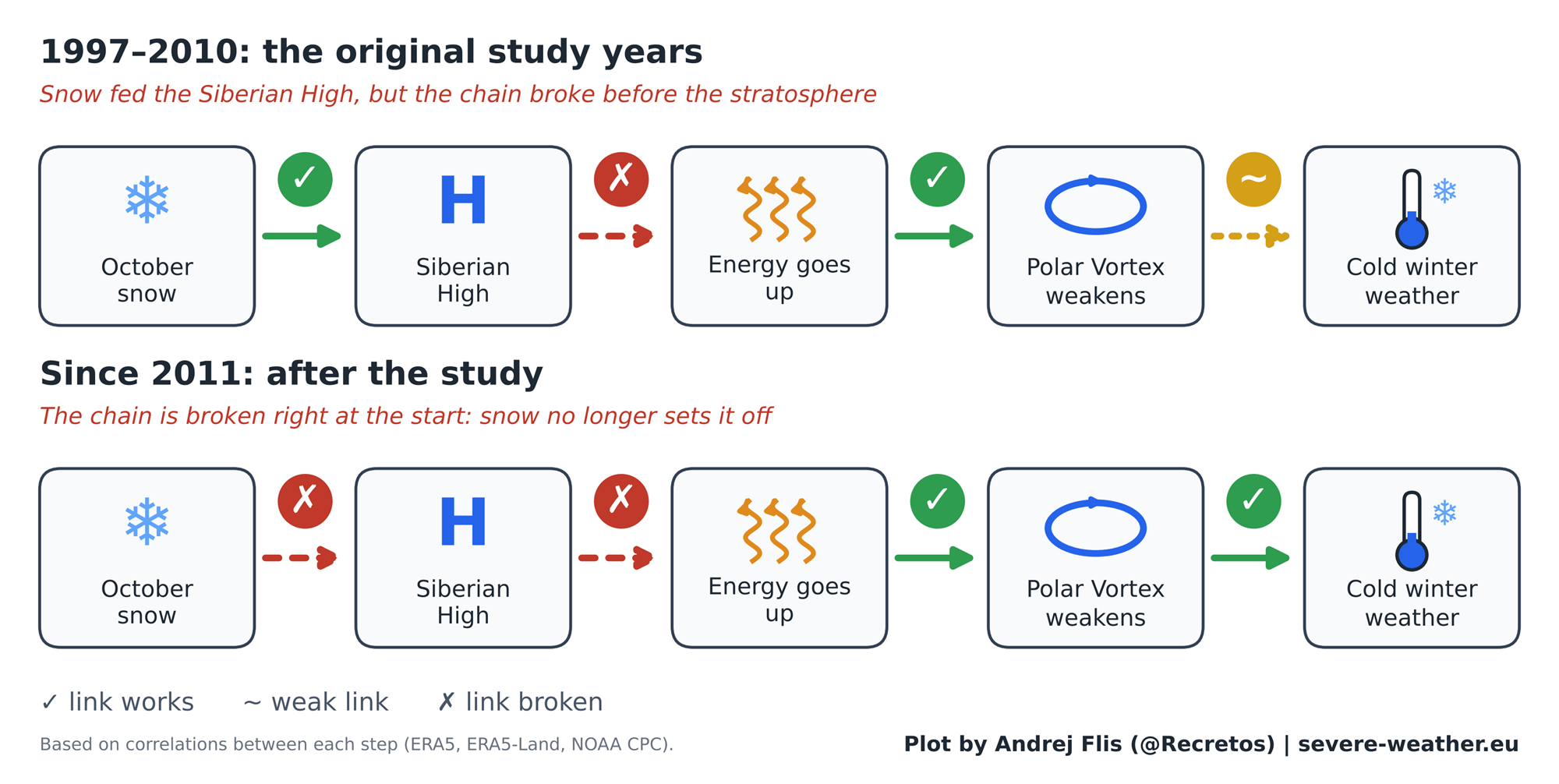
The theory relies on a delayed, multi-step chain reaction:
- Surface: Rapid October snow buildup strengthens the Siberian High.
- Troposphere to Stratosphere: Enhanced energy propagates upward into the polar stratosphere.
- Stratosphere: The Polar Vortex weakens, stretches, or destabilizes.
- Troposphere Return: The disrupted vortex forces a negative phase of the Arctic Oscillation (AO), allowing lobes of bitter Arctic air to spill southward.
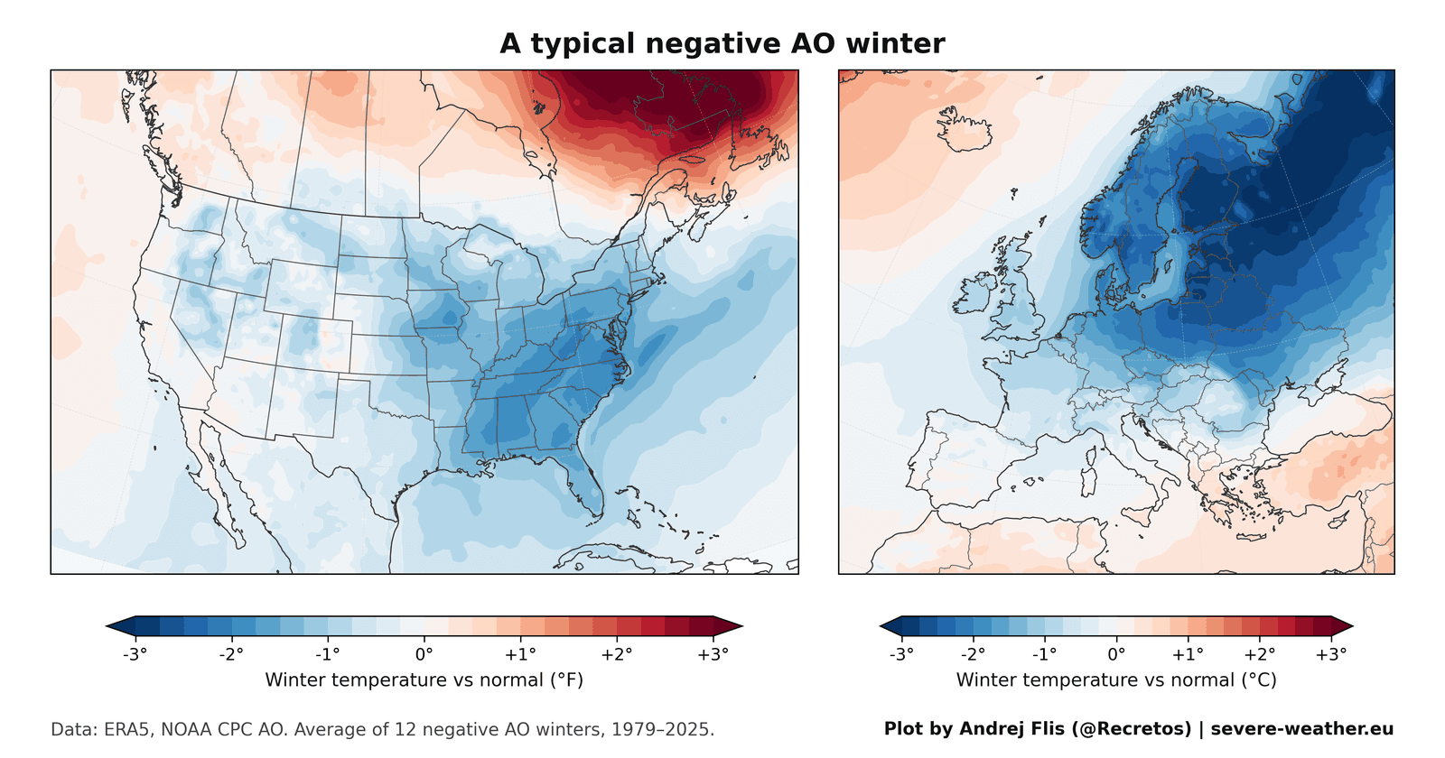
When the Arctic Oscillation turns negative, the statistical probability of major cold air outbreaks over the eastern United States, northern Europe, and the UK surges dramatically. Conversely, a positive AO locks the coldest air securely near the pole, fostering milder winter conditions across the mid-latitudes.
Supporting Data: Putting 47 Winters Under the Microscope
While the theory gained immense popularity between 1997 and 2010, the original study had an inherent limitation: daily satellite snow maps only extended back to 1997, leaving researchers with a baseline of just 14 winters.
To conduct a modern, rigorous stress-test, meteorologists expanded the dataset to encompass 47 winters (1979–2025), specifically isolating the 15 winters that have occurred since the study’s publication. To ensure absolute data integrity, four independent snow datasets were cross-referenced, ranging from high-resolution satellite observations to modern meteorological reanalysis models.
The Signal Fades Over Time
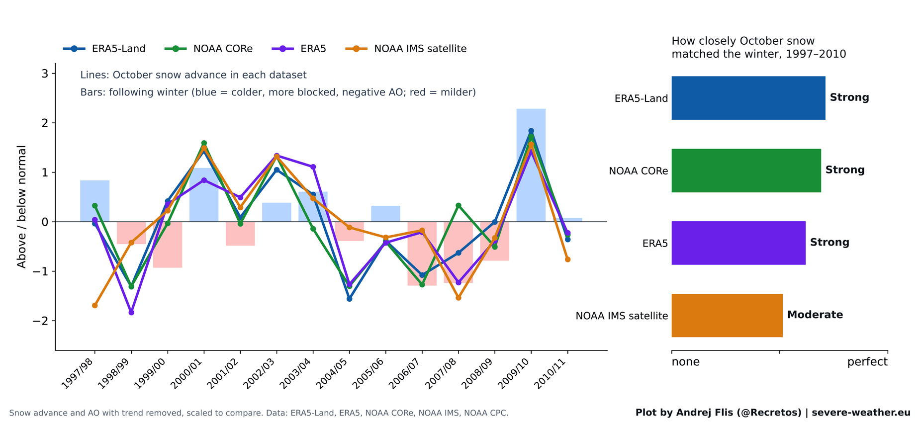
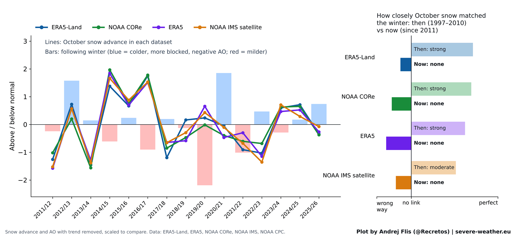
When examining the original 1997–2010 window, the data validated the original researchers’ findings: every dataset confirmed a statistically significant link between October snow cover and the subsequent winter AO index. The original scientists had not made an analytical error.
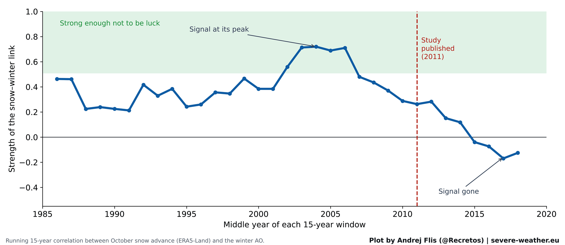
However, tracking the strength of this correlation over rolling 15-year windows reveals a stark decline. The predictive signal peaked sharply in the early-to-mid 2000s—precisely when the original study was being formulated. Since 2011, the signal has steadily eroded, eventually inverting into a neutral or slightly negative correlation. When evaluated across all 15 winters since the 2011 publication, the four snow datasets unanimously agree: the predictive snow-to-AO winter signal has effectively vanished.
A Statistical Coin Toss
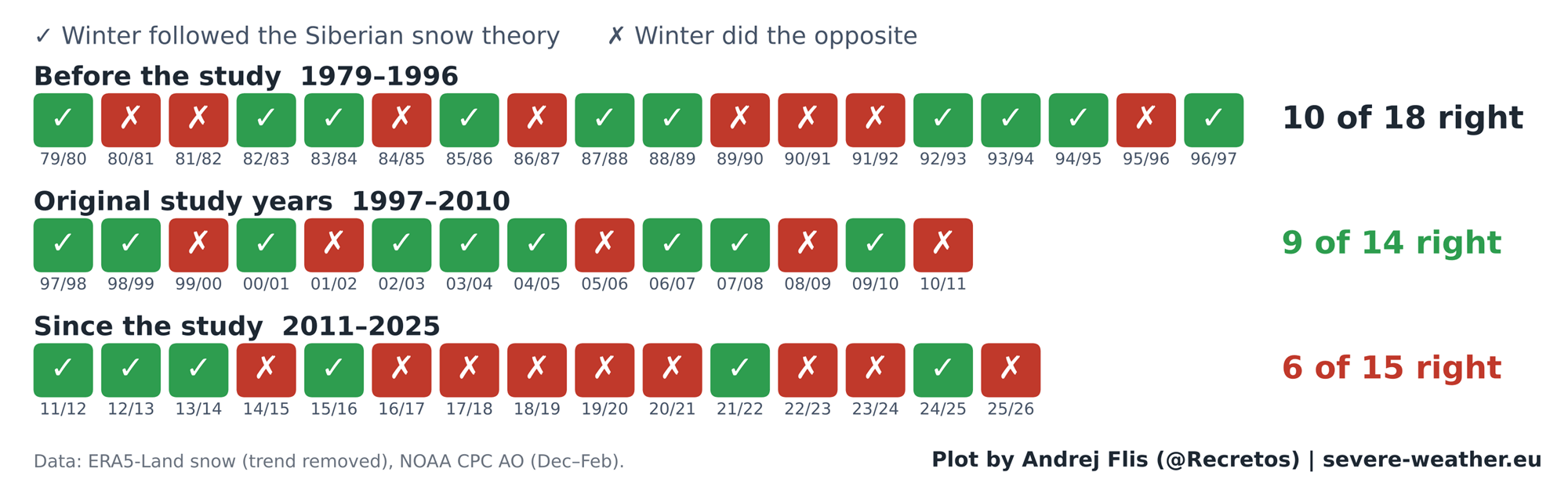
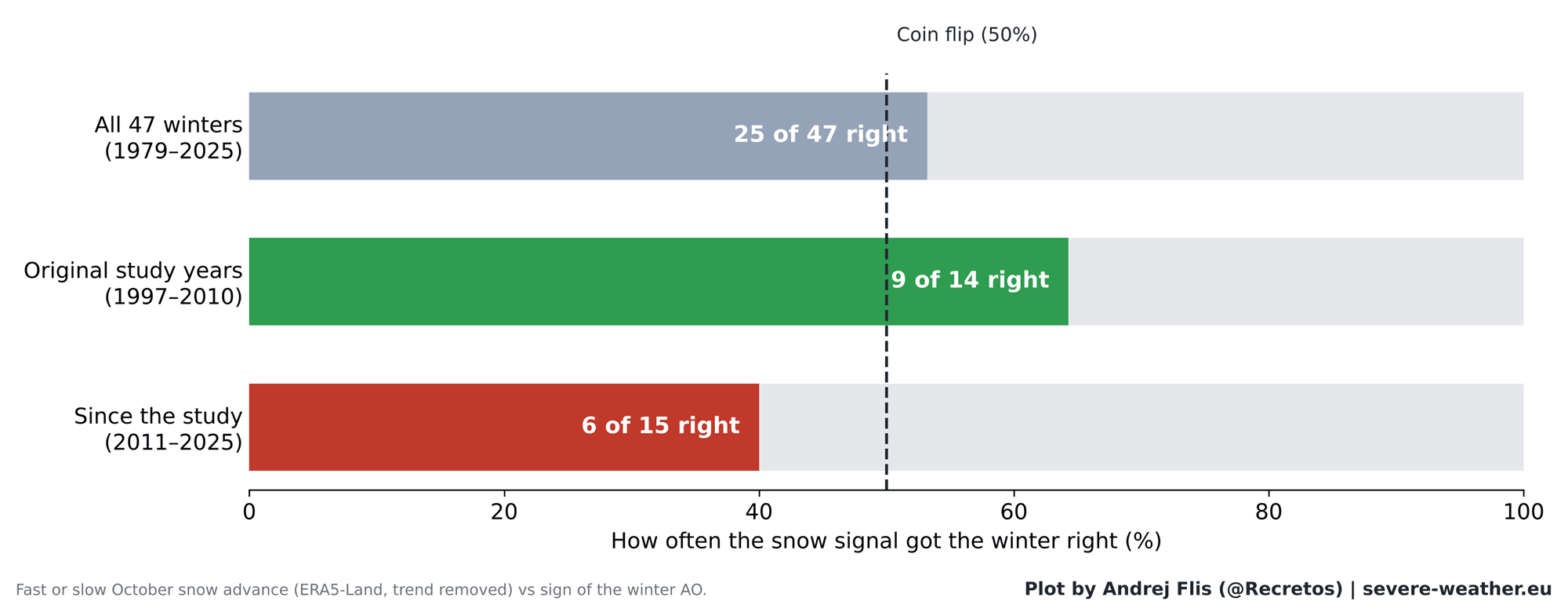
Reviewing the performance winter-by-winter across all 47 years yields sobering results for long-range forecasters:
- Overall Score (1979–2025): Correct 25 times, incorrect 22 times (a 53% success rate—essentially a statistical coin flip).
- Original Study Period (1997–2010): Correct 9 out of 14 times.
- Post-Study Period (2011–2025): Correct only 6 out of 15 times (worse than random chance).
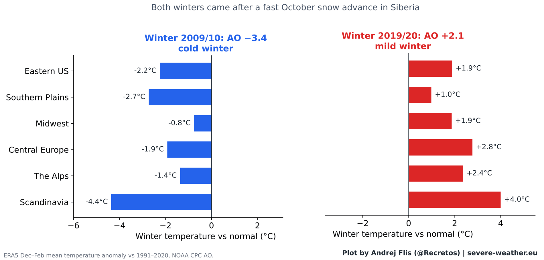
Why did the theory look so bulletproof in 2011? The answer largely lies in the historic Winter of 2009/2010. That winter followed one of the most rapid October snow advances on record and culminated in the most negative AO phase recorded up to that time, delivering relentless cold to Europe and legendary blizzards across the Eastern United States in February 2010. That single, high-profile mega-winter cemented the theory in the public consciousness.
Conversely, anomalies occur in the opposite direction. The Winter of 2019/2020 also followed an aggressively fast October snow advance, yet it materialized as one of the most strongly positive AO winters on record, bringing exceptionally mild, snow-free conditions to both Europe and large parts of the United States.
The Breakdown: Why Did the Chain Reaction Fail?
Dissecting the atmospheric chain reaction step-by-step highlights precisely where the breakdown occurs.
The latter half of the physical chain remains rock-solid: when anomalous wave energy successfully propagates upward into the stratosphere during November and December, the Polar Vortex unfailingly weakens during January and February, triggering downstream winter weather shifts. This is established, immutable atmospheric physics.
The weak link resides entirely at the inception point. While October snow was once believed to reliably amplify the Siberian High and drive upward wave energy, that initial surface-to-stratosphere conduit has degraded. In recent decades, Siberian snow cover no longer triggers consistent upward energy surges. Rapid Arctic sea-ice loss, shifting ocean temperatures, and broader climate changes have fundamentally altered how the high-latitude atmosphere responds to autumn surface conditions.
Implications for Winter 2026/2027: A Super El Niño Takes Center Stage
As attention turns toward the upcoming Winter 2026/2027, Eurasian snow cover started October at a slightly sluggish pace relative to climatological norms. However, ECMWF ensemble forecasts indicate a sharp, aggressive snow surge during the final weeks of October, pushing the monthly accumulation rate comfortably into the top 15% of historical observations for this time frame.
Historically, the six past Octobers exhibiting the most similar snow advance trajectories produced wildly divergent winter outcomes: three negative AO winters, one neutral winter, and two positive AO winters. Clearly, relying on Siberian snow cover alone offers little reliable guidance for the upcoming season.
The Super El Niño Factor
Instead of looking to Siberia, meteorologists are focusing on a far more dominant force shaping the global climate system for Winter 2026/2027: an exceptionally robust Super El Niño currently dominating the equatorial Pacific Ocean.
Extensive observational and modeling data confirm that strong El Niño events exert a profound, statistically verifiable deceleration effect on the stratospheric Polar Vortex during mid-to-late winter. Seasonal forecasts from the ECMWF project that zonal winds within the stratosphere will plummet well below long-term normal values by January 2027, signaling a high probability of a disrupted Polar Vortex or a major Sudden Stratospheric Warming (SSW) event.
When a major stratospheric warming event or vortex collapse occurs, climatological statistics indicate that an increased risk of severe, sustained cold air outbreaks shifts toward the central and eastern United States, alongside northern and central Europe.
Regional Temperature Outlooks
- United States: The ECMWF forecast for mid-to-late winter 2026/2027 highlights a classic Super El Niño configuration. An amplified southern jet stream and active storm track point toward persistent cloud cover, increased precipitation, and cooler-than-average temperature anomalies across the southern, central, and eastern United States, contrasting with milder conditions across the far northern tier.
- Europe: Current seasonal projections for Europe lean toward a predominantly milder westerly flow into the continent, with true cold anomalies largely restricted to far northern Scandinavia. Unless late-season stratospheric shifts alter European blocking patterns, the primary target for mid-winter cold air releases leans toward North America.
Official Responses and Methodological Notes
As long-range forecasting continues to evolve, atmospheric scientists emphasize the necessity of discarding oversimplified, single-variable proxies in favor of holistic, multi-factor modeling.
An important methodological caveat was uncovered during this multi-dataset research: standard ERA5 reanalysis data exhibits an artificial, sudden 40% drop in Eurasian October snow cover around 2004, stemming from the integration of early satellite snow-mapping algorithms. Cross-referencing alternative datasets—including ERA5-Land, NOAA CORe, and IMS satellite products—confirmed that this artifact was isolated to ERA5’s lowland Siberian datasets and did not compromise the overarching statistical conclusions of this study.
Ultimately, while the romantic idea of tracking Siberian snow to predict holiday and mid-winter weather makes for compelling folklore, modern data proves it is no longer a dependable forecasting tool. For Winter 2026/2027, forecasters will monitor real-time stratospheric heat fluxes and the commanding influence of the record-challenging Super El Niño to chart the true course of the upcoming season.
