

Every autumn, as the first chills of winter begin to sweep across the Northern Hemisphere, a familiar narrative resurfaces across weather forums, meteorological blogs, and social media channels. The premise is simple yet captivating: does a rapid, early-season surge of snow across Siberia serve as a crystal ball for the upcoming winter? For over a decade, weather enthusiasts have treated a fast October snow advance across Eurasia as a definitive early warning sign for a harsh, bitterly cold, and snowy winter season across the United States, Canada, and Europe.
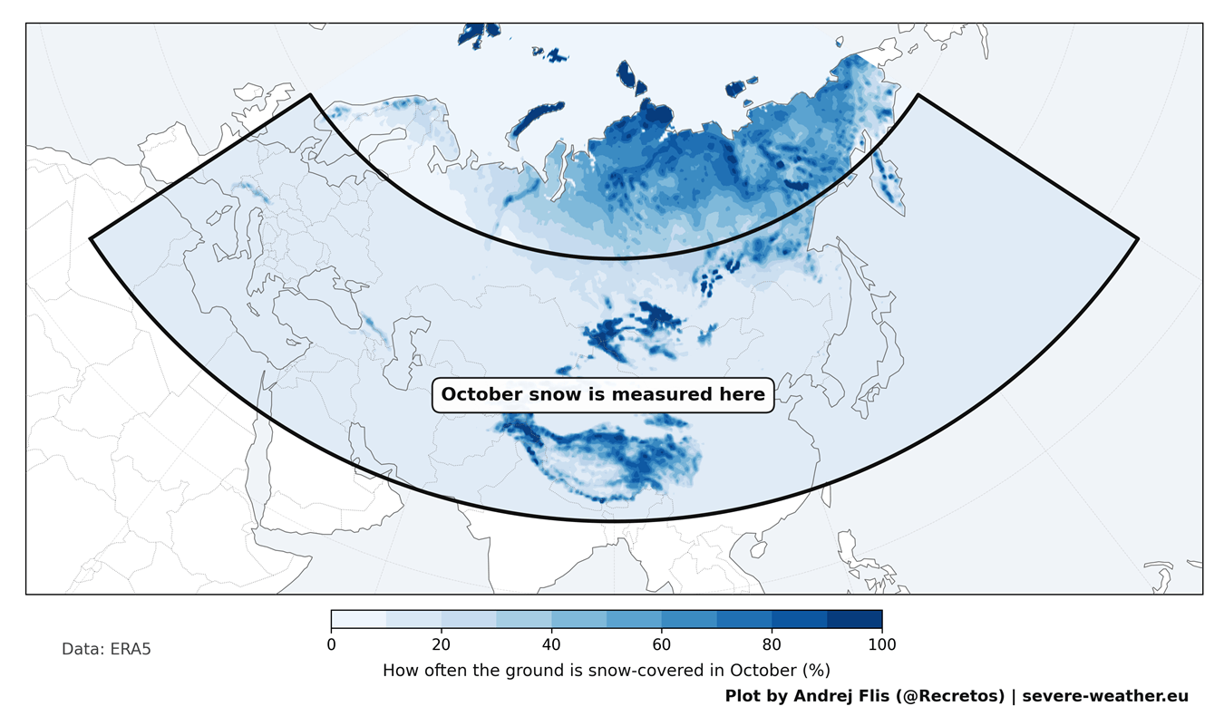
This enduring hypothesis traces back to a landmark 2011 scientific study that hypothesized a delayed atmospheric chain reaction originating from the Siberian surface and rippling all the way up into the stratosphere. With another aggressive Eurasian snow forecast taking shape this October, a comprehensive empirical investigation was launched to test the theory’s validity in the modern era. Analyzing 47 winters of historical data spanning from 1979 to 2025 across four distinct, high-resolution snow datasets—including the exact satellite observations utilized in the foundational research—revealed surprising results.
The findings not only challenge how meteorologists and enthusiasts should interpret early-season snow cover data but also provide a clearer picture of what the latest long-range atmospheric and oceanic indicators portend for the approaching Winter 2026/2027.
Main Facts: Deconstructing the Siberian Snow Theory
The concept that October snow cover in Eurasia dictates mid-latitude winter weather is rooted in established thermodynamic principles. In 2011, researchers Judah Cohen and Justin Jones identified a statistical link between the rate of snow expansion across Eurasia during October and the subsequent behavior of the Polar Vortex during the core winter months.
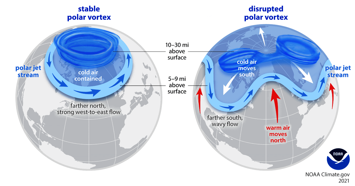
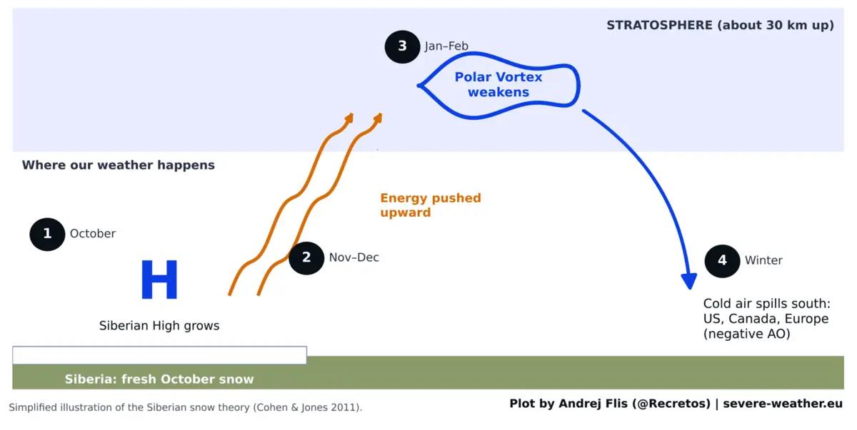
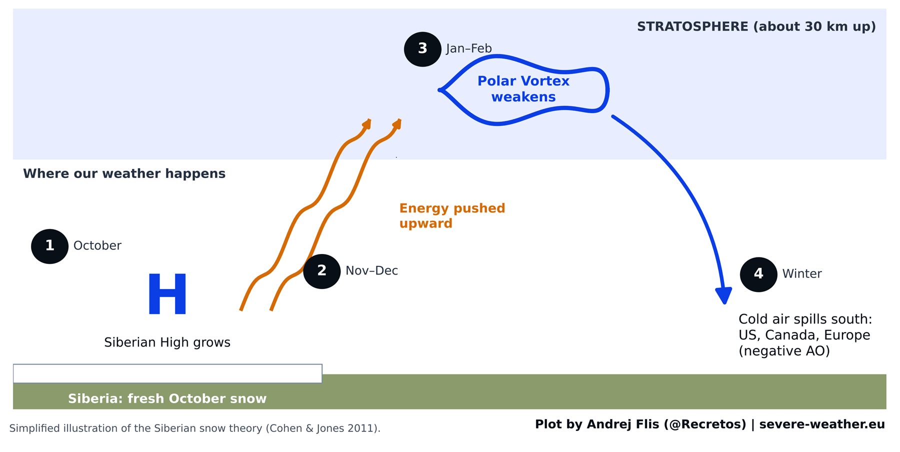
The Theoretical Chain Reaction
- Surface Cooling: Fresh, expansive snow cover sharply cools the overlying ground, dramatically increasing surface albedo and enhancing radiative heat loss.
- Pressure Strengthening: This intense surface cooling reinforces the Siberian High, a massive semi-permanent pool of cold, dense air centered over northern Asia.
- Stratospheric Wave Energy: The strengthened Siberian High acts as a dynamic engine, pumping increased planetary wave energy vertically upward into the stratosphere, roughly 18 to 30 kilometers above the surface.
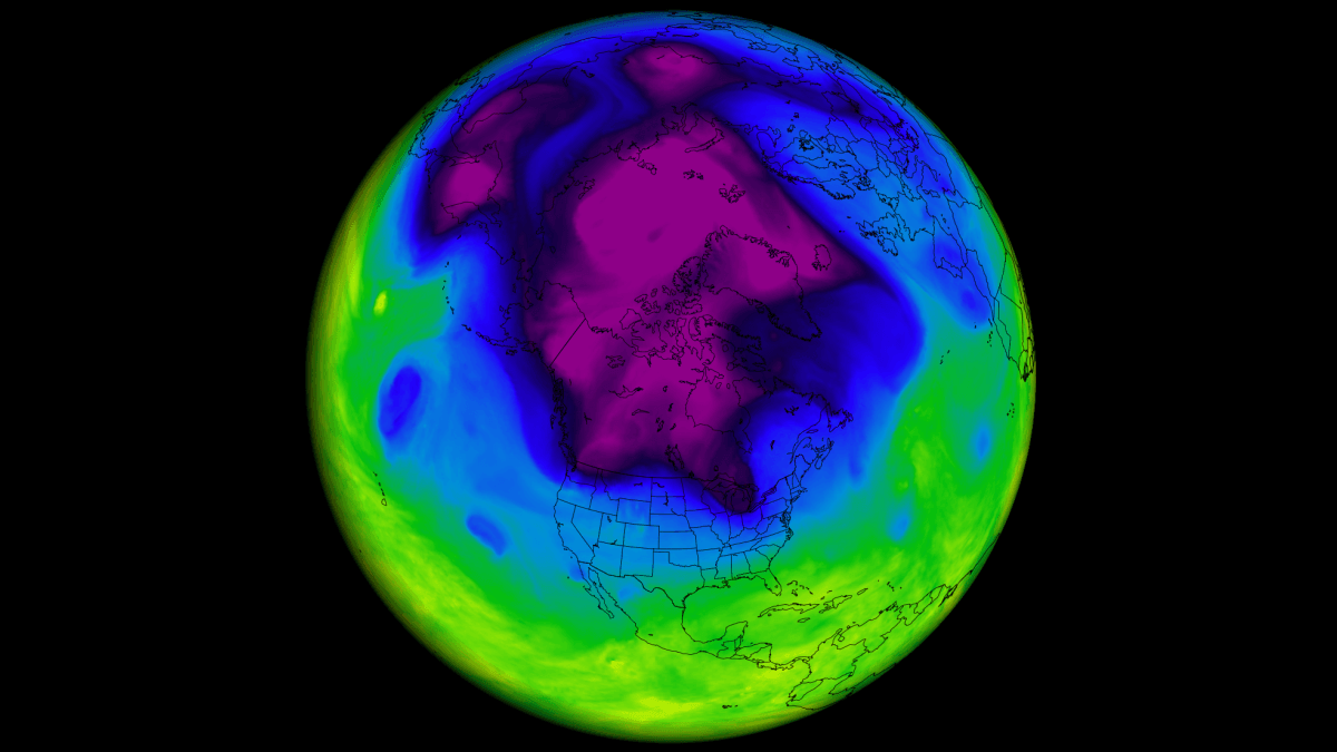
- Polar Vortex Disruption: This upward flux of energy disrupts the stratospheric Polar Vortex—a ring of fierce westerly winds that normally bottles up frigid Arctic air. When the vortex becomes stretched, distorted, or destabilized, lobes of extreme cold break away, spilling southward into North America and Eurasia.
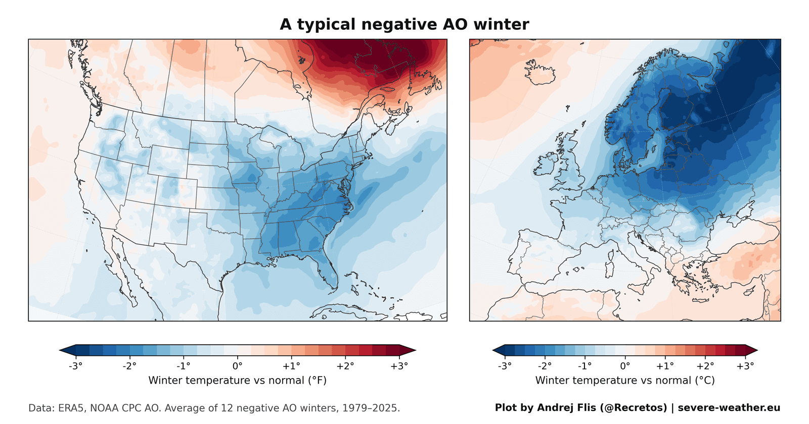
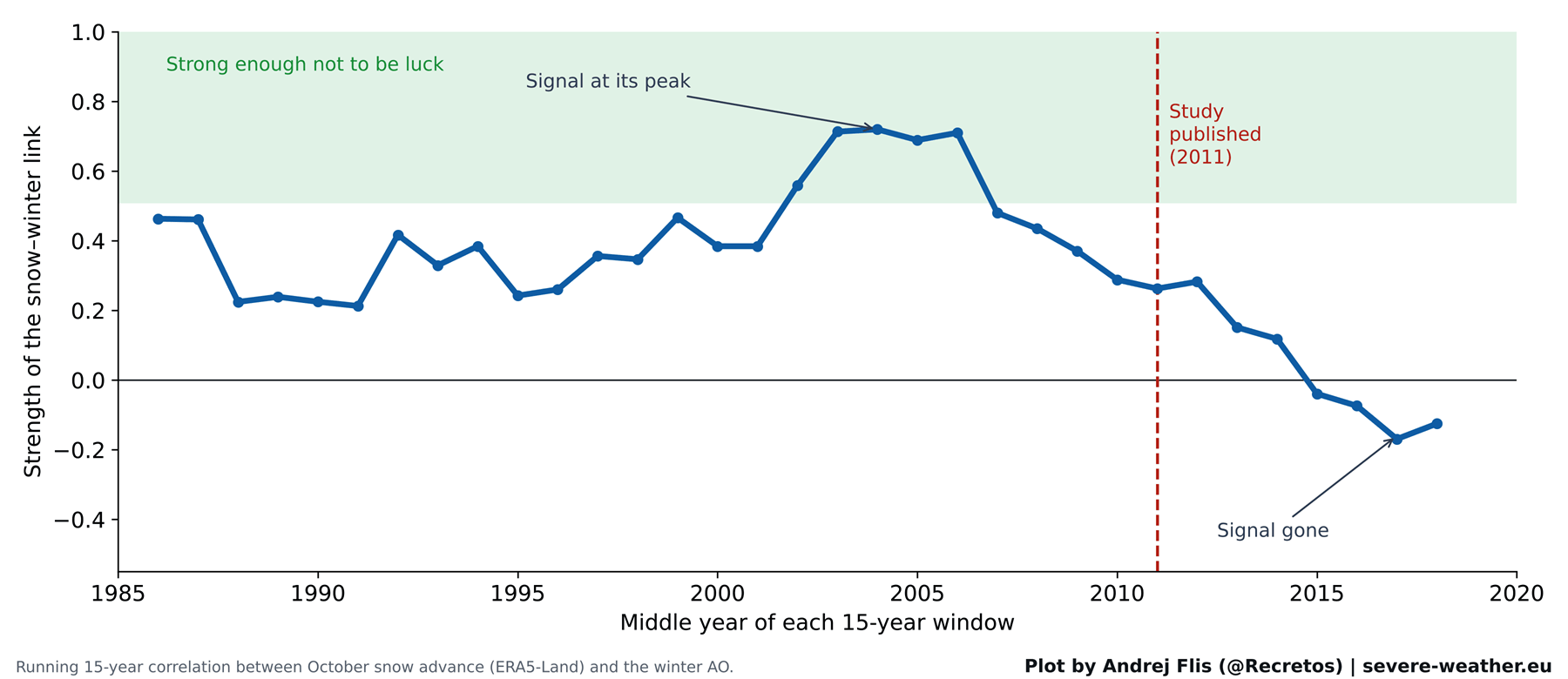
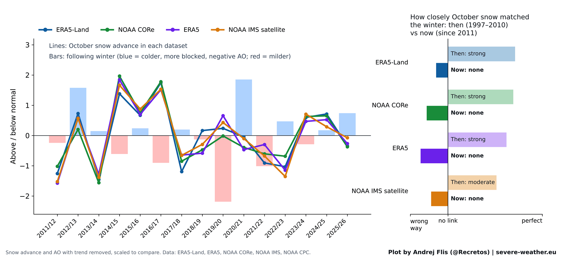
When tracked using the Arctic Oscillation (AO) index, a negative AO phase facilitates these southward plunges of Arctic air. Historically, a fast October snow advance was believed to reliably trigger this sequence, favoring severe winters in the eastern United States and northern Europe. However, a rigorous re-examination of 47 winters of data reveals that this predictive signal has substantially degraded over the past fifteen years, reducing its contemporary reliability to little more than a statistical coin toss.
Chronology: The Rise, Fall, and Evolution of a Winter Indicator
To understand how the Siberian snow signal gained its near-mythical status in modern meteorology, it is necessary to examine the timeline of its discovery and subsequent testing.
- Pre-2011 Baseline: Long-range forecasters lacked comprehensive, long-term daily satellite records. Early observational models suggested a strong visual and statistical correlation between October snow cover anomalies and subsequent winter severity.
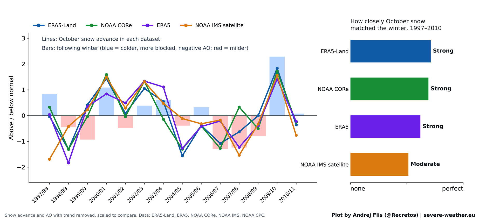
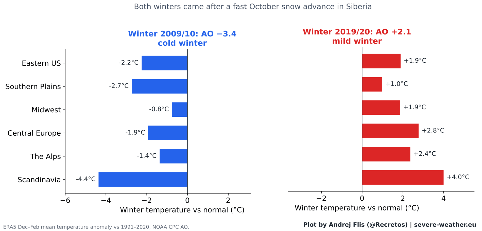
- The 2011 Landmark Study: Published by Cohen and Jones, the foundational research utilized daily satellite snow maps available at the time—spanning a 14-winter window from 1997 to 2010. During this specific epoch, the correlation was remarkably robust, driven in large part by standout extreme winters like 2009/2010, which featured rapid Siberian snow build-up followed by a historic negative AO phase and crippling blizzards across the eastern United States.
- The Post-2011 Divergence: As subsequent winters unfolded, the predictive power of the metric began to wane. For instance, Winter 2019/2020 followed an exceptionally rapid October snow advance yet ultimately manifested as one of the strongest positive AO phases and warmest winters on record across Europe and large parts of North America.
- October 2026 and Winter 2026/2027 Outlook: Current ECMWF forecasts indicate a slow start to October snow cover during the first week, followed by a projected aggressive surge over the subsequent fortnight. Evaluated against historical analogues, this potential rapid snow advance aligns with years that yielded mixed, highly variable winter outcomes—proving that surface snow alone is no longer a reliable standalone predictor.
Supporting Data: What 47 Years of Reanalysis Reveals
To ensure scientific rigor, researchers cross-referenced 47 winters of data (1979–2025) across four independent snow datasets: ERA5, ERA5-Land, NOAA IMS 24 km satellite observations, and NOAA CORe reanalysis.
Performance Scorecard
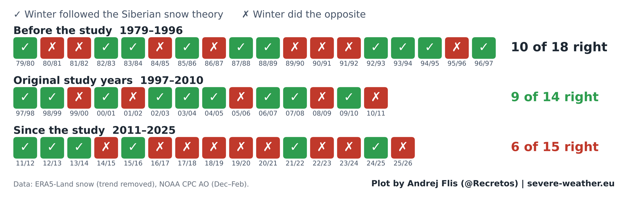
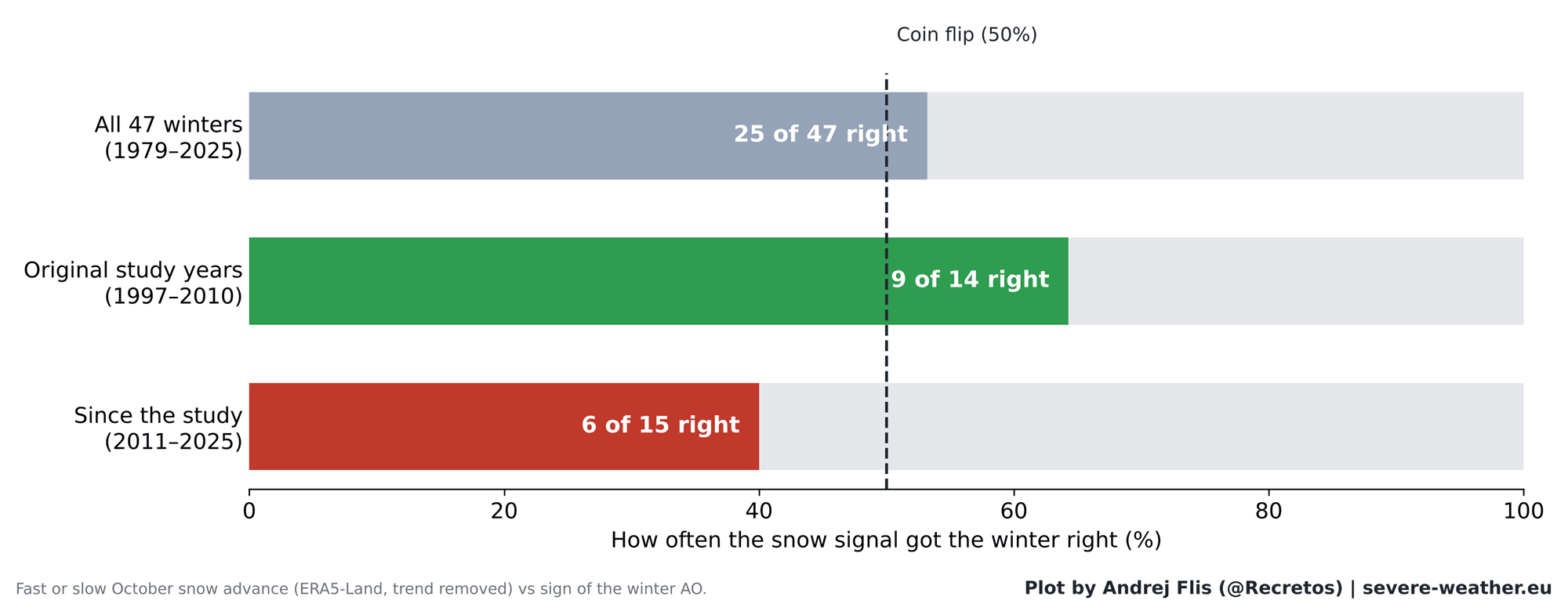
- The Original Study Period (1997–2010): The signal performed admirably, accurately forecasting the general winter AO tendency in 9 out of 14 years.
- The Post-Study Era (2011–Present): Across the 15 winters following the publication of the study, the snow-advance index was correct in only 6 out of 15 years—a success rate notably worse than random chance.
- Overall 47-Year Track Record: Across the entire multi-decadal dataset, the indicator was right 25 times and wrong 22 times, confirming that its long-term predictive skill is equivalent to a 50/50 coin flip.
+---------------------------+----------------+----------------+
| Evaluation Period         | Correct Calls  | Incorrect Calls|
+---------------------------+----------------+----------------+
| Original Study (97-10)    | 9              | 5              |
| Post-Study Era (11-Pres)  | 6              | 9              |
| Full 47-Year Dataset      | 25             | 22             |
+---------------------------+----------------+----------------+
Furthermore, regional impact checks across 11 distinct zones in North America and Europe confirmed that localized correlations (such as winter cold in the eastern U.S. or precipitation patterns in Europe) observed prior to 2011 have completely broken down in contemporary data.
Official Responses and Expert Insights: The Shift to Stratospheric and Oceanic Drivers
Atmospheric scientists emphasize that while the surface snow-to-stratosphere pathway has grown unreliable, the broader mechanics of stratospheric-tropospheric coupling remain vital. The upward flow of planetary wave energy during November and December continues to serve as an authentic leading indicator for a disrupted Polar Vortex in mid-winter. When significant energy flux occurs in late autumn, the odds of a destabilized vortex roughly double.
However, modern seasonal forecasting places far greater weight on macro-scale oceanic drivers—specifically, the ongoing Super El Niño event in the Pacific Basin.
The Dominant Role of the Super El Niño
According to recent meteorological analyses and seasonal ECMWF model outputs, the Super El Niño is exerting a profound influence on the Northern Hemisphere jet stream, storm tracks, and stratospheric wind profiles for Winter 2026/2027:
- Stratospheric Deceleration: Model simulations demonstrate that strong El Niño events induce significant stratospheric deceleration of the Polar Vortex zonal winds by mid-to-late winter.
- Potential for Sudden Stratospheric Warming (SSW): ECMWF zonal wind forecasts at the 10 hPa level indicate a dramatic drop in vortex wind speeds below normal climatology by late December and January, pointing toward a heightened risk of a mid-winter vortex split or collapse.
- Temperature Anomalies: Historically, the aftermath of major vortex disruptions paired with a strong El Niño pattern favors amplified storm tracks and cooler temperature anomalies across the southern, central, and eastern United States, while northern Europe and parts of Canada experience more variable or milder regimes.
Implications for Winter 2026/2027
As weather forecasters and the public look ahead to the unfolding winter season, the myth of the Siberian snow advance must be put into proper perspective.
- Abandoning Single-Metric Reliance: A fast October snow advance in Siberia does not guarantee a brutal winter, nor does a slow start preclude one. The historic correlation has dissolved due to shifting baseline conditions, potentially influenced by rapid Arctic sea ice reduction, altered ocean temperatures, and changing atmospheric teleconnections.
- Data Integrity Note: Researchers parsing modern reanalysis datasets must remain vigilant; comparative checks between ERA5 and independent NOAA CORe data revealed an artificial ~40% drop in ERA5 Eurasian October snow cover around 2004 due to observational data assimilation updates. Fortunately, cross-dataset validation confirms this anomaly did not impact core climatological conclusions.
- Focus on Verified Drivers: For Winter 2026/2027, forecasters will monitor late-autumn stratospheric wave-energy fluxes and the evolving Super El Niño anomaly. These robust dynamics—rather than surface snow cover alone—will dictate whether the Polar Vortex maintains its integrity or undergoes a dramatic, cold-inducing collapse in the months ahead.
