

Every autumn, as the first chills of the approaching cold season settle over the Northern Hemisphere, a familiar narrative reemerges across weather forums, meteorological blogs, and social media channels. The central question is always the same: Is snow spreading rapidly across Siberia?
For over a decade, a pervasive belief has held that a swift October snow advance across the vast Eurasian landmass acts as an infallible, early-warning indicator for a harsh, brutal winter across the United States, Canada, and Europe. Originating from a celebrated 2011 scientific study, this "Siberian Snow Theory" has been regurgitated year after year as a cornerstone of long-range forecasting.
However, with a fast snow surge forecast once again for October, a comprehensive new data analysis of 47 winters spanning from 1979 to 2025—utilizing four distinct snow datasets, including the original satellite metrics—turns conventional wisdom on its head. The results are startling: the once-prominent snow signal has steadily eroded into little more than a statistical coin flip, forcing meteorologists to look elsewhere, particularly toward a historic Super El Niño, to understand what Winter 2026/2027 has in store.
Main Facts: The Rise, Fall, and Mechanics of the Snow Theory
The Core Premise
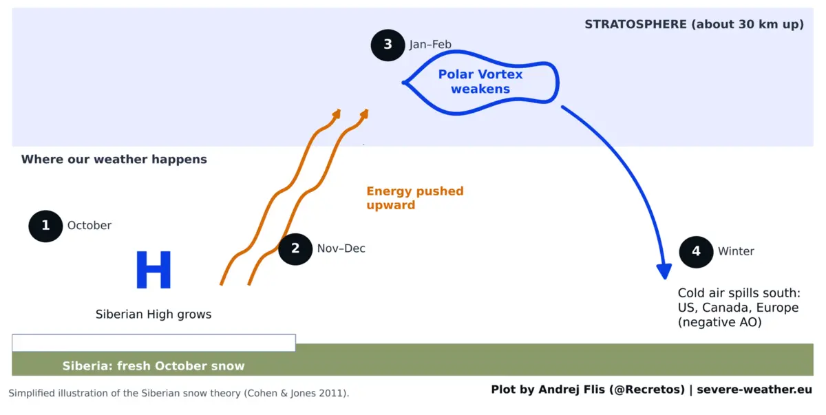
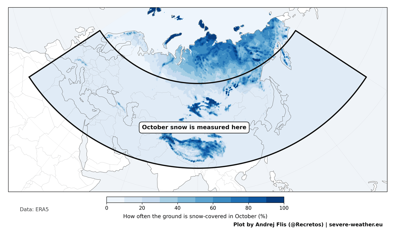
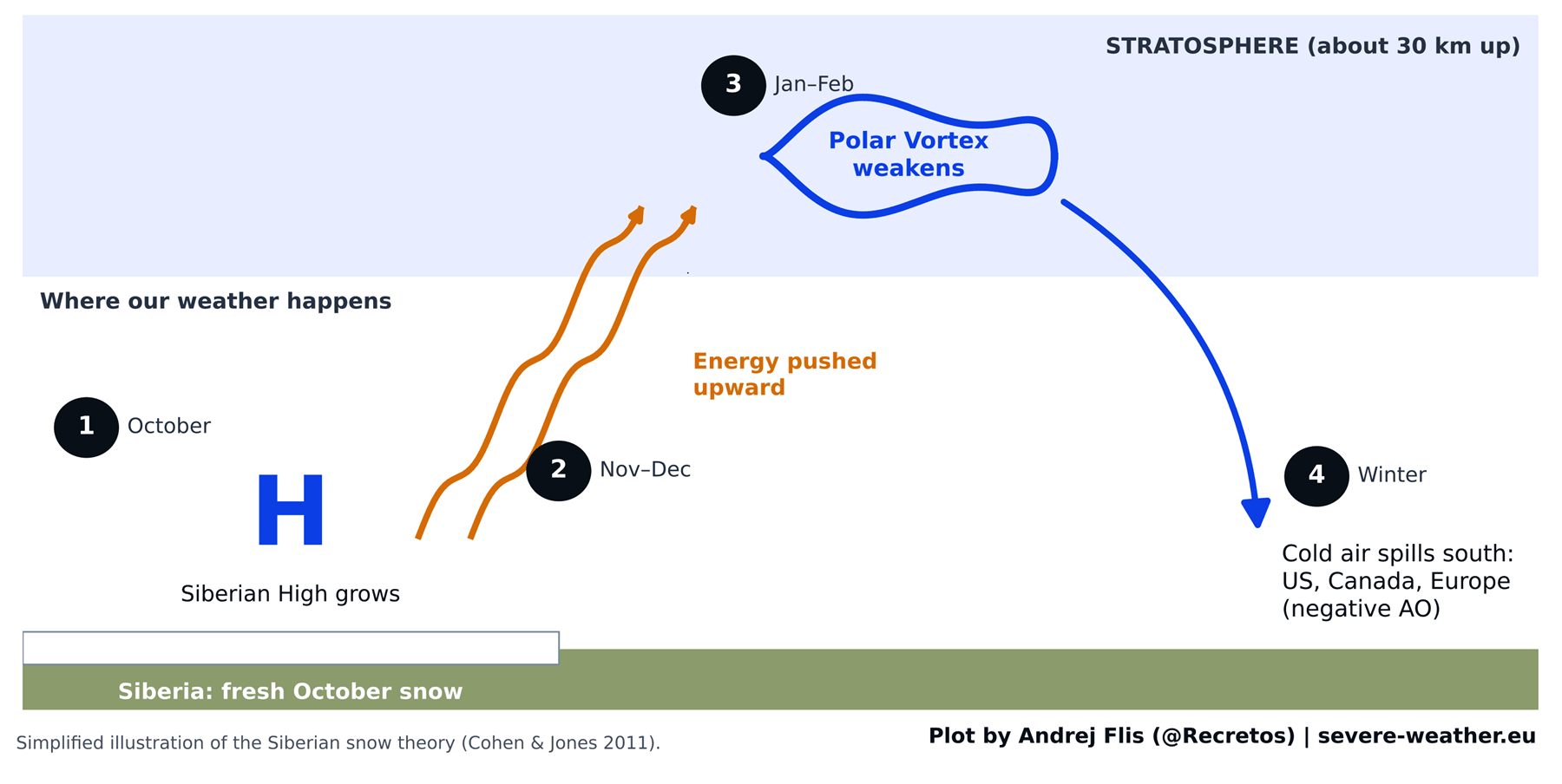
The foundation of the Eurasian snow theory is deceptively elegant and rooted in well-established thermodynamic physics. Published in 2011 by researchers Judah Cohen and Justin Jones, the study demonstrated that a rapid expansion of October snow cover across Eurasia—stretching from Western Europe to the Pacific coast, with heavy accumulations in southern Siberia, Mongolia, and the Tibetan Plateau—cools the underlying ground aggressively.
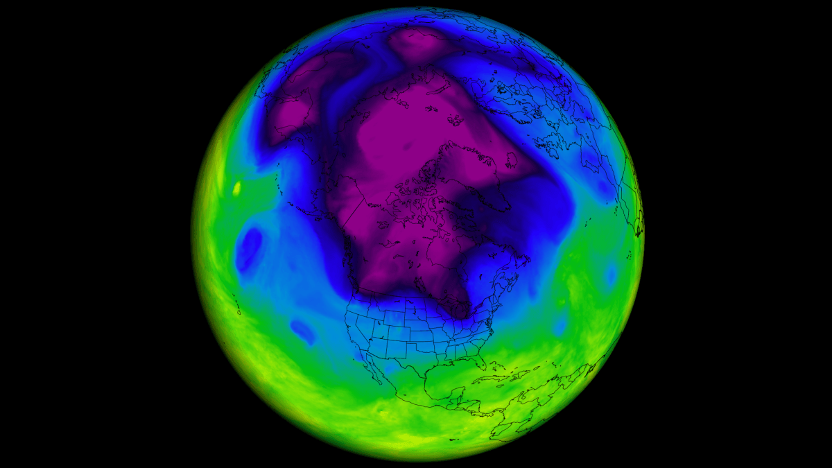
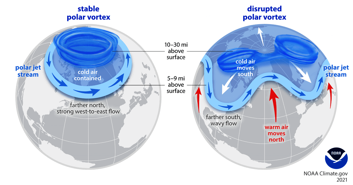
This surface cooling strengthens the Siberian High, a massive semi-permanent pool of cold, dense air over northern Asia. According to the theory, this high-pressure center pumps excess planetary energy upward into the stratosphere, roughly 18.5 miles (30 km) above the Earth. This upward wave activity disrupts the Polar Vortex—the colossal ring of stratospheric winds that normally bottles up bitter Arctic air over the North Pole.
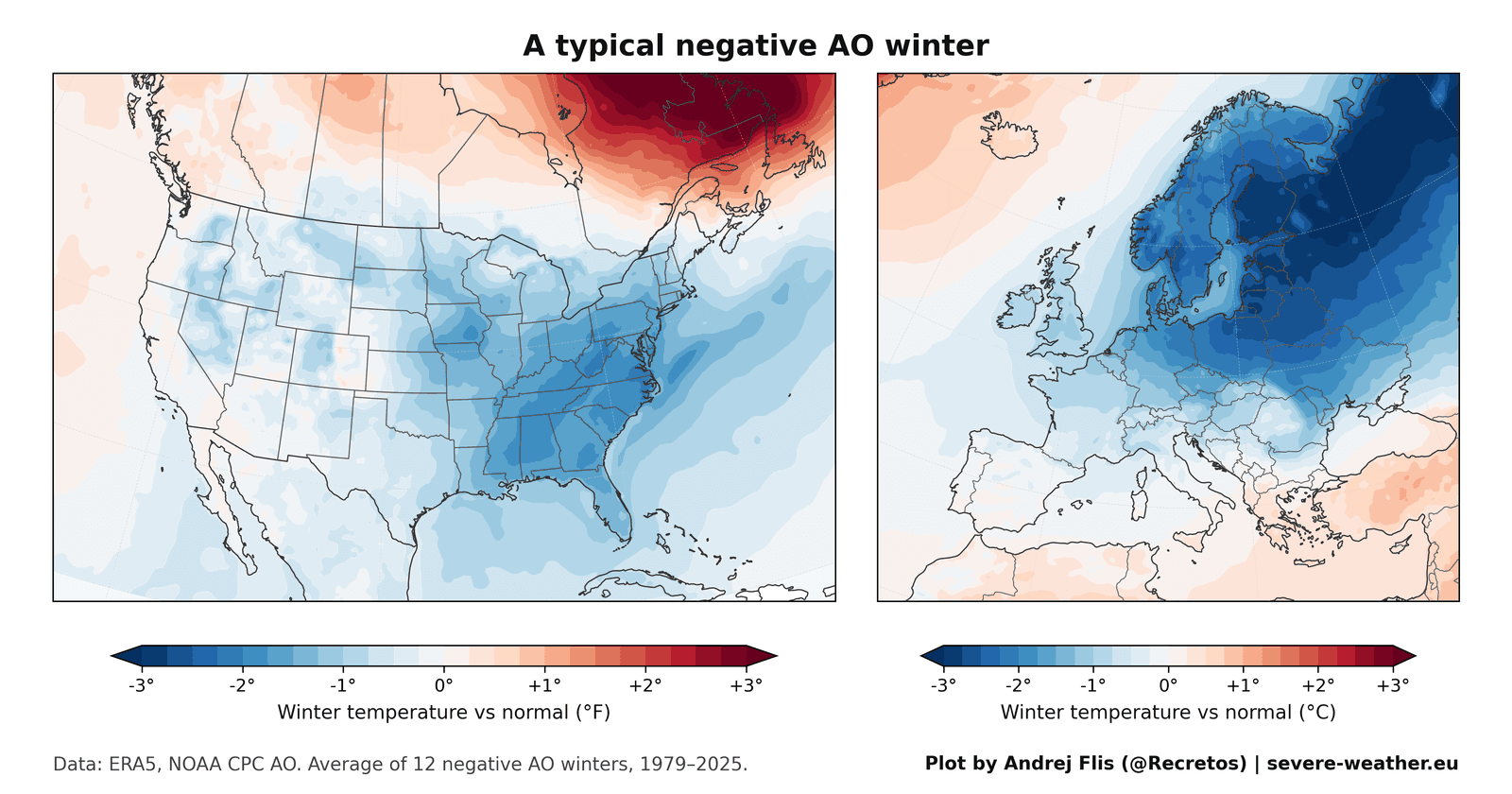
When the Polar Vortex becomes distorted, stretched, or collapses entirely, lobes of extreme cold break away, spilling southward into mid-latitude population centers. Meteorologists track this via the Arctic Oscillation (AO). A negative AO phase facilitates these southern incursions, favoring severe winters in the eastern United States and northern Europe, while leaving eastern Canada unusually mild.
The Modern Reality Check
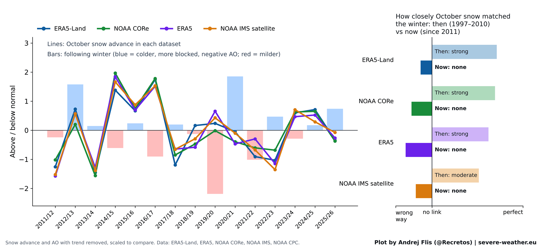
While the physical chain reaction from the stratosphere downward remains sound, the initial link connecting October Siberian snow to that chain has broken down.
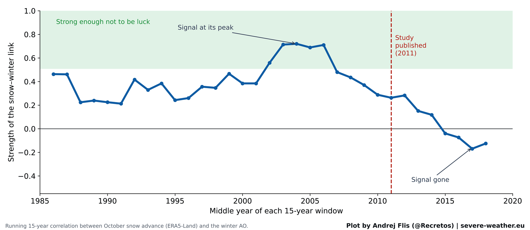
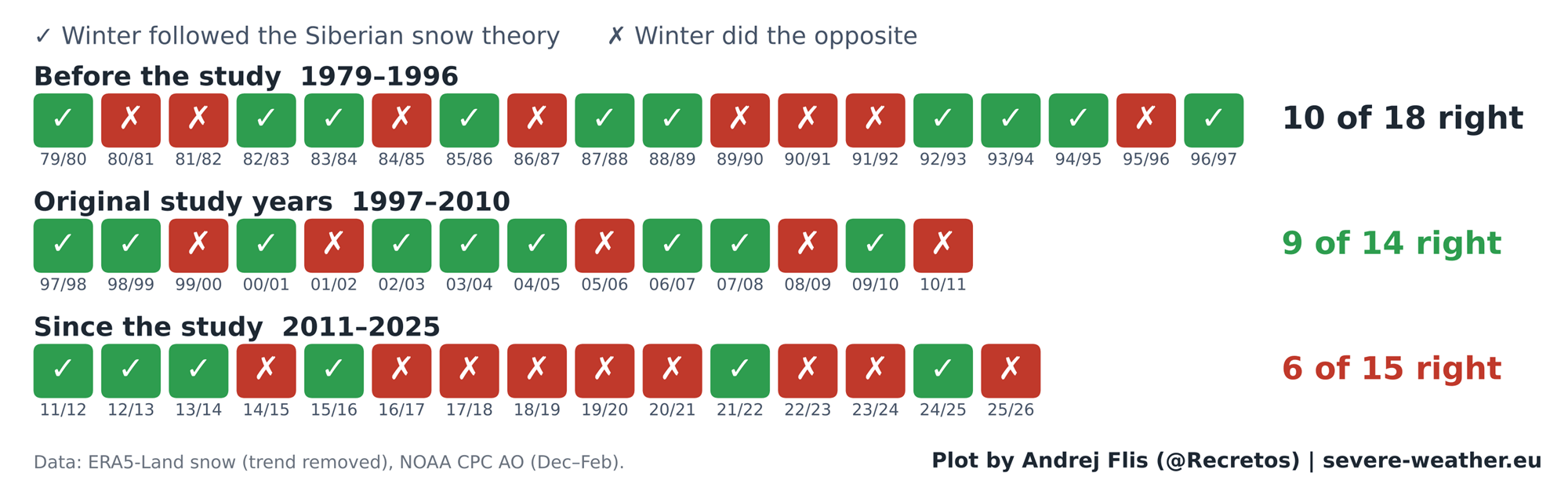
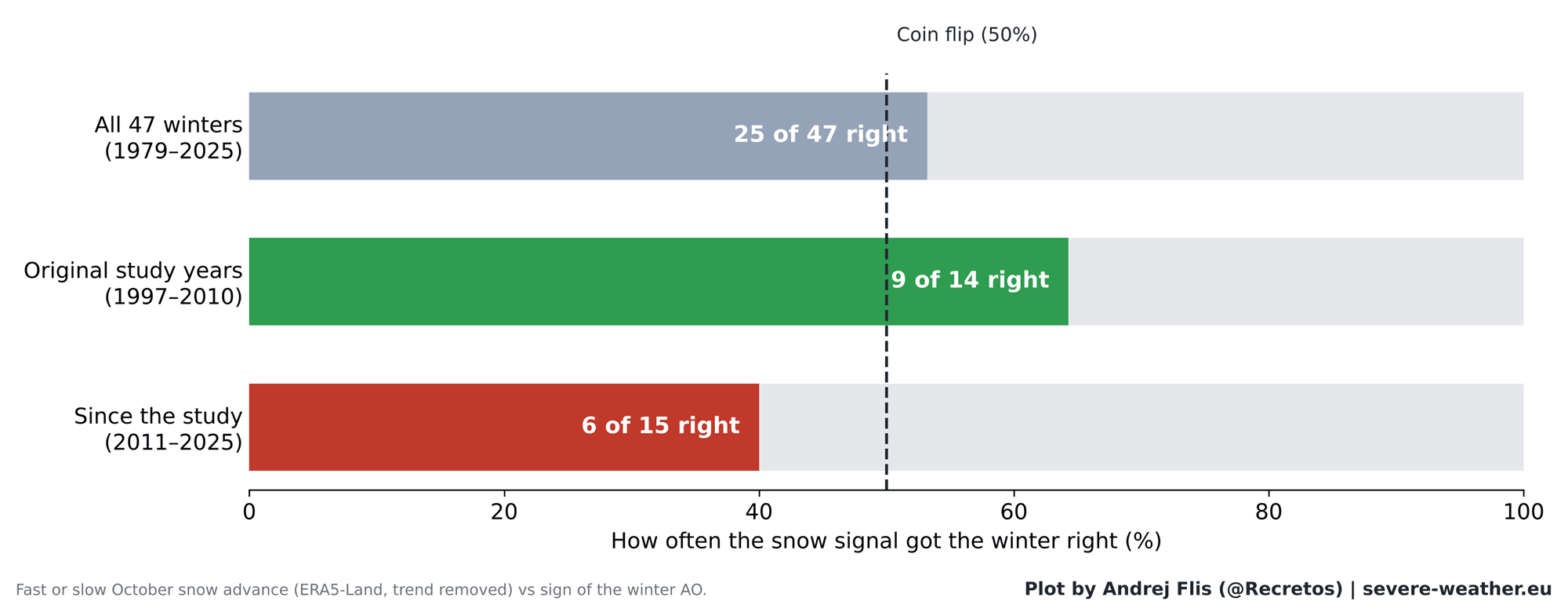
When researchers tested 47 years of historical data (1979–2025) across multiple datasets—incorporating 15 new winters that occurred after the original study was published—the predictive skill evaporated. Over the full 47-year timeline, the snow signal proved correct 25 times and wrong 22 times—precisely a 53% accuracy rate, statistically indistinguishable from a coin toss. Even more damningly, in the 15 winters since the 2011 study’s publication, the indicator has been right on only 6 occasions, performing worse than random chance.
Chronology: From Groundbreaking Discovery to Modern Breakdown
1997–2010: The Golden Era of the Theory
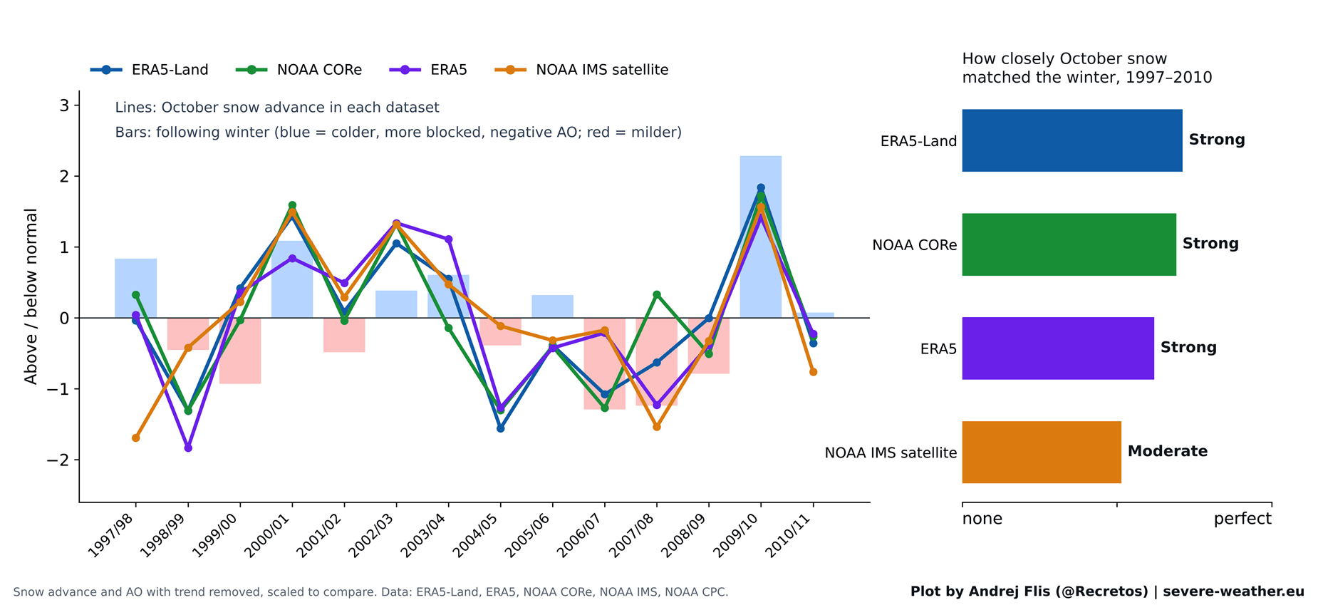
The theory’s initial success was not a fluke; it was built on a robust, albeit short-lived, period of atmospheric behavior. During the baseline years of the original study (roughly 1997 to 2010), the correlation between October snow advance and subsequent winter AO behavior was remarkably strong.
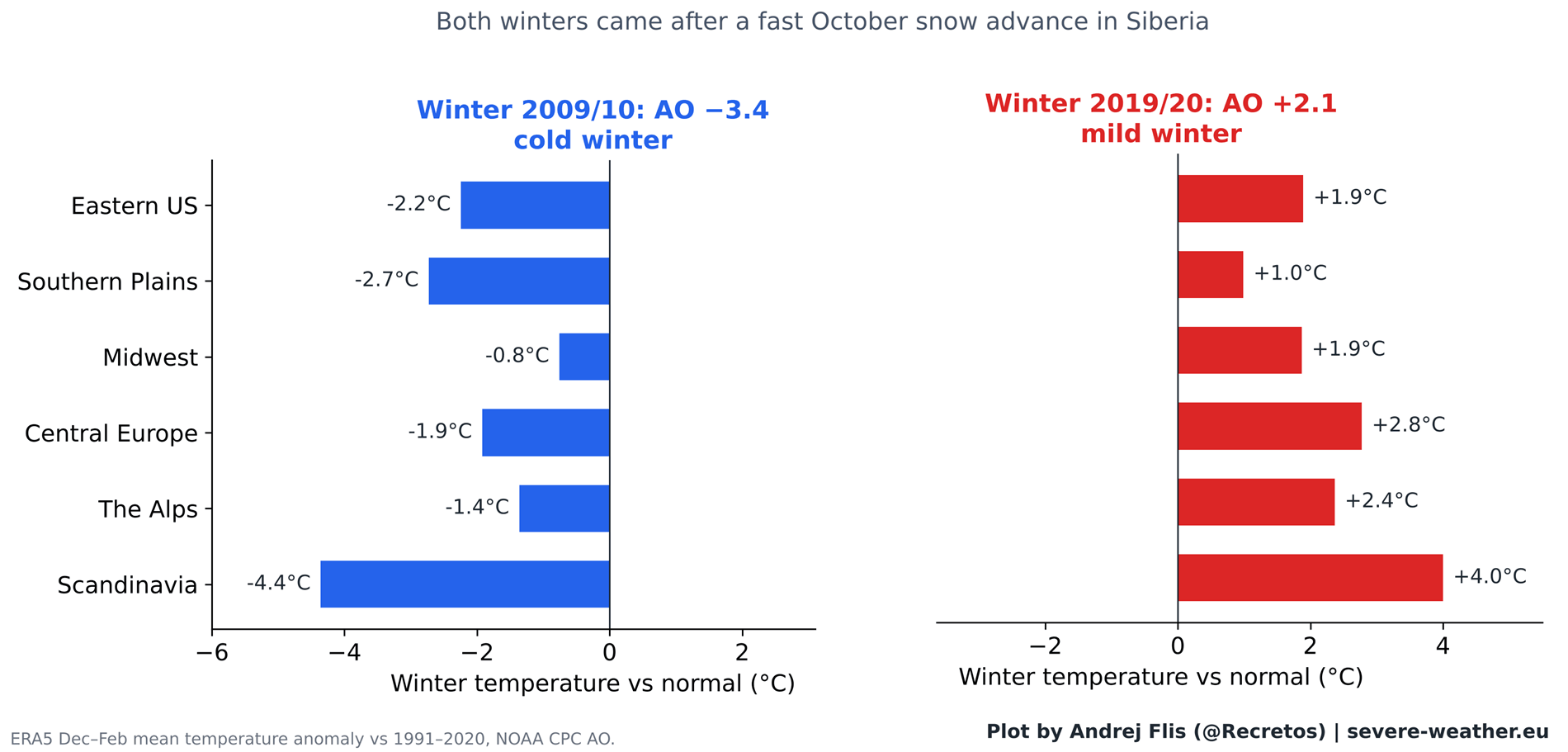
The crown jewel of this era was Winter 2009/2010. Following one of the fastest October snow advances on record, that winter delivered the most negative AO phase recorded up to that time. It triggered severe cold across Europe and the historic, paralyzing February 2010 snowstorms across the Eastern United States. This single, high-profile event cemented the theory in the public imagination, making the connection appear infallible.
2011–Present: The Fading Signal
Immediately following the publication of the 2011 paper, the relationship began to decouple. For instance, Winter 2019/2020 also followed a rapid October snow advance. Yet, it yielded an entirely opposite outcome: one of the strongest positive AO winters on record, accompanied by exceptionally mild conditions and a near-absence of snow across both Europe and large parts of the United States.
Time-series analyses tracking 15-year sliding windows show that the predictive strength of the October snow index peaked sharply in the mid-2000s and has experienced a steady, secular decline ever since, dipping into negative correlation territory in recent years.
Supporting Data: Dissecting the Four-Dataset Analysis
To ensure absolute scientific rigor, independent researchers cross-verified observations using four distinct, high-resolution snow datasets:
- NOAA IMS (Interactive Multisensor Snow and Ice Mapping System) at 24 km resolution.
- NOAA CORe reanalysis tools.
- ERA5 (Copernicus C3S/ECMWF reanalysis).
- ERA5-Land datasets.
The Dataset Quirk: The 2004 ERA5 Drop
During the compilation of these historical datasets, an intriguing anomaly emerged. In the standard ERA5 reanalysis, Eurasian October snow cover drops abruptly by approximately 40% in the year 2004. Cross-comparison with NOAA CORe and satellite records proved this was a synthetic artifact tied to when ECMWF began ingesting specific satellite snow mapping instruments, primarily affecting Siberian lowlands between 50°N and 70°N. Fortunately, because ERA5-Land and independent NOAA metrics corroborated the primary trends, the overarching conclusions regarding the theory’s breakdown remain entirely secure.
Regional Breakdown Across North America and Europe
When evaluating how October snow impacts localized backyard weather across 11 specific climate regions:
- The Past: During the 1997–2010 window, eastern U.S. winter temperatures and southwestern/northern European precipitation trends correlated cleanly with rapid Siberian snow.
- The Present: Out of 44 localized regional checks conducted for the post-2011 era, only one displayed a statistically significant signal (a weak, non-actionable long-term hint in Western Canada). All other regional links have completely dissolved.
Official Responses and Scientific Perspectives
The scientific community is increasingly viewing long-range forecasting through a holistic lens rather than relying on single-parameter indicators.
Recent literature highlights that while the stratospheric Polar Vortex remains a critical engine for winter weather, the triggers initiating its disruption are multifaceted. A landmark September 2026 study by Songmiao Fan and Judah Cohen suggests that Eurasian snowpacks may still promote "stretched" Polar Vortex configurations favorable to long cold spells in the eastern U.S., but acknowledges that surface snow is competing with an increasingly noisy climate background.
Rapid Arctic sea ice loss, unprecedented oceanic warming, shifting baseline jet streams, and teleconnections linked to tropical Pacific dynamics now heavily outweigh the isolated influence of Siberian ground cover.
Implications: What to Expect for Winter 2026/2027
As meteorologists turn their attention to the unfolding cold season, the forecast reveals a nuanced picture for North America and Europe.
The October 2026 Snow Surge
Current ECMWF ensemble forecasts indicate that after a sluggish, below-normal start to October 2026, a massive surge of high-latitude Siberian snow is slated to accumulate rapidly before the month closes. This will likely place October 2026 in the top 15% for early-season snow advance rates over the last three decades.
Historically, the six analog years featuring the most similar October snow trajectories yielded mixed results: three negative AO winters, one neutral, and two positive. Clearly, the snow advance alone cannot dictate the upcoming winter’s character.
The True Heavyweight: The Super El Niño
Instead of looking eastward toward Siberia, long-range forecasters are training their eyes squarely on the tropical Pacific. A historic Super El Niño is currently active, dominating global sea surface temperature anomalies.
Numerical models, including the latest ECMWF seasonal outlooks, demonstrate that this intense El Niño is poised to significantly decelerate stratospheric zonal winds by late December and January. The metrics point toward an elevated risk of a Sudden Stratospheric Warming (SSW) event—a dramatic mid-winter collapse of the Polar Vortex.
Regional Outlooks for Mid-to-Late Winter 2027
- United States: Driven by the amplified Pacific jet stream and the downstream impacts of a destabilized Polar Vortex, the central, southern, and eastern United States face an enhanced probability of cooler-than-average temperature anomalies and active storm tracks. Persistently cloudy, wet regimes will keep regional temperatures depressed, echoing the classic "Polar Express" setups seen in prior disruption winters.
- Europe: Current medium-to-long-range ensemble projections for Europe lean toward a predominantly mild westerly or southwesterly flow across central and southern sectors. The primary cold anomalies remain stubbornly locked over northern Europe and Scandinavia, suggesting that—barring a sudden atmospheric shift—the most intense winter impacts are currently favored to target North America.
Summary
The era of treating October Siberian snow as a winter crystal ball has officially drawn to a close. While the atmosphere remains an interconnected web where surface conditions and stratospheric dynamics converse, the Siberian snow signal has faded into statistical noise. For Winter 2026/2027, forecasters will leave the snow-cover metrics behind, focusing instead on the titanic atmospheric signals of the Super El Niño and the impending mid-winter pulse of the Polar Vortex.
