

As the autumn leaves fall and temperatures begin to dip across the Northern Hemisphere, a familiar ritual plays out across weather forums, meteorological blogs, and social media channels. Enthusiasts and forecasters alike fixate on a single geographic expanse: Siberia. The burning question every October is invariably the same: Is snow spreading fast across Siberia?
For more than a decade, a widespread belief has persisted that a rapid October snow advance across Eurasia serves as a reliable crystal ball—an early warning sign of a severe, snowy winter destined for the United States, Canada, and Europe. Rooted in a landmark 2011 scientific study, this theory has been parroted winter after winter. However, with a fast snow surge forecasted for October, meteorologists have taken a fresh, hard look at the data to determine whether this famous winter forecasting signal still holds water in the modern era.
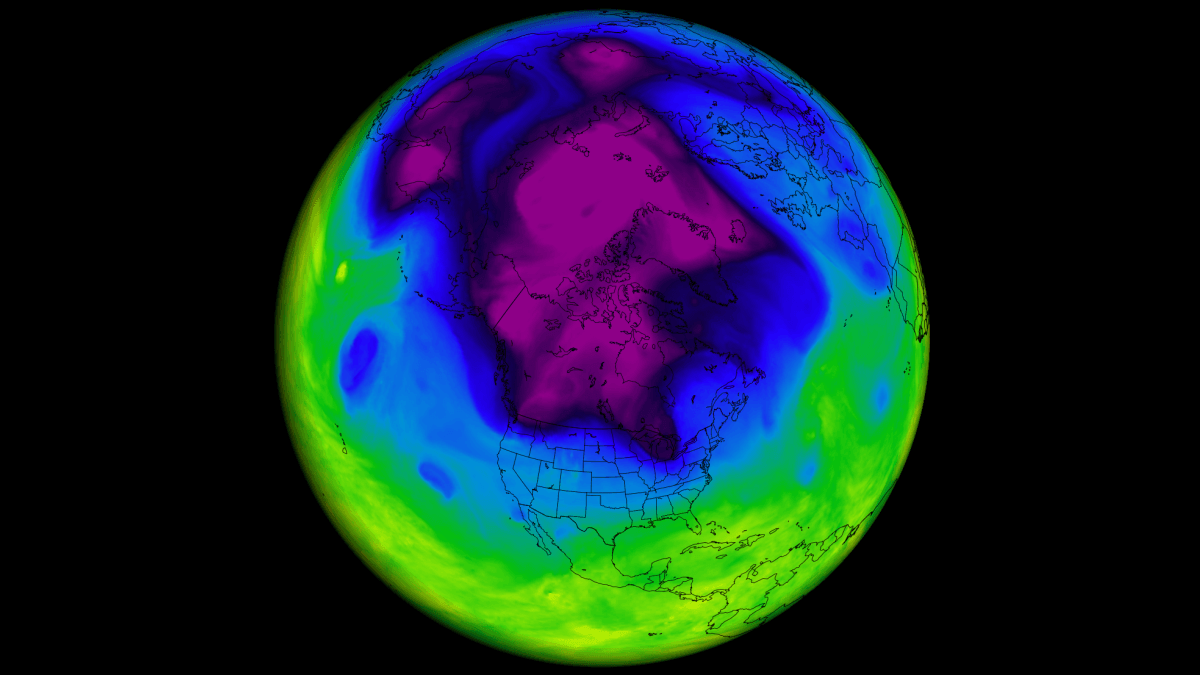
By analyzing 47 winters of data spanning from 1979 to 2025 across four distinct snow datasets—including the exact satellite observations utilized in the original research—researchers have uncovered surprising results. These findings fundamentally challenge how we interpret October snowfall, compelling a re-evaluation of how stratospheric dynamics and oceanic anomalies truly drive our winter weather.
The Expanding Snow Theory: How a Snowy October Became a Winter Signal
The 2011 Breakthrough
In 2011, atmospheric scientists Judah Cohen and Justin Jones published a study detailing a remarkable meteorological signal. They investigated the rate at which snow cover expanded across Eurasia during October and hypothesized about its downstream impacts on the upcoming winter season. Their premise was straightforward yet profound: the faster the Eurasian snowpack advanced, the higher the probability that the subsequent winter would feature severe outbreaks of bitter Arctic air spilling into the mid-latitudes of North America and Europe.
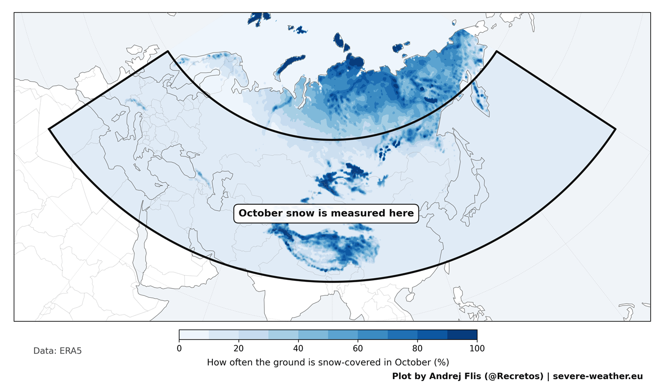
The geographic footprint of this theory is massive, stretching from Western Europe all the way to the Pacific coast of Russia. The bulk of this critical October snow accumulation typically occurs across southern Siberia, Mongolia, and the elevated terrains of Central Asia and the Tibetan Plateau.
The Physical Mechanism: Surface to Stratosphere
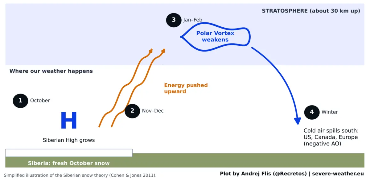
On paper, the physical mechanics driving this theory are exceptionally sound. Fresh, expansive snow cover rapidly cools the overlying ground, dramatically strengthening the Siberian High—a sprawling, semi-permanent area of cold, dense high pressure that forms over northern Asia during the cold months.
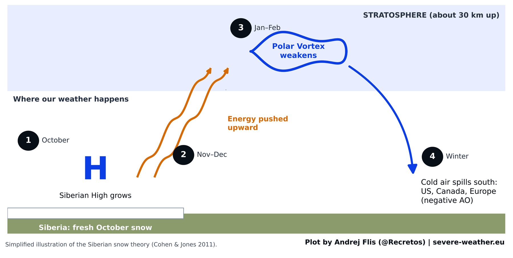
This robust high-pressure system acts as an atmospheric piston, pumping excess planetary wave energy vertically into the stratosphere, roughly 18.5 miles (30 kilometers) above the Earth’s surface. Once this energy penetrates the stratosphere, it disrupts the Polar Vortex—a massive, counter-clockwise ring of strong winds that normally acts as an atmospheric containment vessel, trapping the core of the planet’s coldest air tightly over the North Pole.
When this energy assault weakens or destabilizes the Polar Vortex, the vortex stretches, wobbles, or splits entirely. Lobes of frigid Arctic air are then liberated, breaking away from the polar cap to surge southward into the United States, Canada, and Europe.
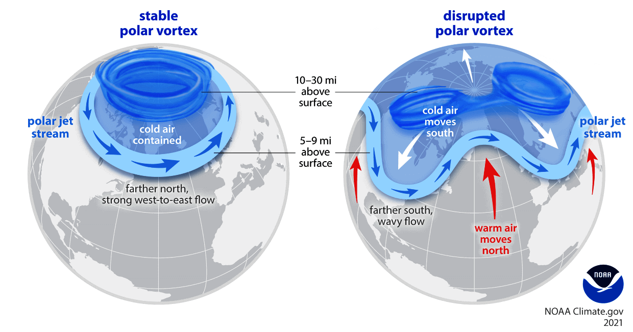
Meteorologists track the resulting atmospheric behavior using the Arctic Oscillation (AO) index. A positive AO locks the cold air firmly inside the Arctic circle, fostering milder winters. Conversely, a negative AO index lowers the atmospheric guardrails, allowing massive cold air outbreaks to flood the mid-latitudes. According to the original Siberian snow theory, a rapid October snow surge should reliably trigger a negative AO winter, bringing deep freezes to the eastern half of the United States and northern Europe.
Putting the October Snow Theory to the Test
Expanding the Historical Dataset
While the 2011 study was heralded as a breakthrough, it possessed a notable limitation: due to the availability of daily satellite snow mapping at the time, Cohen and Jones based their findings on a relatively brief 14-year baseline spanning from 1997 to 2010.
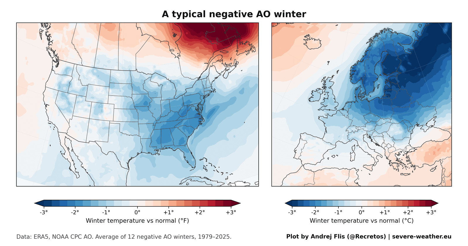
To conduct a definitive stress test on the theory, modern researchers expanded the scope to encompass 47 winters of data. Crucially, this dataset included 15 new winters that had occurred since the original paper was published—representing the ultimate test for any predictive model: how it performs on unseen, out-of-sample years.
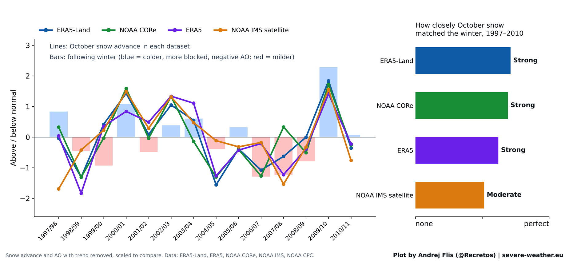
To eliminate data bias, scientists cross-verified their findings using four independent snow datasets, ranging from modern satellite observations to advanced atmospheric reanalysis models.
Chronology of a Fading Signal
Phase 1: The Golden Years (1997–2010)
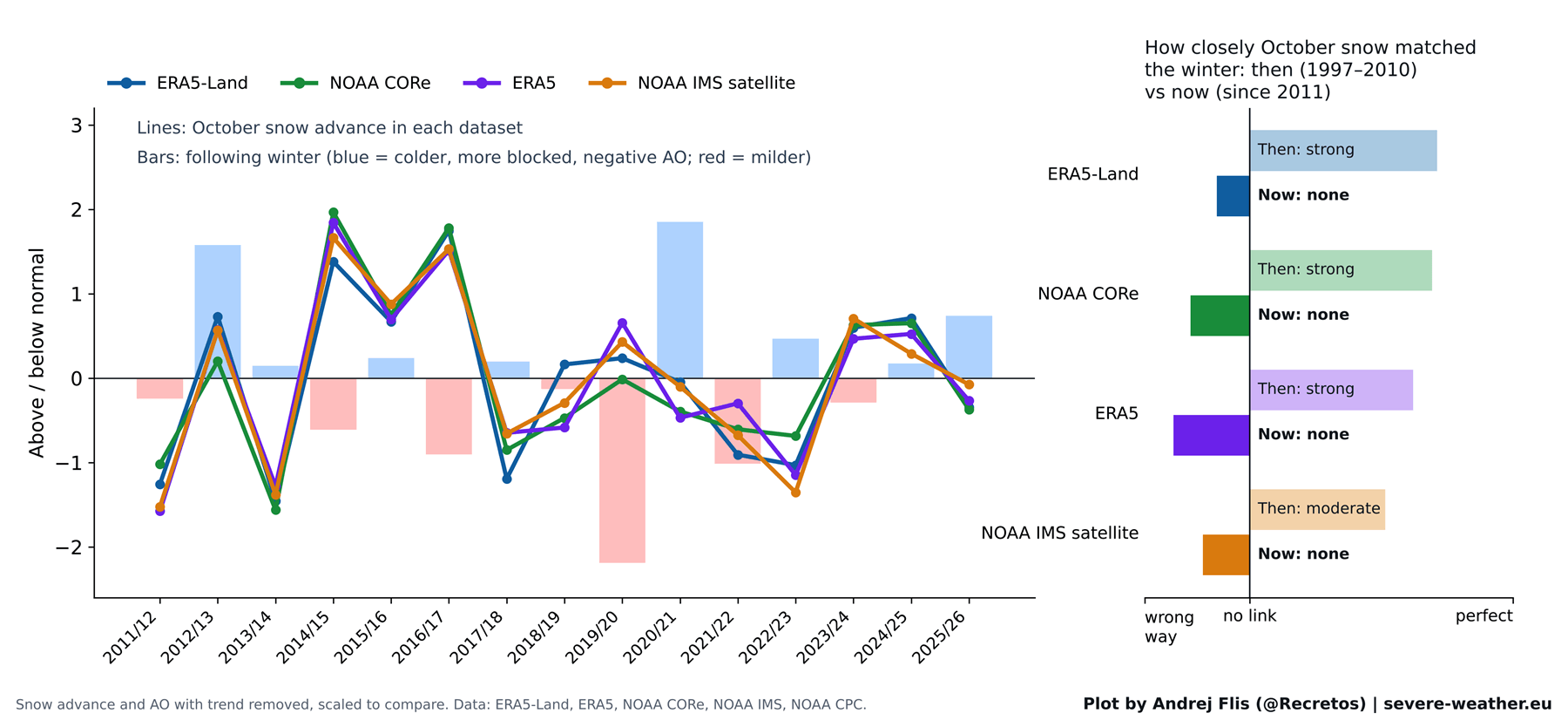
The initial phase of the modern data analysis yielded reassuring news for proponents of the original study. Across all four datasets, a clear, statistically significant link remained visible between October snow cover and the subsequent winter AO during the original 1997–2010 study period. The initial researchers had not erred; the correlation was genuinely present during that timeframe.
Phase 2: The Signal Fails After 2011
However, when researchers tracked the strength of the snow-winter connection over sliding 15-year windows, a startling trend emerged. The predictive signal peaked dramatically in the early-to-mid 2000s—precisely when the original research was being conducted.
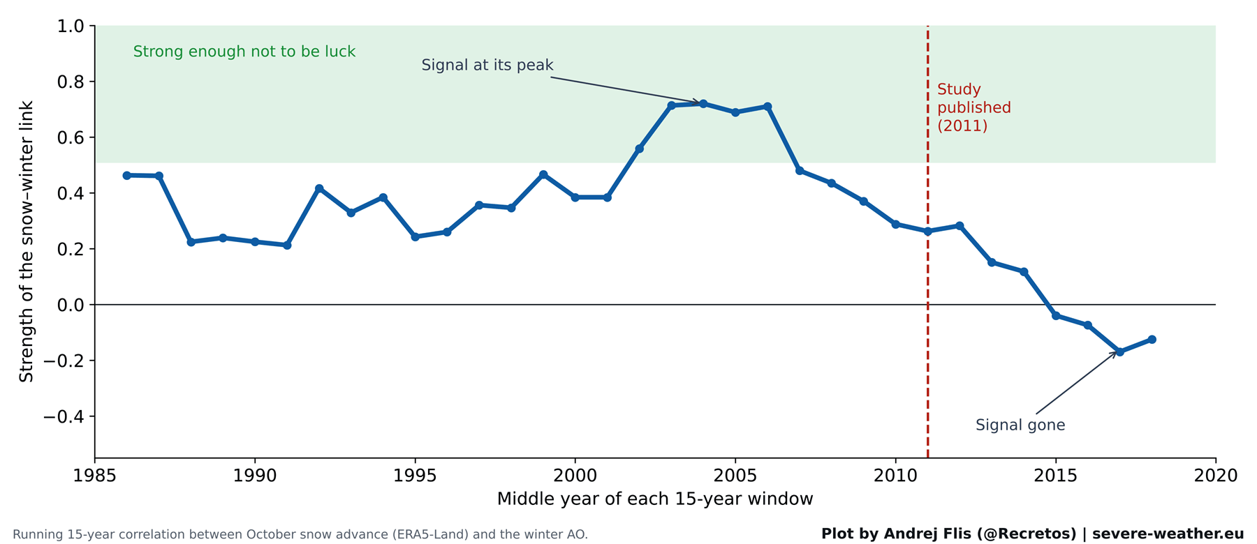
Following the publication of the 2011 study, the signal steadily degraded. When analyzing the 15 winters that followed, all four snow datasets agreed on a sobering conclusion: the winter forecast signal linking October Siberian snow to the Arctic Oscillation had entirely vanished.
Phase 3: The 47-Winter Scorecard
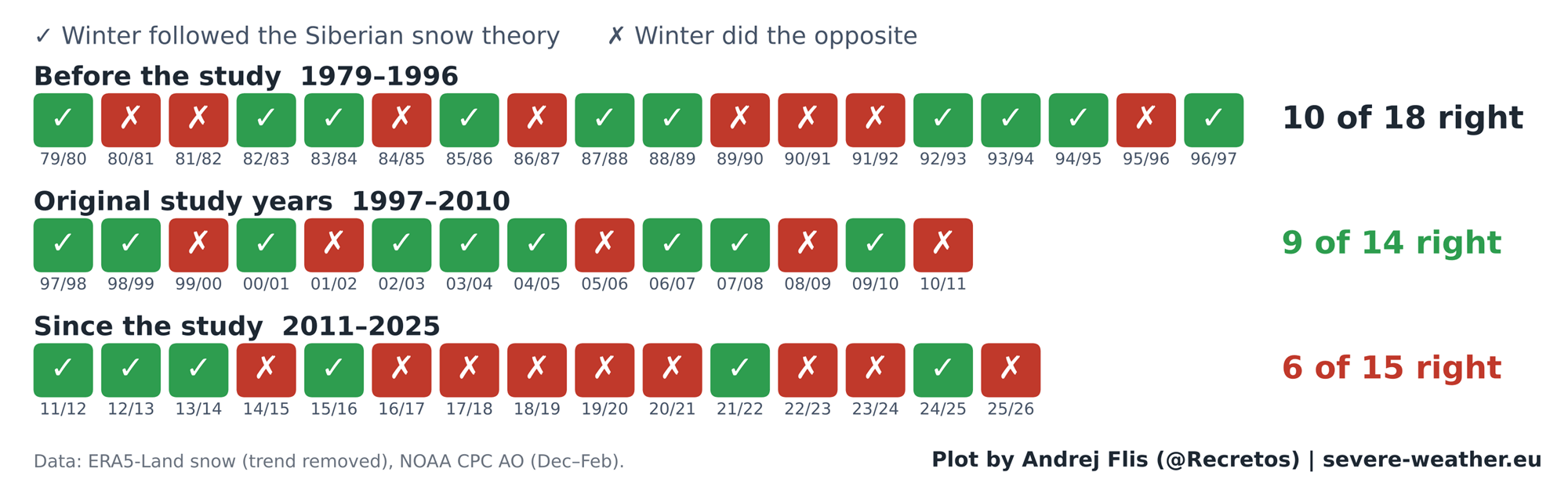
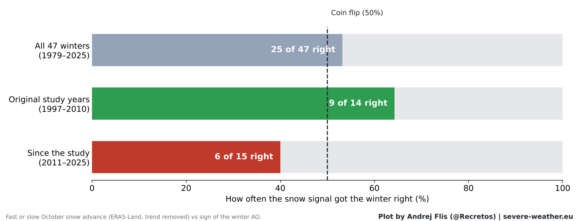
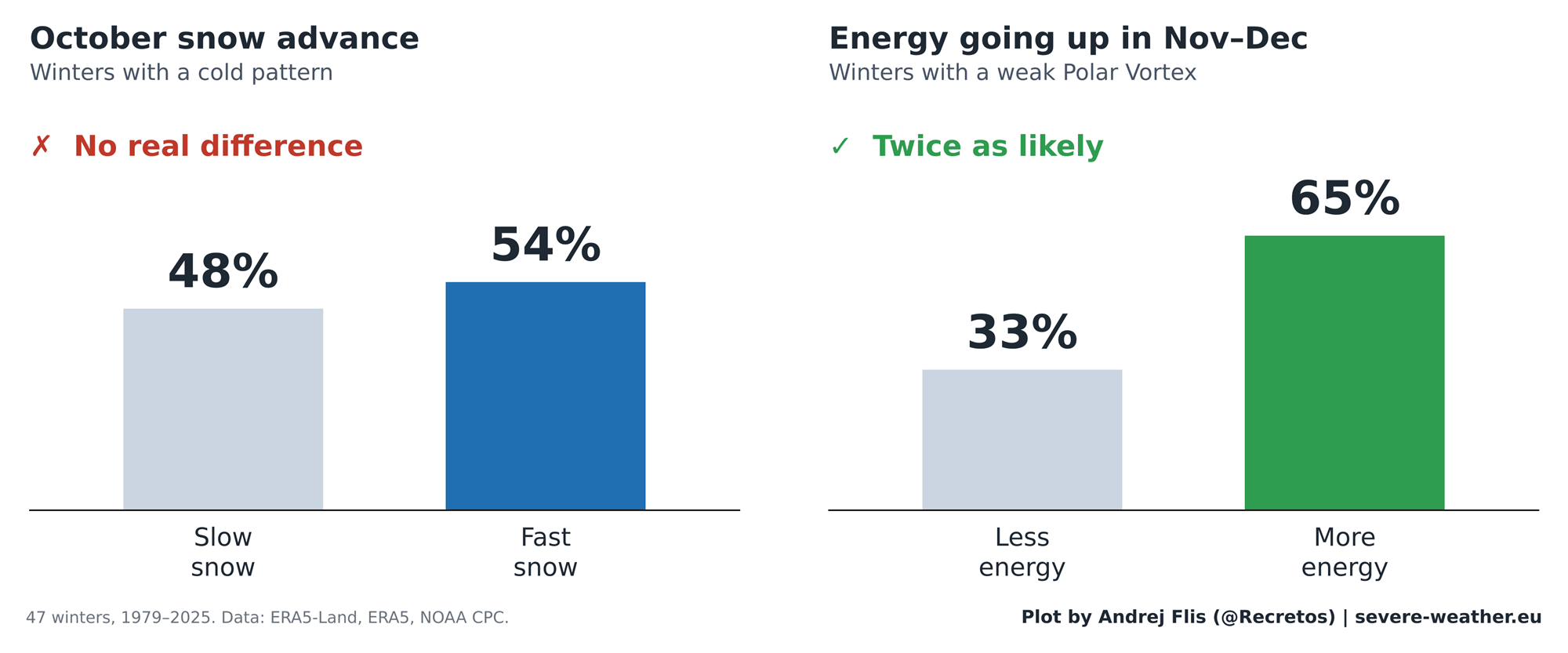
Looking at the complete 47-year timeline from 1979 to 2025, the October snow signal scored correctly 25 times and incorrectly 22 times. In statistical terms, this performance is virtually indistinguishable from a coin toss.
While it achieved an impressive 9-out-of-14 success rate during the original study years, it managed a dismal 6-out-of-15 success rate in the years following 2011—performing worse than random chance.
Supporting Data: Why Did the Theory Seem So Convincing?
Every robust scientific misconception requires a compelling anchor, and for the Siberian snow theory, that anchor was the historic winter of 2009/2010.
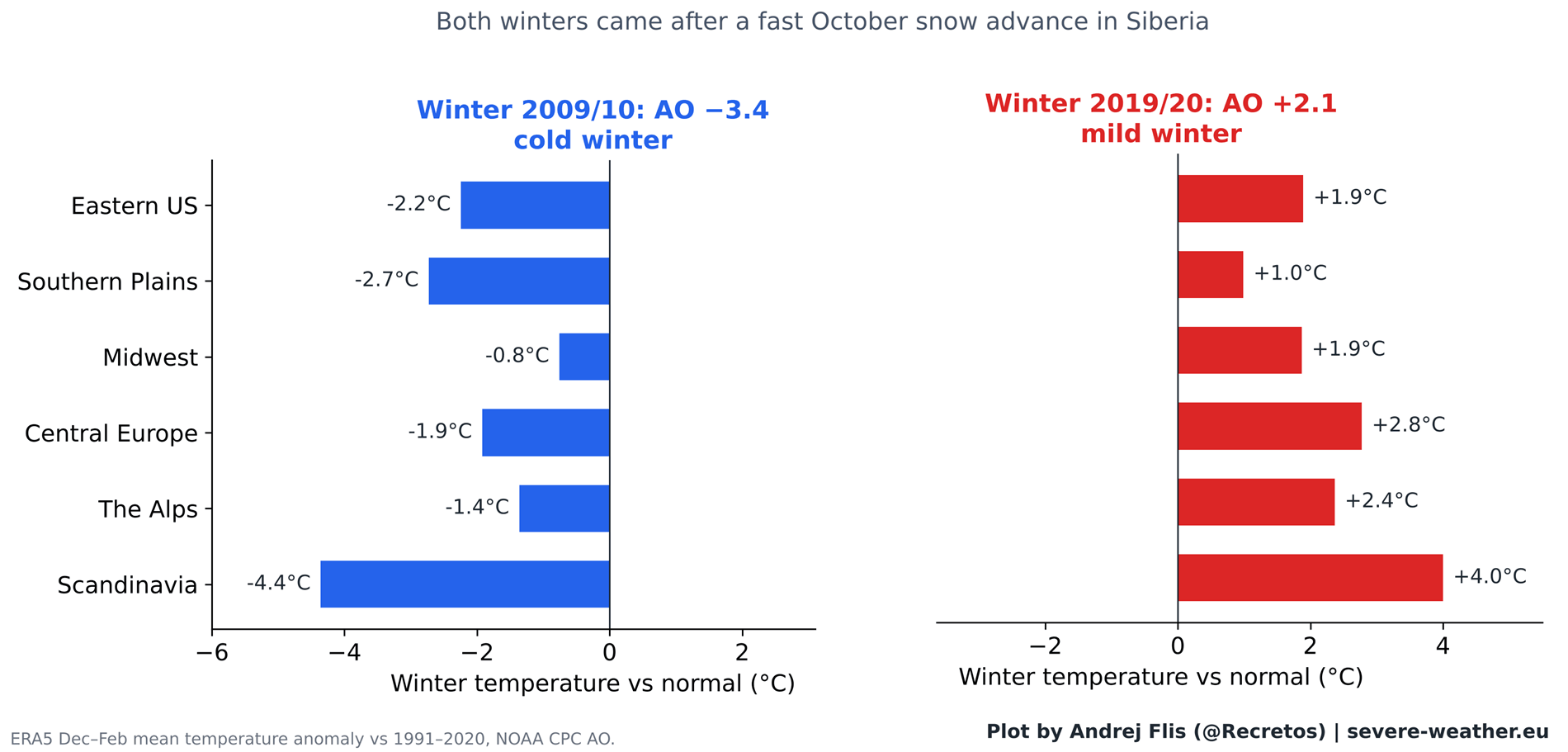
That winter was preceded by one of the fastest October snow advances on record. It subsequently yielded the most negative Arctic Oscillation on record at the time, generating punishing cold across Europe and triggering the historic, paralyzing February 2010 snowstorms across the Eastern United States. This textbook example provided a masterclass in atmospheric teleconnections, cementing the theory’s reputation.
Conversely, nature provided a stark contradiction in the winter of 2019/2020. Despite being preceded by an equally rapid October snow advance, the 2019/2020 winter featured one of the strongest positive AO phases ever recorded. It translated into an exceptionally mild, snow-starved winter across both Europe and large swaths of the United States.
Dissecting the Atmospheric Chain Reaction
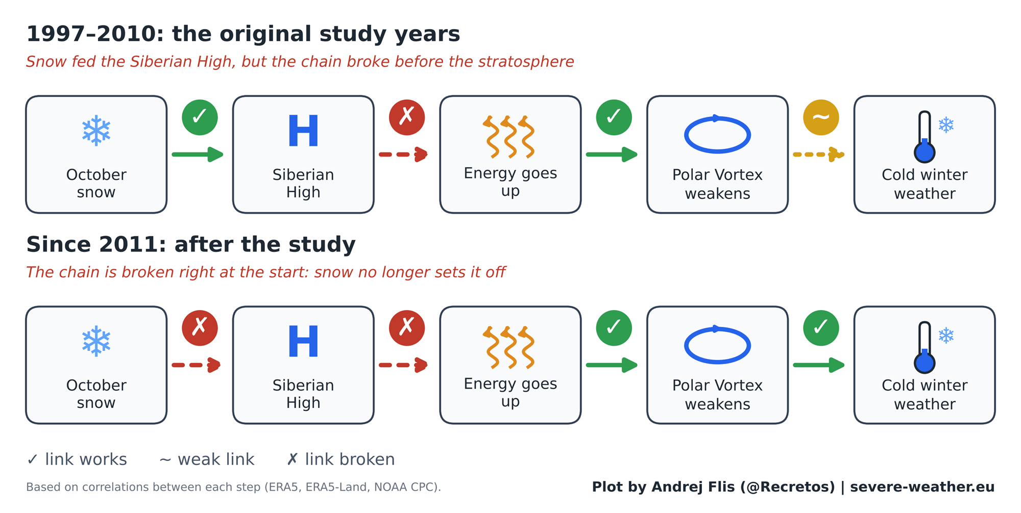
To uncover why the relationship broke down, researchers mapped out the multi-step chain reaction from October snow down to winter weather.
The latter half of the chain remains robust: when anomalous wave energy successfully propagates upward into the stratosphere during November and December, the Polar Vortex reliably weakens in January and February, frequently inducing severe winter weather.
However, the breakdown occurs at the very beginning of the sequence. While October snow was once thought to reliably intensify the Siberian High and launch that upward wave energy, that initial surface-to-stratosphere linkage has unraveled. The stratosphere still responds to energy from below, but Siberian snow no longer acts as the dependable catalyst it once did.
Implications for Winter 2026/2027
As meteorologists turn their attention toward the winter outlook, Eurasian snow cover is once again making headlines. Initial satellite observations for the first week of October showed a slower-than-average start to the snow season. However, medium-range forecasts from the European Centre for Medium-Range Weather Forecasts (ECMWF) indicate a massive, rapid surge of snow slated to sweep across Siberia.
If this forecast verifies, it will rank among the top 15% fastest October snow advances of the last three decades. Historically, examining the six past years featuring similarly aggressive October snow builds reveals a mixed bag: the subsequent winter AO was negative three times, neutral once, and positive twice. Clearly, relying solely on October snow in the modern era is insufficient for long-range forecasting.
The Real Heavyweight: The Super El Niño
Fortunately, modern forecasters are not flying blind. Winter 2026/2027 is heavily influenced by a much larger atmospheric and oceanic player: an ongoing Super El Niño in the Pacific Ocean.
Oceanic analyses confirm a historic sea surface temperature anomaly in the equatorial Pacific. Atmospheric modeling demonstrates that strong El Niño events exert a profound, statistically robust influence on the jet stream, storm tracks, and the stability of the Polar Vortex.
While the Polar Vortex is projected to remain relatively stable through mid-December, ECMWF seasonal forecasts indicate a dramatic deceleration of stratospheric zonal winds by late December and January. This points toward an elevated risk of a Sudden Stratospheric Warming (SSW) event—a complete mid-winter collapse of the Polar Vortex driven largely by the teleconnections of the Super El Niño, rather than Siberian snow cover.
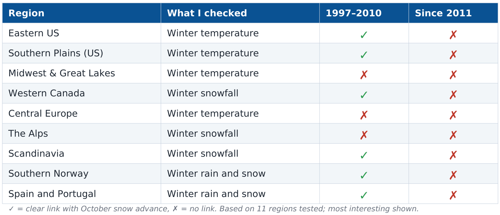
Summary of Regional Impacts for North America and Europe
If a stratospheric warming event materializes in early 2027, historical analogues and current ensemble modeling suggest distinct regional outcomes:
- United States: The prevailing Super El Niño signal, combined with a potential Polar Vortex disruption, points toward a colder, highly active storm track across the central, southern, and eastern United States. Persistent cloud cover and precipitation driven by an amplified Pacific jet stream are expected to suppress temperatures across the southern tier.
- Canada: Milder-than-average conditions are favored across parts of eastern Canada, as displaced cold air routes southward into the United States.
- Europe: Current late-winter forecasts for Europe lean toward a predominantly milder Atlantic flow, with core cold anomalies largely restricted to northern Scandinavia. Unlike North America, Europe does not currently exhibit a strong surface-level cold response in the seasonal modeling.
Ultimately, while the legendary Siberian snow advance theory provided a fascinating chapter in modern meteorology, empirical data proves it has transitioned from a reliable forecasting signal to an unreliable relic of the past. For Winter 2026/2027, forecasters will leave the snow-cover gauges behind and focus on the roaring engine of the Pacific Super El Niño and the real-time pulse of the stratosphere.
