

EUROPE — Meteorological authorities and severe weather forecasters have issued urgent warnings for a major severe weather outbreak spanning the north-central Mediterranean and the Adriatic Sea region. Driven by a volatile combination of extreme seasonal heat, high moisture content, and robust atmospheric instability, the incoming storm system poses a multifaceted threat to millions of residents and peak-season tourists across southern and central Europe.
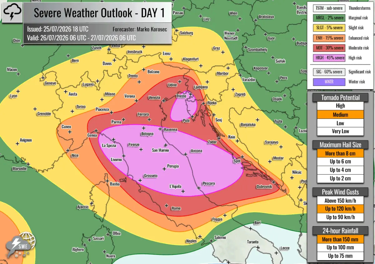
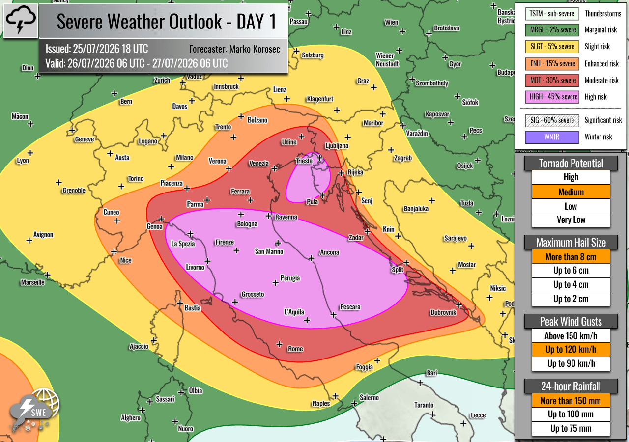
Issued by Severe Weather Europe and led by forecaster Marko Korošec, the valid meteorological outlook covers the 24-hour period from 06:00 UTC on July 26, 2026, to 06:00 UTC on July 27, 2026. Multiple zones, notably across Italy, Slovenia, and Croatia, have been placed under HIGH and Moderate (MDT) risk levels. The forecast warns of catastrophic hazards, including giant hail exceeding 10 centimeters in diameter, destructive straight-line winds, tornadoes, waterspouts, and catastrophic flash floods fueled by torrential rainfall.
Main Facts: A Volatile Atmospheric Setup
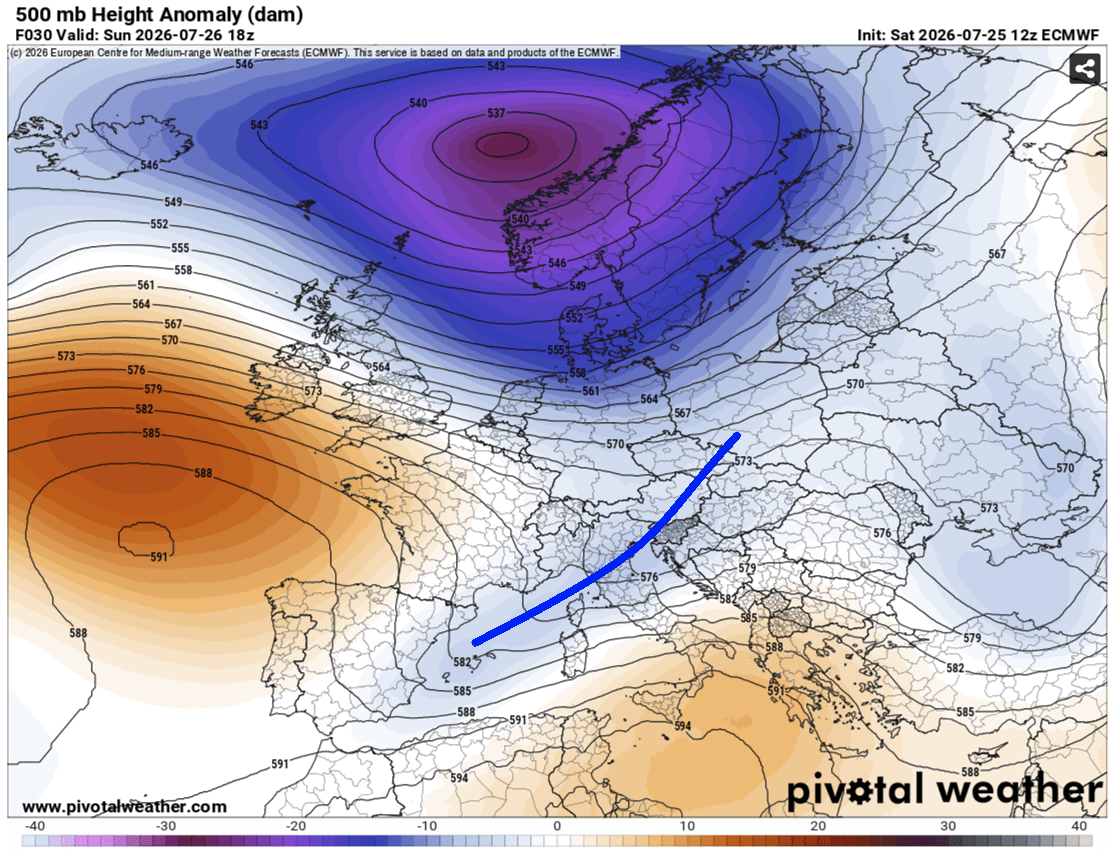
The unfolding weather crisis is the result of a classic, highly volatile synoptic setup dominating the European continent. A stationary, deep upper-level low-pressure system is currently locked over northern Europe, wedged securely between two robust blocking high-pressure ridges stationed over the North Atlantic and Russia.
Further south, a secondary upper-level wave is tracking out of central Europe toward the Mediterranean. At the surface, an extensive low-pressure system centered near western Norway is driving a sprawling frontal boundary southward. As this cold front presses across the Alps and into the northern Mediterranean, it interacts with an ongoing, intense Mediterranean heatwave.
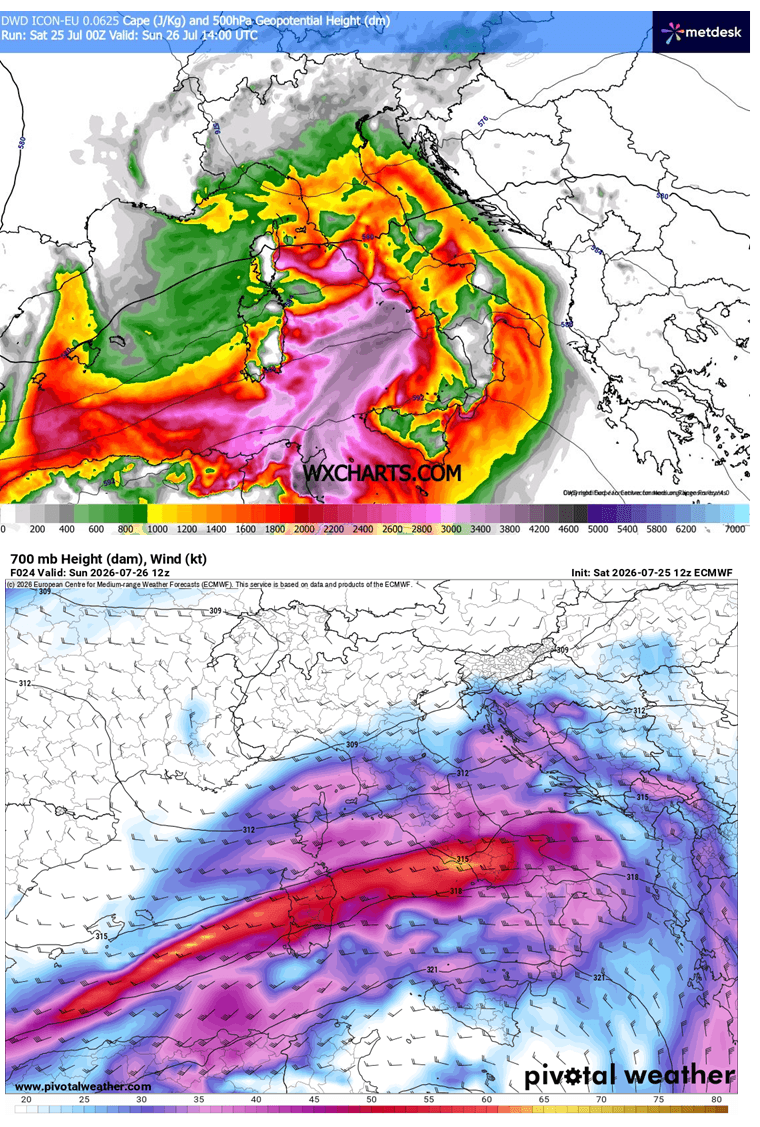
Ahead of the advancing front, powerful south-westerly winds aloft are pumping massive amounts of moisture from the central Mediterranean basin into the north. This influx, paired with high surface dewpoints, has created a thermal powder keg. Mixed-Layer Convective Available Potential Energy (MLCAPE)—a key measure of atmospheric instability—is projected to reach a staggering 2,000 to 3,000+ Joules per kilogram (J/kg) over the Tyrrhenian, Ligurian, and central Adriatic seas.
Simultaneously, a potent mid-level jet stream is injecting strong wind shear into the region. The convergence of extreme instability, intense directional wind shear, and high precipitable water (PWAT) values ranging between 45 and 60 mm creates a textbook environment for the explosive development of severe, organized thunderstorms, including long-lived supercells and training multicell clusters.
Chronology of the Event: Sunday’s Evolving Threat
The severe weather threat is structured to escalate rapidly through Sunday, July 26, impacting different regions in distinct, highly dangerous phases.
Early Morning to Afternoon: Northern Italy and the Apennines
The severe weather event is slated to kick off during the early morning hours of Sunday, erupting initially over the Ligurian Bay. Driven by robust lift near the left-exit region of the upper jet, storms will quickly organize into intense supercells and training multicell clusters. As these systems push eastward across the rugged terrain of the north-central Apennines and into northern Italy, they will encounter high moisture channels, maximizing the risk of torrential downpours.
By midday, the storm systems will begin marching aggressively toward the Adriatic Sea, bringing hazards of destructive winds, large-to-giant hail (measuring 6 to 10+ cm), and localized tornadoes.
Afternoon into Evening: The North Adriatic, Istria, and Slovenia
A secondary focal point of extreme concern centers on the North Adriatic, northwest Croatia (specifically the Istria peninsula), and southwestern Slovenia. Forecasters warn that stationary surface convergence zones will anchor severe storms along the coast.
High-resolution models indicate that these slow-moving or training convective cells could dump localized rainfall accumulations of 100 to 200 mm within a brief 6-to-12-hour window. Because this region is currently packed with tourists during the peak of the summer holiday season, the potential for dangerous, rapid flash flooding along coastal zones and low-lying areas is exceptionally high.
Furthermore, enhanced low-level directional shear and strong southeast low-level flow will maximize the threat of tornadic supercells and waterspouts during the afternoon hours, particularly in the western portions of the high-risk zone and along stalled convergence boundaries.
Supporting Meteorological Data and Regional Breakdown
The breadth of the meteorological threat extends far beyond the primary high-risk zones, encompassing localized dangers in the western Mediterranean and parts of eastern Europe.
High-Risk Zones (HIGH)
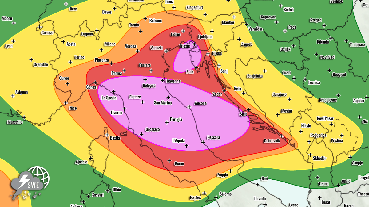
- Central and Northern Italy & Central Adriatic Sea: Placed under a HIGH risk due to a compounding threat of severe damaging winds, very large to giant hail, torrential rainfall leading to severe flash floods, and a notable frequency of tornadoes.
- Northeast Adriatic Sea, Northwest Croatia (Istria), & Southwestern Slovenia: A second HIGH risk area issued primarily for excessive, torrential rainfall capable of triggering catastrophic flash floods, alongside severe winds, large hail, and waterspouts or land-falling tornadoes.
Surrounding Threat Zones (MDT, ENH, SLGT)
Surrounding the core high-risk corridors, Moderate (MDT), Enhanced (ENH), and Slight (SLGT) risks have been established across western and southern Croatia, western and central Slovenia, west-central Austria, southern Switzerland, and north-central Italy. While overall storm coverage may be slightly lower than in the core purple risk areas, individual cells will still carry significant risks of severe winds, large hail, and heavy rainfall.
Western Mediterranean and Eastern Europe
- Spain and the Balearic Islands: An ENH risk has been declared for the western Mediterranean, where isolated severe storms between northeast Spain and the Balearic Islands could produce severe winds, large hail, and torrential downpours.
- Northern Europe & Central Europe: Along the southern edge of the primary upper wave—stretching from the Netherlands across northern Germany into Poland—a SLGT risk highlights the potential for localized severe winds and marginal hail.
- Southwestern Russia: A large ENH/SLGT risk zone has been activated, driven by strong instability and a heavily sheared environment. This region faces discrete, organized supercells capable of producing damaging winds, torrential rain, large hail, and a measurable tornado threat owing to enhanced low-level helicity.
Official Responses and Civil Protection Preparedness
With millions of residents and holidaymakers situated in the direct path of the projected outbreak, national civil protection agencies, local emergency services, and meteorological institutes across Italy, Slovenia, and Croatia have gone on high alert.
Emergency management teams have begun issuing localized weather advisories, urging the public to secure outdoor property, temporary structures, and vehicles against the threat of destructive winds and giant hail. Coastal authorities in Croatia and Italy are paying special attention to crowded beaches, campsites, and marine traffic, preparing warnings for fast-moving squalls and sudden waterspout formations that could threaten swimmers and small craft.
Infrastructure operators, including road and rail networks, are staging personnel and equipment to manage potential disruptions caused by flash flooding, downed power lines, and debris-blocked roadways. Emergency services have reiterated that motorists should avoid attempting to drive across flooded roads or low-water crossings, as fast-flowing water can easily sweep away vehicles.
Broader Implications: Infrastructure, Agriculture, and Climate Context
The severe weather outbreak carries profound socioeconomic implications for the affected regions, striking during a delicate period for agriculture, tourism, and energy infrastructure.
Agricultural Vulnerability
The timing of the storm system could devastate regional agriculture. The threat of giant hail (exceeding 10 cm in diameter) and violent convective winds presents an existential hazard to vineyards, orchards, and crop fields across northern Italy and the northern Balkans. A direct hit from large hail can wipe out an entire season’s yield in a matter of minutes, leaving farmers facing catastrophic economic losses during the height of the summer growing season.
Tourism and Local Economies
Tourism infrastructure is uniquely vulnerable during this late-July event. Popular coastal destinations in Istria, the Dalmatian coast, and the Italian lakes region are operating at maximum capacity. Flash flooding in coastal towns, campgrounds, and urban centers poses immediate life-safety risks to unprepared travelers, while widespread power outages and infrastructure damage could disrupt regional transportation networks for days.
Climate and Synoptic Context
Meteorologists note that this event underscores the increasingly volatile nature of European summer weather, where persistent atmospheric blocking patterns trap heat waves in place until energetic upper-level troughs force violent, explosive relief. The extreme moisture feed from a super-heated Mediterranean basin acts as an abundant fuel source, supercharging convective systems and turning routine cold fronts into high-impact, multi-hazard severe weather outbreaks.
As the weather systems continue to organize, authorities strongly advise the public to monitor real-time radar, local meteorological warnings, and civil protection alerts as the severe weather event unfolds.
