

GENEVA/PARIS/BERLIN — Meteorological agencies and severe weather experts across Europe are on high alert as a powerful, multi-day severe weather outbreak targets large swaths of the continent. Issuing critical warnings for Thursday, August 27, through Friday night, August 28, 2026, forecasters have highlighted an explosive combination of extreme instability, intense wind shear, and moisture streaming northward from a heatwave-stricken Mediterranean.
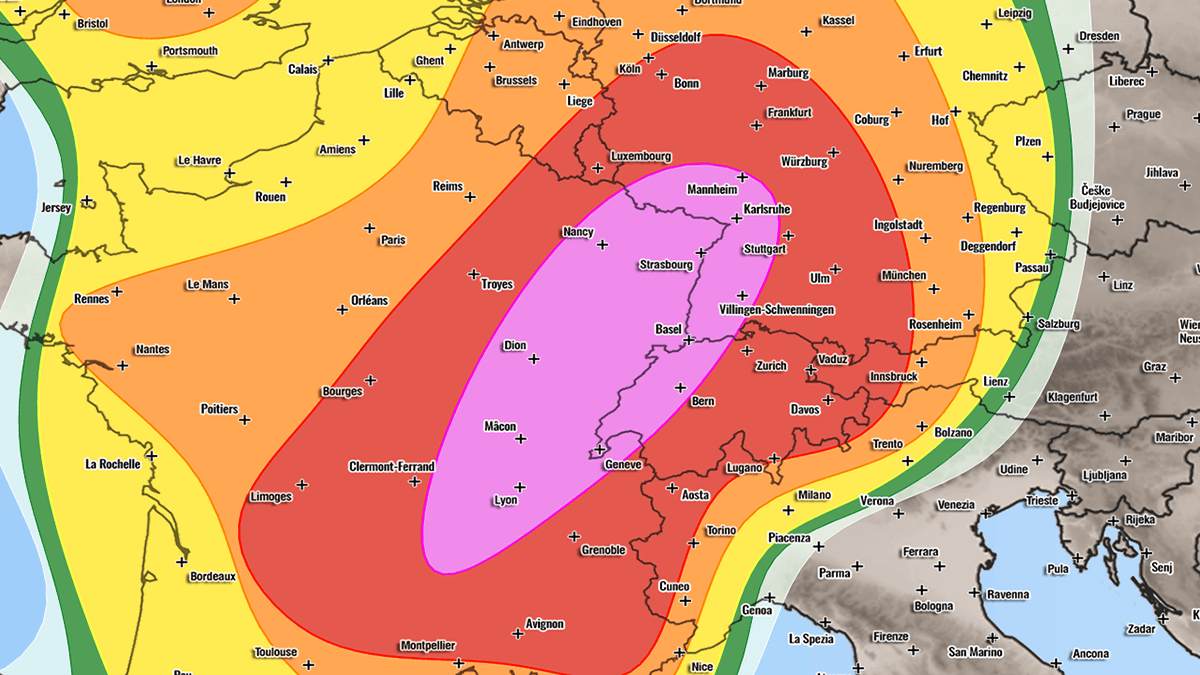
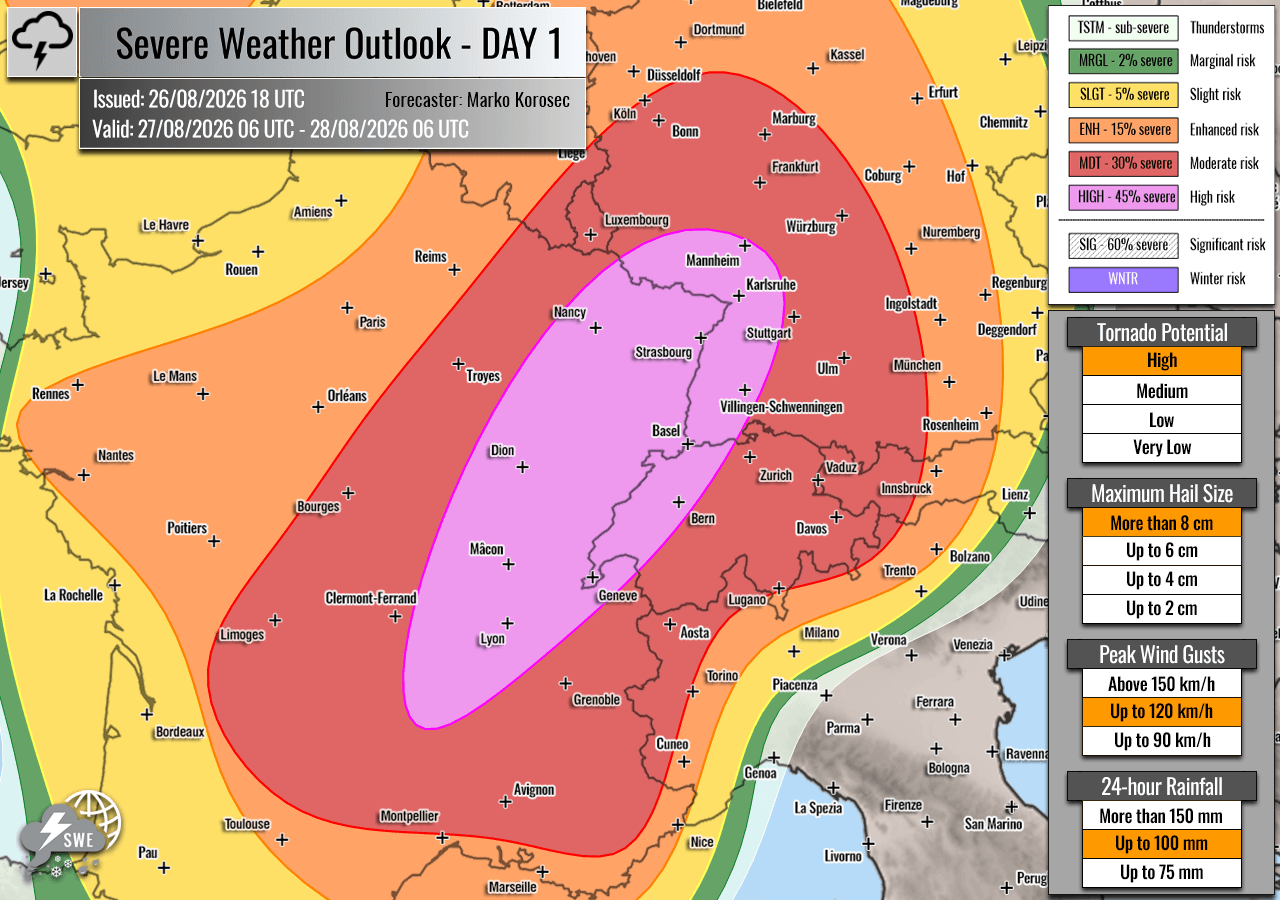
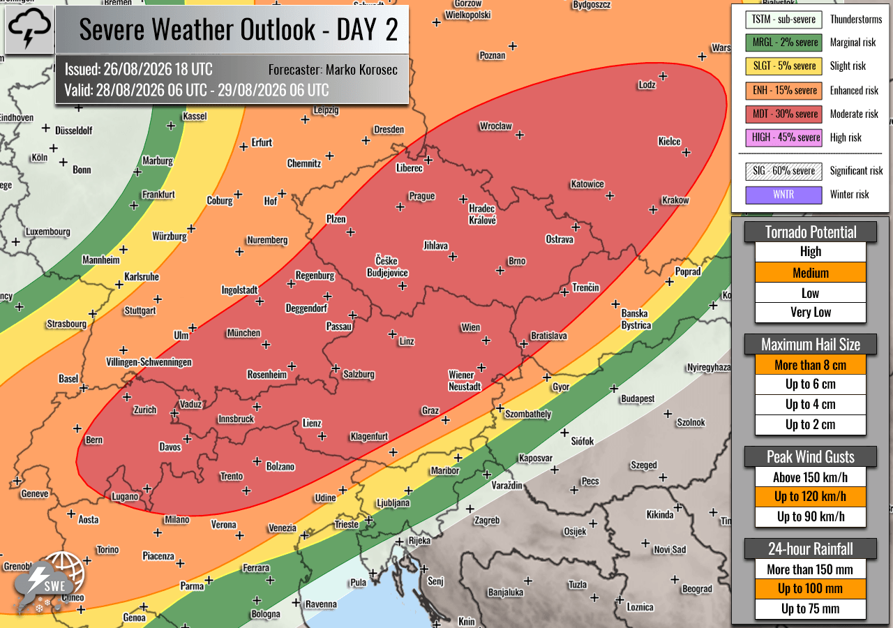
The severe weather threat encompasses a vast geographic footprint, stretching from eastern and southern France across western Switzerland, southwestern Germany, Austria, the Czech Republic, and into southwestern Poland. Authorities have designated HIGH and Moderate (MDT) risk areas, warning residents and local emergency management teams to prepare for destructive hazards, including giant hail measuring up to 10 centimeters or larger, severe damaging straight-line winds exceeding 120 km/h, torrential downpours leading to flash floods, and potential tornadoes.
Main Facts: The Anatomy of an Approaching Storm System
The impending severe weather episode is driven by a classic, high-impact synoptic setup characteristic of late-summer convective extremes in Europe.
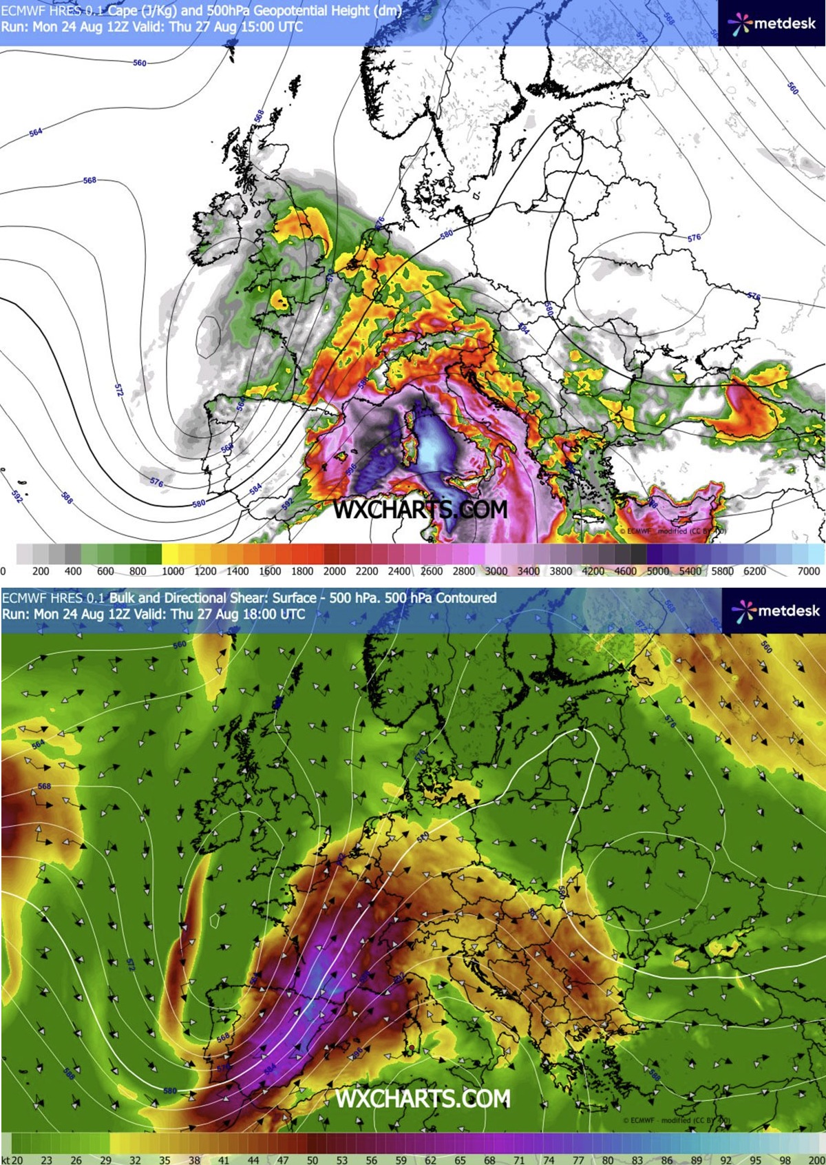
- The Trigger: A large, deep upper-level trough is rapidly digging into Western Europe. Simultaneously, a robust blocking high-pressure system remains firmly entrenched over the Mediterranean region and the Balkans.
- The Energy: Wedged between these two massive pressure systems is a powerful southwesterly jet stream. This jet is pumping an extremely warm, highly humid air mass northward from the Mediterranean—a region currently gripped by severe, persistent heatwaves.
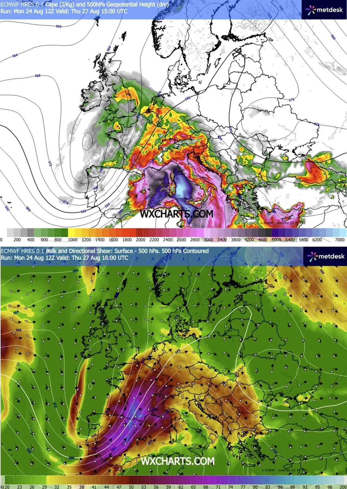
- Instability and Shear: In the lower and mid-troposphere, MLCAPE (Mixed-Layer Convective Available Potential Energy) values are forecast to surge between 2,000 and 4,000+ J/kg, particularly across southeastern France. When combined with violent wind shear generated by the jet stream, the atmosphere will possess explosive potential for organized, long-lived supercells.
- Primary Threats: The hazards are severe and widespread. Forecasters emphasize the threat of very large to giant hail (6–10 cm+), which can severely damage vehicles and infrastructure; destructive straight-line winds capable of downing power lines and trees; torrential rainfall threatening sudden flash floods; and an elevated risk of tornadoes, particularly in areas maximizing low-level shear and storm-relative helicity.
Synoptic Overview: A Clash of Air Masses
To understand the severity of the upcoming 48 hours, meteorologists point to the stark contrast between the deepening upper-level trough over western Iberia and the stubborn ridge anchored over the Mediterranean and Central Europe.
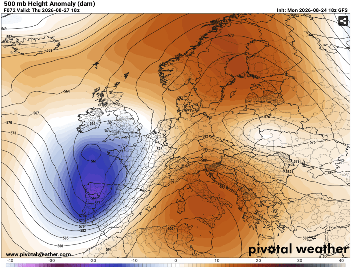
This juxtaposition creates a steep pressure and temperature gradient. As the upper-level trough progresses eastward, it forces a potent frontal system across France, with a cold front translating steadily toward Germany and the Alpine corridor from Thursday midday through Friday night.
Ahead of this approaching front, intense mid-level winds are interacting with rich surface moisture. The left-exit region of the upper-level jet stream will provide exceptional dynamic lifting, encouraging widespread air parcel ascent. The resulting environment is primed for the rapid initiation of violent thunderstorms that will evolve from isolated supercells into large, destructive convective clusters.
Chronology of the Outbreak
Day 1: Thursday, August 27 — France, Switzerland, and Germany
The severe weather outbreak kicks off in earnest on Thursday afternoon.
- Midday Initiation (12:00 UTC onward): The volatile mix of extreme CAPE and intense wind shear will trigger the explosive development of thunderstorms over the Massif Central in France. As these storms push into the Rhône Valley, where southerly winds are funneling maximum low-level moisture, they are expected to quickly organize into discrete, rotating supercells.
- The Tornado Threat: Forecasters have highlighted the Rhône Valley within the HIGH risk zone as a primary target for tornadic activity. Enhanced low-level shear and high storm-relative helicity in this corridor create a favorable environment for brief, intense tornadoes.
- Late Afternoon to Evening Progression: These supercells will race east-northeastward at high speeds, driven by the robust steering currents aloft. They will cross into western Switzerland and southwestern Germany by early evening.
- Transition to Clusters: As night falls, individual supercells are expected to merge into large convective clusters or Mesoscale Convective Systems (MCS). Moving into central and southwestern Germany, the primary hazards will transition toward destructive wind-driven hail, widespread damaging straight-line winds, and torrential rainfall.
- Secondary Threat Areas: To the north of the primary wave axis, secondary storm activity is projected to impact the Benelux region and western Germany by late afternoon and evening, bringing threats of heavy rain and localized damaging winds. Southern England may also experience isolated severe storms during peak afternoon heating.
Day 2: Friday, August 28 — The Alps, Central Europe, and Poland
The focus of the severe weather shifts eastward on Friday as the cold front pushes deeper into Central Europe.
- Early Afternoon Initiation: Isolated thunderstorms will ignite over the Alpine terrain early Friday afternoon, fueled by lingering moderate instability and strong upper-level steering flow. Initially, storms will take the form of intense multi-cells and supercells.
- The MCS Threat: By Friday evening, considerable uncertainty remains regarding the exact organization of a potential large-scale Mesoscale Convective System (MCS) sweeping from southeastern Germany and northeastern Austria into the southwestern Czech Republic. High-resolution numerical models suggest that bowing segments within these clusters could organize into a violent wind-gust corridor.
- Overnight Expansion: If this severe squall line fully materializes, destructive straight-line winds could exceed 120 km/h, causing widespread structural and agricultural damage across the Moderate (MDT) risk zone before pushing northeastward into southwestern Poland overnight.
Supporting Data and Risk Mapping
Forecasters from Severe Weather Europe, alongside data inputs from high-resolution models analyzed via Meteoadriatic, Wxcharts, and PivotalWeather, have clearly delineated the zones of highest concern:
- HIGH Risk Zones (Thursday): Encompassing east-central France, western Switzerland, and southwestern Germany. This zone bears the highest probability for a destructive severe weather outbreak featuring all primary hazards: giant hail, destructive winds, flash floods, and tornadoes.
- Moderate (MDT) Risk Zones (Thursday/Friday): Surrounding the core high-risk areas on Thursday (including northwestern Italy, western Austria, the Benelux, and central/northern Germany) and shifting to eastern Switzerland, Austria, the Alpine region, the Czech Republic, and southwestern Poland on Friday. Storm coverage may be slightly more scattered than in the core high-risk zone, but individual storm intensity remains profoundly dangerous.
- Enhanced (ENH) and Slight (SLGT) Risk Zones: Serving as buffers to the core threat areas, these zones face risks of localized severe winds, large hail, and torrential rainfall.
Official Responses and Preparedness
National meteorological services—including Météo-France, Germany’s DWD, MeteoSwiss, Austria’s GeoSphere Austria, and meteorological institutes in the Czech Republic and Poland—have begun issuing yellow, orange, and red weather warnings.
- Civil Protection: Emergency management authorities are urging citizens in the affected zones to secure outdoor property, vehicles, and recreational equipment ahead of the storms. Municipalities are cleaning storm drains to mitigate the risk of urban flash flooding.
- Transportation and Aviation: Major European transport hubs, including airports in Frankfurt, Zurich, Lyon, and Prague, are warning passengers of potential flight delays, cancellations, and ground stops as severe convective cells pass through busy air corridors. Rail networks are also preparing for potential disruptions caused by downed trees and power outages.
- Public Advice: Residents within the HIGH and MDT risk zones are strongly advised to monitor real-time radar updates, heed local emergency alerts, and identify sturdy shelter locations within their homes or workplaces ahead of the storm arrivals.
As Europe navigates this high-impact meteorological event, forecasters emphasize that timely preparation will be the key to mitigating the risks posed by this severe multi-day outbreak.
