

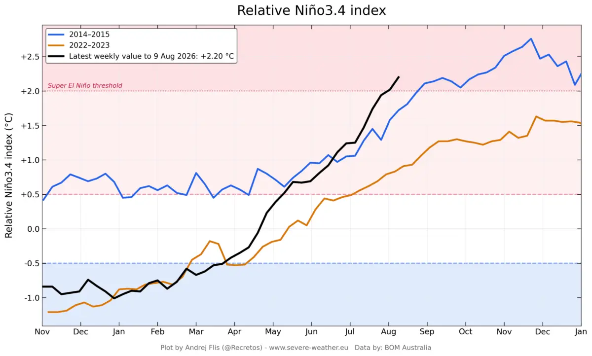
GLOBAL CLIMATE UPDATE — A rapidly developing "Super" El Niño is aggressively reshaping global atmospheric circulation across the tropical Pacific, with new ocean and atmospheric data revealing an unprecedented acceleration in its development. Latest long-range forecasts from leading global meteorological centers, including the European Centre for Medium-Range Weather Forecasts (ECMWF) and the National Oceanic and Atmospheric Administration (NOAA), have once again raised projected peak intensities. This trajectory pushes the unfolding 2026 event deeper into historic territory, with profound implications for weather patterns across the United States, Canada, and Europe through the upcoming Fall 2026 and Winter 2026/2027 seasons.

1. Main Facts: The Anatomy of a Super El Niño
At its core, El Niño is a climate phenomenon characterized by the warming of sea surface temperatures across the central and eastern tropical Pacific. However, when an event crosses into "Super" status—typically defined by sea surface temperature anomalies reaching or exceeding +2.0°C above the long-term average—it ceases to be a regional anomaly and becomes a primary driver of global weather systems.
The current 2026 event is displaying energy signatures that exceed most, if not all, previously recorded super events.
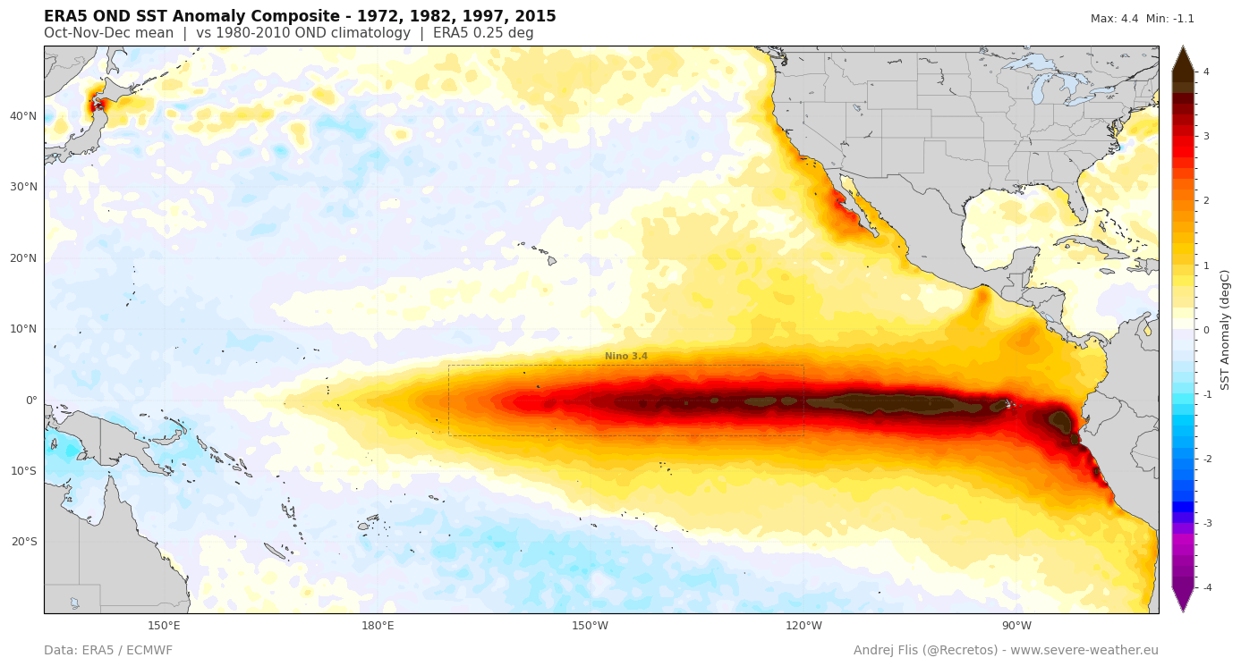
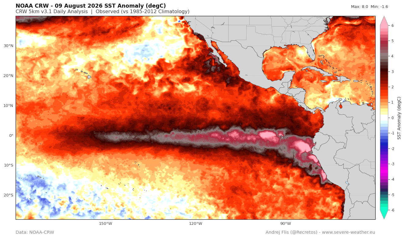
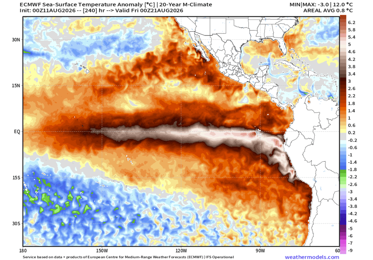
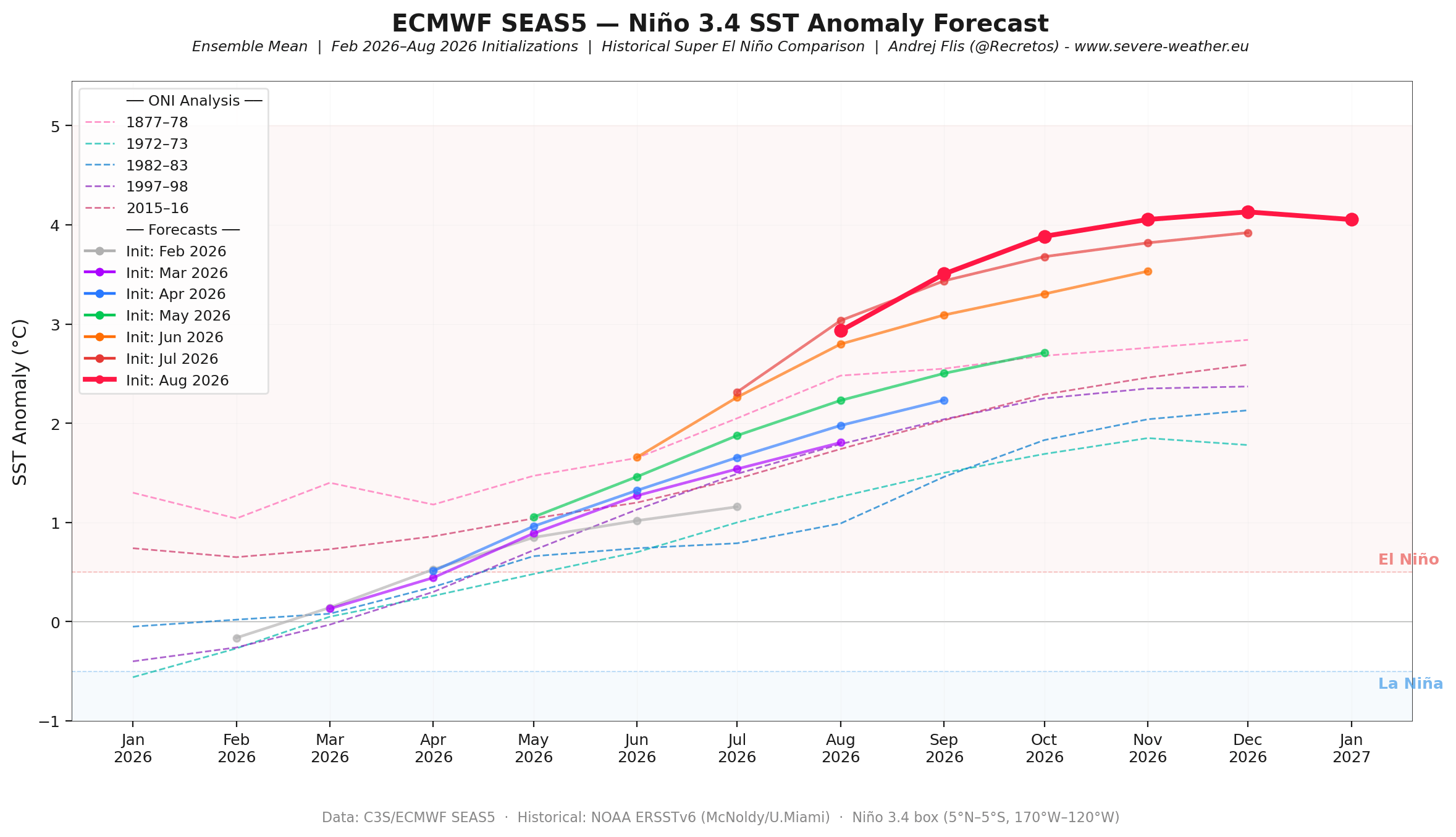
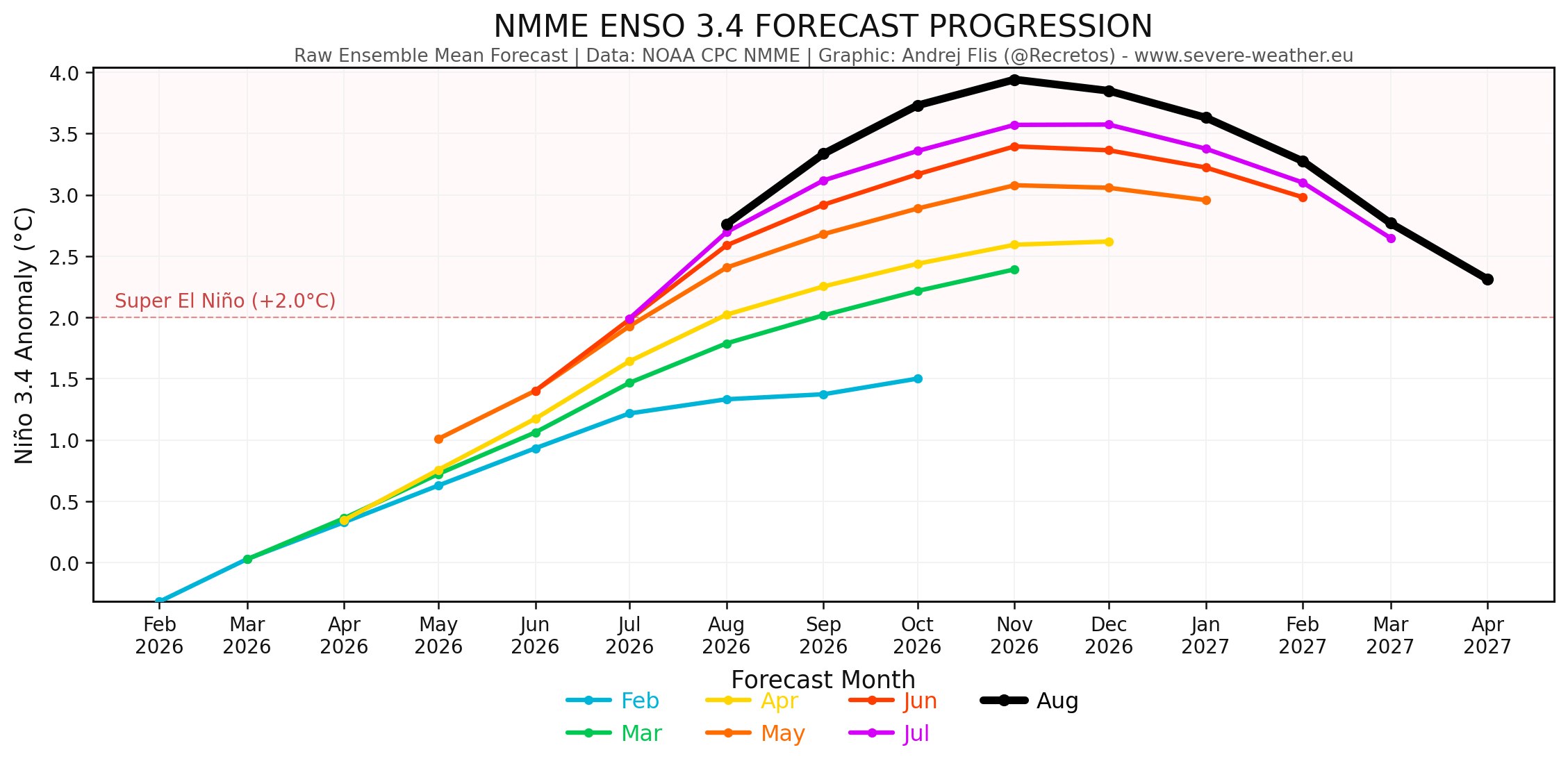
- Unprecedented Intensity: The latest operational runs from the ECMWF and NOAA’s North American Multi-Model Ensemble (NMME) project peak anomalies in the central-eastern equatorial Pacific to cruise past the unofficial +3.0°C threshold, with localized eastern anomalies surging past +5.0°C to +7.0°C.
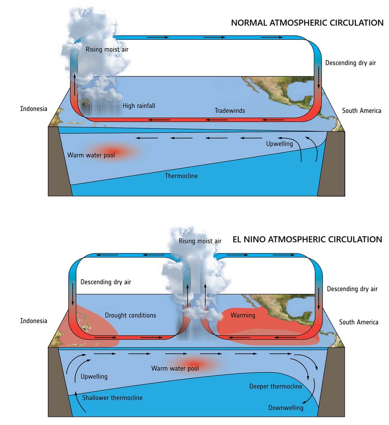
- The Atmospheric Response: The phenomenon is governed by the Walker Circulation—the loop of trade winds and air currents traversing the tropical Pacific. Under normal conditions, warm water piles up in the western Pacific. During a Super El Niño, a massive pressure drop in the central and eastern Pacific clashes with high-pressure zones in the west, locking the atmosphere into a permanent, stationary "standing wave."
- Global Teleconnections: This atmospheric reconfiguration alters the jet stream, directly impacting storm tracks, precipitation potential, and temperature anomalies from North America to Europe.
2. Chronology of Development: From Spring Acceleration to Late-Summer Surge
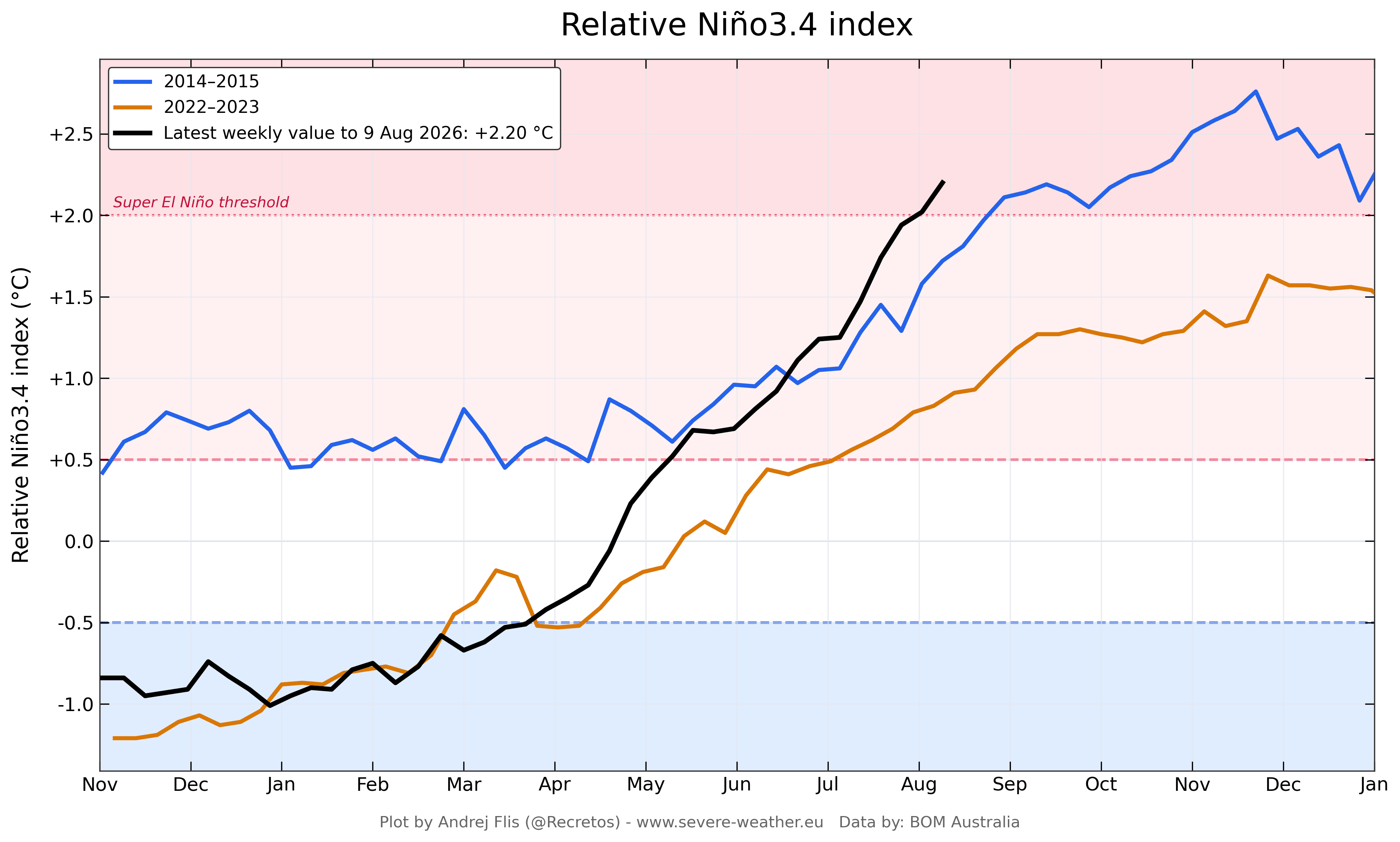
The evolution of the 2026/2027 El Niño has caught forecasters off guard due to its blistering speed, shattering historical benchmarks established during previous extreme events like the 2015–2016 Super El Niño.
Spring to Early Summer: The Catalyst
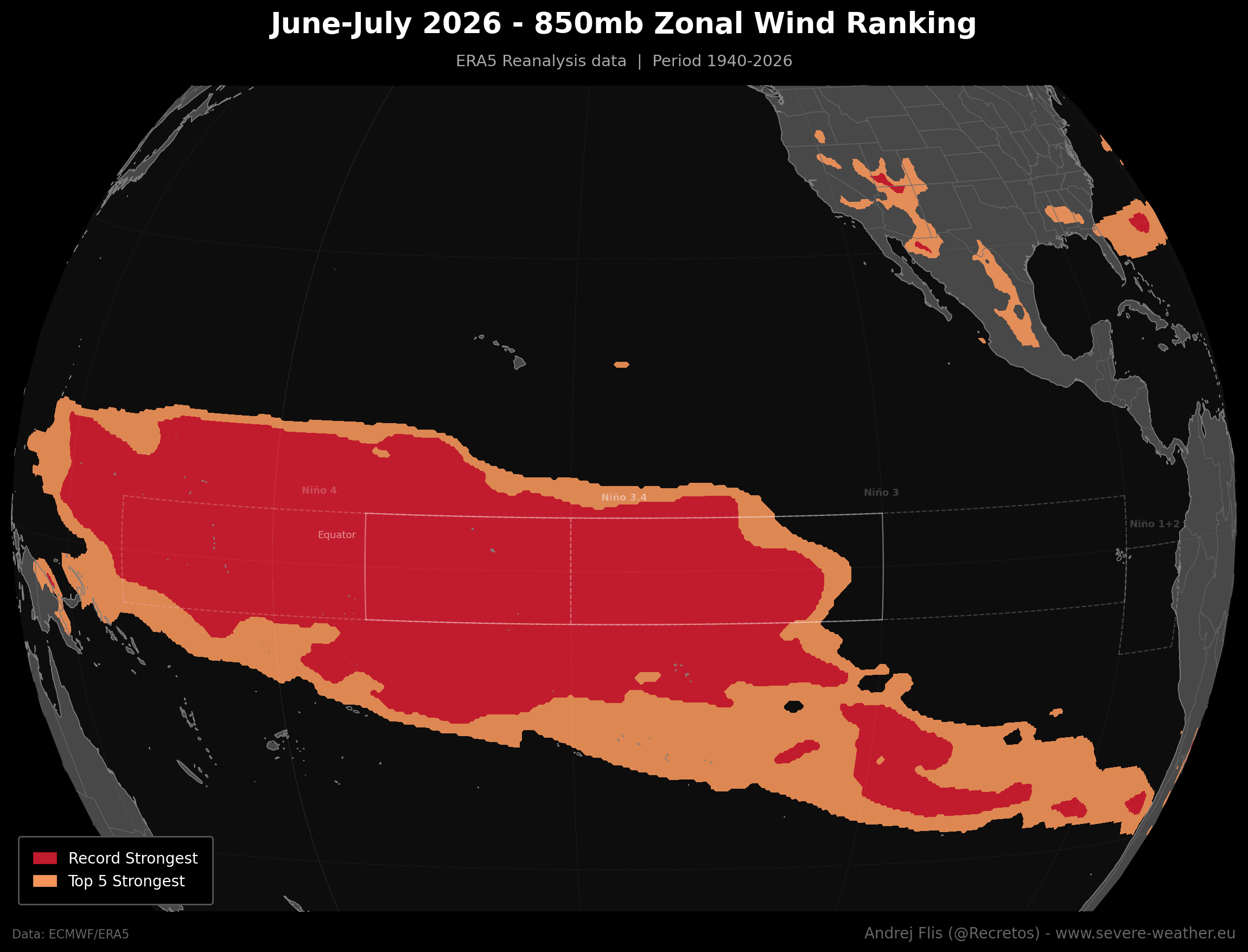
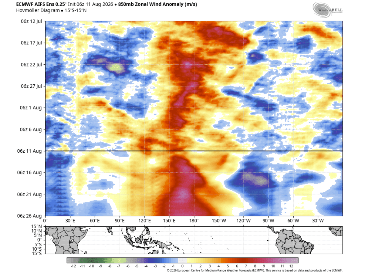
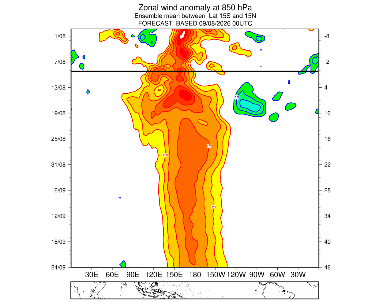
Following a relatively neutral or cool baseline in early spring (registering a cool -1 on the Multivariate ENSO Index in February-March), the tropical Pacific experienced an abrupt meteorological shift. Sustained trade wind collapses triggered massive low-level westerly wind anomalies across the western and central equatorial Pacific throughout June and July. ERA5 reanalysis data indicates that these June-July zonal wind rankings broke 86-year historical records for persistence and breadth.
Mid-Summer: Subsurface Kelvin Waves Erupt
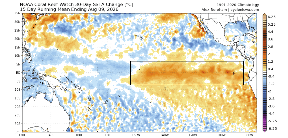
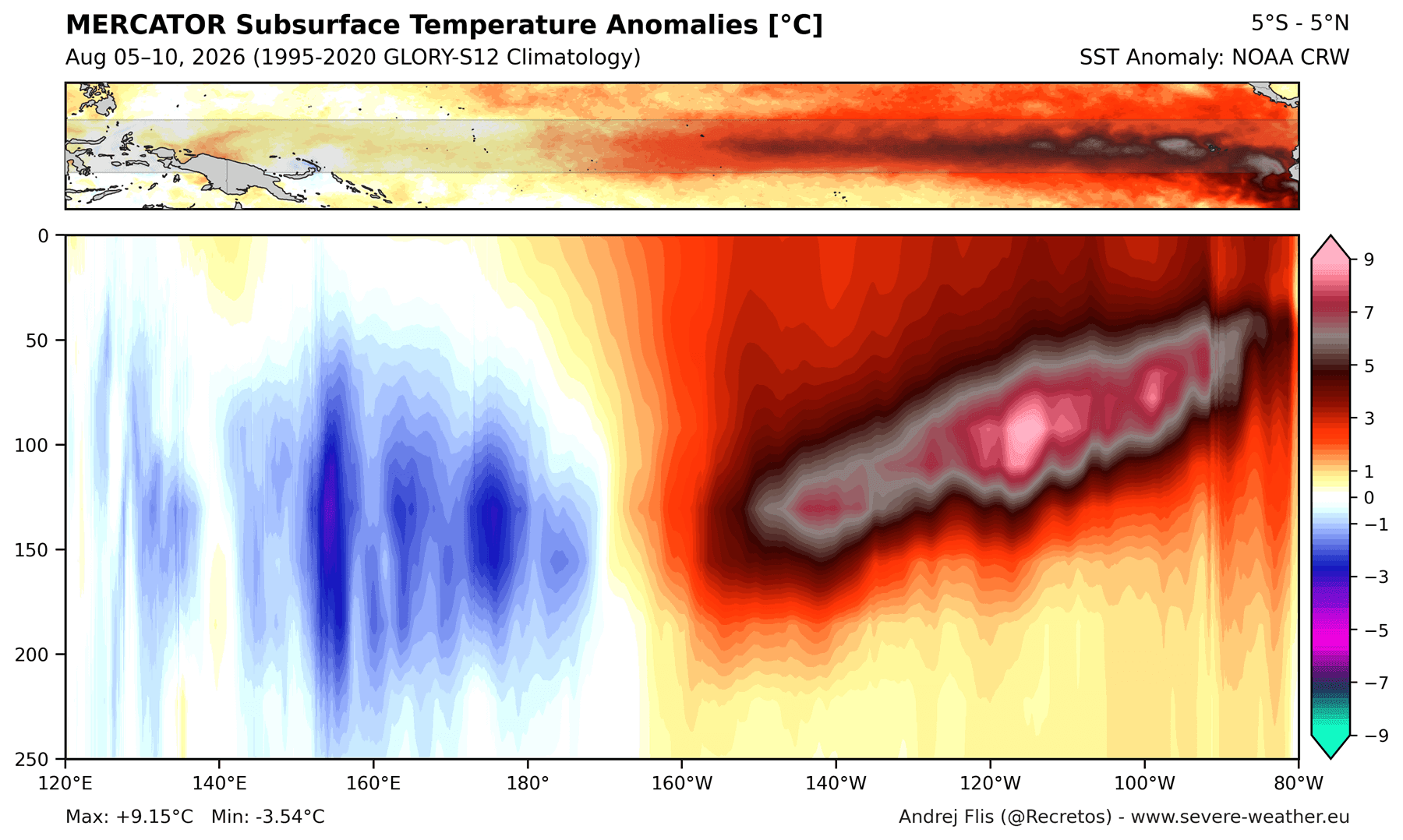
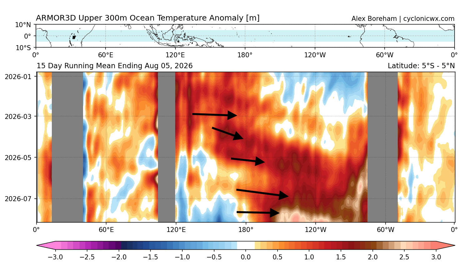
The unprecedented westerly wind bursts acted as an engine, physically pushing warm subsurface water eastward. This generated a powerful downwelling Kelvin Wave—a thick layer of subterranean thermal energy plunging up to 250–300 meters deep, with core temperature anomalies exceeding +9.0°C (+16°F) above normal. As this immense pocket of heat steadily migrated eastward and rose toward the surface, it provided a continuous, uninterrupted supply of thermal energy, supercharging surface sea temperatures through July and August.
Late Summer Forecasts: Pushing into Uncharted Territory
Because seasonal forecast models historically struggle to simulate individual, chaotic westerly wind bursts in advance, initial models drastically underpredicted the speed of this event. However, as the physical data caught up, consecutive model runs since February have continuously trended upward. The latest mid-August updates confirm that the 2026 event is developing at a pace unmatched in modern record-keeping, locking in high-amplitude atmospheric forcing well ahead of the traditional autumn transition.
3. Supporting Data and Meteorological Metrics
Meteorologists rely on a suite of coupled ocean-atmosphere indices to gauge the structural integrity of an El Niño event. For the 2026 cycle, every major metric points toward extreme behavior.
NOAA’s Multivariate ENSO Index (MEI.v2)
The MEI combines both marine and atmospheric data into a singular, comprehensive index. According to NOAA Physical Sciences Laboratory data, the June-July (JJ) bi-monthly MEI value for 2026 surged to a record-high +2.4. This represents an astonishing +3.4-point jump over just four reporting periods. Values exceeding +2.0 are exclusively reserved for generational El Niño events, and achieving this magnitude as early as mid-summer is completely unprecedented in the observational record dating back to 1979.
Ocean Heat Content and Velocity Potential
Satellite altimetry and subsurface buoy networks show that the Pacific Ocean heat content anomaly has expanded dramatically. The Velocity Potential parameter from GDAS data confirms a massive, entrenched zone of rising air (teal anomalies) centered squarely over the central and eastern tropical Pacific, offset by stable sinking air (brown anomalies) over the Indian Ocean. This establishes the classic, highly reinforced Walker Cell stagnation pattern.
4. Official Responses and Scientific Consensus
Global forecasting agencies have adjusted their alert levels and monitoring protocols to account for the extraordinary nature of the 2026 event.
- ECMWF and NOAA Alignments: In their latest ensemble guidance, European and North American meteorological institutions emphasize that the coupling between the ocean and the atmosphere is exceptionally robust. Unlike moderate El Niño events—which often experience disruptions from chaotic mid-latitude weather variability—this Super El Niño possesses enough thermodynamic momentum to completely dominate the Northern Hemisphere’s winter jet stream.
- Published Analyses: Specialized climate researchers note that the presence of secondary oceanic anomalies interacting with the Pacific basin may further amplify the atmospheric response, driving distinct hydrological adjustments across both North America and Eurasia. Climate attribution studies are already underway to assess how background global warming trends interact with naturally occurring decadal cycles to facilitate such rapid super-charging.
5. Seasonal Implications: Fall 2026 and Winter 2026/2027 Outlooks
The ultimate downstream effect of a Super El Niño manifests across North America and Europe through distinct shifts in temperature, precipitation, and snowfall regimes.
United States and Canada: Fall Transition
Typically, El Niño impacts take time to filter into mid-latitude weather patterns. However, due to its early intensity, the Fall 2026 forecast already exhibits a mature signature.
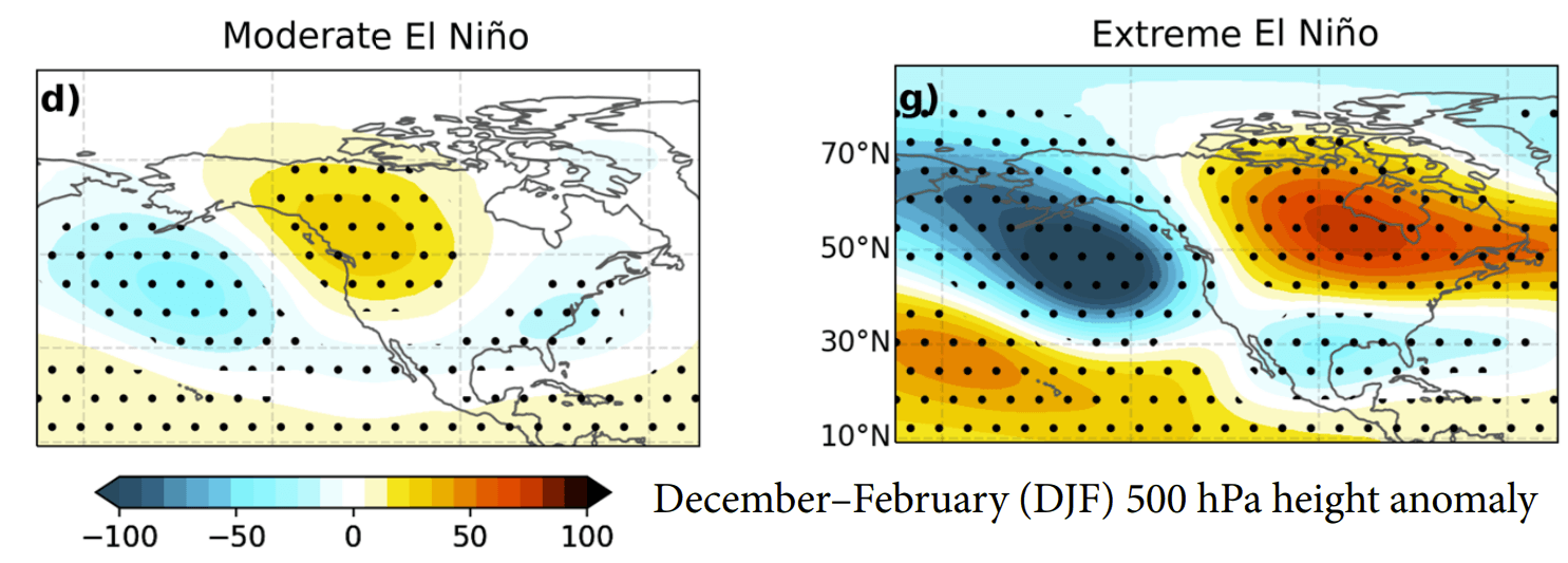
- Pressure Patterns: A prominent high-pressure blocking anomaly is establishing itself over Canada, working in tandem with a deep Pacific low-pressure trough and an active train of low-pressure systems tracking across the southern United States.
- Precipitation: Enhanced rainfall is projected across the southern tier and the U.S. Southeast, fueled by an amplified Pacific jet stream. Conversely, drier-than-average conditions are expected across the Pacific Northwest and southern Canada.
- Temperatures: Mild conditions will dominate under the Canadian high-pressure shield, while temperatures remain closer to seasonal norms across the south-central and eastern U.S. due to persistent cloud cover and storm activity.
United States and Canada: Winter 2026/2027 Deep-Dive
As the winter season peaks between December 2026 and February 2027, the Super El Niño atmospheric bridge will hit maximum amplitude.
- The Jet Stream Highway: The classic El Niño configuration features a northern ridge keeping western Canada and the U.S. Pacific Northwest mild and dry, while a hyper-active southern branch of the jet stream delivers heavy moisture to the Gulf Coast and Southeast.
- Mid-to-Late Winter Shifts (CFSv2 Signals): Emerging forecasts for February 2027 hint at a potential eastward shift in the primary pressure wave. If northern blocking forces a deeper, colder trough over the central and eastern United States, a significant window for cold-air outbreaks and major winter storm setups could open.
- Snowfall Projections: ECMWF seasonal snowfall anomaly models point toward below-average snow totals for the Pacific Northwest, northern Great Lakes, and southern Canada. However, areas from the Central Plains, Midwest, and Mid-Atlantic into the interior Northeast face elevated risks of major winter storms, ice events, and heavy snowfall when southern moisture overrides periodic drops of Canadian air.
Europe: A Milder, Westerly-Dominated Winter
While the direct oceanic footprint of El Niño is centered in the Pacific, its teleconnections reliably ripple across the Atlantic basin.
- Pressure Dynamics: The amplified North American wave pattern forces downstream adjustments, extending low-pressure anomalies into the North Atlantic, the United Kingdom, and northern Europe.
- Temperature and Precipitation: This setup favors a dominant, robust westerly and southwesterly flow from the Atlantic. Consequently, much of central, western, and southeastern Europe is forecasted to experience warmer-than-normal surface temperatures and increased precipitation potential. Broad snowfall across the European continent will likely be limited, restricted primarily to higher elevations and the far northeast, where sporadic northerly dips can tap into colder airmasses.
Looking Ahead
As the 2026/2027 Super El Niño continues its historic march toward its late-autumn peak in November and December, meteorologists globally will closely monitor the stability of the Kelvin waves and atmospheric feedback loops. With societal impacts ranging from agricultural shifts in North America to energy demand fluctuations in Europe, preparedness for this extreme climate driver remains paramount. Further localized and regional updates will be issued as observational data confirms the transition into the core winter season.
