

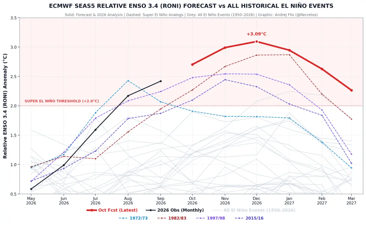
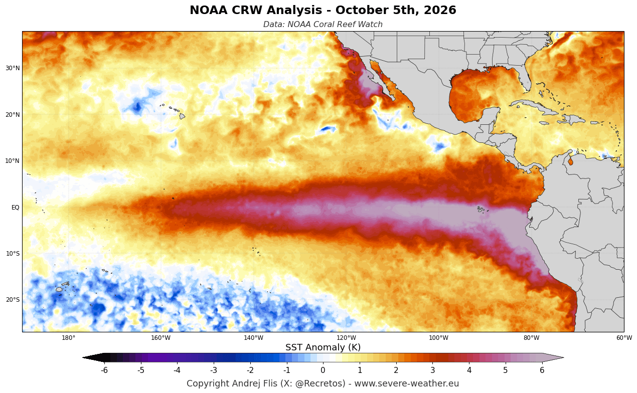
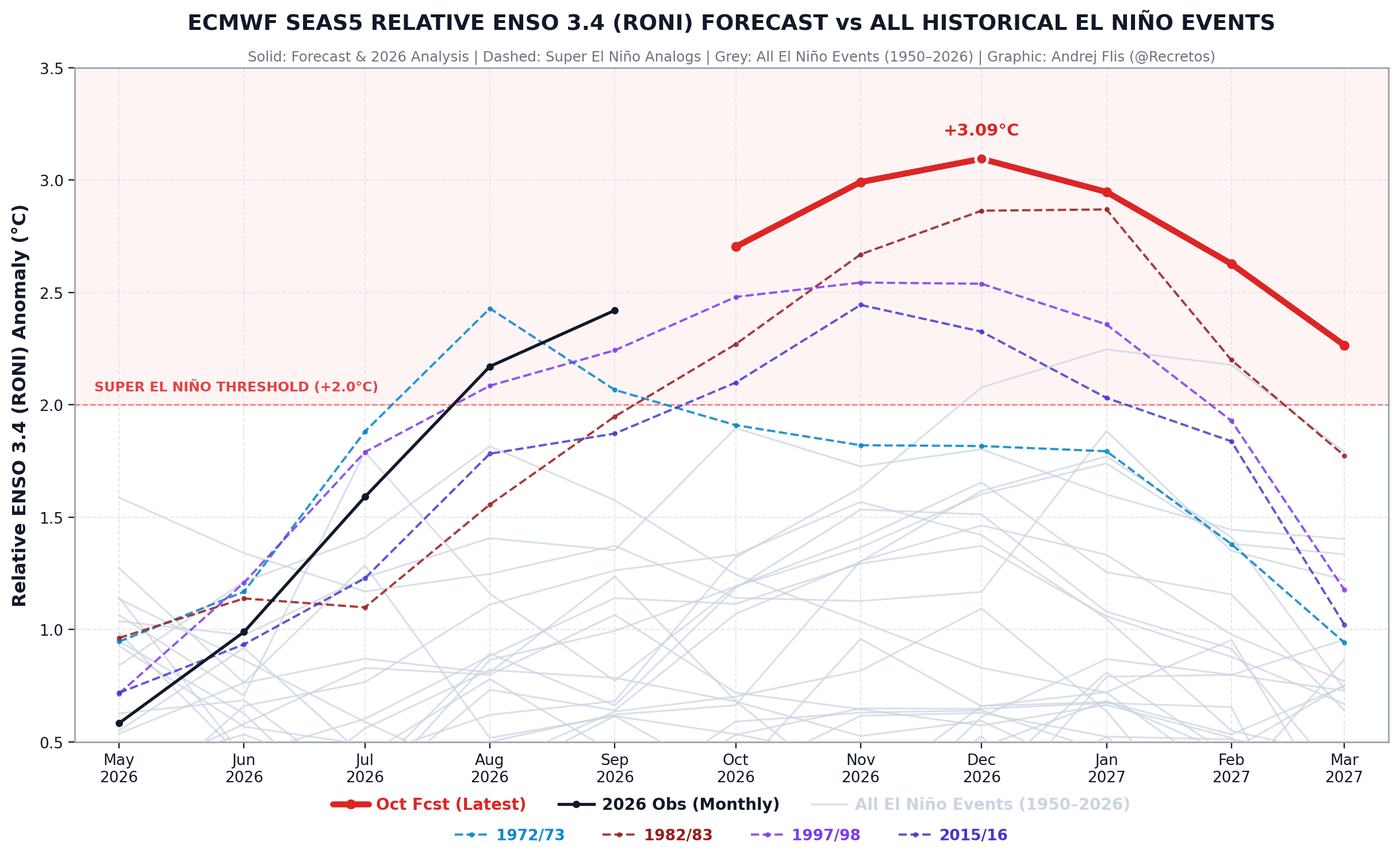
WASHINGTON — Meteorologists and climatologists are sounding the alarm as a historically intense Super El Niño builds rapidly toward its peak for the upcoming 2026/2027 winter season. Fueled by sea surface temperature anomalies running more than 6°C (11°F) above normal in the eastern Pacific, observational data and global climate models—led by the European Centre for Medium-Range Weather Forecasts (ECMWF)—indicate this event is tracking to become the strongest El Niño in over 75 years, eclipsing all benchmarks set since at least 1950.
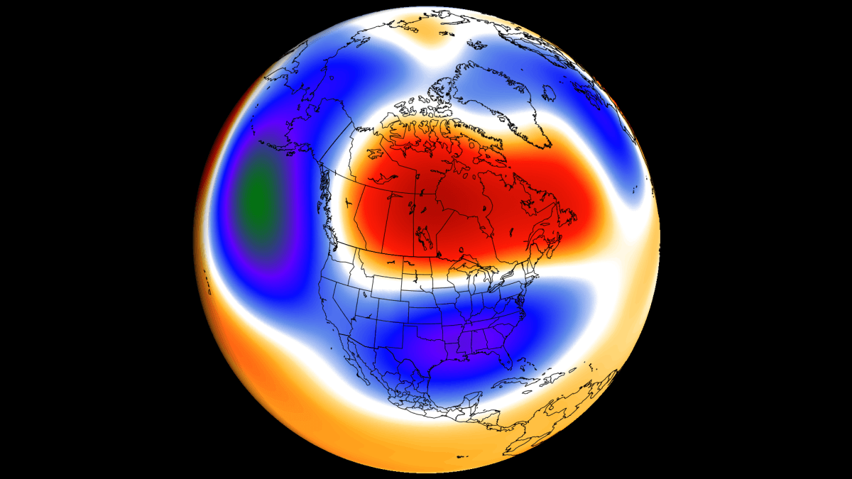
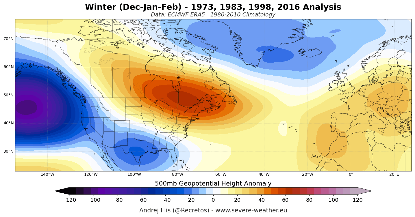
While public perception often associates El Niño winters with universally mild weather, historical precedent proves otherwise. Legendary, paralyzing weather events—such as the massive February 1983 Megalopolitan Blizzard that buried the I-95 corridor and the historic January 2016 East Coast nor’easter—both struck during severe Super El Niño cycles. Latest updates from October forecasting runs point to an amplified, volatile winter pattern characterized by a milder northern tier, a stormy and increasingly snowy south-central and eastern United States, and a dramatic mid-winter disruption of the stratospheric Polar Vortex.
Main Facts: A 75-Year Record Event Takes Shape
The evolving 2026/2027 winter forecast highlights a stark contrast in atmospheric pressure and temperature anomalies driven by unprecedented equatorial Pacific warming:
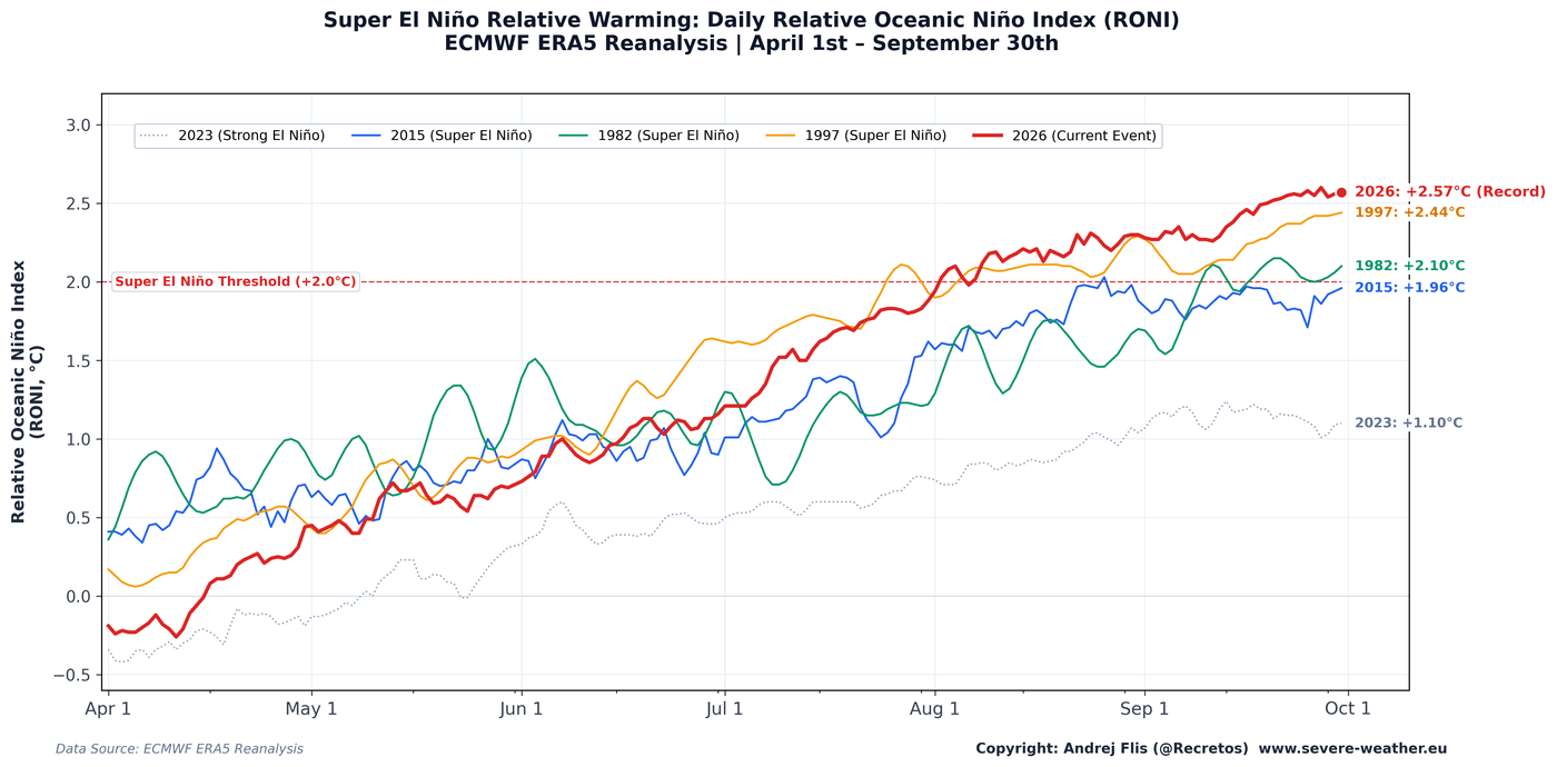
- Unprecedented Intensity: The current El Niño development is running well ahead of historical analogues, tracked via NOAA Coral Reef Watch and ECMWF ERA5 relative oceanic Niño indices. The World Meteorological Organization (WMO) confirms a near-100% probability that the phenomenon will persist at a very strong intensity through the winter months.
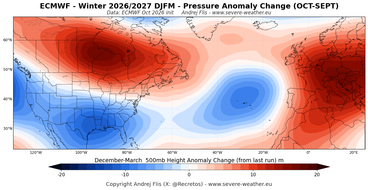
- Pressure Patterns & Jet Stream Shifts: Long-range models project a deep, intense low-pressure zone over the North Pacific that forces a massive blocking high-pressure ridge over Canada and the northern United States. Downstream, an active, moisture-laden southern jet stream establishes itself across the United States.
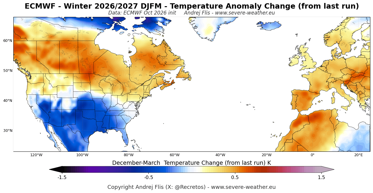
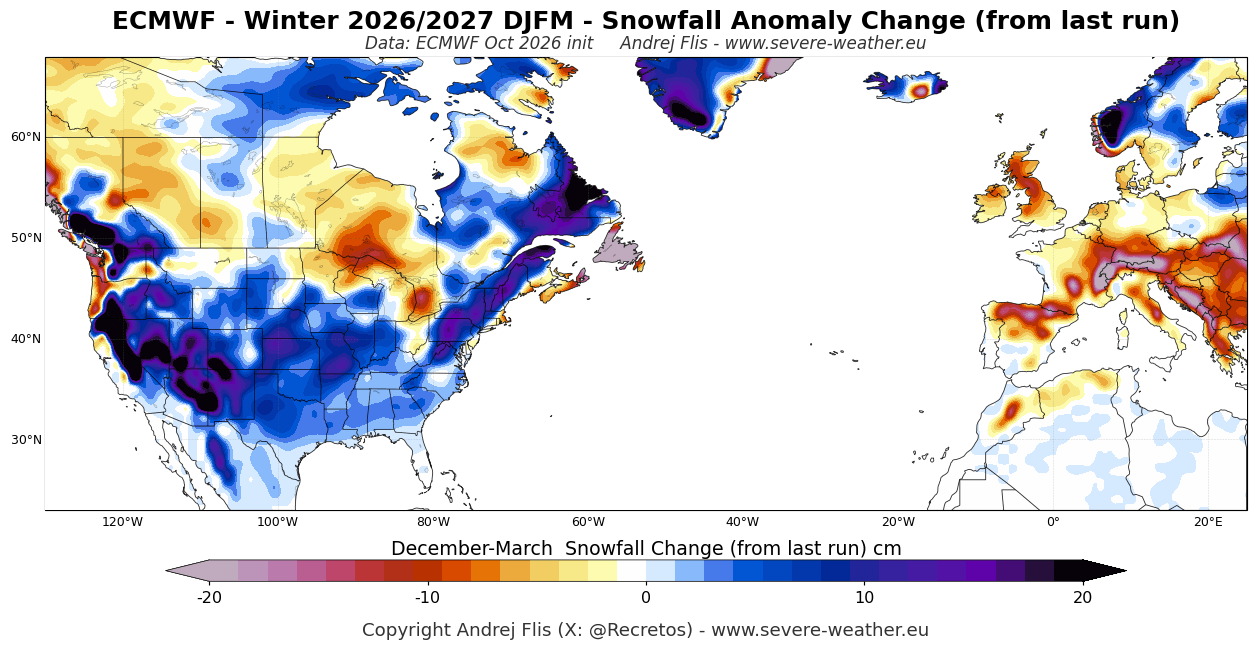
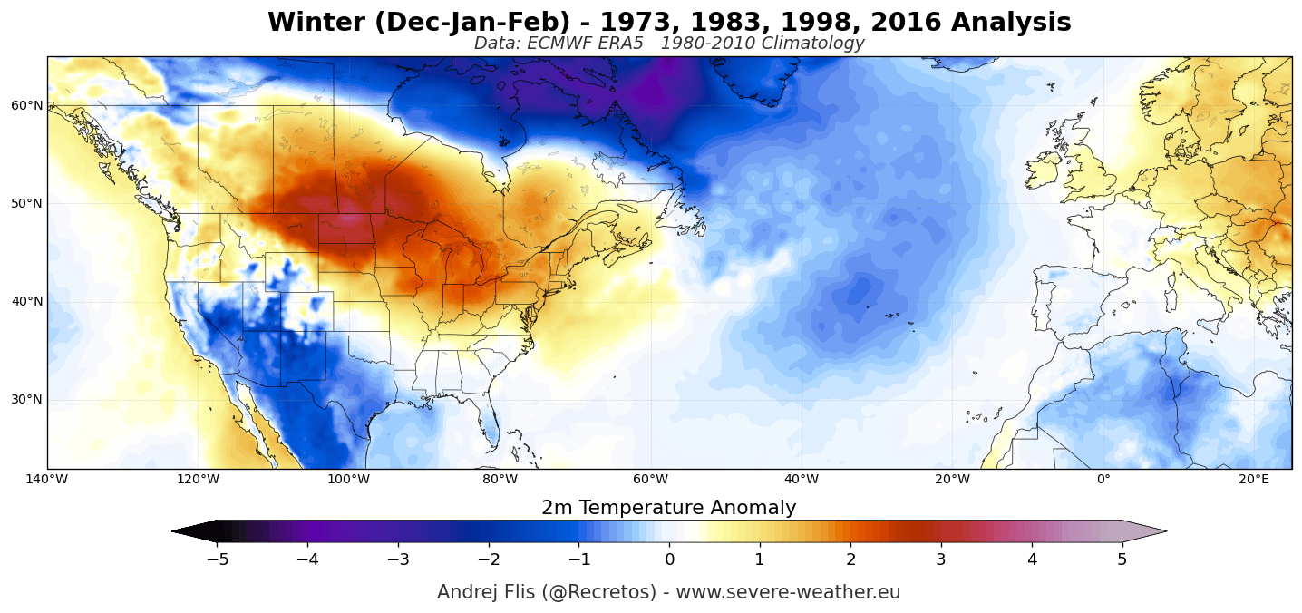
- The Snow and Temperature Divide: The northern tier of the U.S. and southern Canada are slated for a predominantly mild, lower-snowfall winter. Conversely, the southern half, central plains, and eastern regions face an intensifying trend toward below-normal temperatures, heavy precipitation, and significantly elevated snowfall potential.
- The Polar Vortex Wildcard: Stratospheric monitoring reveals a notable weakening of westerly winds in late December and January, opening the door to potential Sudden Stratospheric Warming (SSW) events and severe mid-to-late winter cold-air outbreaks.
Chronology: From Spring Surge to Mid-Winter Amplification
The trajectory of the 2026/2027 winter has been marked by rapid development and successive forecast shifts:
- Early Spring to Summer 2026: Equatorial sea surface temperatures began a rapid upward climb, outperforming the foundational growth rates of previous Super El Niño events on record.
- October 2026 Model Runs: The latest ECMWF seasonal updates revealed a significant trend evolution. Forecasters noted an intensification of the U.S. low-pressure anomaly and Canadian high-pressure blocking, resulting in a notably colder, snowier outlook for the southern and eastern United States compared to previous autumn outputs.
- December 2026 (Projected Onset): The winter season initiates with mild conditions across Canada and the northern U.S. under high pressure, while an active southern jet begins dumping moisture and rain across the Gulf Coast and Southeast.
- January 2027 (Mid-Winter Disruption): Stratospheric westerly winds decelerate significantly below long-term averages. The pattern amplifies, pulling colder air into the south-central U.S. while California and the Southwest experience peak wet-season precipitation.
- February to March 2027 (Backloaded Outbreaks): Consensus among secondary global models—including Canada’s CanSIPS and NOAA’s CFSv2—points toward a pronounced high-pressure block over Canada driving cold anomalies deep into the central, southern, and eastern United States as the pattern peaks before relaxing into early spring.
Supporting Data: Lessons from Past Super El Niños
To contextualize what a record-setting Super El Niño can deliver, meteorologists have re-examined historical high-water marks of severe winter weather across North America:
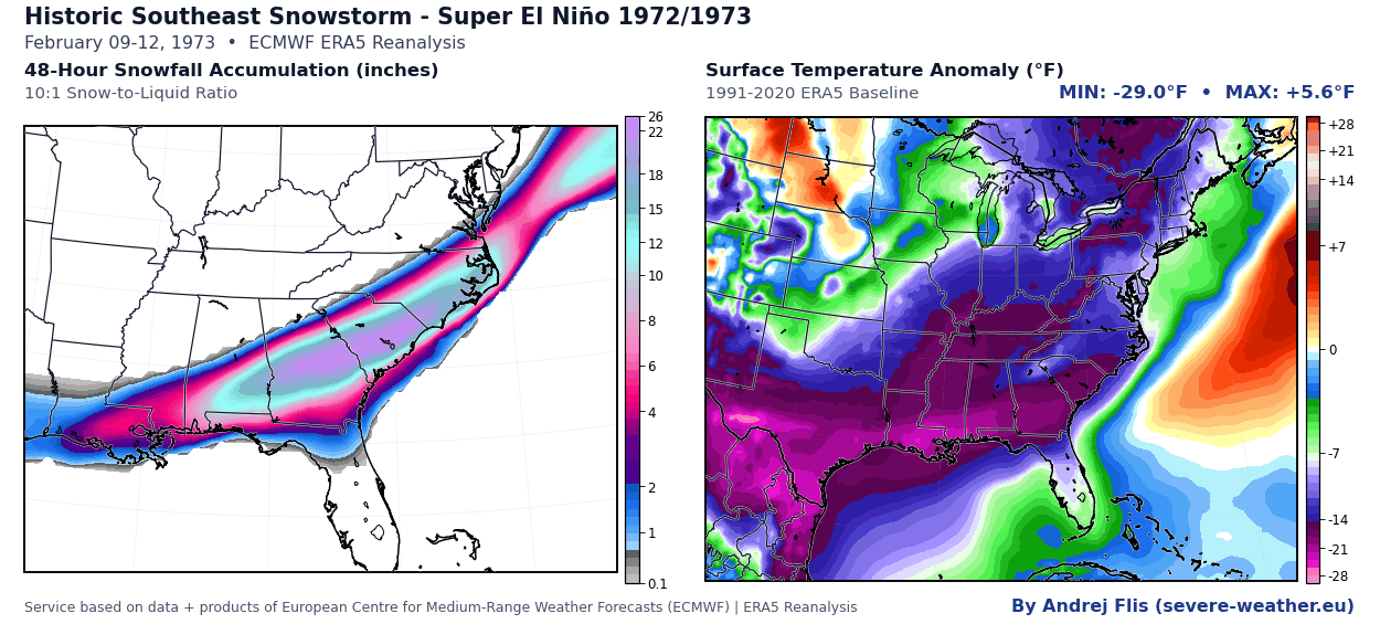
- The Great Southeastern Snowstorm (1972/1973): A strengthening Gulf low pressure system dropped up to 24 inches of snow in South Carolina and 16.5 inches in Georgia, with accumulations reaching as far south as Tallahassee, Florida, paralyzing the region for days.
- The Megalopolitan Blizzard (1982/1983): A ferocious nor’easter battered the I-95 corridor with snowfall rates of 2 to 5 inches per hour. Baltimore and Philadelphia recorded over 22 and 21 inches respectively, setting all-time 24-hour snowfall records.
- The Great Ice Storm (1997/1998): A crippling ice accumulation glazed northern New York, Vermont, New Hampshire, and Maine—where 80% of the population lost power, some for over three weeks—alongside catastrophic utility failures in Ontario and Quebec.
- The Christmas Weekend Blizzard & Historic Nor’easter (2015/2016): The last major Super El Niño spawned a 3-foot snow disaster across the Southern Plains in late December, followed immediately in January 2016 by a Category 4 nor’easter that dumped over 27 inches in Central Park and 29 inches in Baltimore, impacting more than 100 million Americans.
Official Responses and Expert Outlooks
Global meteorological authorities are closely monitoring the cascading atmospheric effects of the Pacific anomaly. The World Meteorological Organization has issued explicit warnings regarding the heightened risks of extreme weather events worldwide as the peak approaches in December.
Domestically, forecasters emphasize that while seasonal outlooks evaluate multi-month tendencies rather than isolated storms, the convergence of strong equatorial forcing and stratospheric instability creates a high-risk environment.
"When you pair a record-strong El Niño with a high-probability mid-winter Polar Vortex disruption, you create a classic recipe for a backloaded winter," notes senior long-range meteorology assessments. "The jet stream positioning guarantees an active storm track, and whenever that moisture taps into cold air injections from the north, severe winter weather outcomes escalate rapidly."
Implications: Regional Breakdown and Sector Impacts
The implications of the Winter 2026/2027 forecast vary drastically by geography and industry:
The United States and Canada
- The North: Milder-than-average temperatures will dominate the Pacific Northwest, upper Midwest, and southern Canada. Snow enthusiasts in these regions may experience a lean season with below-normal snowpacks.
- The South and East: A stormy, unsettled season is guaranteed by the southern jet stream. Recent forecast adjustments show an increased risk of heavy snow events extending from the Central Plains and Ohio Valley into the Southern Appalachians and interior Mid-Atlantic.
- The Western Mountains & Ski Industry: While lower elevations may struggle, high-elevation resorts in the Sierra Nevada of California, the Great Basin, Utah, the Southern Rockies, and Arizona/New Mexico are highlighted for robust above-normal snowfall potential.
Europe
Continental Europe is expected to remain largely under the influence of a mild, wet westerly and southwesterly Atlantic flow. Seasonal temperatures will average above normal across most countries, pointing toward a low-snow winter for lower-elevation areas. However, northern European sectors and high-altitude alpine regions (above 1,800 to 2,000 meters) retain favorable prospects for heavy snowfall when individual low-pressure systems manage to pull down northerly air masses.
Emergency Preparedness and Infrastructure
Municipalities along the active southern and eastern storm corridors are advised to review snow-removal logistics, salt supplies, and emergency response frameworks. Given the historical precedent of sudden, high-impact blizzards and ice storms during Super El Niño winters, infrastructure resilience will face severe tests should the projected mid-winter pattern amplification materialize.
