

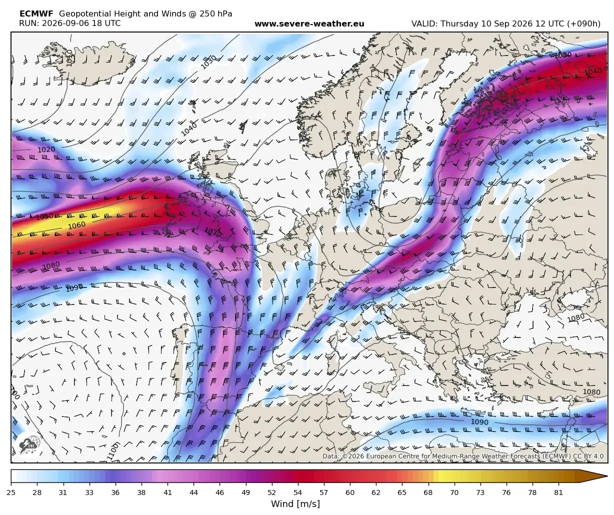
EUROPE — A dramatic and abrupt atmospheric shift is underway across the European continent, bringing a definitive, violent end to the prolonged early-September Heat Dome that has gripped the region for weeks. Driven by a powerful upper-level trough emerging from the North Atlantic, a potent surface cold front is plowing across Western and Central Europe.
The collision of this incoming polar-origin air mass with the entrenched, record-warm, and moisture-laden air sitting over the continent has created a volatile meteorological powder keg. Meteorologists are tracking a widespread severe weather outbreak stretching from the towering peaks of the Alps down into the Western Balkans, accompanied by a staggering thermal collapse that will introduce a crisp, autumn-like reality—and even the season’s first significant alpine snowfall—in less than 24 hours.

Main Facts: A Violent Transition from Summer to Autumn
The transition, which began taking shape midweek, marks a textbook "summer-killer" weather pattern. For much of late August and early September, a formidable high-pressure ridge maintained unseasonably high temperatures, with daytime highs soaring between 35°C and 40°C across vast swaths of the continent.
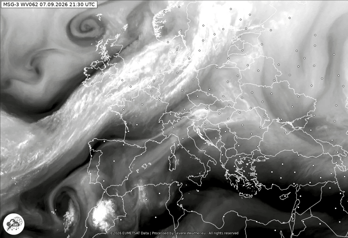
However, the rapid eastward progression of a deep upper-level wave is dismantling this ridge. As the cold front sweeps across the landscape, it is interacting with extreme atmospheric instability fueled by a historic marine heatwave across the Mediterranean Sea.
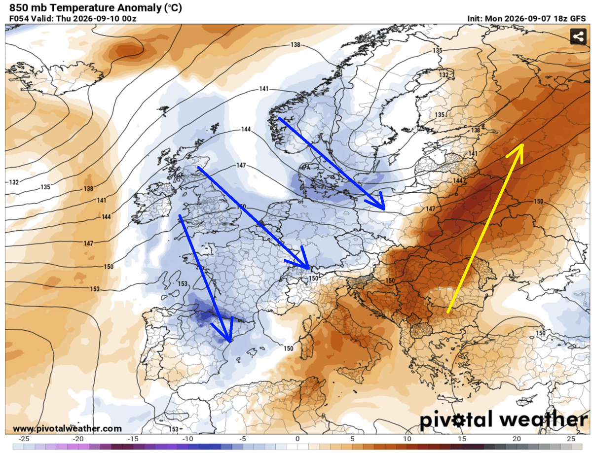
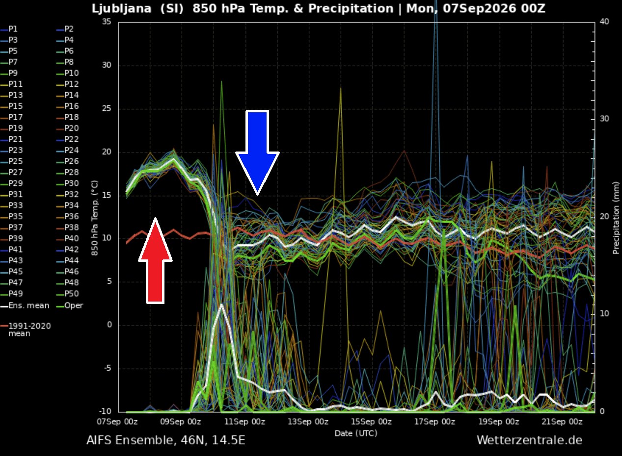
- The Thermal Drop: Temperatures at the 850 mbar level—sitting roughly 10 degrees above long-term seasonal normals—are plunging by 15°C to 20°C in less than 24 hours.
- The Hazards: The clash of air masses is producing a volatile multi-day severe weather outbreak characterized by large to giant hail, destructive straight-line winds, torrential downpours capable of flash flooding, and a localized threat of tornadoes.
- The Geographic Scope: Countries most immediately at risk include Eastern France, Switzerland, the Balearic Islands, Northern Italy, Austria, Slovenia, and Croatia, with impacts cascading eastward into the Western Balkans by Thursday.
- Early Alpine Snow: Behind the front, cold continental winds will plummet snow levels in high-mountain passes, delivering the first heavy snowfall to the higher elevations of the Alps.
Chronology of the Event: From Ridge Breakdown to Frontal Assault
Monday Night to Tuesday: The Catalyst in the Atlantic
The meteorological dominoes began to fall late Monday night as a deep low-pressure system anchored over Scandinavia, coupled with a trailing extension toward the Azores, guided an active upper-level trough into Western Europe. Weather models flagged the breakdown of the high-amplitude ridge, setting the stage for the dramatic thermal contrast. While the core of the extreme heat was swept ahead into Eastern Europe and western Russia, western and central regions braced for the impending shockwave.
Wednesday: The Front Enters the Alpine Region and Western Mediterranean
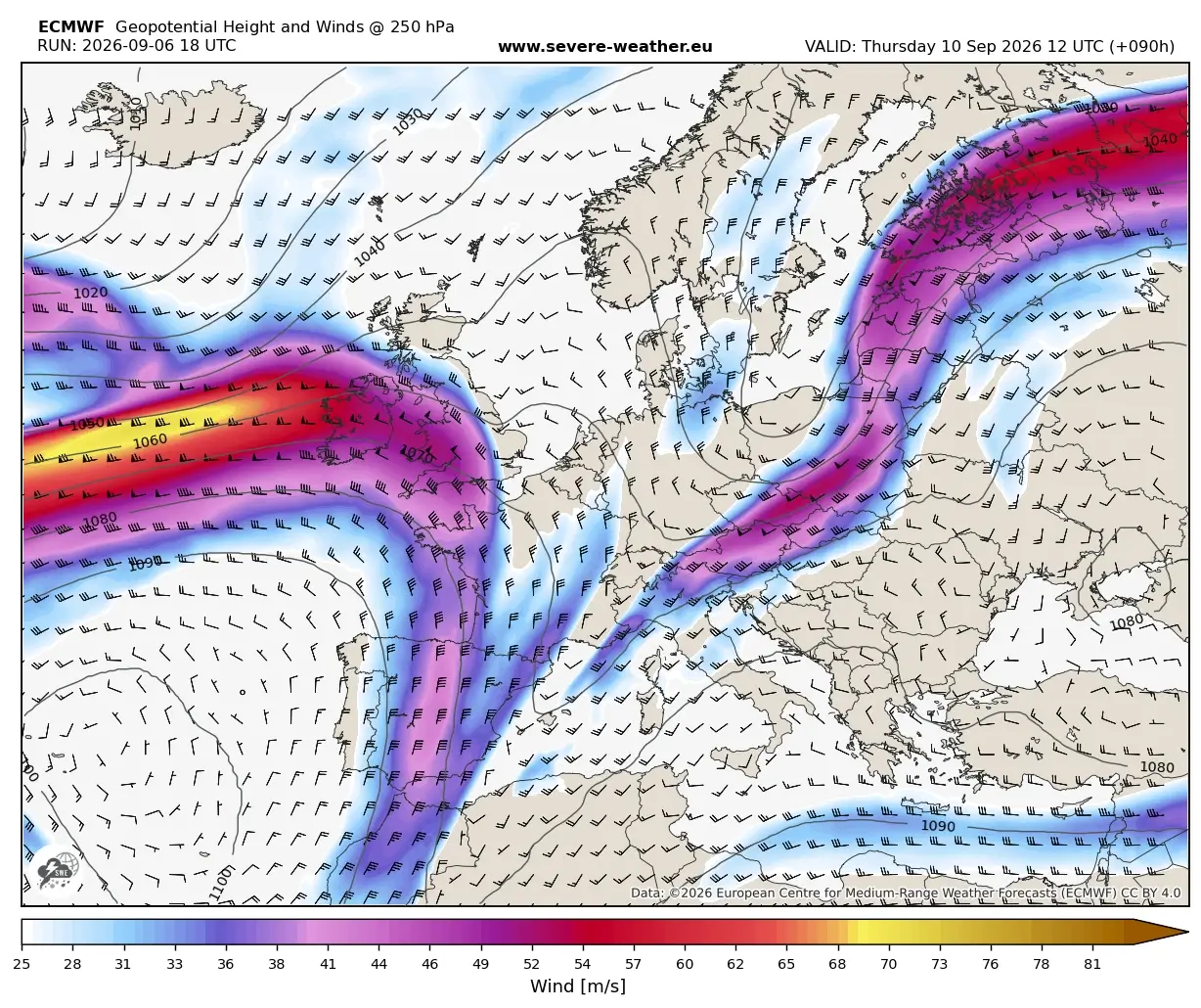
By Wednesday, the high-pressure ridge completely collapsed under intense upper-level forcing. As the cold front pressed into Eastern France, Switzerland, and Northern Italy, it encountered an unusually warm Mediterranean. Jet stream winds intensified sharply over the central continent, establishing robust vertical wind shear.
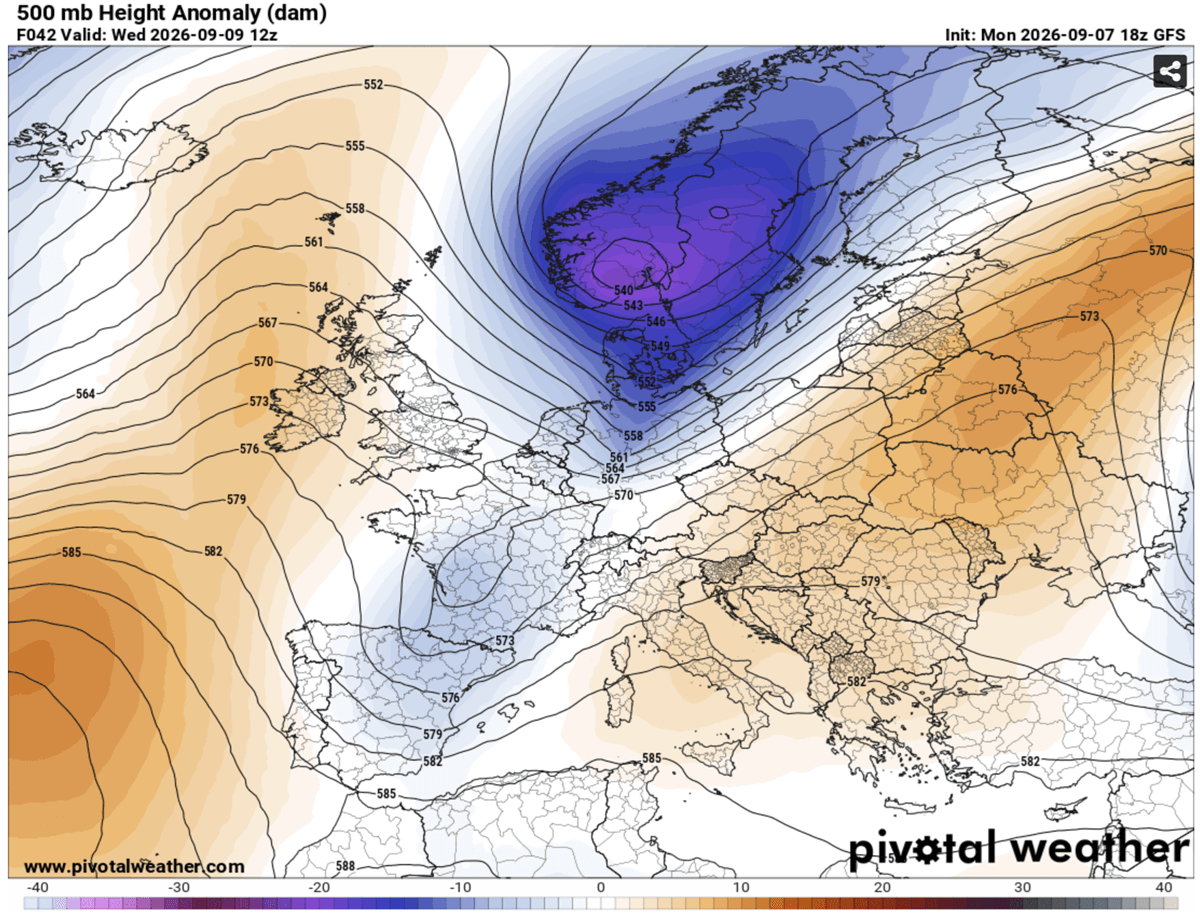
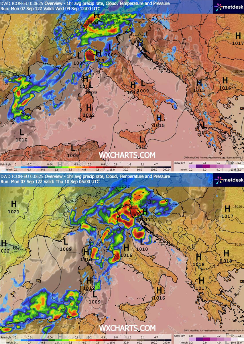
Concurrently, a secondary low-pressure wave cut off into the Northern Mediterranean, tracking across Italy toward the Western Balkans. This dynamic allowed the frontal system to slow down and intensify, maximizing its destructive potential. By midday Wednesday, violent supercells and multicell storm clusters erupted over the Balearic Islands before marching aggressively toward Northern Italy and the North Adriatic Sea by evening.
Thursday and Beyond: The Balkan Outbreak and Sustained Rainfall
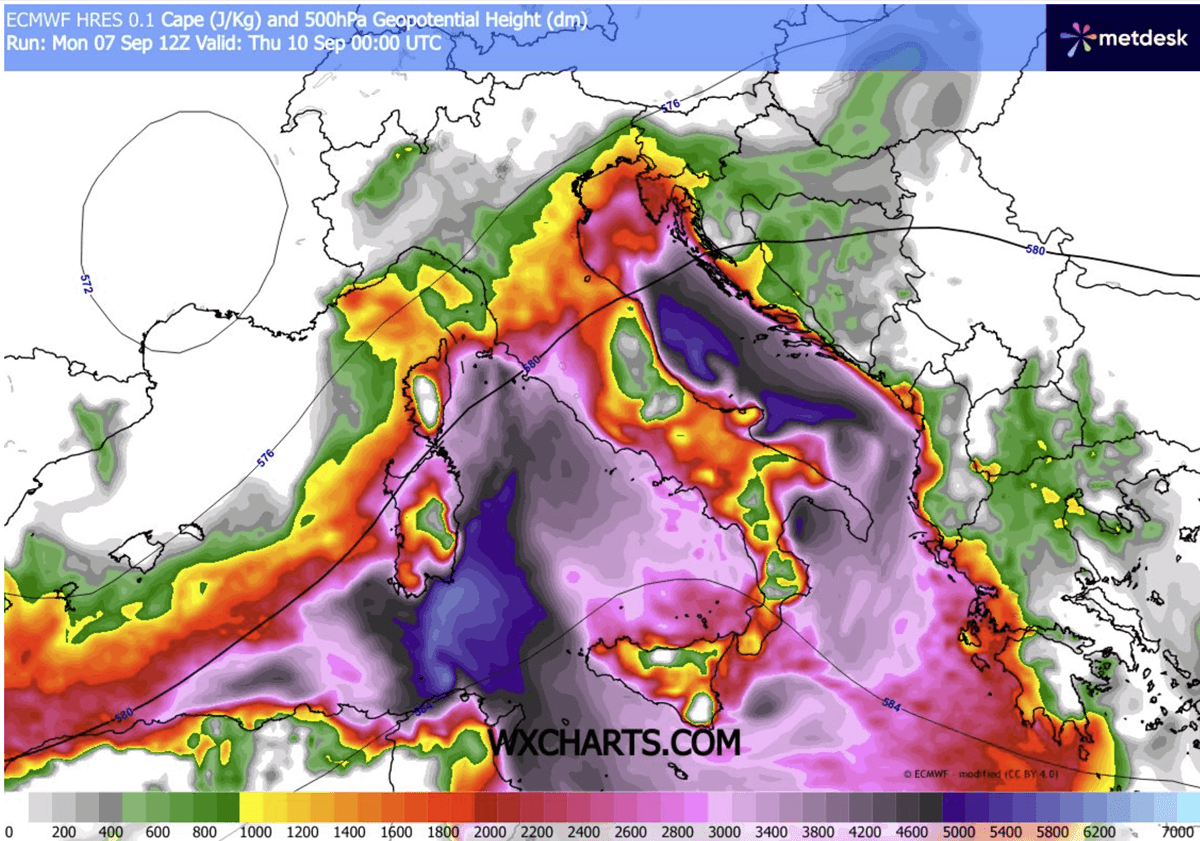
The severe weather threat pivots eastward on Thursday, targeting the Western Balkans, Central Italy, and the Adriatic basin. High moisture levels, extreme instability—with Convective Available Potential Energy (CAPE) values surging past 3000–4000 J/kg—and slow-moving storm cells are creating a dangerous "training" effect. This phenomenon, where multiple storms repeatedly pass over the same saturated regions, is expected to dump localized rainfall totals of 150 to 200 mm over a 48-hour period, particularly along Liguria Bay, the North Adriatic, and the Tuscan coast.
Supporting Data and Synoptic Analysis
The severity of this pattern shift is vividly illustrated by meteorological diagnostics, including meteograms and atmospheric sounding models.
Thermal Collapse and Instability
In cities such as Ljubljana, Slovenia, baseline temperatures at the 850 mbar level plummeted from near 18°C–20°C down toward seasonal norms in a matter of hours. This vertical cooling profile destabilized the lower troposphere.
[Incoming Polar Trough] ---> [Colliding with Mediterranean Heat/Moisture]
                                      |
       +------------------------------+------------------------------+
       |                                                             |
[Severe Convection]                                        [Thermal Plunge]
- Giant Hail & Damaging Winds                              - 15°C to 20°C Drop
- Torrential Rains / Flash Floods                          - First Alpine Snow
- Localized Tornado Threat                                 - Autumn-Like Airmass
Because the preceding marine heatwave over the Mediterranean has not been easily flushed out, sea-surface temperatures remain abnormally high. This persistence provides an abundant reservoir of moisture and high dewpoints, fueling extreme CAPE values. When combined with strong mid-level jet stream winds, the environment yields the classic kinematic signatures required for organized severe weather, including rotating supercells capable of producing destructive wind gusts and large hail.
Precipitation and Hydrological Risks
Hydrologists are closely monitoring rainfall projections. The combination of steep lapse rates, forced topographic lift along the Alps, and slow storm motions means that flash flooding remains the primary hazard for urban and low-lying coastal areas alike. Rivers and streams originating in the southern Alps and the Dinaric Alps face rapid, hazardous rises.
Official Responses and Civil Protection Advisories
National meteorological and civil protection agencies across Western, Central, and Southern Europe have issued high-level weather alerts in anticipation of the onslaught.
- Italy: Civil Protection authorities issued orange and red alerts for severe thunderstorms, high winds, and potential flash flooding across northern regions, particularly Lombardy, Veneto, and Liguria. Residents and campers near waterways have been advised to exercise extreme caution.
- Switzerland and Austria: Mountain authorities have issued warnings for hikers and climbers regarding sudden blizzard conditions, heavy alpine snowfall, and sharply dropping wind chills above 2,000 meters. Road maintenance crews are on standby to clear high-mountain passes that could be temporarily closed by early snow accumulations.
- Slovenia and Croatia: Environmental agencies have alerted populations along the Adriatic coastline to prepare for potential coastal flooding driven by strong onshore squalls and torrential downpours. Municipalities have cleared storm drains to mitigate urban flooding risks.
Implications: A Turning Point for the European Climate Season
The collapse of the early-September Heat Dome carries broad implications for both ecosystems and human infrastructure.
Agricultural and Hydrological Relief
While the severe weather brings immediate risks of property damage and localized flooding, the broader agricultural and ecological impacts are viewed with cautious optimism. Weeks of relentless drought and extreme heat had stressed crops, lowered river levels across Central Europe, and exacerbated wildfire risks. The widespread rainfall—though intense in localized bursts—will help replenish depleted soil moisture levels and cool overheated water bodies.
Seasonal Transition
Climatologically, this system serves as the definitive nail in the coffin for summer 2026. Long-term atmospheric models indicate that the jet stream will remain active and dynamic well into mid-September, preventing any immediate return of heat-dome conditions. Instead, a succession of Atlantic and polar disturbances will establish a classic, brisk autumn regime across the continent.
As Europe turns the page on one of its more oppressive late-season heat events, authorities urge the public to heed local warnings, secure outdoor property, and prepare for winterized driving conditions in mountain transit corridors over the weekend.
