

Main Facts
Meteorological agencies and global climate models are sounding an urgent alarm across the meteorological community: a powerful, potentially record-shattering Super El Niño is rapidly unfurling across the tropical Pacific Ocean. Oceanographic analyses and long-range forecast data indicate that this high-intensity El Niño event is tracking toward an unprecedented peak by late fall and early winter. Driven by anomalous subsurface warming and powerful oceanic Kelvin waves, the event is already exerting an aggressive "atmospheric bridge" effect—a global-scale teleconnection that fundamentally alters pressure systems, wind currents, and temperature anomalies from North America to Europe.
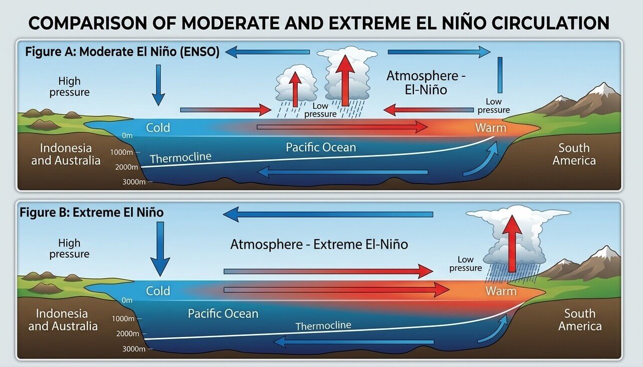
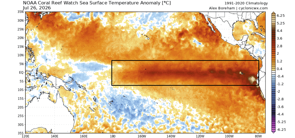
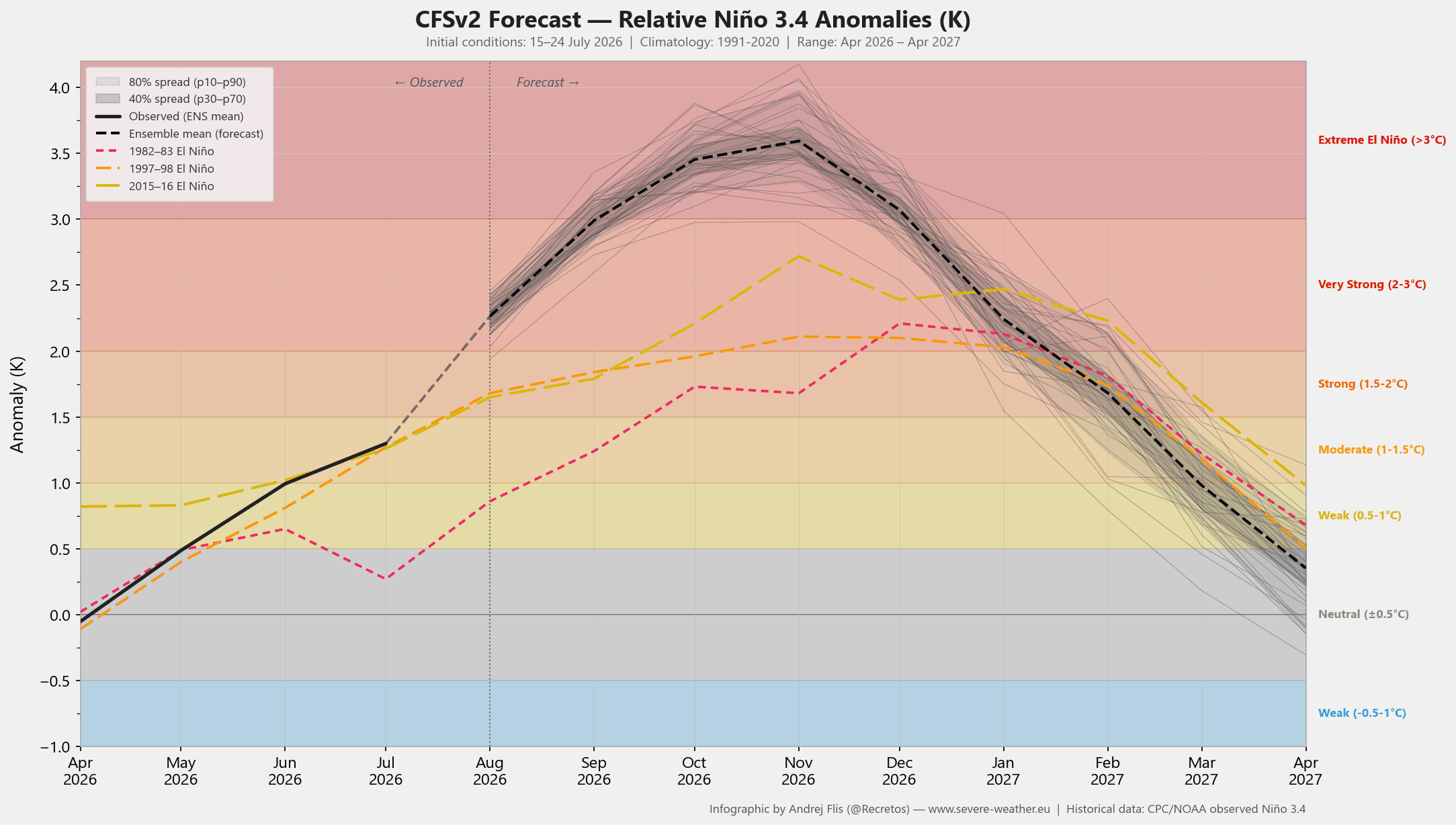
Unlike standard or moderate El Niño phases, which typically induce mild, predictable seasonal variations, a Super El Niño acts as a heavy-handed meteorological engine. Current NOAA Climate Prediction Center (CPC) outlooks and NCEP CFSv2 model runs demonstrate that sea surface temperature (SST) anomalies in the central and eastern Pacific are rocketing past the traditional El Niño threshold of +2°C, with peak anomalies projected to approach or exceed +3°C to +5°C above normal. This immense thermal energy is locking a stationary "atmospheric standing wave" over the Pacific basin, creating a feedback loop that forces the subtropical jet stream to aggressively buckle, setting the stage for extreme seasonal volatility throughout late summer, autumn, and the heart of the 2026–2027 winter.
Chronology: From Subsurface Kelvin Waves to Global Forcing
To understand how this meteorological juggernaut evolved, climatologists trace its lineage back to deep oceanic shifts that occurred earlier in the year.
Spring to Early Summer 2026: The Subsurface Buildup
The foundation of the current Super El Niño was laid by powerful westerly wind bursts sweeping across the western equatorial Pacific. These winds triggered massive subsurface warm-water pools known as Kelvin waves. Propagating eastward beneath the ocean surface over several months, these thermal anomalies ultimately breached the surface in the central and eastern tropical Pacific, creating the massive positive sea surface temperature anomalies observed today.
July 2026: Immediate Atmospheric Fingerprints
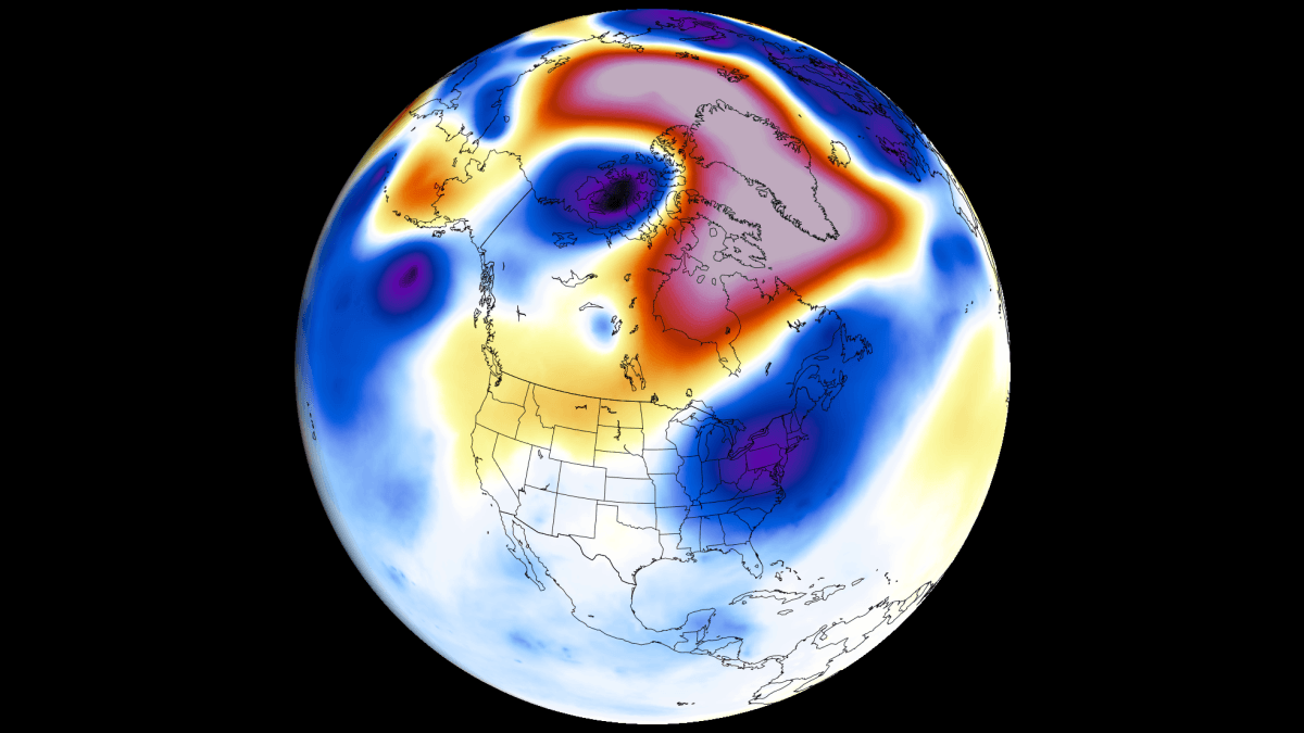
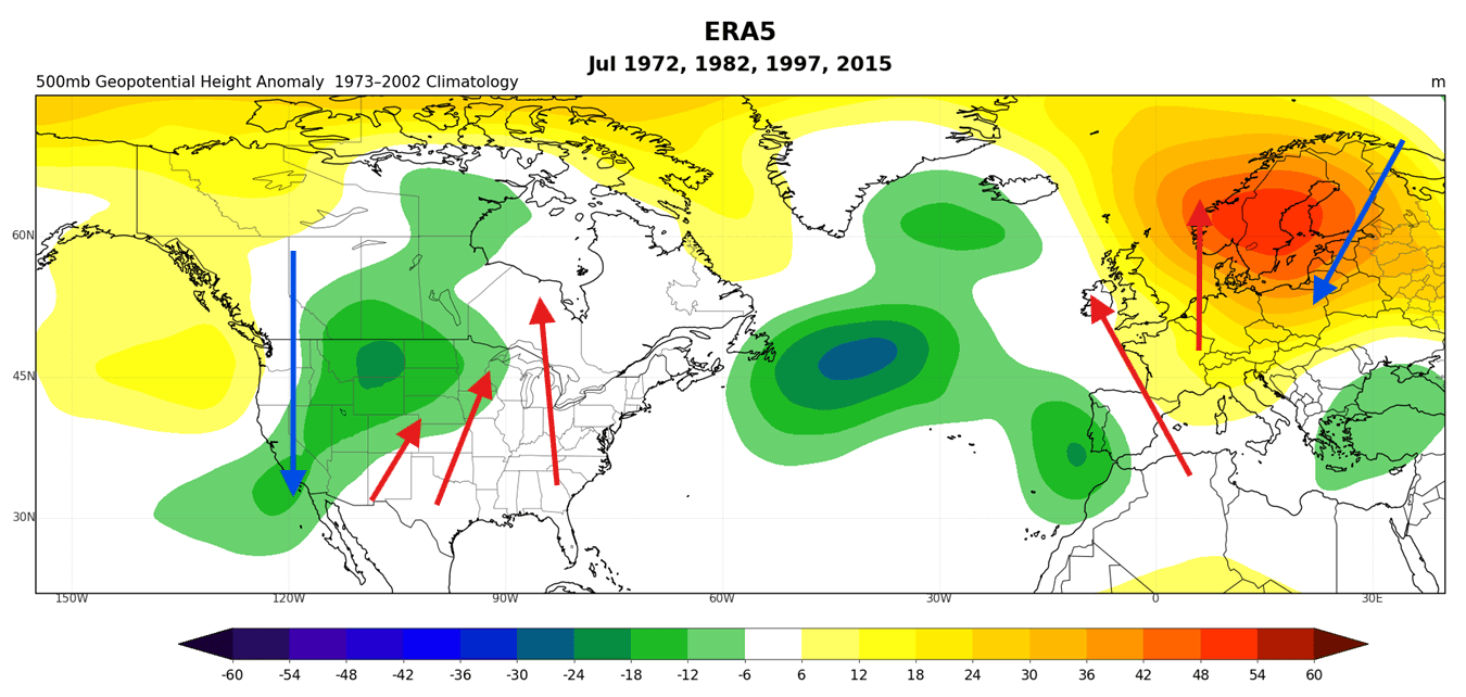
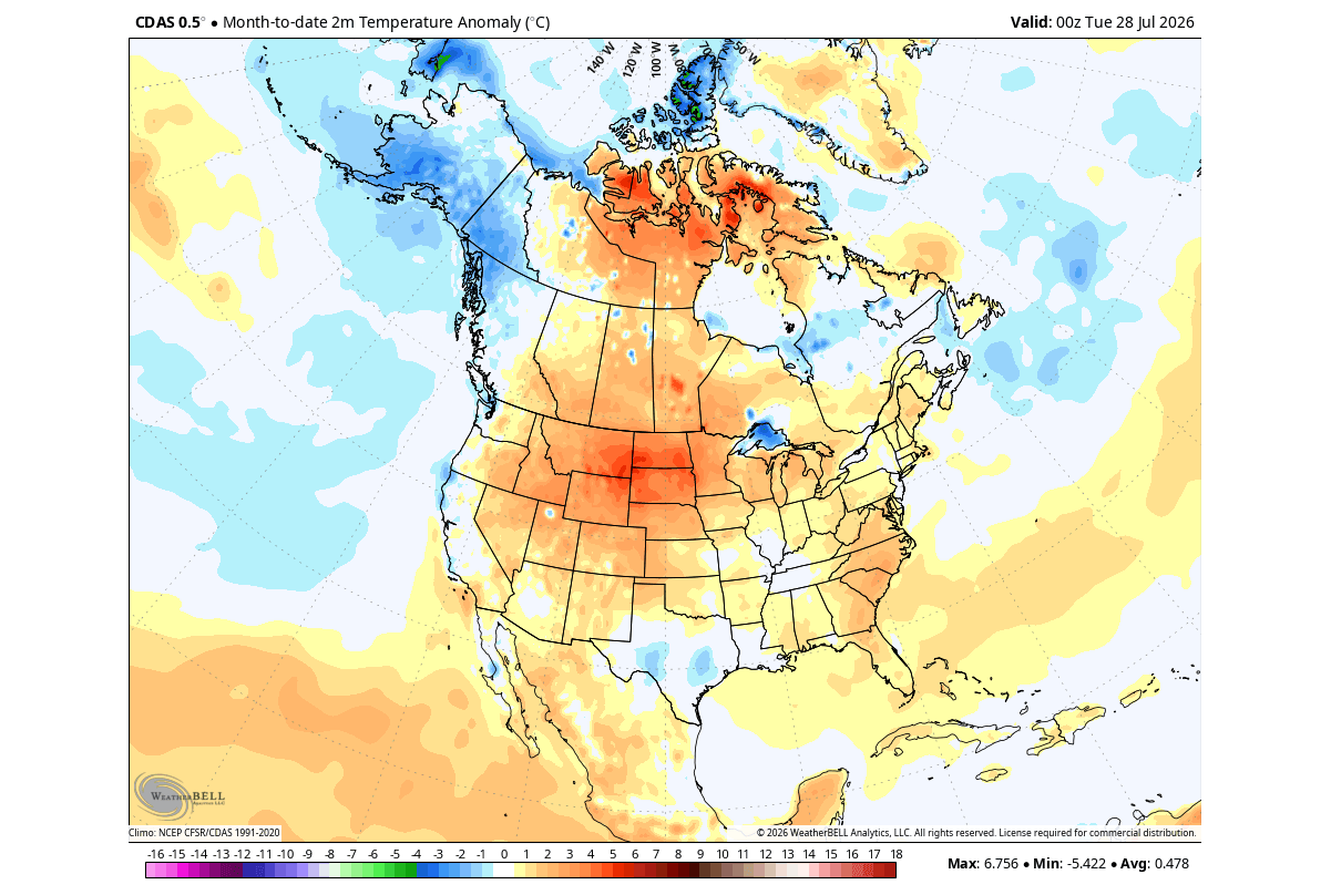
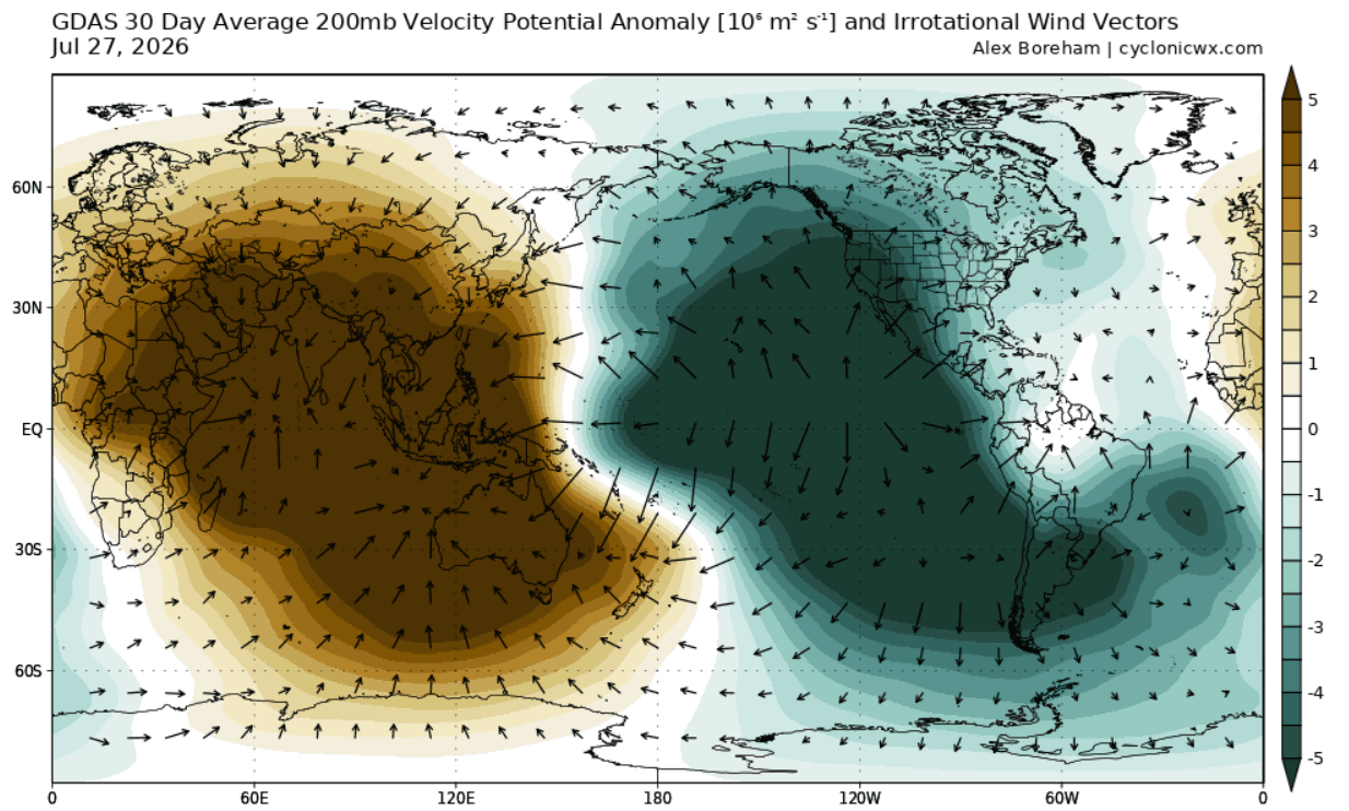
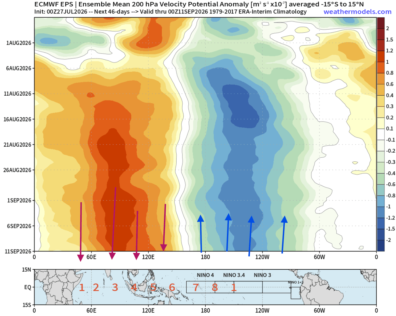
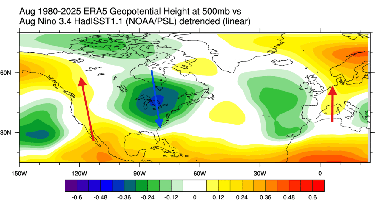
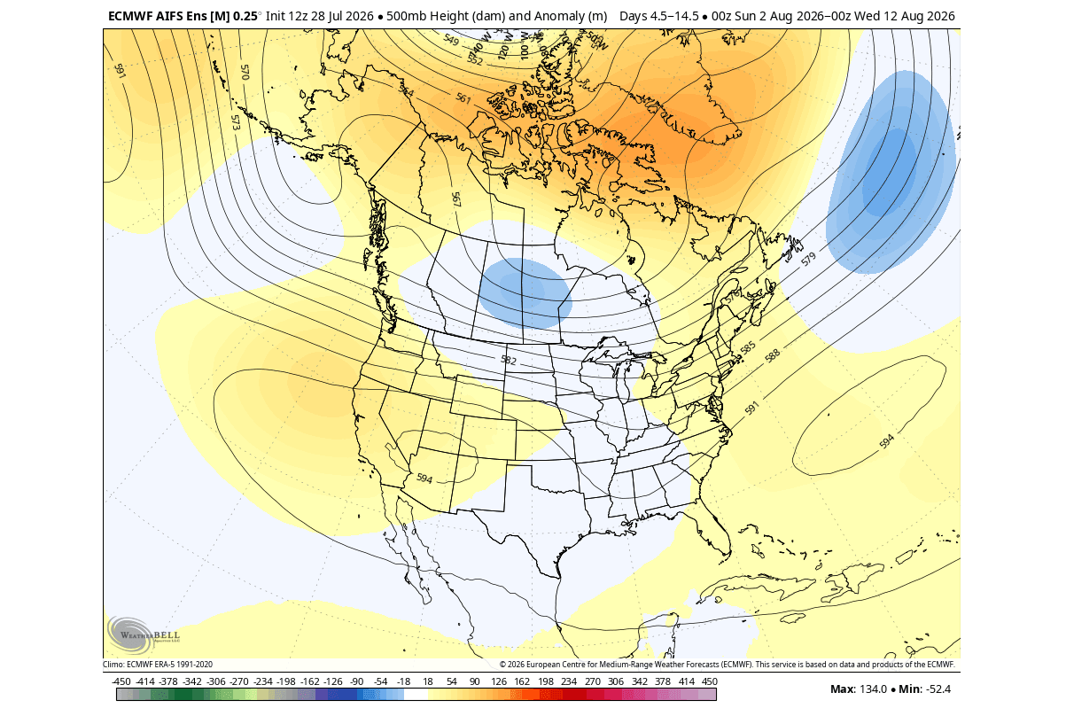
As July drew to a close, atmospheric pressure and temperature patterns across North America began to mirror historical analogs of past Super El Niño years with eerie precision. ECMWF reanalysis data revealed a pronounced western shift in the primary North American low-pressure trough. This shift cultivated a robust high-pressure ridge across the central and eastern United States and Canada, sparking early-season heat anomalies while maintaining cooler, northwesterly maritime flows along the West Coast. Simultaneously, GDAS velocity potential metrics confirmed a drastically modified Walker circulation cell, marked by intense rising air motion over the eastern Pacific and robust sinking motion over the Indian Ocean.
August 2026: The Transition to Eastern US Troughing
Entering August, the atmospheric engine shifted gears. While early-month forecasts hinted at mixed regional pressure configurations, extended ensemble predictions highlighted a progressive transition: a low-pressure anomaly digging into the eastern United States and Canada, coupled with a dominant ridge anchored over the west-central continent. This dynamic began dragging normal-to-below-normal temperatures and active rainfall into the Midwest and East Coast by mid-to-late August, validating the textbook progression of an advancing El Niño signal.
Fall and Winter 2026–2027: Peak Amplification
Looking ahead, climate models project an acceleration of this pattern. By autumn, an amplified split-flow jet stream will lock into place, paving the way for a classic, high-impact El Niño winter characterized by suppressed northern cold and active, storm-laden southern tracks.
Supporting Data & Observational Evidence
The confidence behind the 2026–2027 Super El Niño forecast rests upon a mountain of observational data, multi-model consensus, and historical reanalysis:
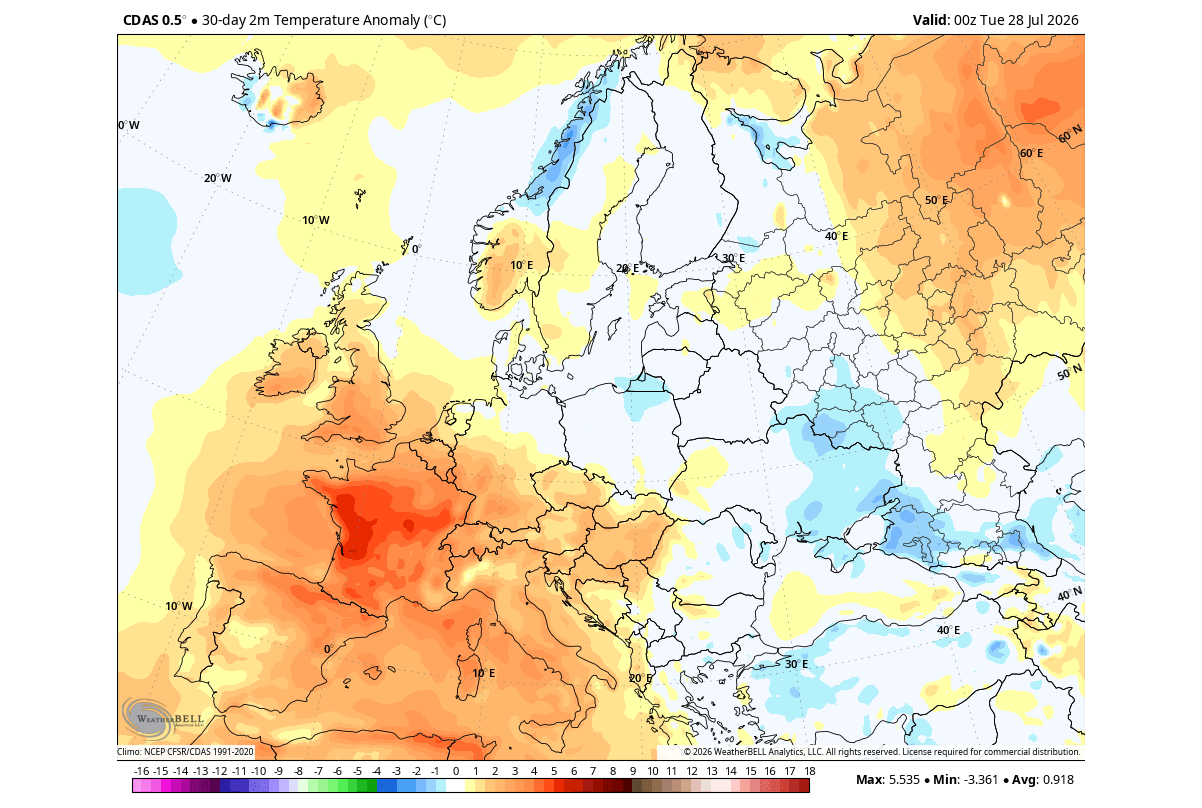
- Sea Surface Temperature (SST) Anomalies: Latest updates from NOAA and ECMWF confirm main ENSO region anomalies exceeding historical developmental curves, outpacing even the parameters of past record-setting events.
- Velocity Potential (200mb): High-altitude wind and divergence analysis clearly demonstrates the displacement of global overturning circulation, proving that the tropical Pacific is effectively driving mid-latitude weather patterns.
- The EP vs. CP Dynamic: Seasonal forecasts from the NMME (North American Multi-Model Ensemble) classify the upcoming event primarily as an Eastern Pacific (EP) El Niño for the October–December window. However, because the raw thermal anomaly exceeds +4°C, its sheer intensity transcends typical structural limitations, forcing an aggressive atmospheric response typically reserved for Central Pacific mega-events.
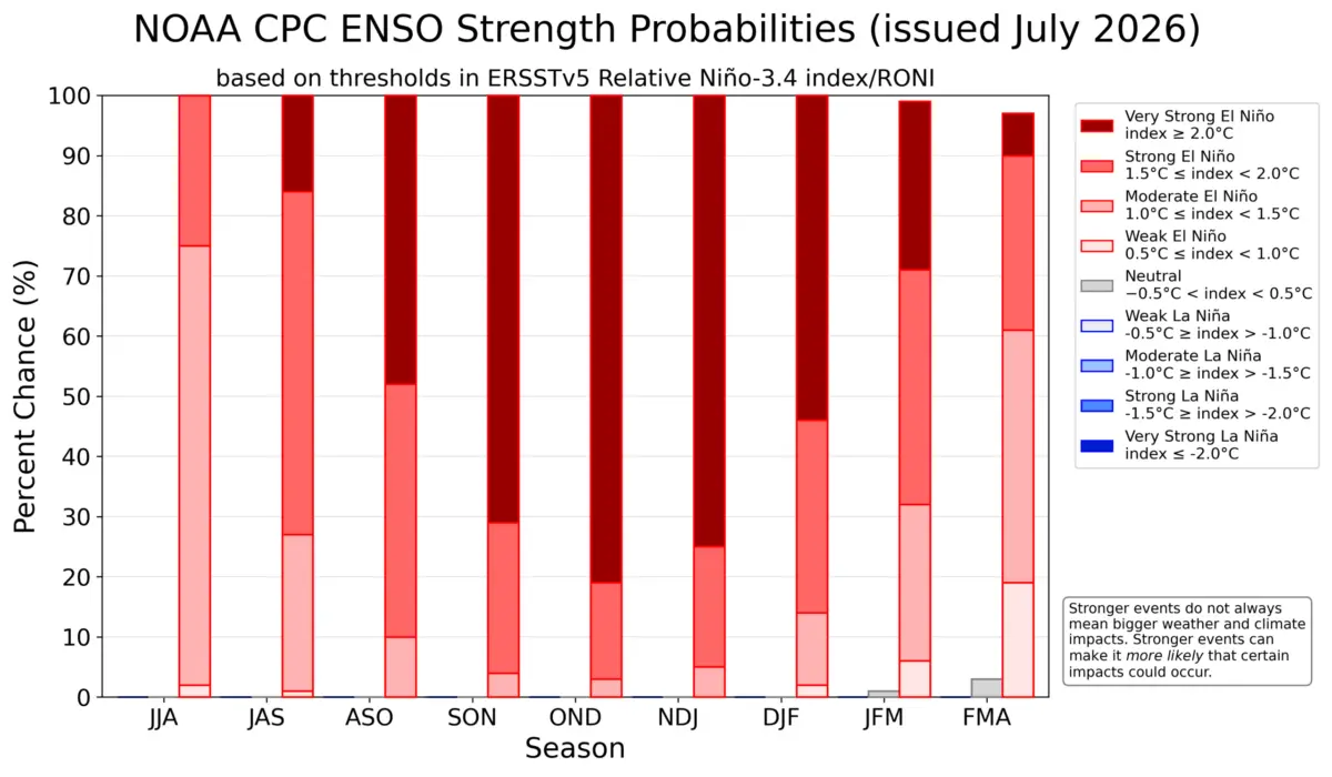
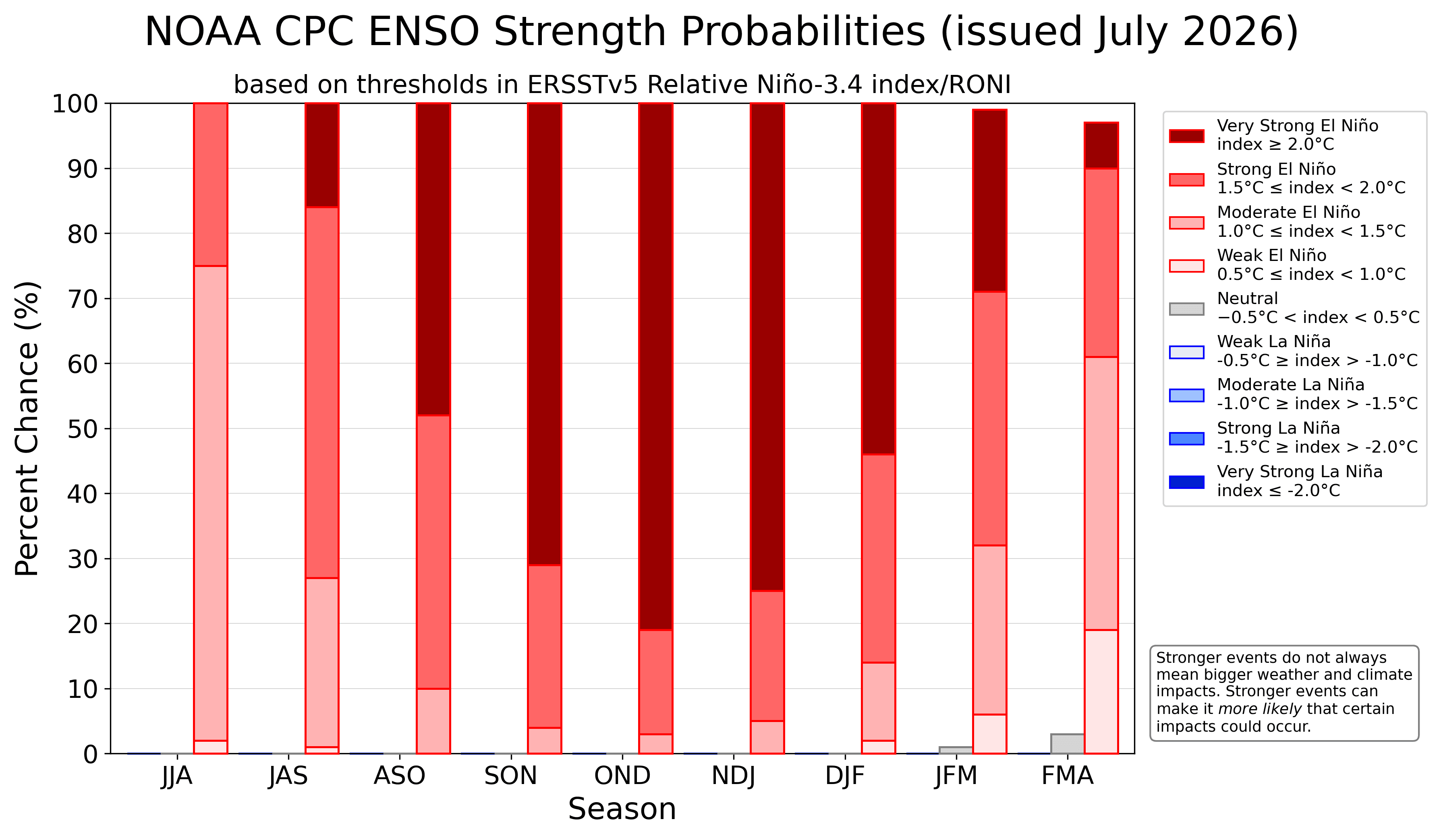
- Ensemble Support: NOAA CPC strength probabilities show virtually zero ensemble support for a weak or moderate outcome; the probability distribution heavily favors a historic, extreme-category El Niño peak spanning late 2026 and early 2027.
Official Responses and Scientific Consensus
Global meteorological authorities—including the National Centers for Environmental Prediction (NCEP), the Climate Prediction Center (CPC), and the European Centre for Medium-Range Weather Forecasts (ECMWF)—are maintaining continuous, high-priority surveillance of the tropical Pacific.
In official briefings, forecasters emphasize that while standard ENSO advisories are routine, the velocity of the current anomaly development is exceptional. Climate scientists note that the system’s unprecedented heating rate creates a temporal mismatch with traditional seasonal indicators. For instance, while European weather patterns typically lag behind direct El Niño forcing due to intervening regional variables (such as North Atlantic oscillations and high-pressure blocking anomalies), the sheer kinetic energy of a Super El Niño inevitably breaches these barriers as it reaches its apex.
Research cited from foundational climatological studies on Hadley and Walker cell mechanics underscores that when ocean anomalies breach the extreme threshold (+3°C and above), upper-level atmospheric bridges become hyper-efficient. This efficiency strips away regional weather buffer zones, binding distant continents into the overarching rhythm of Pacific thermodynamics.
Implications for North America and Europe
The ripple effects of this Super El Niño will radically redefine weather experiences across the Northern Hemisphere over the coming months.
North America (Fall 2026 & Winter 2026–2027)
- Temperature Profiles: A robust high-pressure blocking pattern over Canada will largely suppress deep, sustained Arctic air outbreaks across the Northern Plains, Upper Midwest, and Great Lakes during early winter. Conversely, an expanding footprint of below-normal temperatures is projected to take root across the Southern Plains, Gulf Coast, and eventually the Eastern United States as frequent cold-air intrusions sweep southward in January and February.
- Precipitation and Storm Tracks: The amplified subtropical and Pacific jet streams will act as an atmospheric firehose, driving active, moisture-rich storm tracks across the southern half of the U.S. This points toward heightened winter storm and heavy rainfall potential from the Central and Southern Plains into the interior Mid-Atlantic, while the Pacific Northwest and Upper Midwest lean drier and milder than average.
Europe (Autumn to Winter Transition)
- Pressure and Temperature Trends: Europe’s response remains nuanced. While late summer and early autumn have featured shifting high-pressure anomalies and variable low-pressure zones yielding above-normal warmth and dry spells across central and western regions, the approach of deep winter will see the global atmospheric bridge exert greater control.
- Moisture Dynamics: An active Atlantic low-pressure interface is expected to channel strong westerly and southwesterly marine flows across the continent, driving above-normal autumn and winter precipitation totals across most regions outside of the far north.
As the meteorological community tracks these developments on a weekly basis, the 2026–2027 Super El Niño stands as a stark reminder of the planet’s interconnected ocean-atmosphere system—one capable of shifting global seasonal realities with monumental force.
