

GLOBAL CLIMATE OUTLOOK — Meteorological agencies worldwide are raising alarms as a remarkably powerful "Super El Niño" rapidly takes shape in the tropical Pacific Ocean. Oceanographic analyses and long-range numerical modeling confirm that anomalous warmth is building at an unprecedented pace, setting the stage for an extraordinarily volatile weather pattern.

Traditionally, the meteorological transition from autumn to winter features sluggish, loosely organized seasonal circulation. However, advanced global forecast models indicate that the sheer magnitude of this emerging El Niño is overriding typical seasonal inertia. The atmospheric impacts are locking in early, threatening to reshape weather paradigms across North America, Europe, and the global tropics for the remainder of 2026 and well into early 2027.
1. Main Facts: The Anatomy of a Super El Niño
The El Niño-Southern Oscillation (ENSO) is currently transitioning aggressively into a historically strong warm phase. ENSO governs the multi-year cycle of sea surface temperature fluctuations across the equatorial Pacific Ocean. When these anomalies cross specific temperature thresholds, they trigger a profound ripple effect through global atmospheric circulation known as teleconnections.
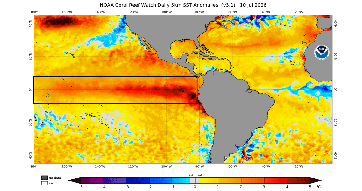
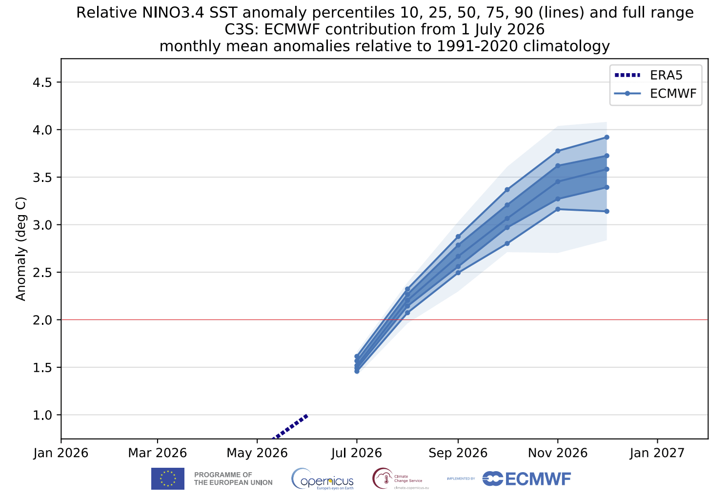
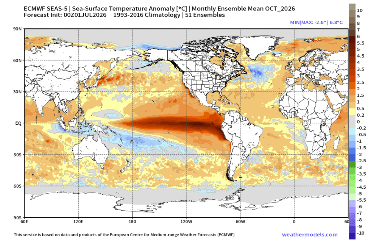
- Defining a Super El Niño: To be classified as a Super El Niño, sustained seasonal sea surface temperature anomalies in the core ENSO regions must exceed +2.0 degrees Celsius above normal. Current ECMWF and NOAA outlooks project peak anomalies soaring past +3.0°C to +4.0°C—and potentially touching +6.0°C in localized indices by late autumn—placing this event in a league of its own.
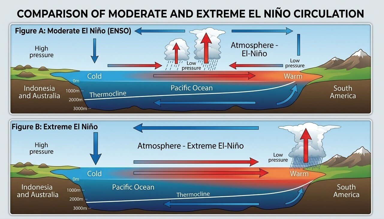
- Early Atmospheric Response: The Walker Circulation—the massive loop of air currents cycling across the tropical Pacific—is already demonstrating severe disruptions. Pressure is dropping sharply across the central and eastern tropical Pacific, while high-pressure regimes build over the western Pacific, channeling massive moisture plumes into the mid-latitudes.
- Geographic Reach: While North America experiences direct, immediate pressure shifts from the Pacific bridge, European weather systems are heavily influenced by downstream modifications, particularly via persistent westerly and southwesterly flow patterns originating over a dynamic Atlantic Ocean.
2. Chronology: From Rapid Oceanic Onset to Winter Amplification
The escalation of this event has stunned meteorologists due to its velocity. The chronology of the 2026–2027 ENSO lifecycle reveals a remarkably accelerated timeline compared to historical benchmarks.
Spring to Early Summer 2026: Rapid Anomaly Surge
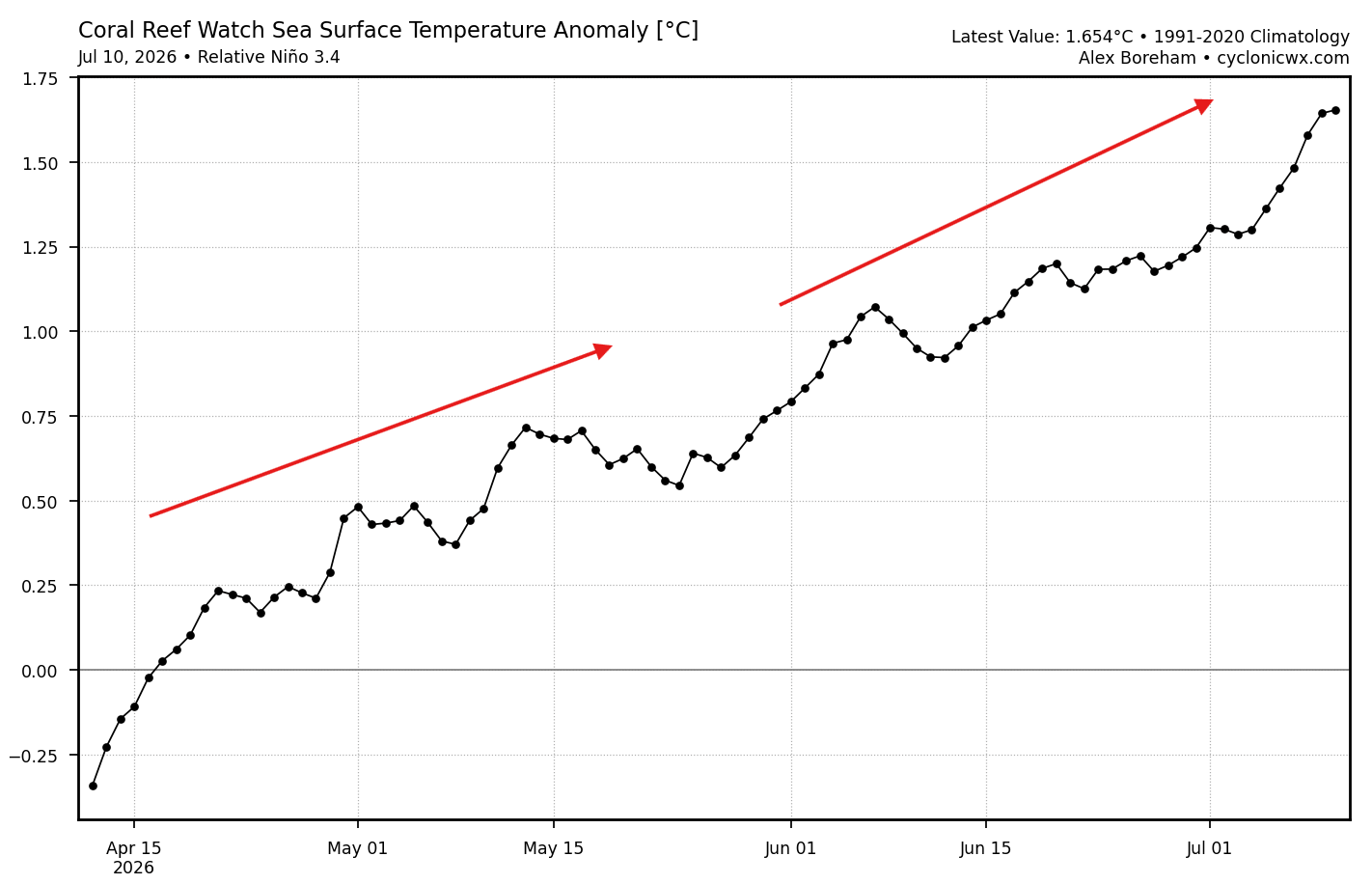
Beginning in the late spring, subsurface ocean temperatures in the equatorial Pacific began pooling rapidly. By early summer, surface anomalies in the eastern ENSO boxes blew past +3.0°C to +4.0°C. This rate of intensification far outpaces standard El Niño developments, prompting top-tier forecasting centers to rule out a moderate event early on.
Meteorological Fall 2026: A Winter-Like Signature Arrives Early
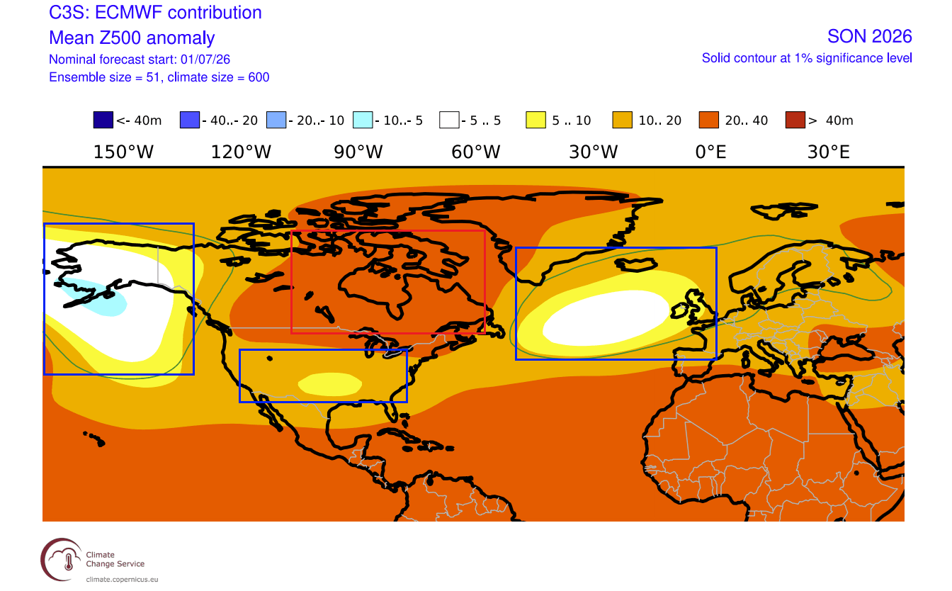
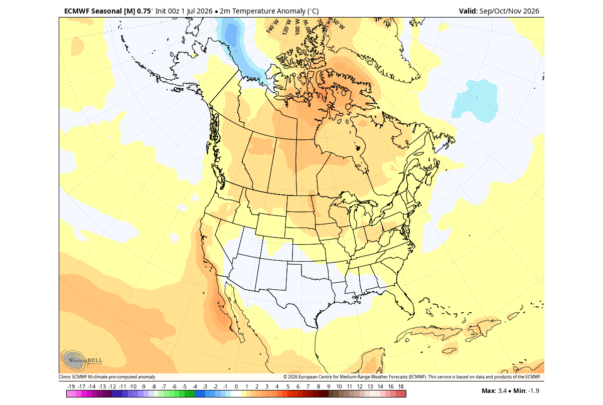
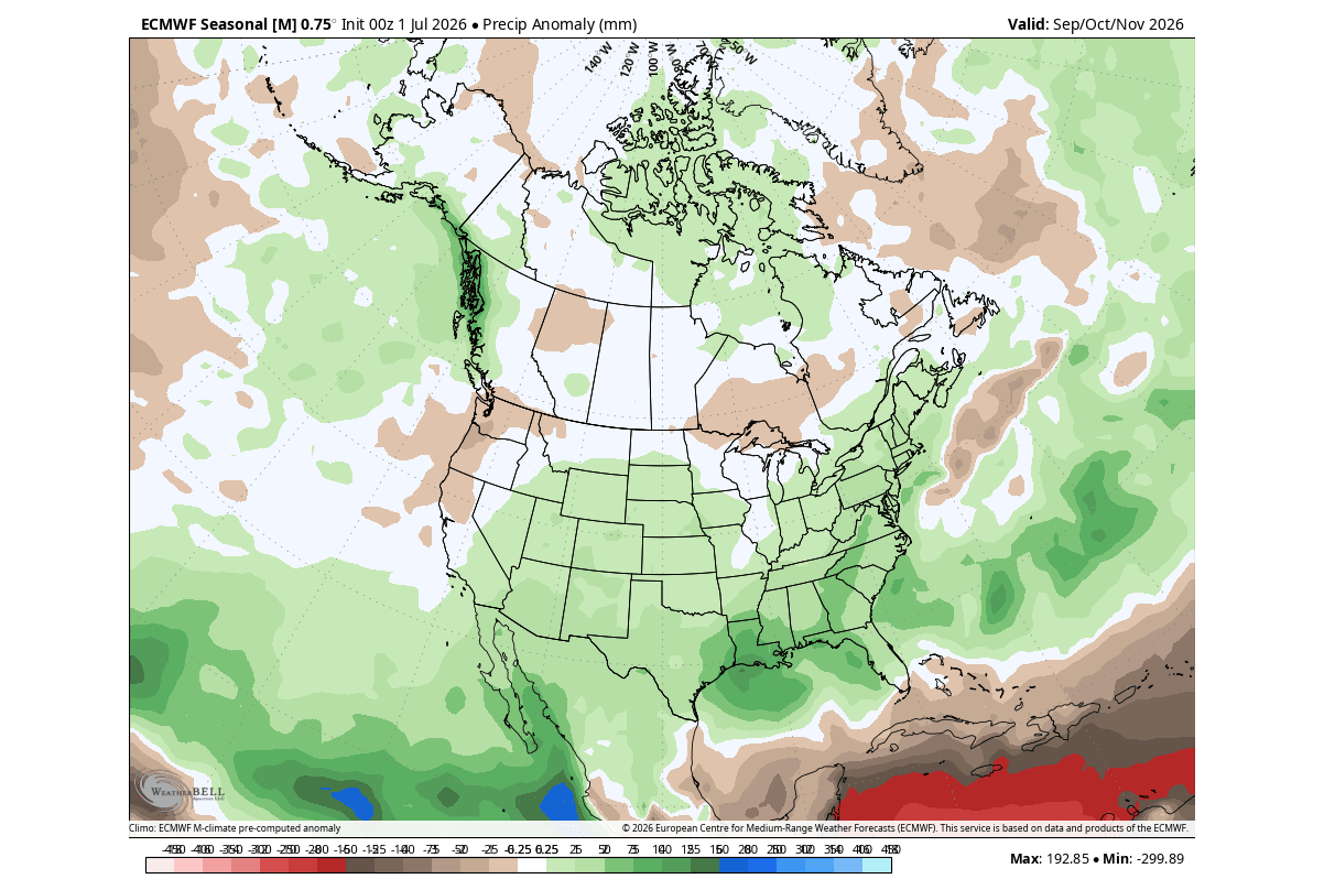
As the Northern Hemisphere steps into meteorological autumn (September–November), seasonal models from both the European Centre for Medium-Range Weather Forecasts (ECMWF) and the North American Multi-Model Ensemble (NMME) show a startling anomaly: pressure patterns typical of a deep, mid-winter El Niño are already locked into place.
- A dominant high-pressure atmospheric ridge is anchoring over Canada.
- A deep low-pressure storm corridor is organizing across the southern United States.
- This is uncharacteristic for autumn, signaling that the global atmospheric engine is running far ahead of schedule.
Late Fall to Mid-Winter 2026/2027: Peak Amplification
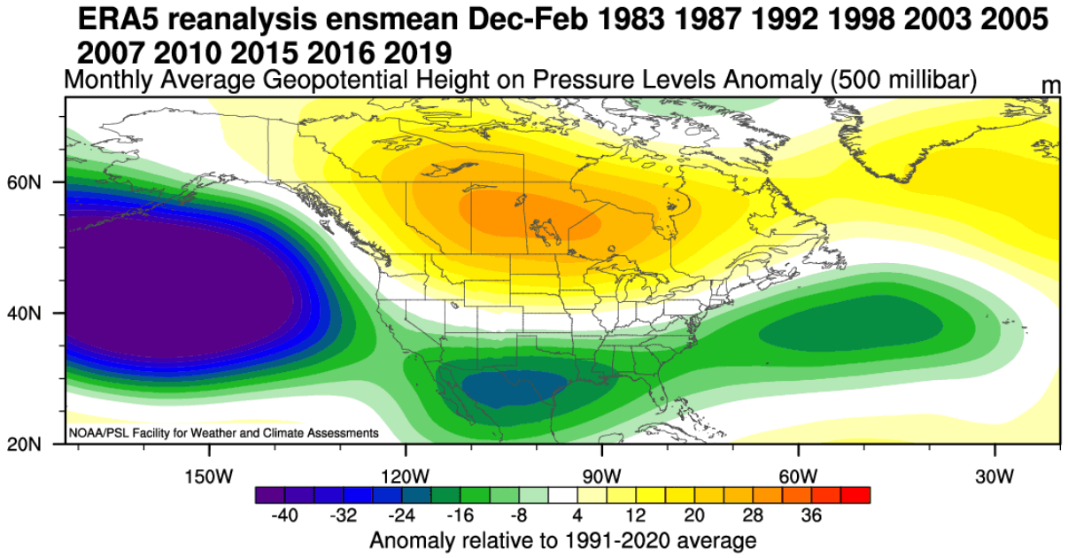
As the calendar flips toward December and January, the static pressure patterns observed in autumn will deepen significantly. The Canadian high-pressure block will act as a massive atmospheric boulder, deflecting the polar jet stream while supercharging the subtropical jet. This creates a high-contrast battleground where southern storm tracks clash with displaced polar air.
3. Supporting Data: Model Consensus and Historical Analogs
To validate these aggressive forecasts, meteorologists rely on multi-model ensembles and historical reanalysis data from past Super El Niño events.
Multi-Model Ensemble Verification
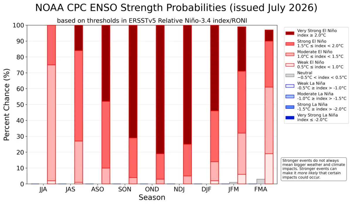
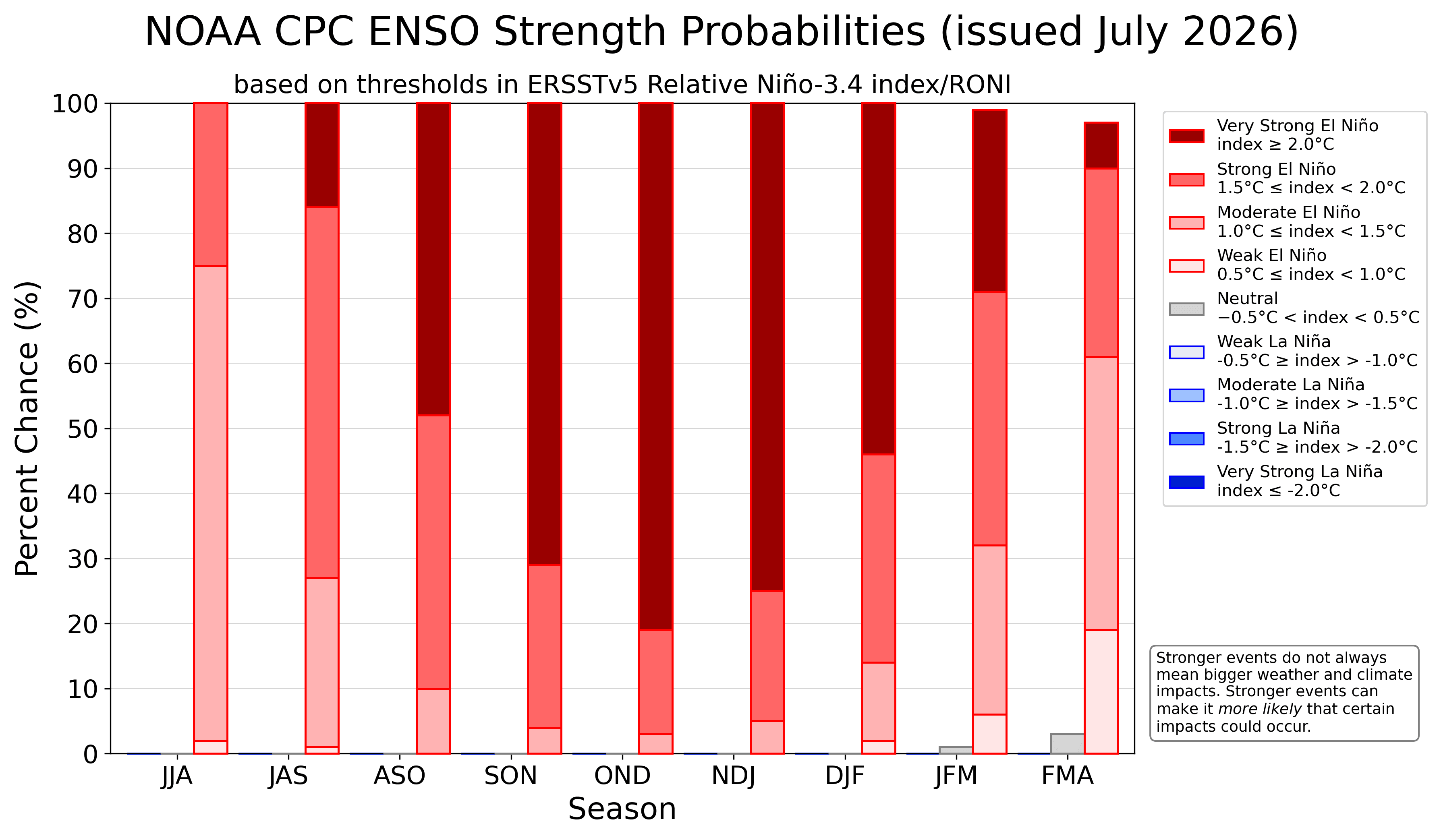
The latest runs from the ECMWF and NOAA’s Climate Prediction Center (CPC) show unprecedented statistical backing for an extreme El Niño category.
- The ECMWF Ensemble: Projects seasonal anomalies staying firmly above the +2.0°C threshold through the core of winter, with a severe peak arriving late in the season.
- The NOAA NMME: Merging multi-model outputs from across the United States and Canada, the NMME confirms the early development of winter-like pressure anomalies, validating that the atmospheric bridge connecting tropical Pacific heat to North American weather is operating at maximum capacity.
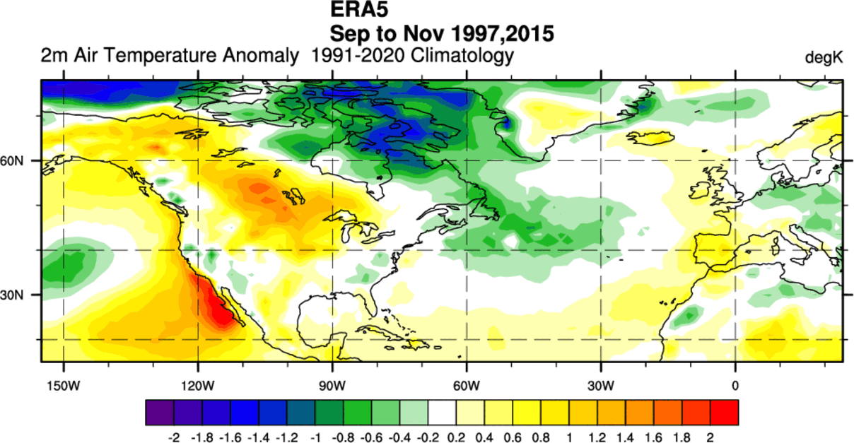
Lessons from Past Super El Niños
Because historical events of this magnitude are rare, forecasters examined the two most recent comparable Super El Niño cycles to map expected surface impacts:
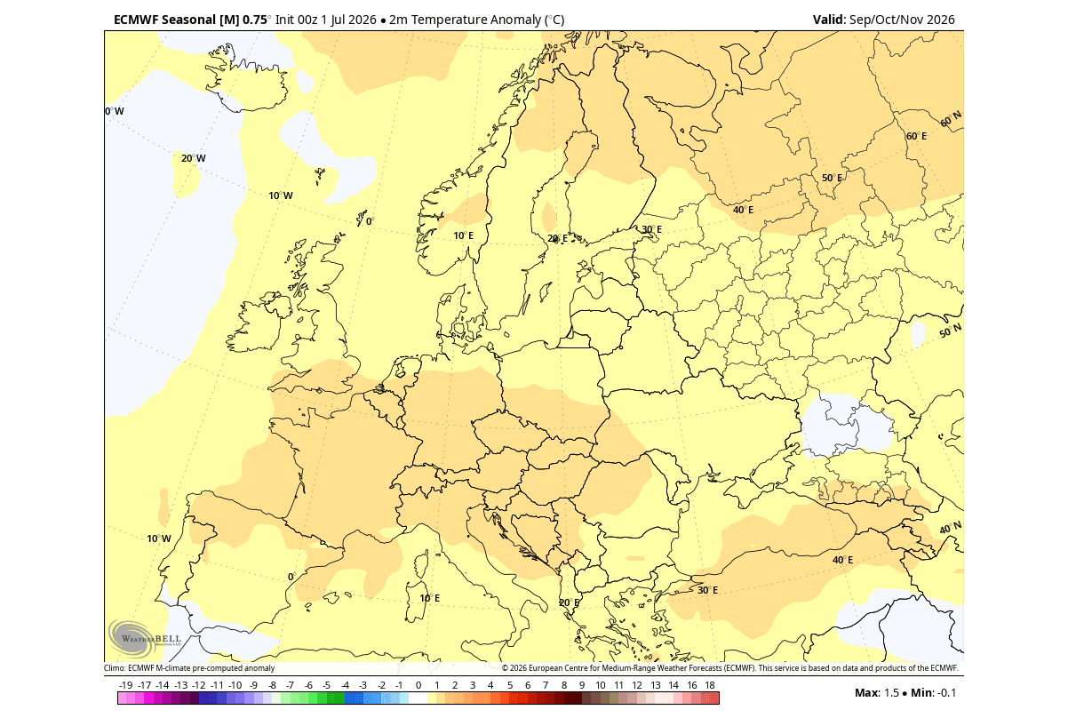
- Temperatures: Historically, these events produce above-normal autumn and winter temperatures across western and central Canada, the northern and central United States, and western Europe, driven by persistent Canadian ridging. Conversely, the U.S. West Coast, Southeast, and northern Canada experience moderated or cooler temperatures due to enhanced cloud cover and precipitation.
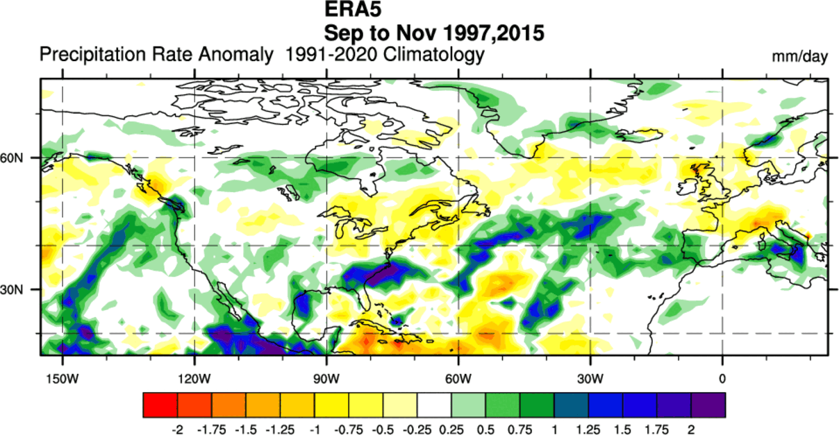
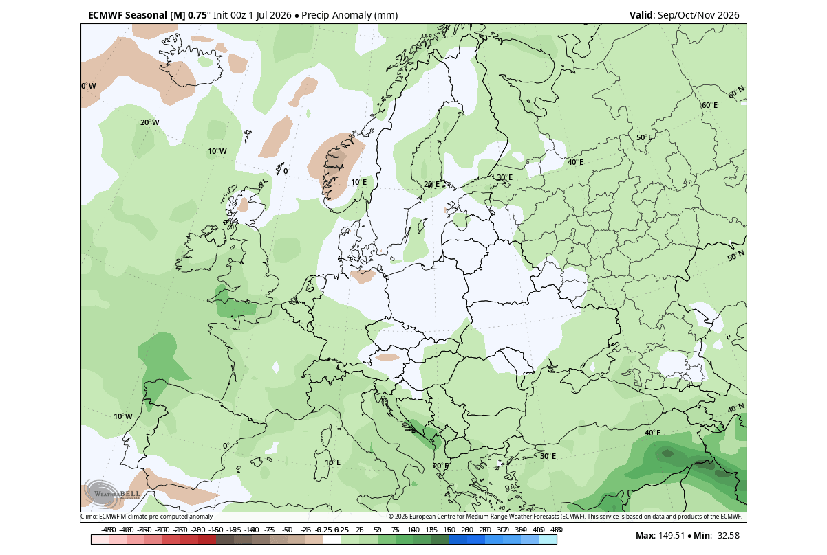
- Precipitation: An amplified subtropical jet stream consistently drives a surge in moisture and rainfall across the southern and central United States, extending into the Atlantic and soaking southern Europe. Meanwhile, regions like the Pacific Northwest and the U.S. Upper Midwest trend drier than average.
4. Official Responses and Institutional Outlooks
Major meteorological institutions have updated their long-range outlooks to account for the mounting atmospheric forcing.
The NOAA Climate Prediction Center (CPC) has maintained an overwhelming probability favoring an extreme El Niño classification for the 2026/2027 cold season. In official briefs, CPC forecasters have emphasized that the early season coupling between the ocean and the atmosphere leaves little doubt regarding the event’s global footprint.
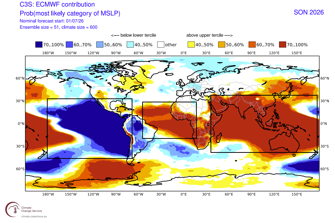
Similarly, European forecasting authorities emphasize that while Europe does not experience the direct localized teleconnections seen in North America, the continuous low-pressure signals stationed over the North Atlantic and northwestern Europe will dictate a stormy, mild, and unsettled pattern. Western and central European nations are advised to prepare for persistent westerly flow, high winds, and frequent precipitation events.
Furthermore, climatologists are closely monitoring stratospheric indicators. Historical data shows that Super El Niño phases drastically increase the statistical frequency of Stratospheric Sudden Warming (SSW) events in mid-winter. An SSW can trigger a total collapse or major displacement of the Polar Vortex, increasing the risk of severe, late-season cold air outbreaks spilling out of the Arctic into populated mid-latitude corridors.
5. Global Implications: What to Expect for Fall 2026 and Winter 2027
The cascading impacts of this historic Super El Niño will demand vigilance from emergency management, agricultural sectors, and energy markets across the Northern Hemisphere.
North America
- The United States: Expect a tale of two halves. The northern tier can anticipate a milder-than-average autumn and early winter protected by the Canadian high-pressure ridge. However, the southern, central, and eastern United States face a high-impact, active storm track. Supercharged by the subtropical jet stream, these regions face heightened risks of heavy rainfall, severe weather outbreaks, and—as January introduces potential cold air pathways—significant winter storm and snowfall potential.
- Canada: Predominantly warmer and drier conditions will dominate western and central provinces under the influence of the persistent mid-level atmospheric ridge.
Europe
- Mainland and Western Europe: The dominant meteorological driver will be a robust low-pressure zone hovering near the British Isles and northwestern Europe. This configuration acts as a atmospheric pump, driving relentless mild, moist westerly and southwesterly winds across the continent.
- Precipitation & Wind: Above-average rainfall is expected across western, central, and southeastern Europe, accompanied by an increased frequency of windstorms associated with active Atlantic low-pressure tracks. True winter cold will struggle to gain a lasting foothold across the continental interior unless major disruptions to the Polar Vortex alter the baseline westerly flow later in the season.
Agriculture, Energy, and Infrastructure
The early locking-in of these extreme seasonal patterns means that energy markets must prepare for fluctuating demand—mild conditions in northern heating zones contrasted with sudden, high-energy winter storms across the southern and eastern United States. Agricultural planners in drought-prone or flood-prone sectors must factor in the stark contrast between parched northern tiers and water-logged southern storm corridors.
As the 2026/2027 cold season approaches, meteorological communities will continue tracking every subtle shift in oceanic anomalies and stratospheric dynamics. Bookmark meteorological updates and stay tuned as this historic weather driver reaches its full, formidable potential.
