

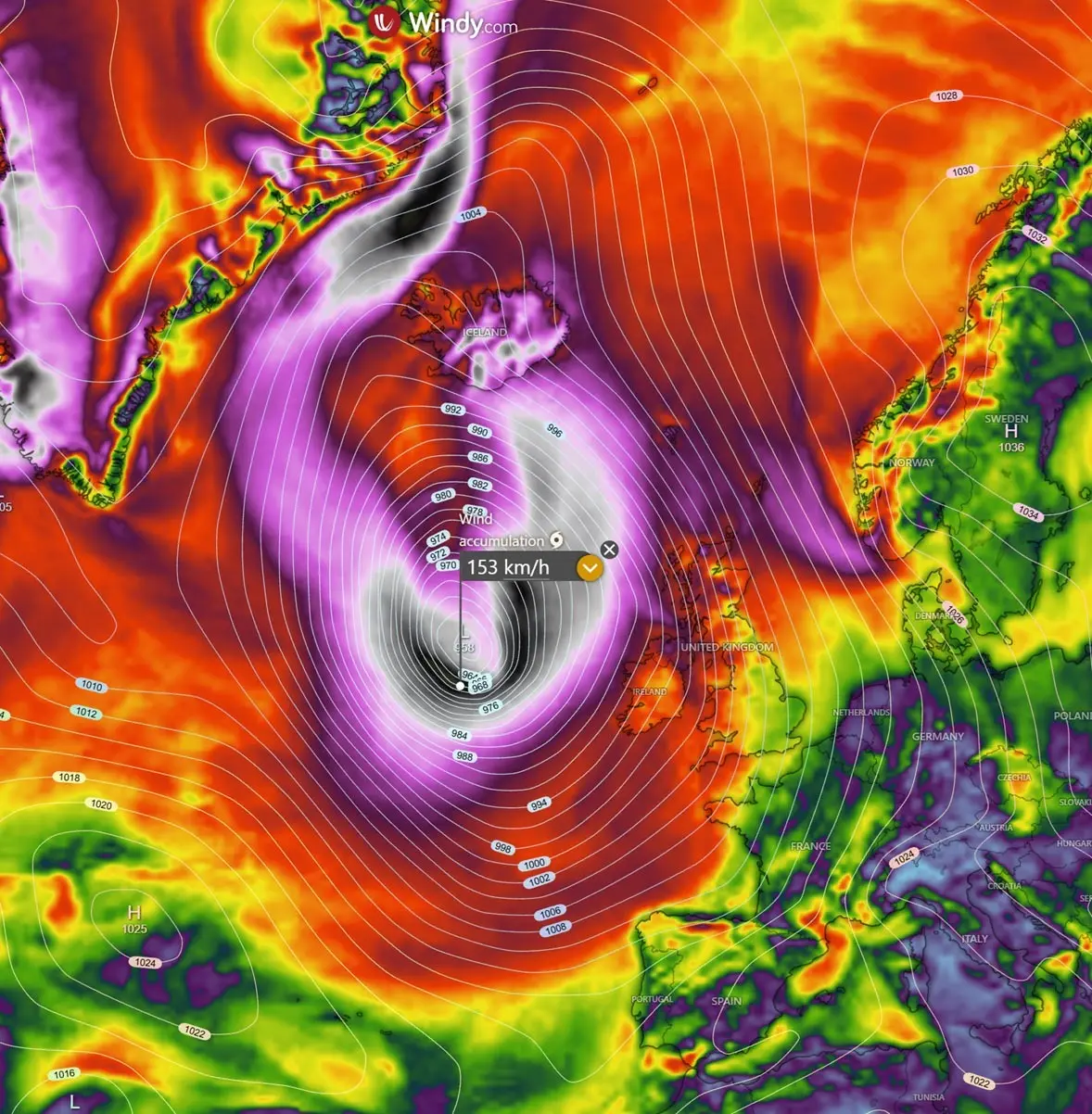
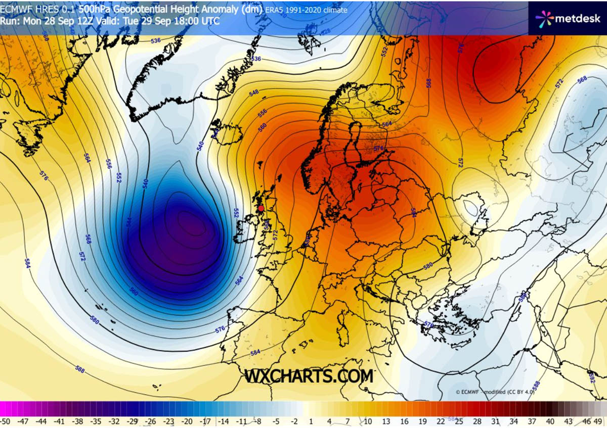
DUBLIN / REYKJAVÍK — A powerful meteorological phenomenon is currently unfolding across the North Atlantic, as a rapidly intensifying system prepares to slam into Western Europe. Forecasters are tracking a violent "bomb cyclone" fueled by a high-amplitude upper-level trough clashing against a stubborn, expansive 1035 hPa blocking high-pressure system anchored over Central Europe and Scandinavia.
The resulting severe baroclinic gradient is tightly squeezing isobars across the United Kingdom and Ireland, paving the way for severe gale-to-storm-force winds, intense squall lines, and towering Atlantic swells of up to 12 meters along exposed western coasts. While the core of the lowest pressure will track safely to the west of the UK and Ireland—passing north between Iceland and Scotland—the storm’s immense circulation footprint will affect millions across Western Europe through the remainder of the week.
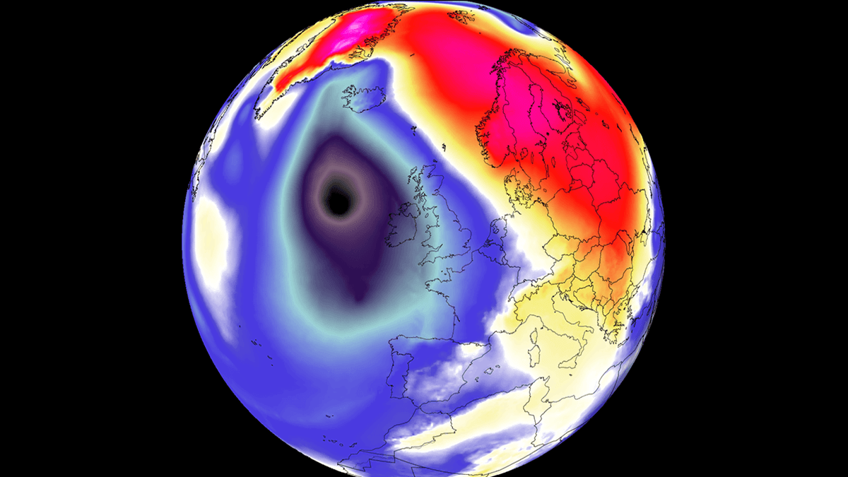
Main Facts: Anatomy of an Atlantic Bomb Cyclone
The driving force behind this severe weather event is a textbook case of explosive cyclogenesis, colloquially known as a "bomb cyclone." In meteorology, this classification is reserved for mid-latitude low-pressure systems whose central barometric pressure plummets by at least 24 millibars (mbar) within a 24-hour window.
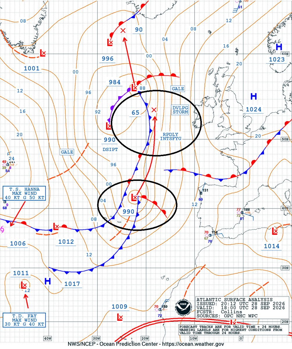
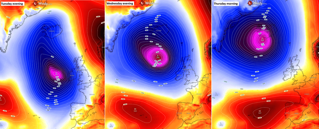
Data analyzed from the Ocean Prediction Center (OPC) indicates that the system’s central pressure started near 990 mbar on Monday evening, dropping precipitously to near 965 mbar by Tuesday evening, before bottoming out at a staggering sub-950 mbar core as it barrels northward toward the Faroe Islands and Iceland.
- Core Pressure: Expected to deepen to approximately 945–950 mbar by Wednesday midday.
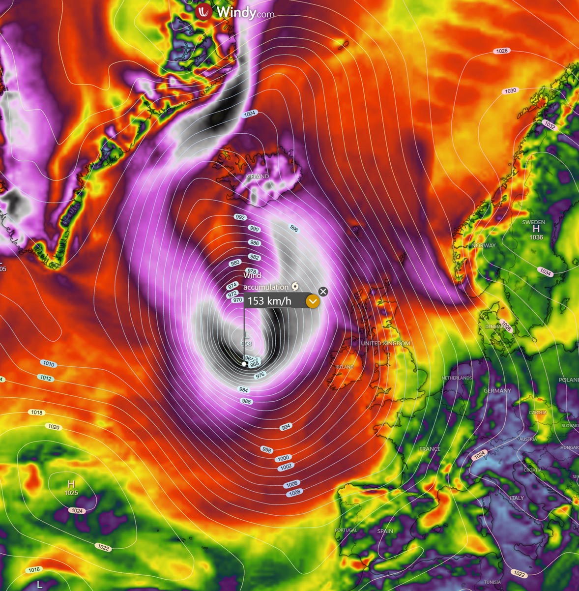
- Peak Wind Gusts: Ranging between 100 and 130 km/h across Ireland, Northern Ireland, Scotland, and Western England, with winds near the core surpassing 150 km/h.
- Marine Hazards: Significant wave heights of 8 to 12 meters threatening Atlantic-facing shores, particularly west of Ireland, Scotland, and the Outer Hebrides.
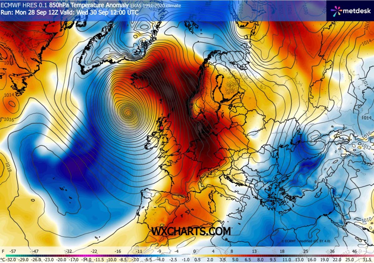
- Thermal Anomalies: A powerful southerly wind anomaly pulling an unseasonably warm air mass northward toward Scandinavia, Denmark, and the Faroe Islands.
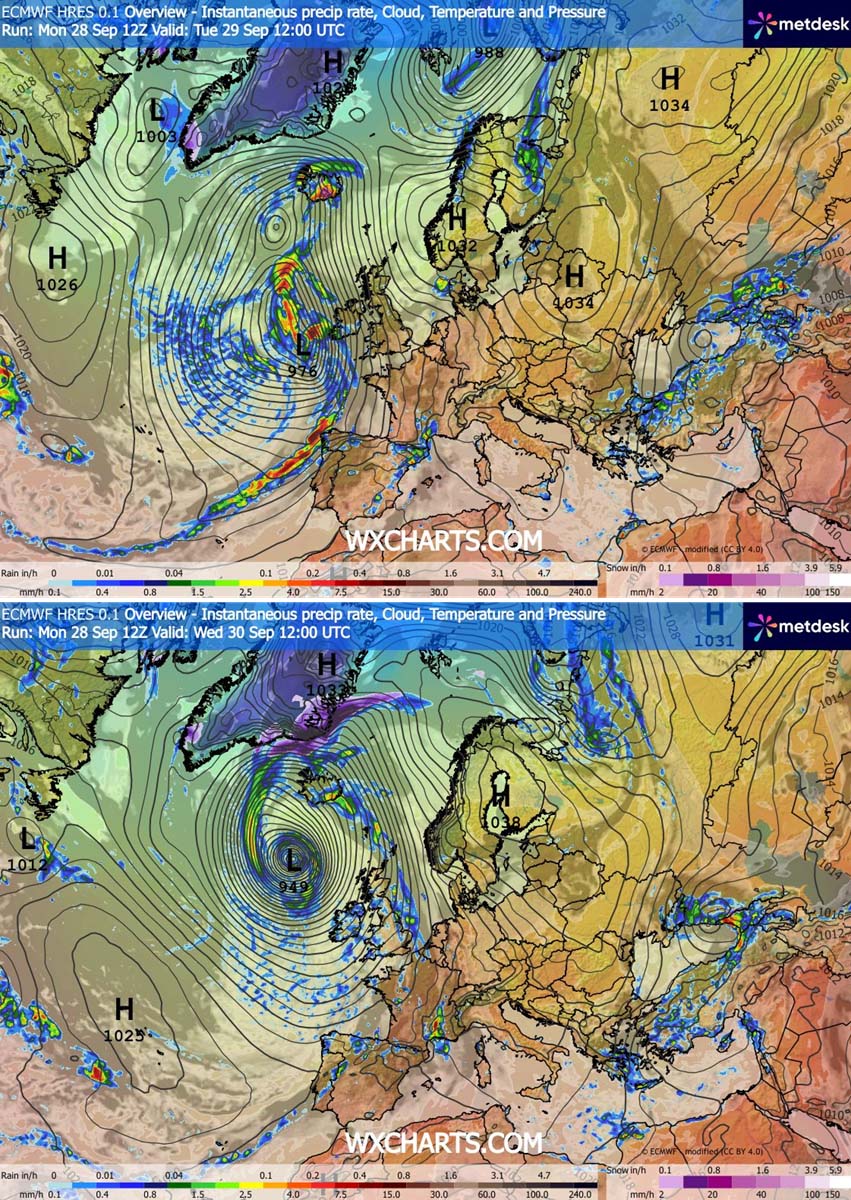
- Extreme Precipitation: Severe orographic rainfall targeting southern and southeastern Iceland, where totals could locally reach 250 to 300 mm.
Chronology of the Storm: From Genesis to Landfall
Monday: Satellite Signatures and Initial Intensification
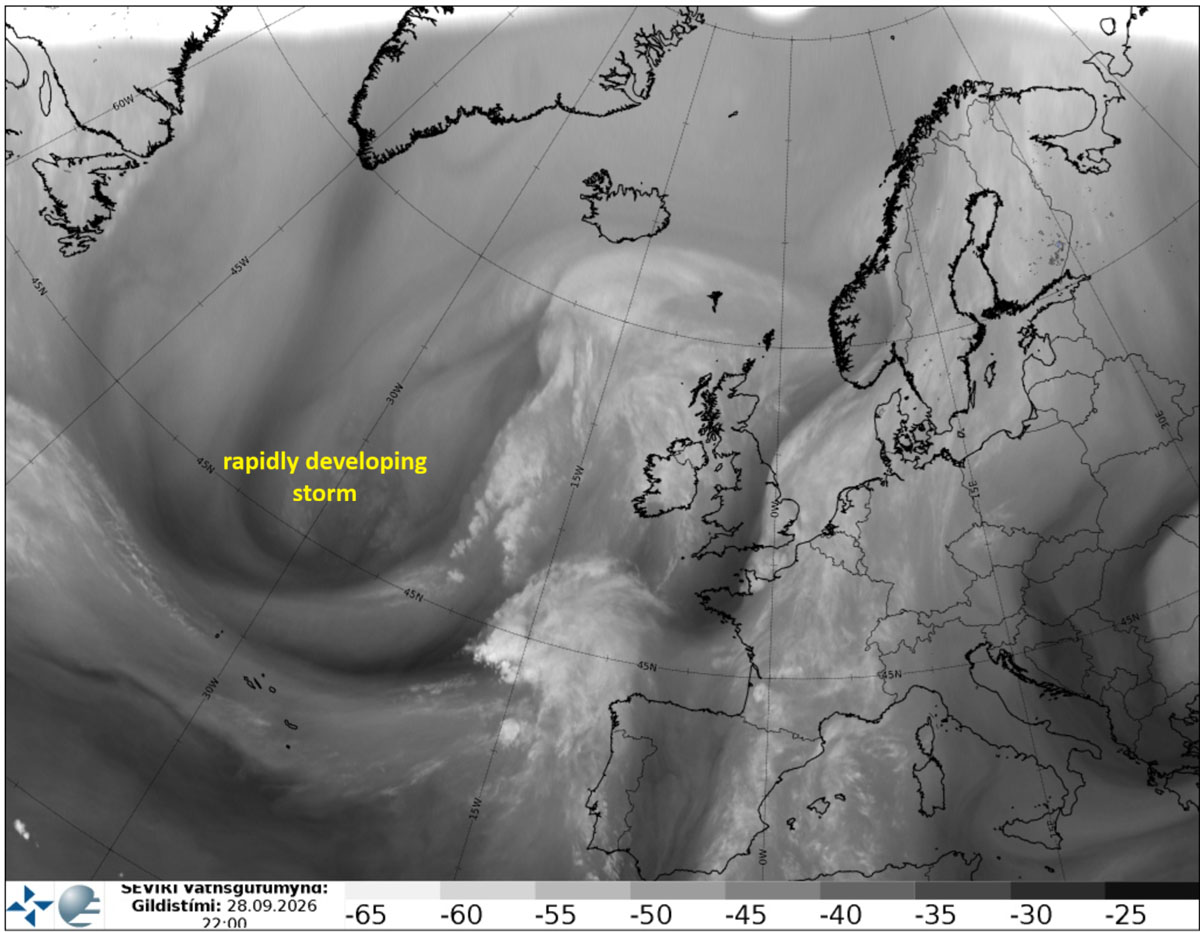
The rapidly developing storm first exposed its signature characteristics on satellite imagery late Monday. Water vapor spectrums highlighted a vigorous baroclinic zone coupled with a strengthening jet stream streaming out of the North Atlantic. Meteorological models immediately picked up on the steep pressure drops, confirming that standard low-pressure parameters were being bypassed in favor of explosive bombogenesis.
Tuesday: Warnings Issued as Gales Approach
By Tuesday morning, the system began aggressively organizing as it approached the western edge of Europe. Meteorological agencies across the affected regions elevated their advisory levels.
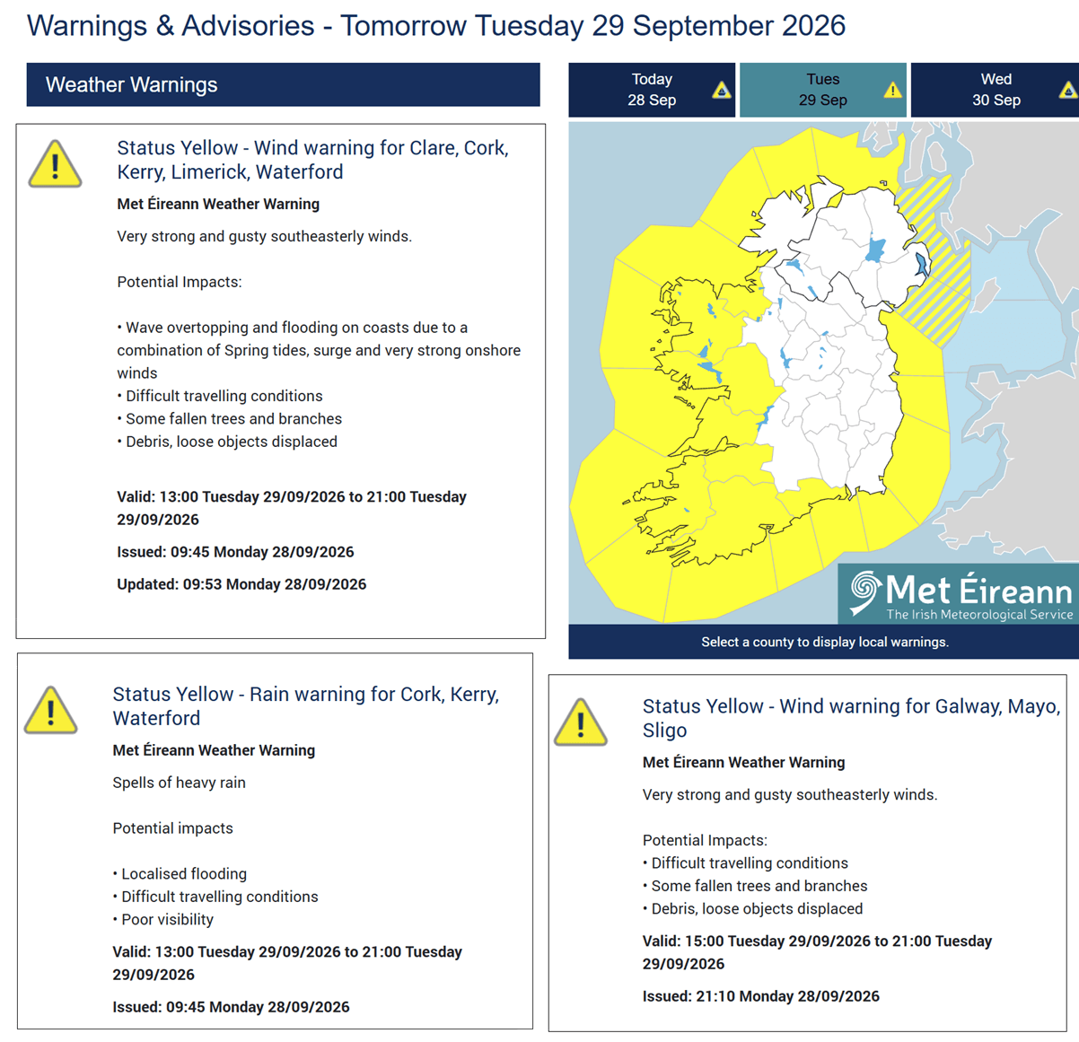
In response to the rapidly approaching gale-force winds, Met Éireann issued yellow weather warnings for coastal regions of Ireland and Northern Ireland. The alerts emphasized hazardous driving conditions, localized flooding, and the high probability of falling trees due to saturated soils meeting sudden, powerful southeast gusts.
Simultaneously, a fast-moving surface cold front began sweeping east across Ireland, Northern Ireland, and Scotland, triggering sharp rain squalls and localized wind disruptions.
Wednesday: Peak Intensity and Near-Hurricane Conditions
Midweek marks the peak of the system’s destructive potential. As the low-pressure center tracks north past the west of the Faroe Islands, its central pressure drops below 950 mbar. A tightly wound pressure gradient wraps around the core, generating near hurricane-force winds.
While the UK and Ireland begin to transition into the storm’s trailing wind fields, the extreme weather focus shifts aggressively northward. The storm’s massive circulation draws a warm air plume deep into Northwestern Europe, while the system’s forward momentum targets Iceland for a direct and punishing landfall by Thursday morning.
Thursday: Icelandic Landfall and Gradual Dissipation
By Thursday, the storm system is slated to make landfall over Iceland. Because of the storm’s trajectory and the persistent, powerful south-southeasterly jet stream establishing an atmospheric river, Iceland faces an extended period of severe weather. The system will begin to slowly weaken late Thursday and into Friday as it moves further inland and encounters less favorable thermodynamic conditions.
Supporting Meteorological Data and Dynamics
To understand the severity of this event, meteorologists have pointed to a classic Omega blocking pattern over the European continent. This persistent high-pressure anchor over Scandinavia and Central Europe has acted as a brick wall, forcing the incoming Atlantic trough to dig exceptionally deep south before curving violently back to the north.
Pressure and Wind Swaths
Surface-front forecasts illustrate the sheer scale of the system. On Tuesday afternoon, the low approaches Ireland, driving a robust cold front across the Irish Sea. By Wednesday afternoon, the sub-950 mbar center boasts a tight rotational footprint. Peak wind-gust models indicate a destructive swath where winds will exceed 150 km/h, primarily affecting open marine environments, coastal cliffs, and elevated terrain in the Scottish Highlands and western Irish coastlines.
Marine and Wave Dynamics
The vast fetch and sustained strength of the storm have generated catastrophic marine conditions. Numerical wave models highlight a massive swath of 10-to-12-meter significant wave heights tracking around the core of the system. Western coasts of Ireland, Northern Ireland, and the Scottish Outer Hebrides are bearing the brunt of 8-to-10-meter breaker zones, creating severe coastal erosion risks and rendering maritime navigation extremely perilous.
Temperature and Rainfall Anomalies
While wind has dominated early headlines, the thermodynamic profile of the storm is equally remarkable. On the eastern flank of the low, a powerful warm-air advection anomaly is pumping unseasonably warm air far north into the Arctic Circle, Denmark, and Scandinavia.
Conversely, rainfall distribution is lopsided. While the frontal passages across the UK and Ireland are swift and relatively low-accumulation, Iceland faces a massive precipitation threat. Due to the sustained atmospheric river interacting with local topography, southern and southeastern Iceland are bracing for persistent, heavy orographic rainfall. Projections from weather models like Vedur IS indicate localized accumulations of 250 to 300 mm, raising serious concerns for flash flooding and sudden river surges.
Official Responses and Public Safety Measures
With yellow and orange-tier warnings active across multiple jurisdictions, civil defense and emergency management authorities have urged the public to exercise extreme caution.
- Transport Disruptions: National transport authorities in Ireland and the UK have warned commuters of potential delays, flight cancellations at regional airports, and restrictions on high-sided vehicles crossing exposed bridges and viaducts.
- Maritime Advisories: Port authorities have restricted small craft operations, recalling fishing fleets and commercial vessels as sea states deteriorate rapidly.
- Infrastructure Readiness: Local councils have mobilized maintenance crews to clear storm drains in anticipation of heavy downpours and prepared chainsaw units to swiftly clear blocked roadways from downed timber.
- Icelandic Preparedness: In Iceland, the Icelandic Meteorological Office (Vedur IS) has maintained high-level alerts, advising residents in southern and southeastern districts to secure outdoor property and avoid unnecessary mountain travel as the atmospheric river bears down.
Broader Implications and Long-Range Context
This violent mid-latitude cyclone does not occur in a vacuum. Climatologically, the transition from late summer into autumn frequently triggers vigorous jet stream activity over the North Atlantic as temperature gradients between the equator and the polar regions begin to sharpen. However, the intensity of this specific bombogenesis event highlights the volatility of the current Atlantic basin pattern.
Furthermore, long-range forecasters note that this storm unfolds against a backdrop of historic global climate anomalies, including a record-breaking Super El Niño phase currently influencing global atmospheric circulation patterns for the 2026/2027 winter season. While direct attribution of individual storms to broader oceanic cycles remains complex, the heightened energy levels within the North Atlantic jet stream continue to test the resilience of coastal infrastructure across Western Europe.
Residents and travelers in the affected regions are strongly advised to monitor real-time updates from official meteorological services—including Met Éireann, the UK Met Office, and Vedur IS—and utilize tracking tools such as Windy and Wxcharts as the severe weather event runs its course.
