

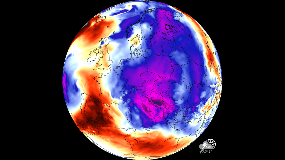
EUROPE — After enduring a historic, grueling stretch of excessive heat that strained urban infrastructure, triggered urban heat islands, and produced relentless tropical nights across the continent, a dramatic and welcome atmospheric shift is underway. A dynamic upper-level flow is ushering in a significant temperature downturn, delivering much-needed cold refreshment to the eastern half of Europe. While Central Europe, Poland, Hungary, Romania, and the Balkans finally experience a profound break from intense heat stress, the contrast across the continent remains stark, with parts of southwestern Europe continuing to swelter under dangerous, record-breaking temperatures.
Main Facts: The Great European Temperature Reversal
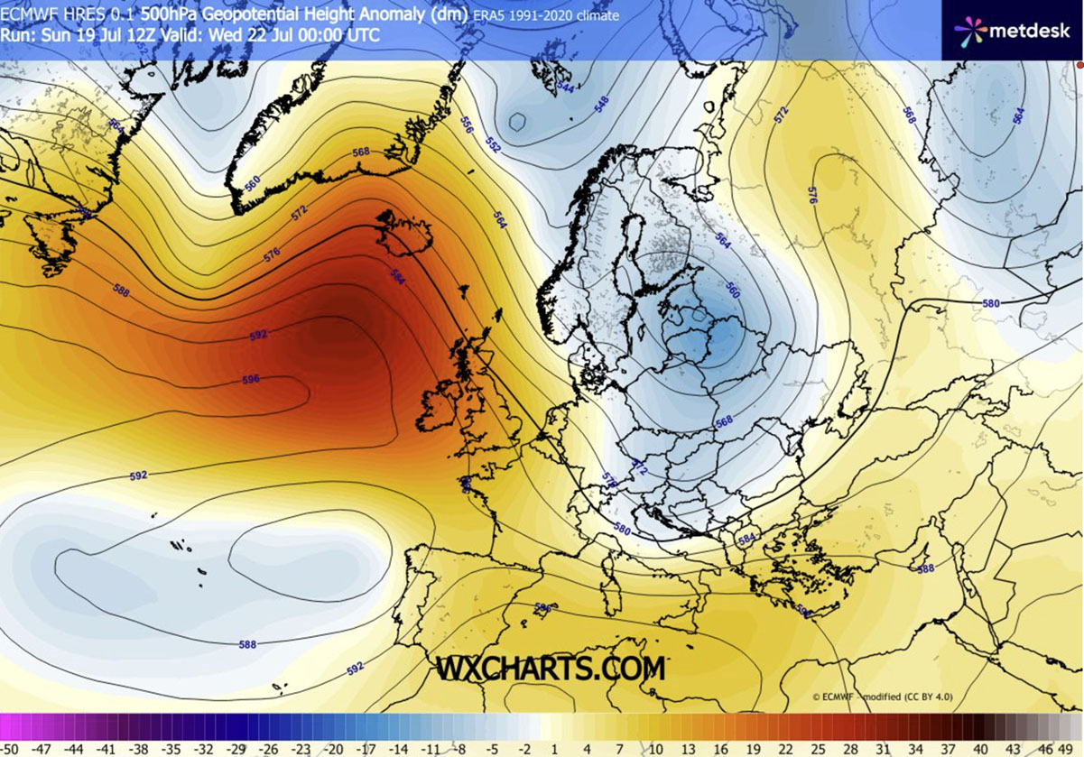
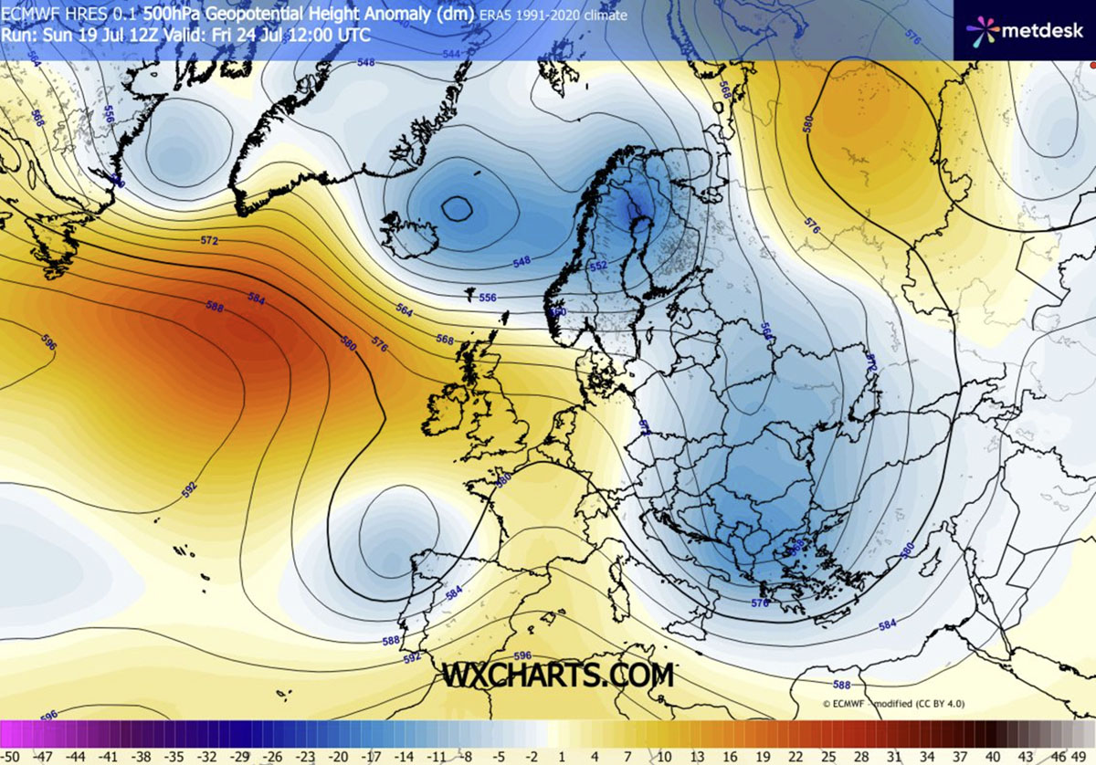
The overarching meteorological narrative centers on a high-amplitude pattern shift. A strengthening upper-level ridge anchored over the Atlantic Ocean has forced a deep, unseasonably cold trough to develop over northern Europe, subsequently plunging southward into the heart of the continent.
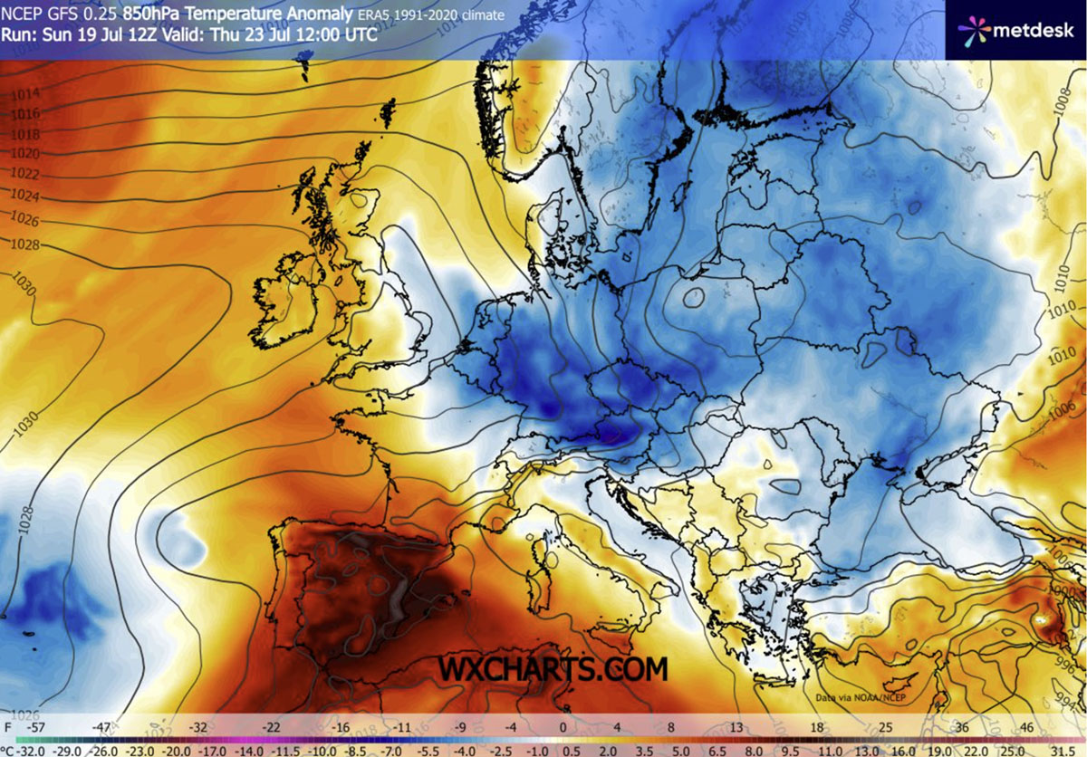
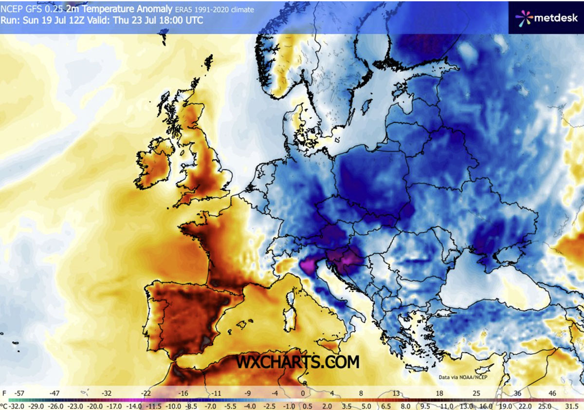
- The Core Shift: Central and Eastern Europe, which recently battled severe heatwaves, are seeing daytime highs plummet below 30°C (86°F). By mid-to-late week, large swathes of the region will experience temperatures sitting 4°C to 8°C below historical averages.
- Geographical Divide: While nations from Germany and Poland down to the northern Balkans and Italy find relief, southwestern Europe—specifically Spain and Portugal—remains locked in a persistent dome of extreme heat, with temperatures continuing to soar into the low 40s Celsius.
- Meteorological Drivers: The surface pressure response features notable geopotential falls to the east paired with higher pressure under the western ridge. This meridional flow drags cold, unstable air masses directly from the far north down into the Balkans and the Eastern Mediterranean.
- The Catch (Wildfire Risks): Although the incoming air mass brings a refreshing drop in humidity and temperature, much of the transition is characterized by dry, windy conditions. Consequently, cumulative drought stress keeps the threat of wildfires exceptionally high in spite of the cooler ambient air.
Chronology of the Shift: Mid-Week to Weekend Progression
The evolution of this weather pattern follows a distinct timeline, beginning with the initial breakdown of the heat dome and culminating in a deep, persistent cold wave across the southern tier of Eastern Europe.
Mid-Week (Wednesday – Thursday): The Initial Plunge
The cold front clears Central Europe by Wednesday, introducing gusty winds and rapidly falling heights. By Thursday, the most pronounced temperature anomalies—spanning 4°C to 8°C below normal—take hold across northern Italy, Slovenia, Croatia, Austria, Czechia, Slovakia, and Poland. Morning and nighttime temperatures drop dramatically into the low-to-mid 10s Celsius (50s Fahrenheit), offering urban residents a vital window to cool down overheated concrete structures and homes that have trapped heat for weeks. Daytime highs across the Benelux union, Germany, Poland, and the northern Balkans retreat comfortably into the low-to-mid 20s Celsius.
Late Week (Friday – Saturday): Deepening Trough and Storm Development
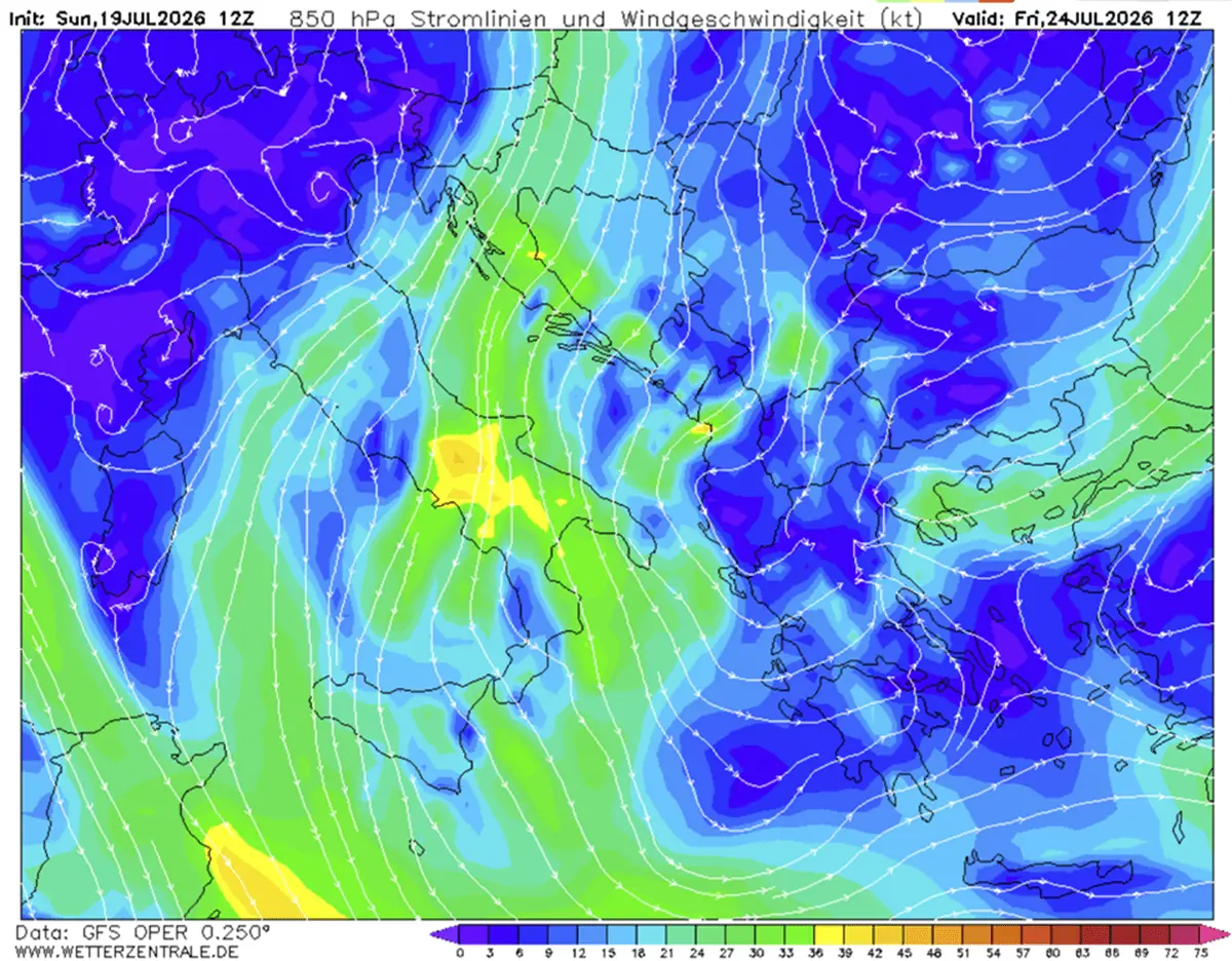
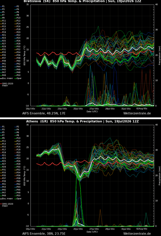
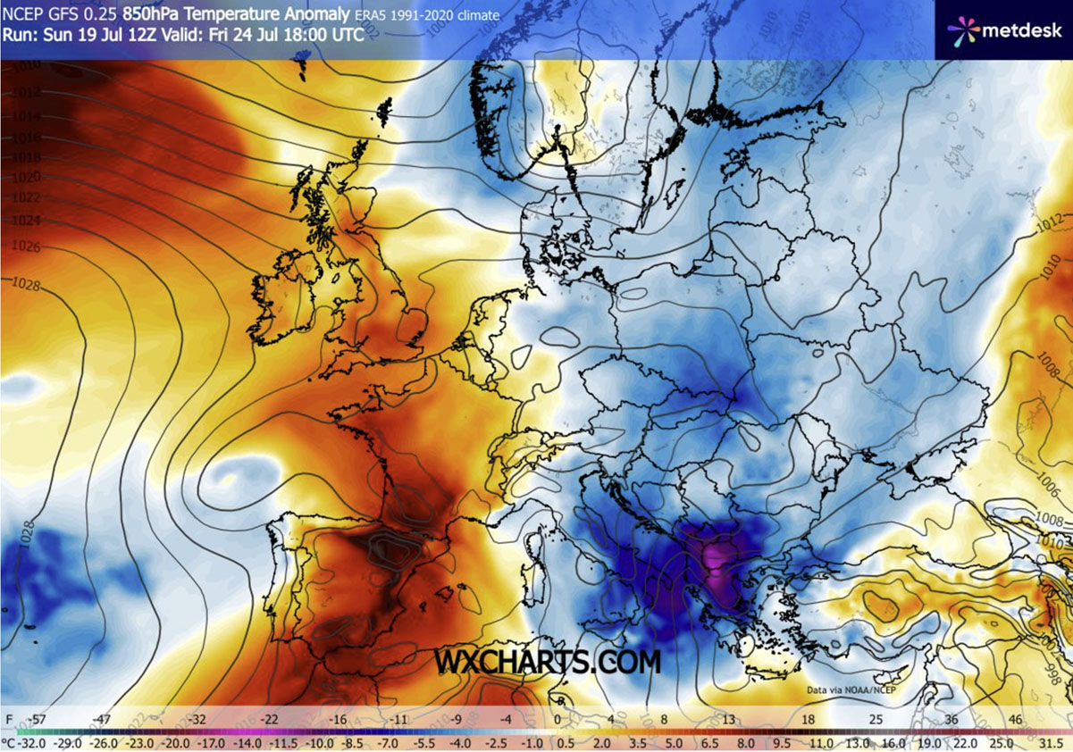
By Friday and Saturday, the core of the upper-level trough digs deep into the southern Balkans, southern Italy, and Greece. In these regions, atmospheric temperatures in the lower troposphere (at the 850 mbar level) drop to an impressive 10°C to 12°C below normal.
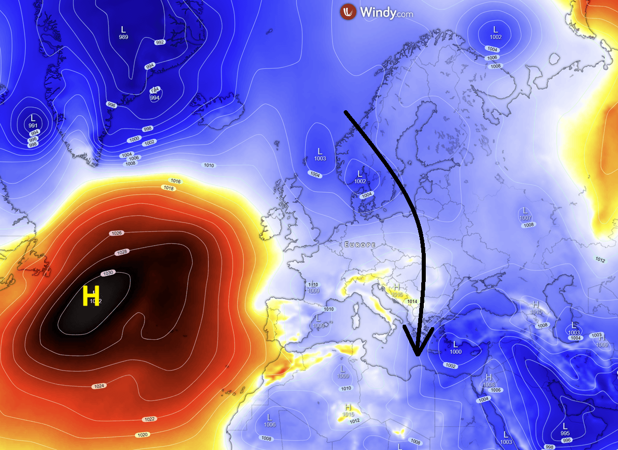
This dramatic clash between advancing cold air and lingering Mediterranean heat creates high atmospheric instability (CAPE). Consequently, Friday and Saturday bring a heightened threat of severe thunderstorms and localized heavy downpours, particularly stretching from the southern Balkans across Greece, Romania, the Black Sea, and Ukraine. Meanwhile, a secondary zone of stormy, wet weather persists across northeastern Europe, where cold northerly winds sweep over the relatively warm Baltic Sea.
Supporting Data and Meteorological Analysis
Meteorological models and telemetry illustrate the sheer scale of this atmospheric disruption during late July:
- Surface and Upper-Level Anomalies: The 850 mbar temperature anomaly maps highlight a deep blue plume stretching from Scandinavia all the way to the Ionian Sea by Friday. This indicates an air mass far more typical of early autumn than peak summer.
- Temperature Extremes Extremes:
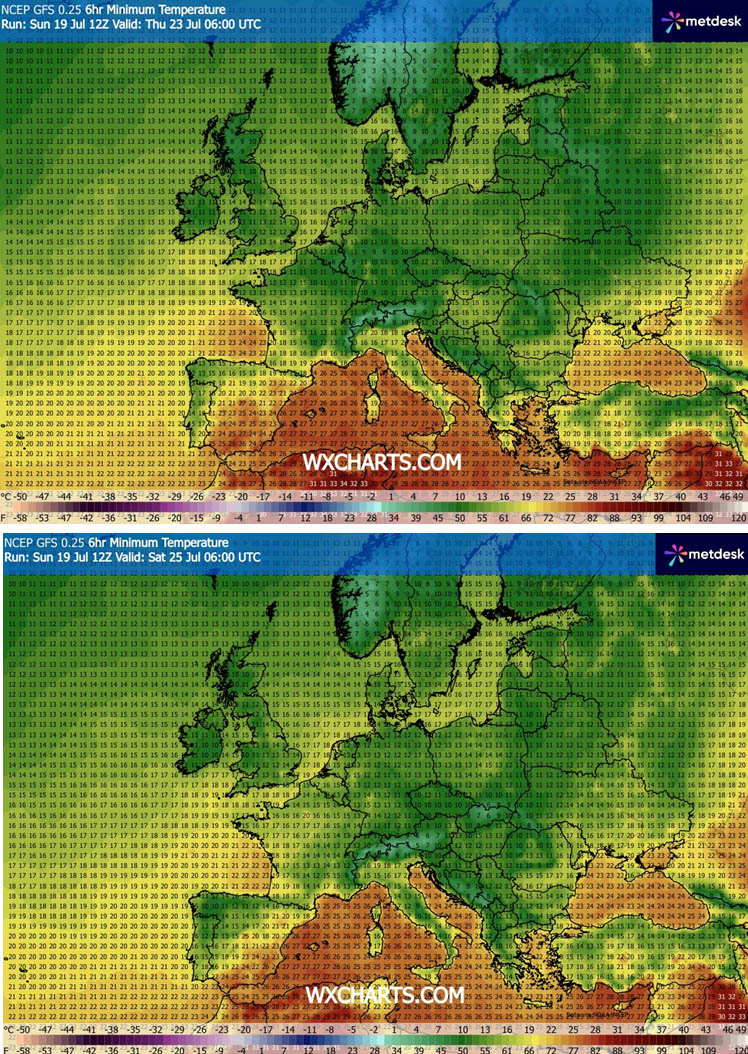
- Minimum Temperatures ($T_min$): Clear, wind-sheltered valleys across Central and Eastern Europe will see overnight lows dip well into the mid-to-high teens or lower, providing a stark contrast to the oppressive tropical nights of early July.
- Maximum Temperatures ($T_max$): Even in traditionally hot southern zones like Greece, Turkey, and southern Italy, peak daytime temperatures on Friday will be capped in the lower 30s Celsius. Conversely, the Iberian Peninsula remains an isolated furnace, with Spanish and Portuguese interior valleys maintaining maximums consistently in the 40s Celsius.
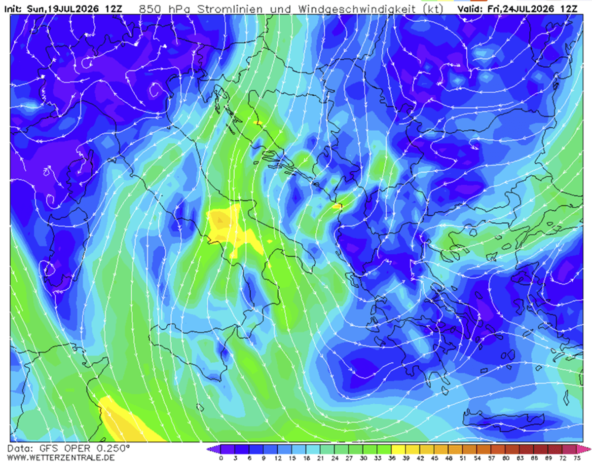
- Wind and Pressure Gradients: The tight pressure gradient established between the Western European ridge and the Eastern European trough generates sustained, brisk winds from Wednesday through Saturday. While these winds amplify the cooling sensation, they simultaneously strip moisture from soils, exacerbating agricultural dryness.
- Precipitation Totals: Rainfall accumulation charts point to localized relief across the southern Balkans and the Black Sea basin, though meteorologists emphasize that these convective storms will be hit-or-miss and insufficient to reverse deep-seated hydrological drought conditions.
Official Responses and Public Sector Implications
Municipalities, emergency services, and tourism boards across Central and Eastern Europe have adjusted their postures in response to the sudden meteorological pivot:
- Energy Grid and Infrastructure Relief: Power grid operators in countries like Poland, Hungary, and Romania reported immediate relief as residential and commercial air conditioning loads dropped from record-shattering peaks back toward seasonal norms. Urban planners noted that the persistent "urban heat island" effect—which kept city centers dangerously warm even past midnight—has temporarily abated.
- Tourism and Public Health: With the continent in the middle of peak summer holiday season, tourism sectors in the northern Balkans and coastal Adriatic regions welcomed the break. Public health advisories, which had spent weeks warning citizens about heatstroke and cardiovascular stress, shifted from emergency heat warnings to standard summer safety guidelines.
- Wildfire and Forestry Alerts: Despite the plunge in air temperature, forestry and civil protection agencies in Croatia, Greece, and neighboring nations maintained high-to-extreme wildfire alert levels. Officials stressed that weeks of preceding dry weather combined with mid-week gusty winds create a volatile environment where a single spark can still ignite rapid-spreading blazes. Firefighting aviation assets remain on standby across the southern tier.
Broader Implications: A Fractured European Summer
This late-July weather event underscores a broader climatological trend of amplified, highly meridional flow patterns across the Northern Hemisphere. Persistent atmospheric blocking over the Atlantic Ocean continues to lock extreme anomalies in place—delivering unseasonal cold waves to the east while compounding extreme, lingering heat domes over the Iberian Peninsula.
For the millions of residents, travelers, and agricultural workers spanning from the Baltic states to the southern Balkans, this week serves as a brief, restorative pause. However, as meteorological forecasts hint at further pattern evolutions heading into August, the continent remains on high alert for the next phase of a volatile summer season.
Meteorologists are continuing to monitor the developing extreme heat setup over Spain and Portugal, with further updates expected shortly.
