

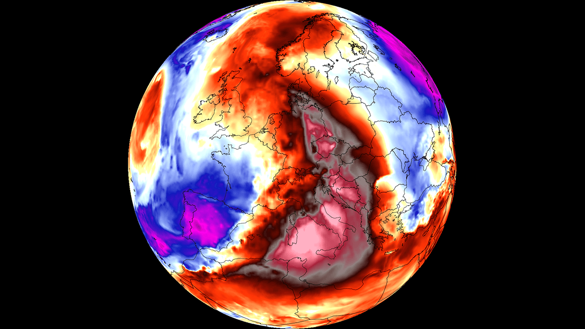
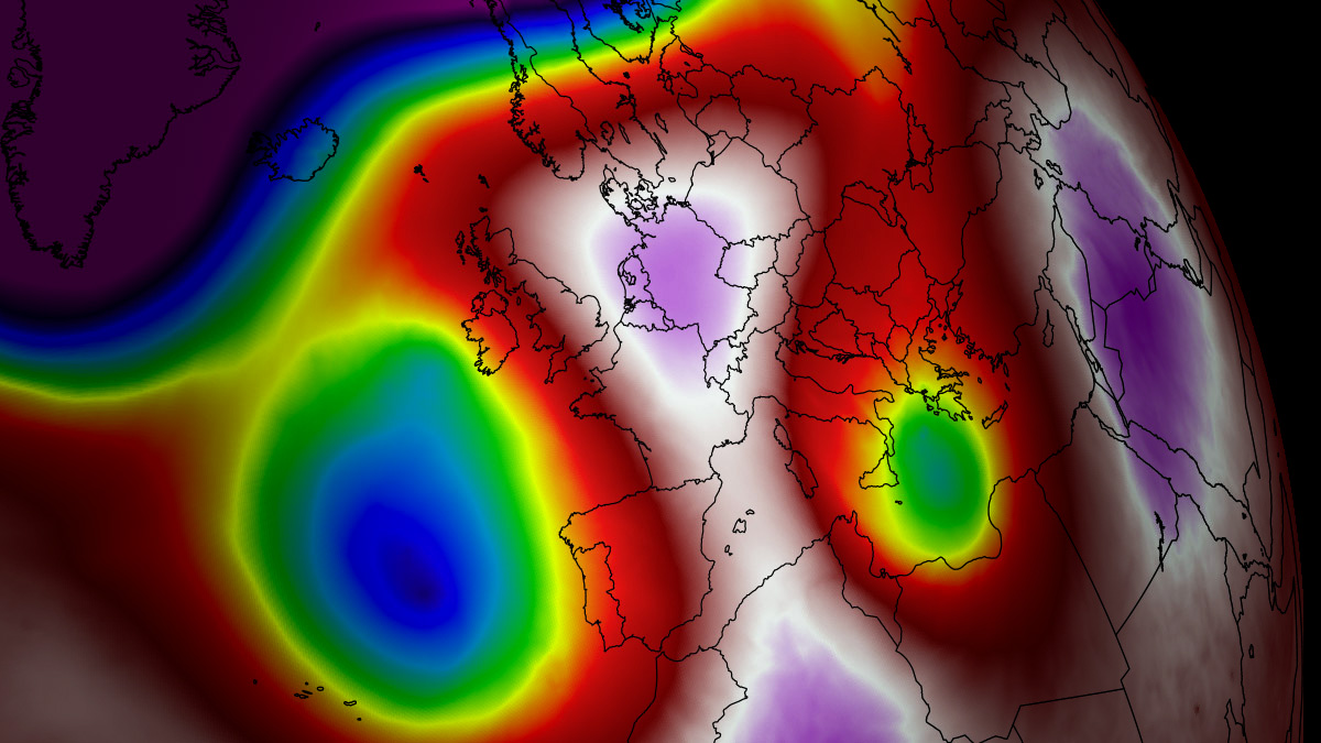
EUROPE — As summer enters its final stretch, a stubborn and exceptionally powerful atmospheric blocking pattern has anchored itself across the Central Mediterranean and Southern Europe. This system has spawned yet another severe "Heat Dome"—marking the sixth major heatwave to grip the continent this season.
Fueled by a stubborn high-pressure ridge originating over North Africa, the late-summer thermal surge is sending temperatures soaring well past 40°C in several low-lying river basins and plains. While Southern and Central Europe bear the brunt of the blistering daytime highs and suffocating "tropical nights," the sharp thermal gradient is simultaneously setting the stage for a violent outbreak of severe thunderstorms across France and the western Alps.
Main Facts
- Sixth Major Heat Dome: Europe is currently enduring its sixth powerful heatwave of the 2026 summer season, driven by a persistent upper-level blocking high-pressure system.
- Extreme Temperatures: Peak afternoon surface temperatures across low-lying river basins, the Po Valley, and the Pannonian plains are forecast to reach between 38°C and 43°C (100°F to 109°F).
- Nocturnal Stress: Major urban corridors are experiencing "tropical nights," with overnight lows refusing to drop below 22°C to 26°C (72°F to 79°F), denying residents vital physiological relief.
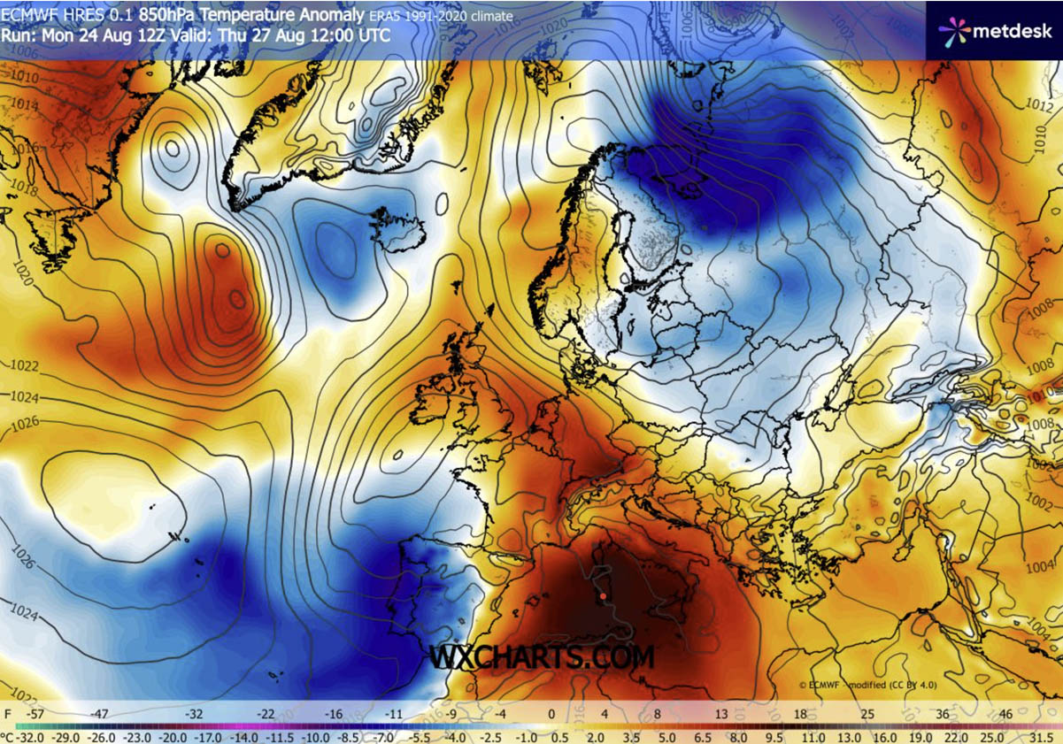
- Temperature Anomalies: Forecasts indicate widespread 2-meter surface temperatures running 12°C to 16°C above long-term climate norms for late August.
- Collateral Severe Weather: The severe contrast between the Mediterranean heat dome and a deep Atlantic trough over the Bay of Biscay is triggering extreme instability (3,000 to nearly 5,000 J/kg of CAPE), threatening France and the western Alps with destructive supercells, giant hail, severe winds, and tornadoes.
Chronology of the Event: The Week’s Progression
Early Week: The Ridge Builds North
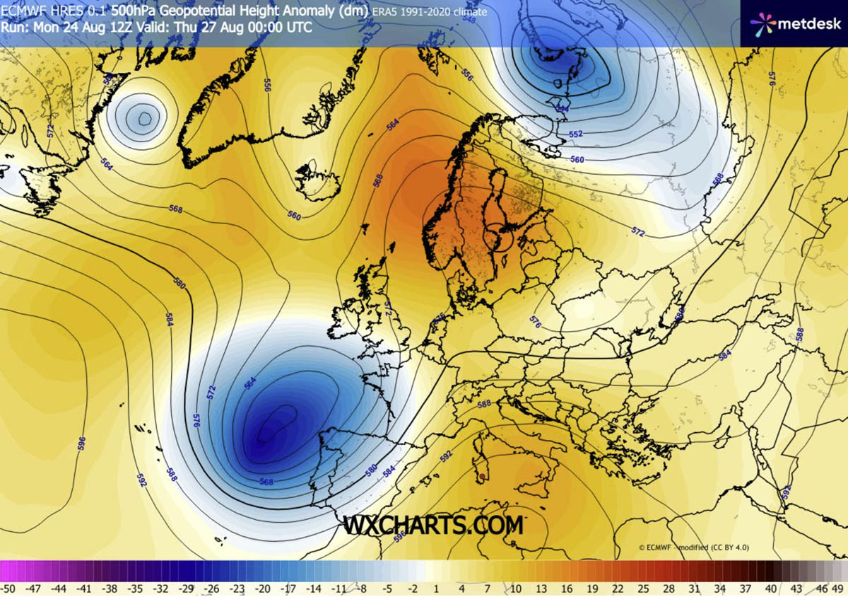
The atmospheric engine behind the current crisis began forming earlier in the week as an unseasonably strong upper-level ridge pushed northward from North Africa into the Mediterranean basin. Reinforced by a deep, cold trough of low pressure parked over the Bay of Biscay and western Iberia, the North African plume was forced to expand aggressively into Central Europe and the Balkan Peninsula.
Mid-Week Peak (Thursday to Saturday)
The heart of the heatwave is peaking between Thursday and Saturday.
- Thursday: The thermal surge pushes across the Alps into Germany, bringing localized daytime highs of 32°C to 36°C. Simultaneously, the sharp pressure gradient between the Iberian trough and the Mediterranean ridge unleashes violent wind shear over France, creating prime conditions for a severe weather outbreak.
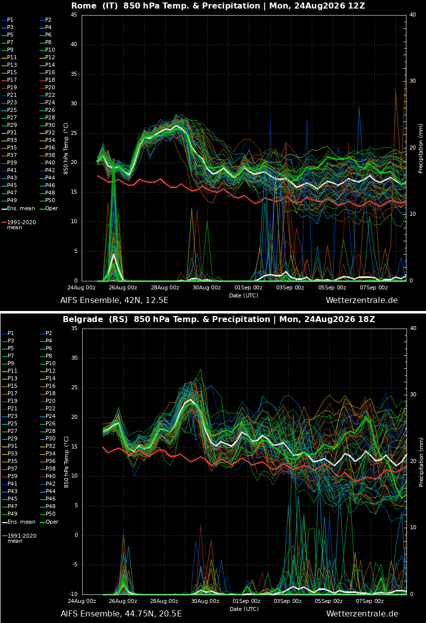
- Friday: Italy and the central Balkans bear the brunt of the heat. Temperatures in the Po Valley, Bosnia, Serbia, and Croatia surge into the low 40s (Celsius), challenging historical end-of-August records.
- Saturday: The heat dome elongates and shifts eastward, driving extreme temperature anomalies into Poland, western Ukraine, and the remainder of the Balkan Peninsula. Meanwhile, a cooler maritime air mass begins bleeding into Western Europe, offering relief to Portugal, Spain, and eventually France.
Supporting Data and Meteorological Dynamics
How a Heat Dome Operates
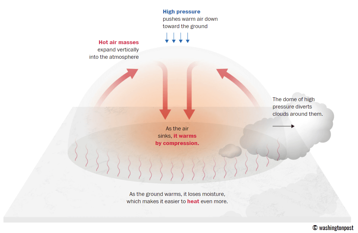
Meteorologists classify this phenomenon as a "heat dome" due to the mechanics of the persistent upper-level high-pressure ridge (often referred to as an "omega block" pattern). Operating much like a lid on a pot, the system traps massive pockets of warm air at all tropospheric levels.
As the air is forced downward, it undergoes adiabatic compression—meaning it is compressed and heated as atmospheric pressure increases near the surface. This sinking air also suppresses cloud cover, allowing uninterrupted, intense solar radiation to bake the terrain, rapidly accelerating soil moisture loss and desiccating vegetation.
Regional Temperature Breakdowns
- Southern Europe (Italy, Greece, and the Balkans): Peak temperatures are reaching 42°C to 43°C through Friday. The most extreme thermal anomalies are concentrated in Italy’s Po Valley, Hungary, northern Serbia, and parts of Bosnia and Herzegovina.
- Central Europe (Germany, Alps, Czech Republic, Slovakia): While Thursday saw temperatures spike into the mid-30s°C, a cooler Atlantic maritime front is arriving to suppress the heat from west to east by the weekend.
- Eastern Expansion (Poland, Ukraine): As the high-pressure system elongates over the weekend, anomalous heat will sweep into eastern and northeastern Europe.
Physiological Impacts, Infrastructure, and Health Implications
The immediate threat extends far beyond agricultural drought and dry soils; human health and public infrastructure are facing severe strain.
The Danger of "Tropical Nights"
While daytime highs grab headlines, meteorologists emphasize that the true danger lies in the lack of nighttime cooling. When overnight temperatures fail to dip below 24°C to 26°C, the human body cannot cool down or recover from daytime thermal stress. This cumulative exhaustion dramatically increases the risk of heat stroke, cardiovascular incidents (including heart attacks and strokes), and respiratory failure.
Vulnerable Populations and the Heat Index
Vulnerable groups—including the elderly, children, and individuals with pre-existing medical conditions—are at the highest risk. Furthermore, outdoor laborers such as construction workers and agriculturalists face extreme risks of heat exhaustion and dehydration. Urban populations living in densely built environments featuring concrete and asphalt experience the urban heat island effect, exacerbating the thermal load.
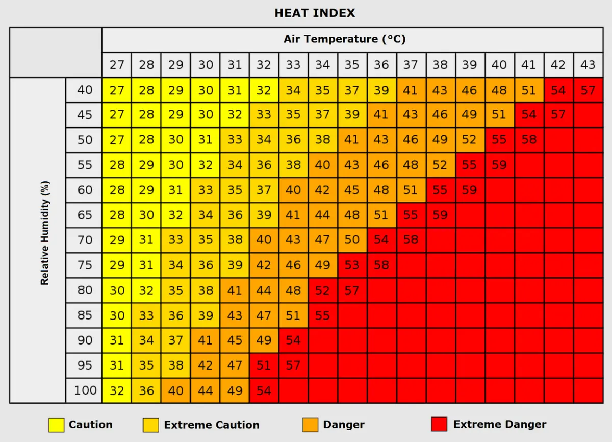
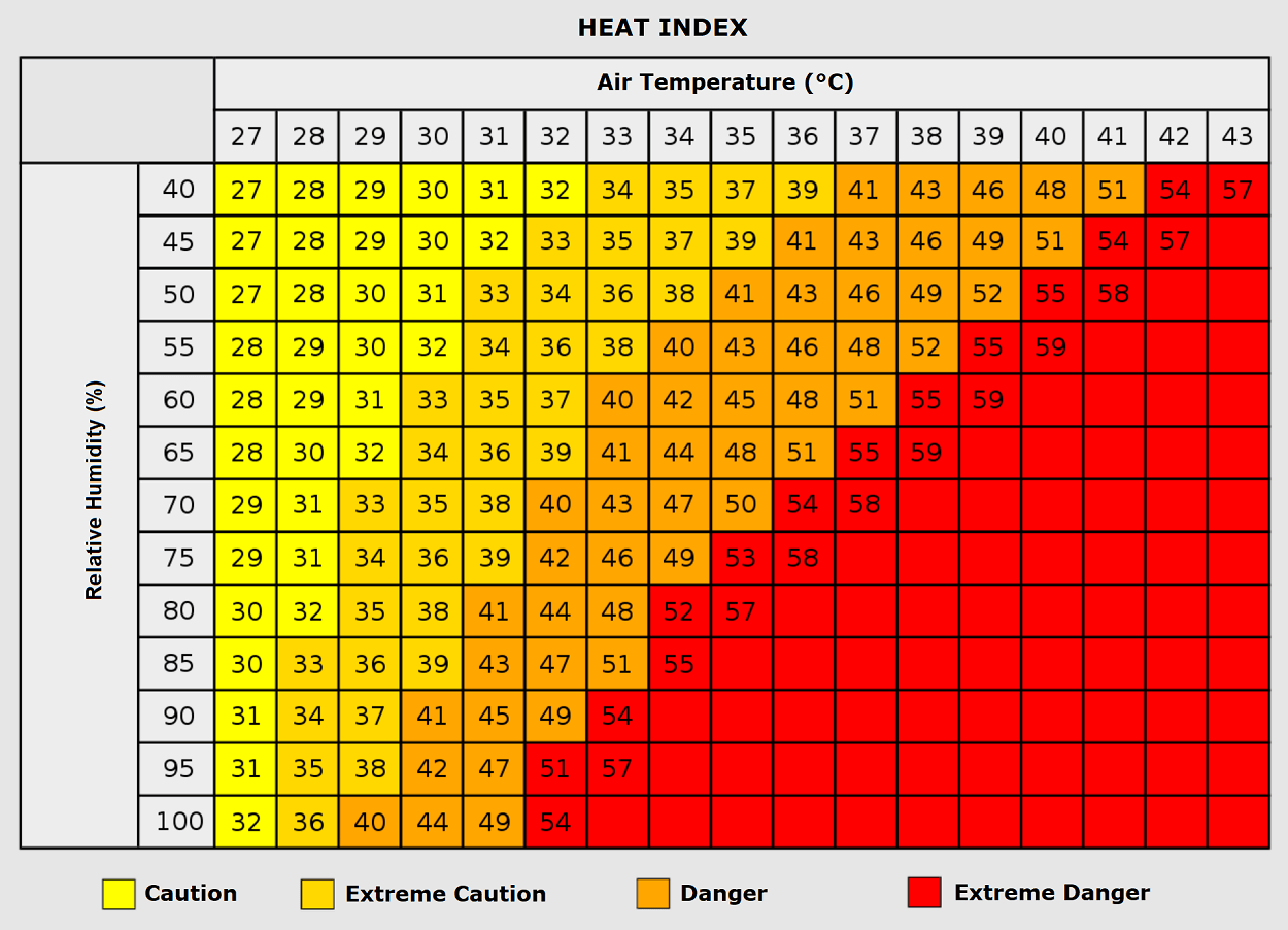
When high humidity accompanies these high temperatures, the apparent "Heat Index" skyrockets. An air temperature of 35°C combined with humidity levels exceeding 80% can make it feel closer to 50°C, rendering natural body cooling via perspiration virtually ineffective.
Collateral Threats: Severe Thunderstorm Outbreak in France
While Southern and Central Europe bake under stable high pressure, the western periphery of the heat dome is telling a drastically different, highly volatile story.
A deep upper-level wave lingering over the Bay of Biscay is interacting directly with the massive heat plume surging out of the Mediterranean. This interaction creates an extreme temperature and pressure gradient, supercharging the jet stream from eastern Spain across the western Mediterranean into France.
[Atlantic Maritime Air]
       vs.
[Mediterranean Heat Dome]
       ==> Extreme Pressure/Temperature Gradient
       ==> Strong Jet Stream (Wind Shear)
       ==> 3,000 - 5,000 J/kg CAPE
       ==> SEVERE THUNDERSTORM OUTBREAK (France & Western Alps)
Explosive Instability (CAPE)
Fuelled by an exceptionally warm Mediterranean Sea—itself the product of a historic summer of marine heatwaves—available convective potential energy (CAPE) is projected to reach between 3,000 and nearly 5,000 J/kg over parts of France and the western Alps.
When combined with intense vertical wind shear generated by the dynamic jet stream aloft, this high instability creates an environment ripe for explosive storm development. Forecasters warn of organized supercells capable of producing:
- Very large to giant hail
- Destructive straight-line winds
- Isolated tornadoes
- Torrential rainfall leading to flash flooding
Implications and Outlook
The persistence of six distinct heat domes over the course of a single summer highlights an increasingly recurring climate pattern characterized by stubborn atmospheric blocking events over Europe. These repeated thermal surges severely test the resilience of European energy grids due to surging air-conditioning demands, strain water resources, and elevate the risk of explosive wildfires across parched valleys.
As the current system slowly shifts eastward and begins to dissipate over the coming weekend, long-range meteorological models suggest that the broader European weather pattern will remain highly dynamic as the calendar flips into September. Authorities across affected nations continue to maintain orange and red heat advisories, urging residents to limit outdoor exertion, hydrate continuously, and monitor local weather alerts as the severe weather threats unfold.
