

Main Facts: A Historic Pacific Pattern Takes Shape
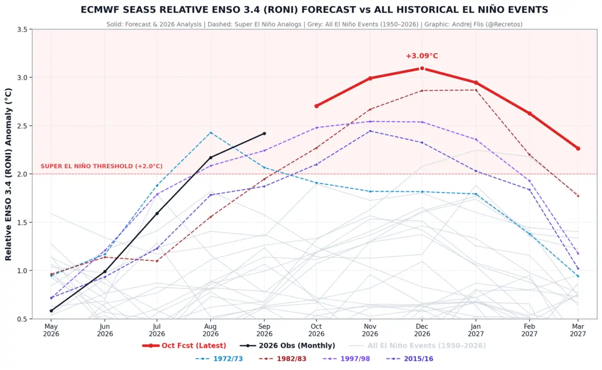
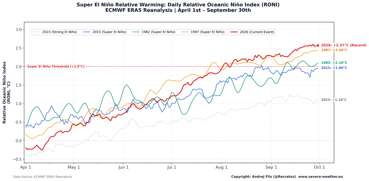
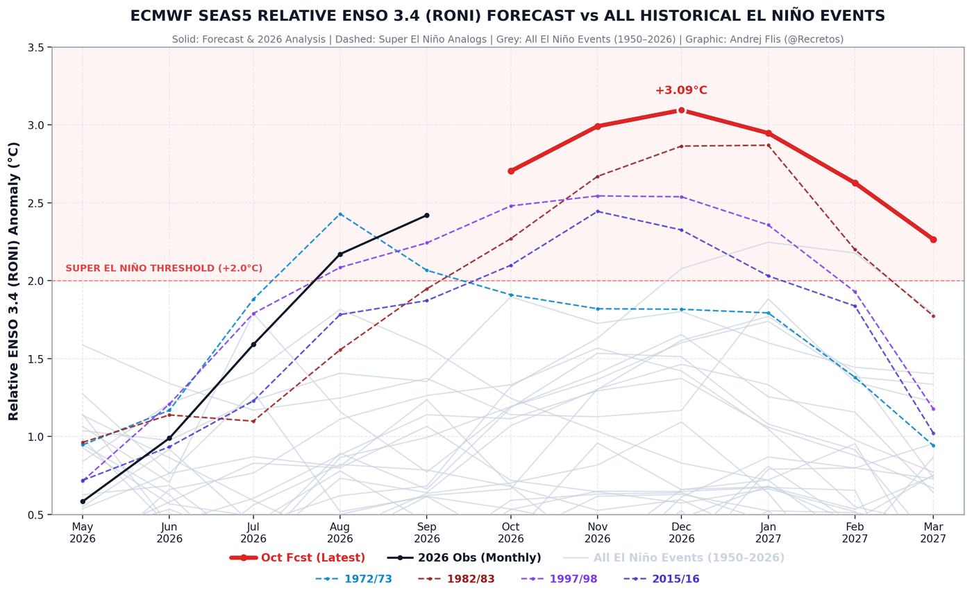
As meteorologists analyze the latest long-range telemetry for the upcoming winter, a massive and historically potent climate driver is moving toward its peak. A record-setting Super El Niño is building across the equatorial Pacific Ocean ahead of the December 2026 peak, tracking well above anomalies observed over the past 75 years.
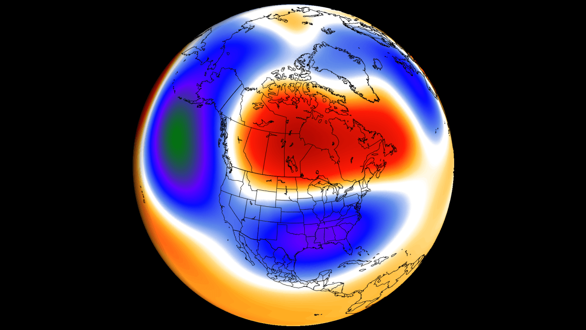
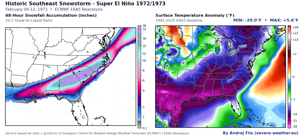
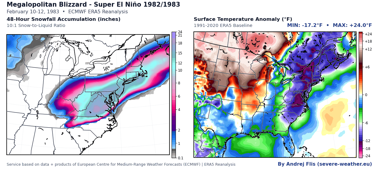
While public perception often assumes that El Niño winters translate uniformly to mild, snowless conditions across North America, historical precedent proves otherwise. Legendary winter weather events—such as the crippling East Coast "Megalopolitan" blizzard of February 1983 and the devastating mid-South snowstorm of 1973—both struck during major Super El Niño winters.
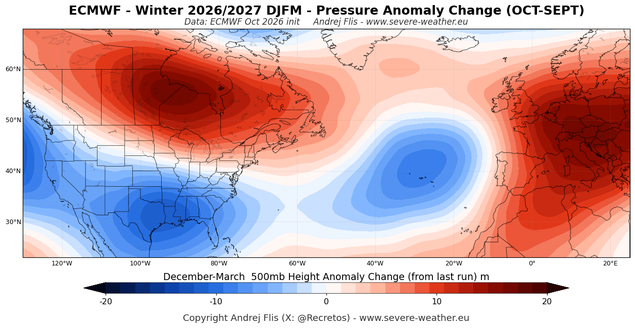
The updated October seasonal forecast models, utilizing advanced data from the European Centre for Medium-Range Weather Forecasts (ECMWF), reveal a significant shift toward an amplified atmospheric pattern. For Winter 2026/2027, the outlook points to:
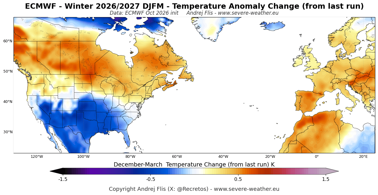
- A stark temperature and precipitation divide across North America, featuring mild conditions in the far northern U.S. and southern Canada.
- An active, stormy, and increasingly cold south-central and eastern United States.
- A heightened probability of a mid-winter Polar Vortex disruption, setting the stage for a potentially volatile, "backloaded" winter season peaking in February 2027.
- A predominantly mild, wet, westerly-driven pattern across mainland Europe, with heavy snowfall restricted primarily to high-elevation Alpine regions and the far north.
Chronology and Seasonal Evolution: Month-by-Month Breakdown
Understanding how a Super El Niño winter unfolds requires tracking its atmospheric evolution from late autumn through early spring. Seasonal modeling from the ECMWF maps out the progression of the 2026/2027 winter season:
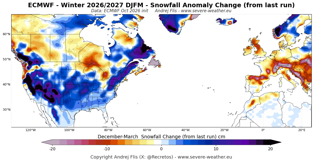
- December 2026: The season initiates under strong high-pressure ridging over Canada and the northern United States, resulting in a mild start for those regions. Simultaneously, a persistent southern low-pressure track establishes itself, funneling moisture into the Southeast and the Atlantic seaboard. Europe begins the season under a remarkably mild, westerly flow.
- January 2027: The atmospheric wave pattern amplifies significantly. The Gulf Coast and south-central United States begin to experience a transition toward cooler-than-normal anomalies. Meanwhile, the U.S. West Coast—particularly California—enters a wet phase driven by an energized Pacific jet stream. Northern Europe begins to exhibit signs of pattern shifts as low-pressure systems track out of the North Atlantic.
- February 2027: This month emerges as the focal point for winter dynamics. Model consensus from the ECMWF, alongside North American ensembles like the CFSv2 and CanSIPS, points to February as the coldest and snowiest month for the central, southern, and eastern U.S. Below-normal temperatures expand from the Southwest through the Southeast, driven by sustained blocking highs over Canada and an entrenched southern trough. Northern Europe trends near normal, while the southern continent remains mild.
- March 2027: Meteorological spring arrives with a relaxation of the extreme atmospheric pressure gradients. The U.S. transitions into a pattern of a mild northern tier and a slightly cooler southern half, while European weather conditions broadly return to persistent mildness.
Supporting Data: Record-Shattering Anomalies and Historical Precedents
The 2026/2027 Super El Niño: A 75-Year Record
Data compiled from NOAA Coral Reef Watch (CRW) and ERA5 reanalysis highlights the unprecedented velocity of the current El Niño event. Sea surface temperature (SST) anomalies in the key ENSO monitoring regions have surged, peaking well over 6°C (11°F) above normal in the eastern Pacific. When evaluated against historical metrics like the Relative Oceanic Niño Index (RONI)—a standardized index recognized by the World Meteorological Organization (WMO)—the 2026 event is tracking as the strongest El Niño since comprehensive modern records began in 1950.
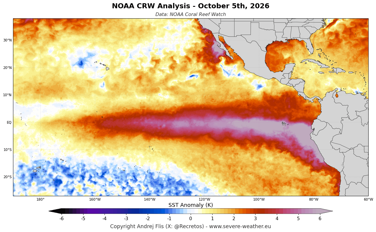
The WMO has placed the probability of this event persisting at near 100% through the entirety of the meteorological winter, warning of heightened risks for extreme global weather anomalies.
Lessons from Past Super El Niños
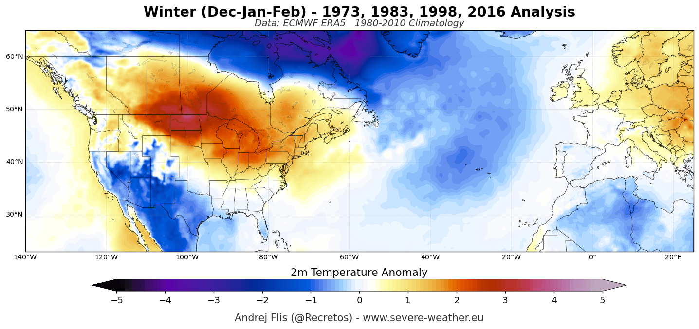
To understand the surface impacts of the upcoming season, climatologists examine the pressure and temperature fingerprints of the last four major Super El Niño winters:
- The Great Southeastern Snowstorm (1972/1973): A powerful Gulf low pressure system dropped up to 24 inches of snow in South Carolina and 16.5 inches in Georgia, with accumulations reaching as far south as Tallahassee, Florida.
- The Megalopolitan Blizzard (1982/1983): A violent nor’easter paralyzed the I-95 corridor from Washington, D.C., to Boston, dumping snowfall rates of 2 to 5 inches per hour. Baltimore and Philadelphia shattered their all-time 24-hour snowfall records with over 21 to 22 inches.
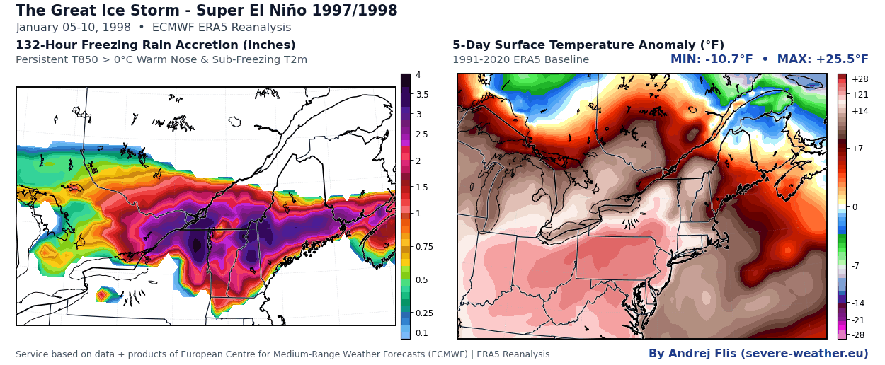
- The Great Ice Storm (1997/1998): Destructive freezing rain coated upstate New York, northern New England, and southeastern Canada, leaving up to 80% of Maine’s population without power—some outages extending past 20 days.
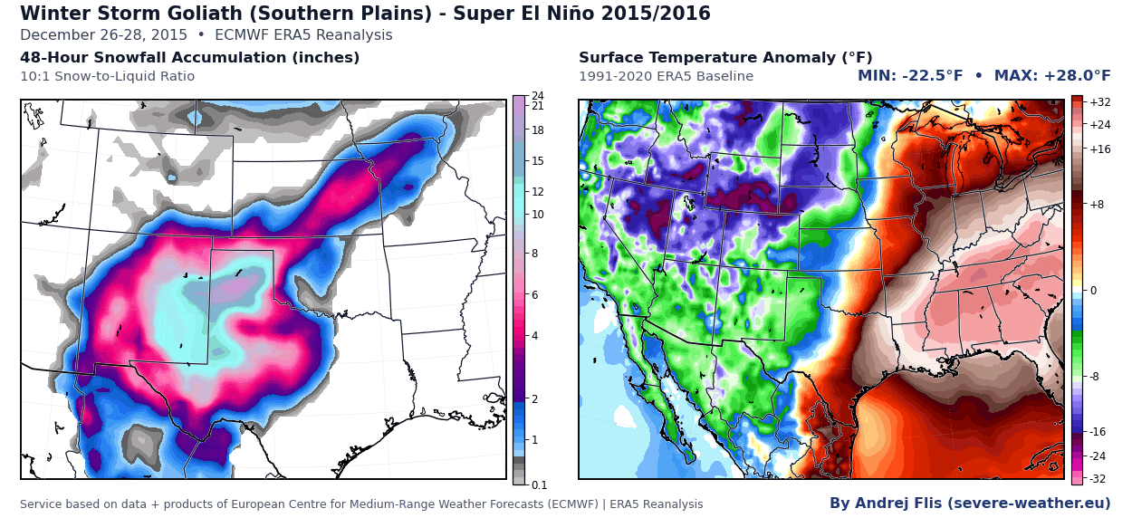
- The Christmas Weekend Blizzard & Historic Nor’easter (2015/2016): The southern storm track produced a historic 2-to-3-foot snowfall across the Southern Plains (New Mexico, Texas, Oklahoma) in late December, followed immediately in January 2016 by an East Coast nor’easter that dumped over 27 inches of snow in Central Park and 29 inches in Baltimore, impacting more than 100 million people.
Official Responses and Meteorological Outlooks
Forecasters and international bodies have issued coordinated outlooks regarding the structural behavior of the atmosphere for the upcoming months.
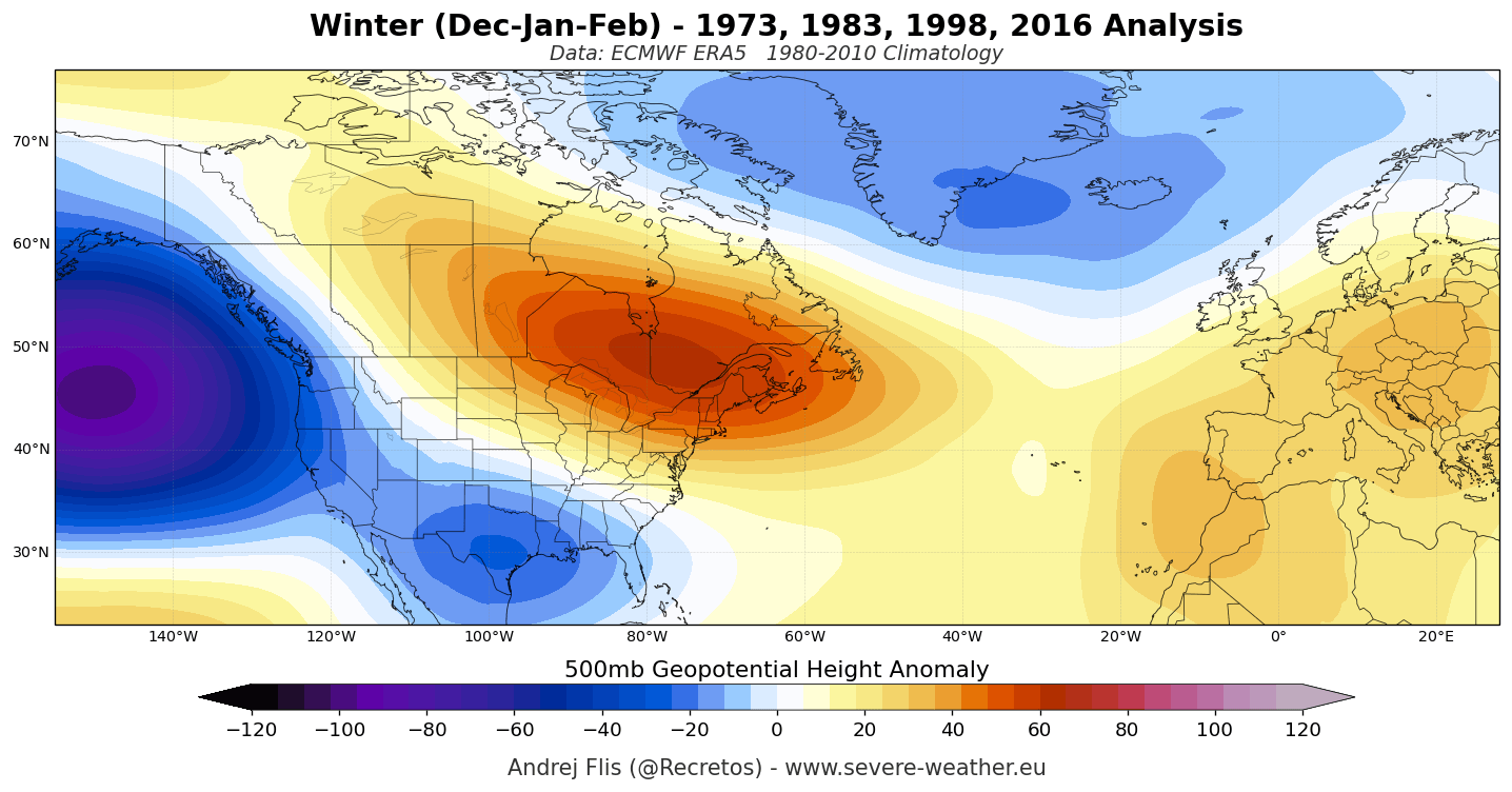
The primary driver of the North American winter is the Pacific Jet Stream. Driven by the immense thermal energy of the tropical Pacific anomaly, this jet stream forms a deep low-pressure highway across the southern tier of the United States. Concurrently, it forces a massive high-pressure blocking ridge over Canada and the Great Lakes. This configuration acts as a shield, deflecting frigid Arctic air masses away from the northern U.S. and southern Canada while sustaining a high-moisture storm track across the southern and eastern states.
For Europe, the atmospheric teleconnections are more muted. Because Europe’s weather is heavily dictated by North Atlantic oscillations, the dominant signal from a Pacific Super El Niño points toward a prolonged, mild westerly flow. Official European forecasts emphasize that while precipitation totals will likely run above average due to moisture streaming in from the Atlantic, actual snowfall accumulation will be heavily elevation-dependent, heavily favoring ski resorts in the high Alps (above 1,800 to 2,000 meters) and extreme northern latitudes.
Implications: The Polar Vortex Wildcard and Regional Outlooks
The Stratospheric Threat: A Mid-Winter Disruption
One of the most critical implications of the Winter 2026/2027 forecast is the behavior of the stratospheric Polar Vortex. The Polar Vortex acts as a fast-spinning ring of stratospheric winds trapping frigid air over the pole.
Recent ECMWF seasonal model runs indicate an unusual and notable weakening of these stratospheric westerly winds starting in late December and extending through mid-winter. When zonal winds drop significantly below long-term averages, the risk of a major Sudden Stratospheric Warming (SSW) event increases exponentially.
Research into past Super El Niño winters—such as 2015/2016—shows that strong early-season vortex configurations can experience rapid mid-winter breakdowns. When the Polar Vortex stretches or collapses, it frequently forces a dislodged core of polar air southward into the mid-latitudes. This phenomenon, often referred to colloquially as the "Polar Express" pattern, aligns with the independent outputs of the North American CFSv2 and Canadian CanSIPS models, both of which project a distinct pattern amplification and a colder, snowier February for the central, southern, and eastern U.S.
Summary of Regional Implications
- Western United States & Skiers: The Sierra Nevada mountain range in California holds the strongest seasonal snowfall signal in North America, with additional above-normal snow depth anticipated across the Great Basin, Utah, the Southern Rockies, and high-elevation zones in Arizona and New Mexico.
- The Southern and Central U.S.: Expect an active, turbulent winter characterized by frequent storm systems, increased rainfall, ice storm potential, and a shift toward below-normal temperatures—particularly as the season becomes backloaded in February.
- The Northern Tier & Canada: A milder-than-average season is expected overall, with reduced natural snowpack footprints across the Pacific Northwest, the Upper Midwest, and the coastal Northeast.
- Europe: Predominantly mild and wet conditions will dominate, driven by Atlantic weather systems. Ski industries must rely heavily on high-altitude snowmaking, as natural snow trends point toward deficits outside of the high Alps and northern regions.
While seasonal forecasts provide a broad statistical baseline for temperature and precipitation anomalies over a three-to-four-month period, meteorologists emphasize that a single well-timed, high-impact storm system can defy seasonal averages—making preparedness essential regardless of regional outlooks.
