

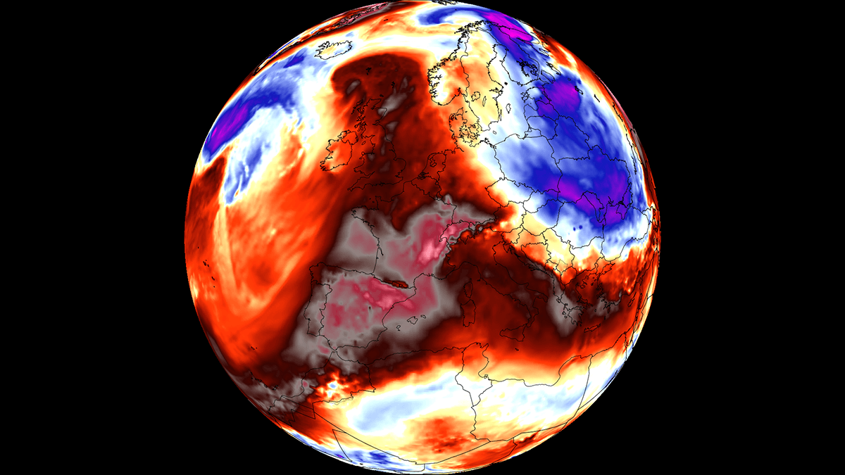
EUROPE — As the calendar turns toward autumn, a formidable and unseasonably intense meteorological phenomenon is gripping the European continent. A powerful early-September "heat dome" is expanding rapidly across Southern Europe and the Mediterranean, setting the stage for a severe, late-season heatwave. Driven by a broad, persistent warm plume surging northwards out of North Africa, surface temperatures are forecast to skyrocket into the upper 30s, with localized readings expected to comfortably exceed 40°C (104°F) across several nations.
Meteorologists warn that this sprawling blocking high-pressure system will create prolonged heat stress, elevate wildfire dangers across parched landscapes, and strain energy grids just as schools and businesses return from the traditional summer holiday period. While the heat is projected to dominate weather patterns for the next week to ten days, long-range ensemble models hint at a dramatic, potentially volatile atmospheric shift by mid-September.
Main Facts: Anatomy of the Early-September Heat Dome
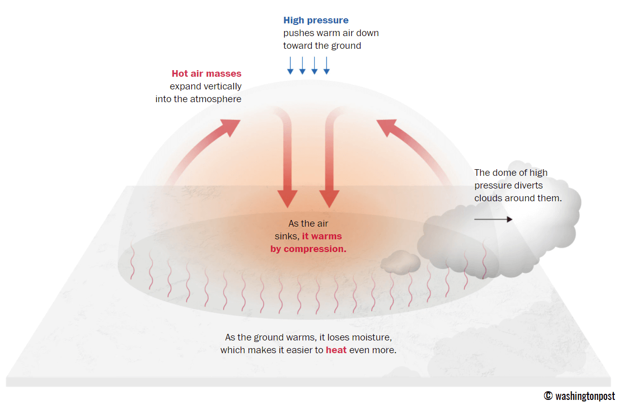
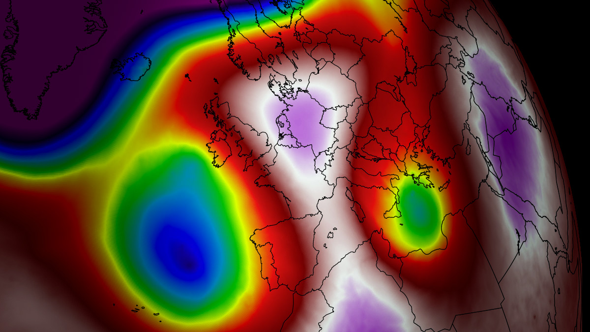
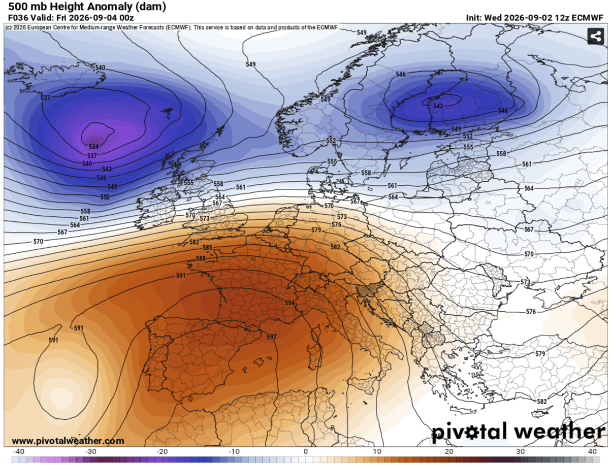
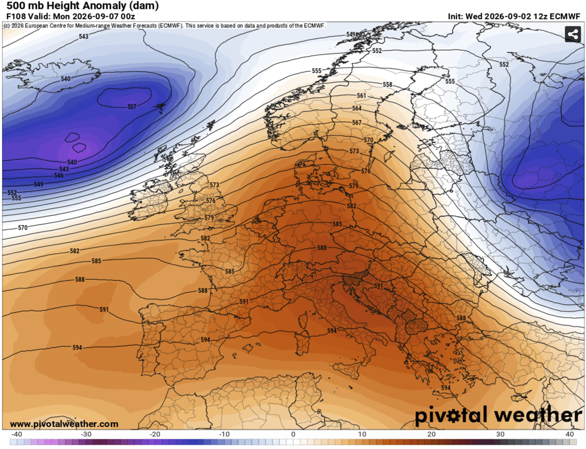
The primary catalyst for this late-summer thermal surge is an expansive high-pressure system parked squarely over the Mediterranean Basin. In meteorology, such a feature acts similarly to a lid on a boiling pot of water.
Atmospheric Dynamics
As sinking air—known as a subsidence inversion—adiabatically compresses and warms within the upper-level ridge, it traps hot air masses at lower elevations. This process rapidly depletes soil moisture and bakes the landscape beneath cloudless skies.
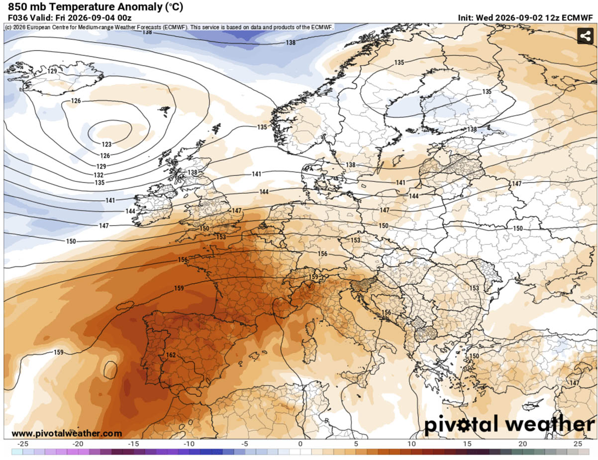
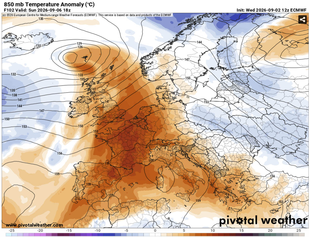
- Temperature Anomalies: Upper-air thermal anomalies are climbing well above seasonal averages. Across low-lying valleys and coastal interiors in Spain, Italy, and the Balkans, peak afternoon temperatures are projected to range from 38°C to 42°C.
- The "Tropical Nights" Crisis: Beyond punishing daytime highs, the heat dome offers minimal nocturnal relief. Even with shorter September daylight hours, overnight minimum temperatures are refusing to drop below 22°C to 25°C in major urban corridors.
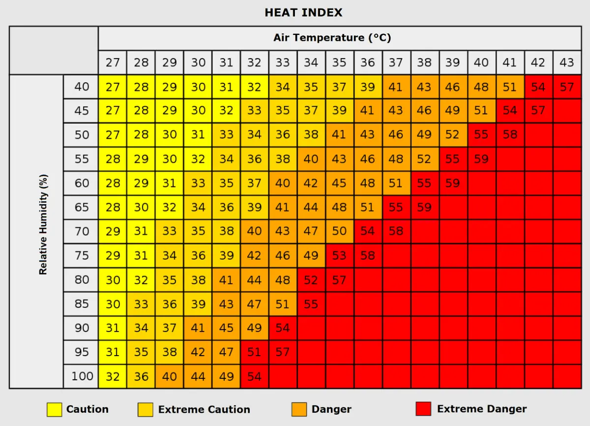
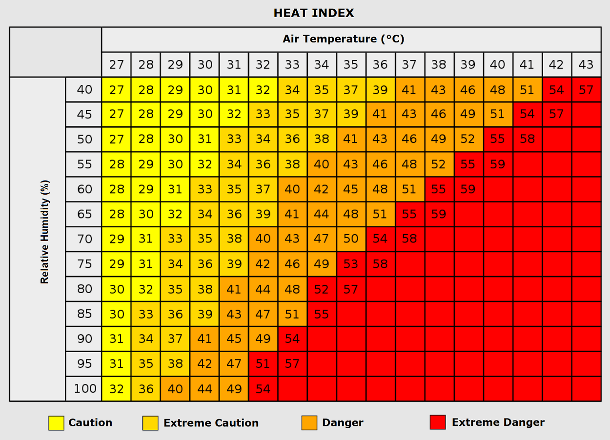
- Physiological Stress: These persistent "tropical nights" deny the human body its vital physiological window to cool down and recover, compounding health risks and elevating the heat index—a metric that combines temperature and relative humidity to measure how hot conditions actually feel to the human body.
Chronology: Evolution of the Continental Heatwave
The establishment and progression of the heat dome follow a distinct, multi-day synoptic timeline moving from the Iberian Peninsula eastward into the heart of Europe.
Phase 1: Southwestern Europe Takes the Brunt (Thursday – Friday)
The intense warm plume established itself firmly over the Iberian Peninsula by mid-week. On Thursday and Friday, peak daytime highs across central and southern Spain and Portugal reached between 40°C and 44°C under an extremely dry continental air mass. Central and northeastern Spain also saw temperatures climb into the upper 30s, flirting with early-September records.
Phase 2: Expansion into France and Western Europe (Through Monday)
As the upper-level ridge expanded aloft, the core of hot air shifted slightly north and east, engulfing most of France. Southern and central parts of France bore the brunt of this phase, with interior southern regions seeing temperatures return to near 40°C. Central France experienced mid-30s heat, while northern France and the Benelux region hovered in the upper 20s.
Concurrently, a secondary, milder warm tongue pushed into the British Isles, driving daytime highs into the mid-to-upper 20s across south-central England and Wales through Sunday, before cooler maritime air moderated the region.
Phase 3: The Mediterranean and Balkan Peak (Friday – Next Wednesday)
From the weekend through the middle of next week, the thermal ridge establishes its stronghold over Italy and the Balkan Peninsula. The Po Valley and Tuscany in Italy, alongside parts of Greece and the central Balkans, are enduring consecutive days of 38°C to 41°C heat.
During this peak phase, 2-meter surface temperatures are tracking a staggering 10°C to 14°C above long-term climate normals for early September.
Supporting Data and Regional Breakdown
Meteorological agencies utilizing data from platforms such as PivotalWeather and WXcharts have broken down the regional extremes expected throughout the duration of the heat dome:
- Iberia (Spain & Portugal): Sustained maximums of 38°C to 44°C. The dry air mass creates extreme fire weather conditions, heavily drying out already stressed vegetation.
- France: Southern and southwestern sectors peaking near 40°C; central regions maintaining mid-30s. Gradual relief is slated to arrive from the west by mid-week.
- Italy & The Balkans: Po Valley and Tuscany facing persistent 38°C–41°C readings. Cities across the central Balkans are observing historic early-September warmth that challenges decades-old climate records.
- The British Isles: A brief, mild surge reaching the mid-to-upper 20s in southern England before giving way to Atlantic-driven weather fronts.
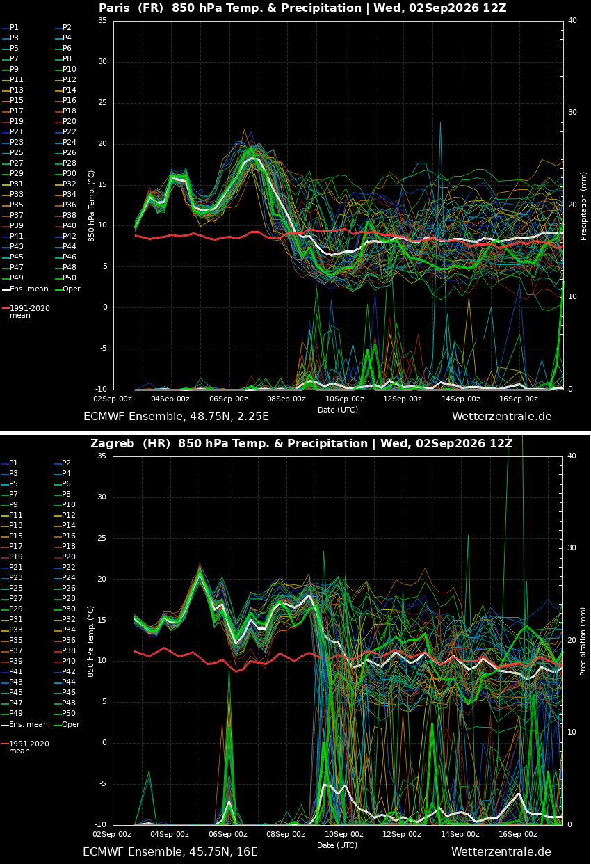
Meteograms for major European capitals, including Paris and Zagreb, underline the longevity of the event, illustrating a stubborn plateau of above-average temperatures before a sharp downward trend is signaled for the following week.
Societal Implications: Health Risks, Infrastructure, and Agriculture
The impacts of a severe heatwave in September—a time when populations traditionally expect a transition to milder autumn conditions—can catch communities off guard. The socio-economic and public health repercussions are widespread:
Public Health Vulnerabilities
Prolonged exposure to excessive heat poses severe dangers, particularly to vulnerable demographics such as the elderly, young children, and individuals with pre-existing cardiovascular or respiratory conditions. Outdoor laborers—including agricultural workers harvesting late-summer crops and construction crews—face heightened risks of dehydration, heat exhaustion, and potentially fatal heatstroke.
Furthermore, urban environments constructed largely of heat-absorbing concrete and asphalt act as urban heat islands, trapping warmth and worsening the physiological toll of tropical nights. Studies associated with prolonged heatwaves consistently note spikes in emergency room admissions, heart attacks, strokes, and respiratory distress.
Energy Grids and Wildfire Hazards
The intense heat drives residential and commercial energy demand significantly higher as cooling systems run continuously, testing the capacity of regional power grids. Simultaneously, the combination of high temperatures, dry continental winds, and depleted soil moisture creates a tinderbox environment. Mountain slopes and forest floors across Southern Europe face an elevated and persistent risk of explosive wildfire growth, complicating containment efforts for emergency services.
Looking Ahead: A Potential Pattern Flip and Severe Weather Risks
Relief, however, appears to be on the horizon. Long-range ensemble weather models indicate a significant synoptic pattern change beginning around mid-week.
An upper-level high-pressure ridge is forecast to build over the North Atlantic, paving the way for a deep, cold-air mass intrusion. This incoming cold wave is projected to punch into Western Europe and sweep eastward across the continent, systematically dismantling the heat dome.
While meteorologists stress that it is too early to pinpoint exact localized impacts, the breakdown of the blocking high is expected to usher in a much cooler maritime air mass. Crucially, this transition could also spark severe weather outbreaks—including heavy, much-needed rainfall—as the cold front collides with the lingering reservoir of residual heat and moisture across Central and Western Europe.
As the continent navigates the final days of this punishing early-September heatwave, national weather services and civil protection agencies remain on high alert, urging residents to heed local heat advisories and monitor evolving forecasts for the impending pattern flip.
