

Main Facts
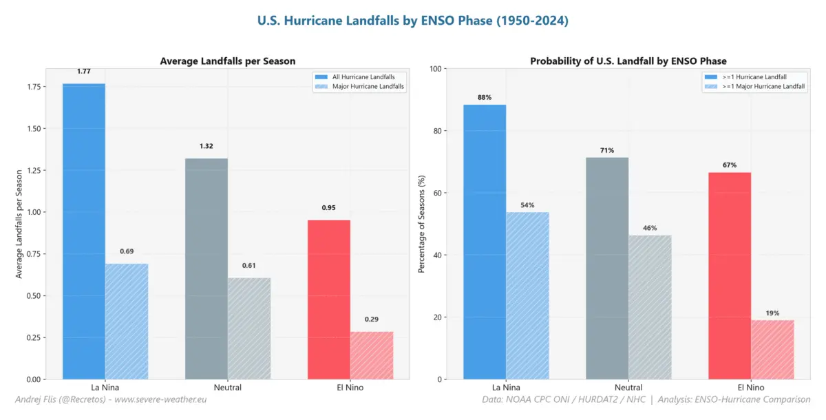
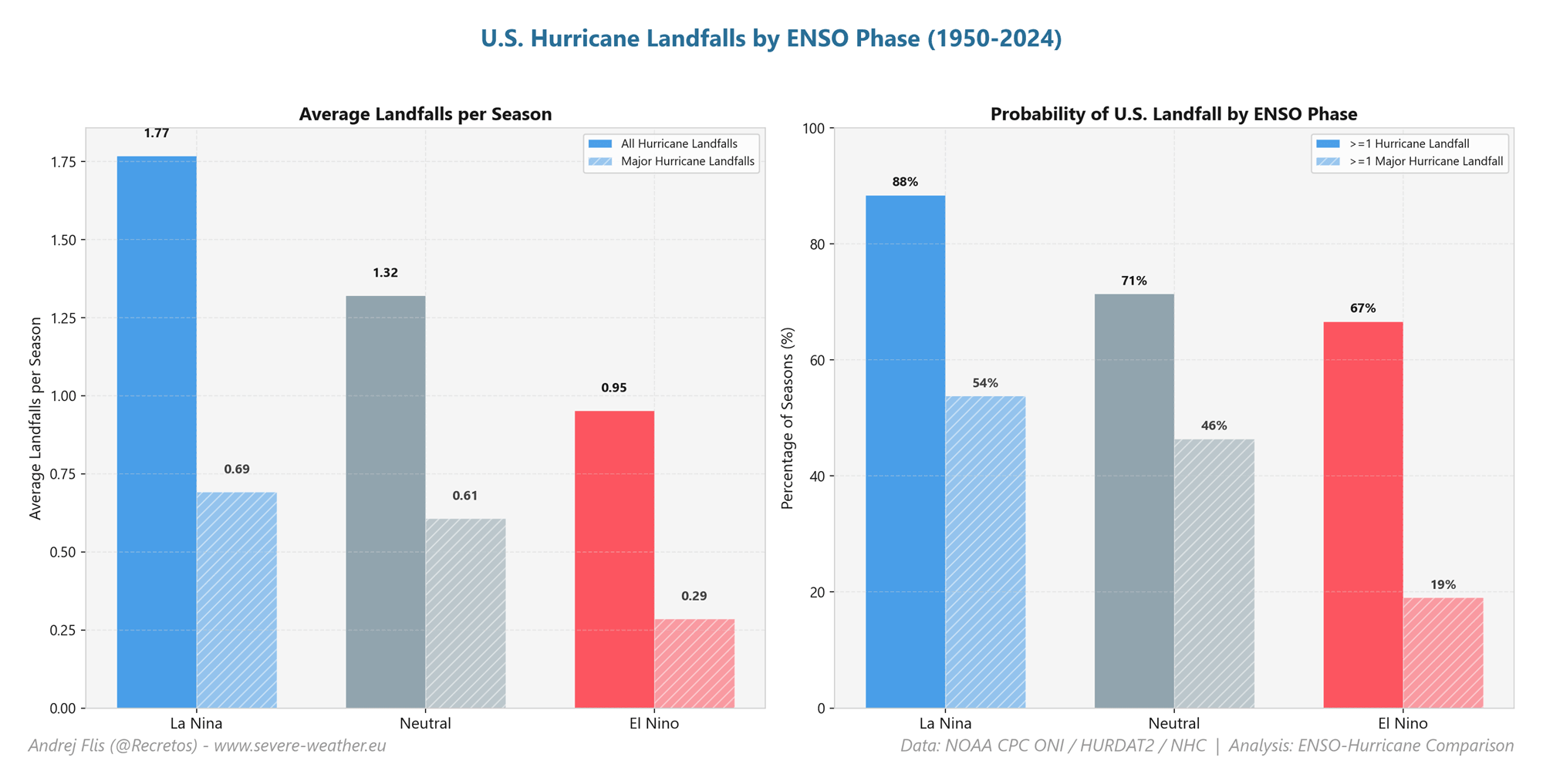
A powerful Super El Niño is rapidly developing across the tropical Pacific Ocean, reshaping global atmospheric circulation and creating what meteorologists describe as an "atmospheric hurricane shield" for the United States. Driven by extreme ocean temperature anomalies exceeding 7°C (12.6°F) above normal in the eastern equatorial Pacific, this planetary-scale event has rendered the 2026 Atlantic hurricane season historically quiet.

Key facts of this meteorological anomaly include:
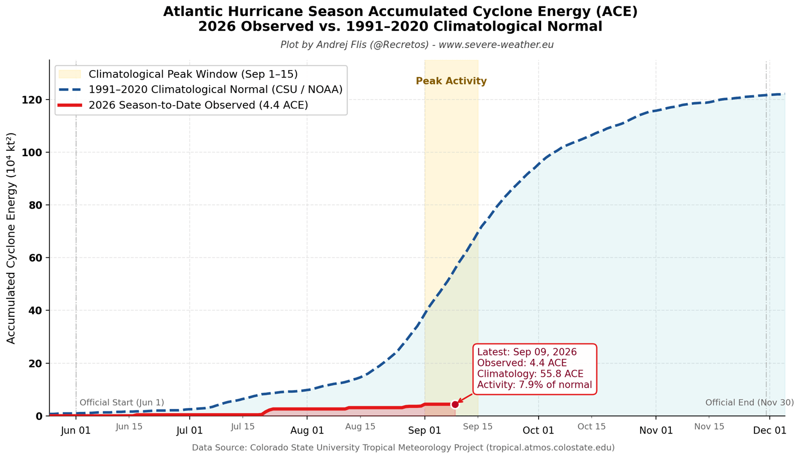
- Suppressed Atlantic Activity: Accumulated Cyclone Energy (ACE) sits at a meager 8% of the historical average for this point in the season, driven by only five short-lived named storms and zero hurricanes.
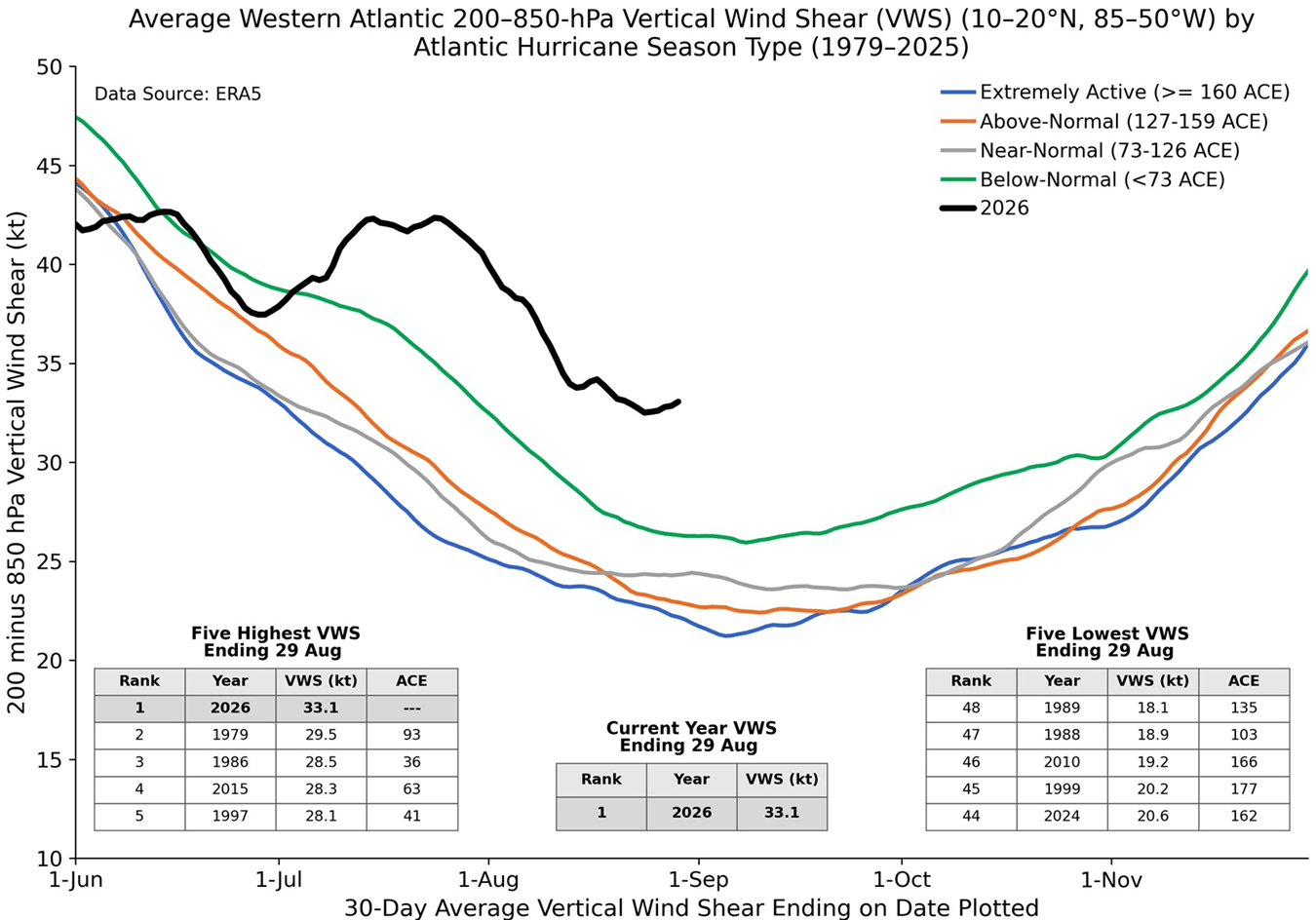
- Record Wind Shear: According to data analyzed by seasonal hurricane expert Dr. Philip Klotzbach, Atlantic vertical wind shear for July and August ranks as the highest in a 47-year observational record.
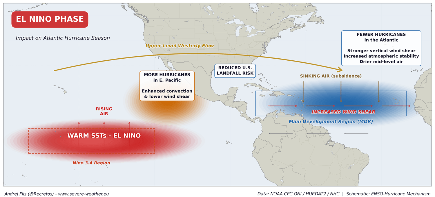
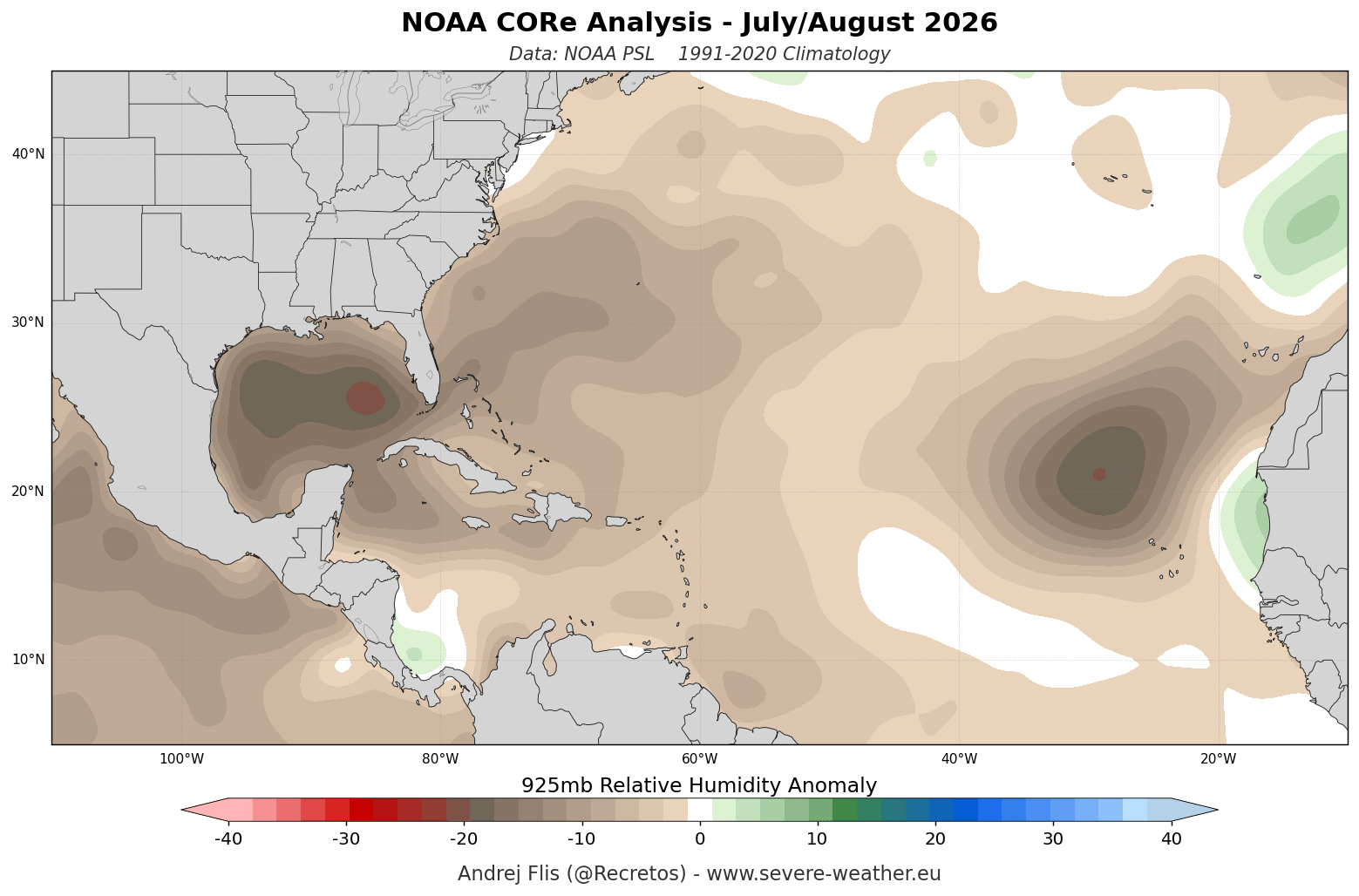
- Severe Drying and Subsidence: Lower-to-mid tropospheric relative humidity across the Main Development Region (MDR) is well below average, producing widespread descending air that starves budding tropical systems of moisture.
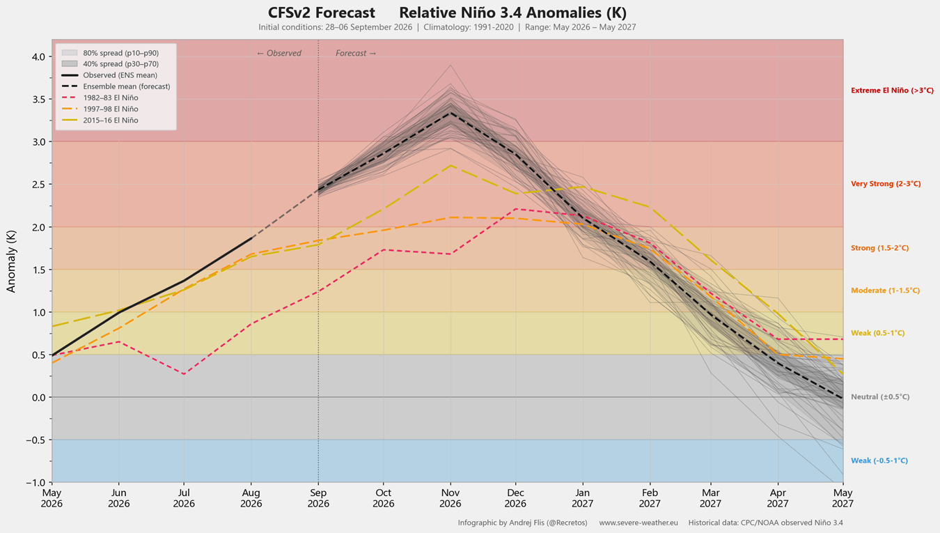
- Super El Niño Status: Sustained seasonal ENSO values have already surpassed the +2.0°C threshold, with long-range climate models projecting this event to eclipse the intensity of the last three major El Niño episodes, potentially ranking as the strongest in over a century.
- Winter Teleconnections: The unprecedented Pacific forcing is already providing early indicators for the upcoming winter, pointing toward a disrupted, weakened Polar Vortex and potential mid-winter cold snaps across the southern and central United States.
Chronology
Early Summer 2026: Subsurface Awakening
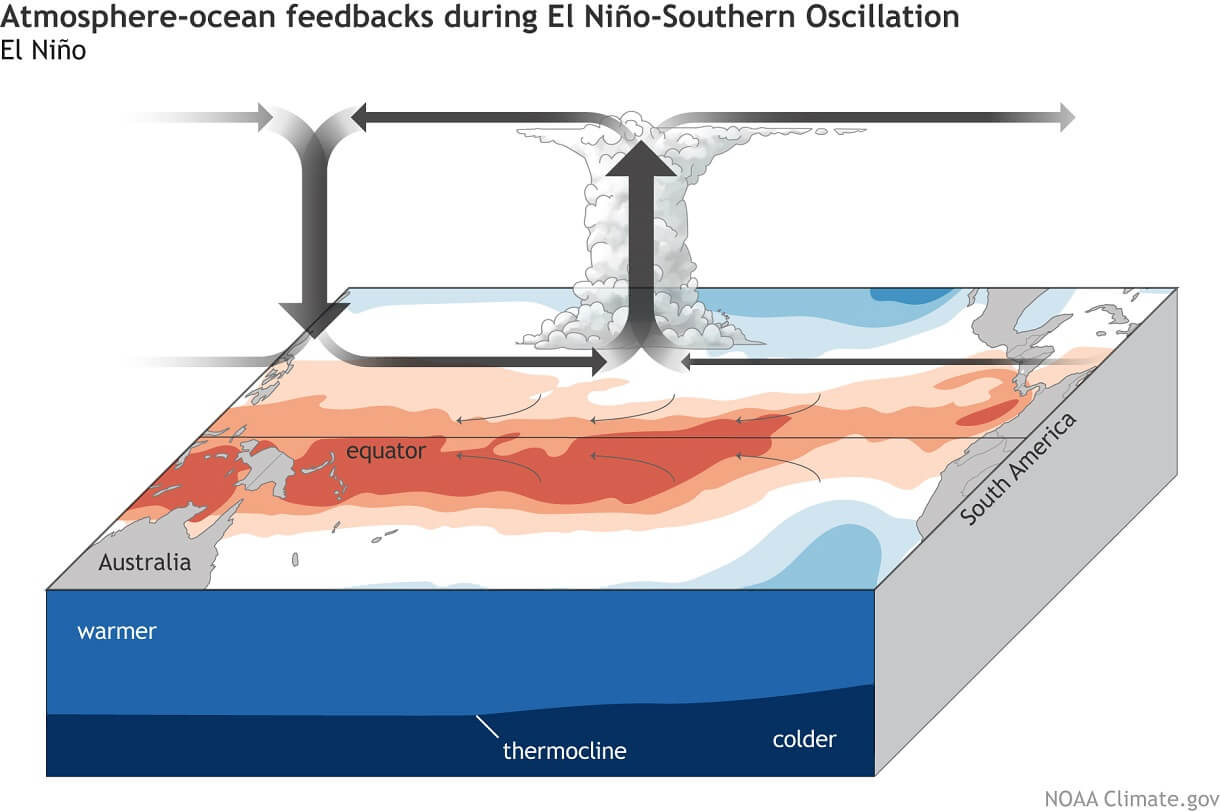
The foundation of the 2026 Super El Niño began deep beneath the ocean surface months before it became apparent at the surface. High-resolution subsurface ocean data revealed the genesis of a powerful Kelvin wave—a massive pool of warm water propagating eastward across the equatorial Pacific basin. As this thermal energy steadily rose toward the surface, it began altering the Walker Circulation, establishing an atmospheric feedback loop characterized by rising air over the central and eastern Pacific and stable, sinking air over the western basin.
July and August 2026: The Shield Activates and the Atlantic Stalls
By mid-summer, the oceanic anomalies translated into dramatic atmospheric consequences across the Northern Hemisphere. As the peak of the Atlantic hurricane season approached, the expected parade of tropical waves rolling off the coast of Africa met an unexpectedly hostile environment.
Rather than finding warm waters and gentle breezes, developing systems encountered record-breaking vertical wind shear. This atmospheric turbulence tilted and tore apart the vertical columns of fledgling storms, permitting dry mid-level air to penetrate their cores. Consequently, the 2026 Atlantic Accumulated Cyclone Energy (ACE) stagnated at roughly 8% of normal climatology, leaving the basin populated only by a handful of weak, short-lived storms that failed to reach hurricane status.
September 2026: Peak Season Suppression
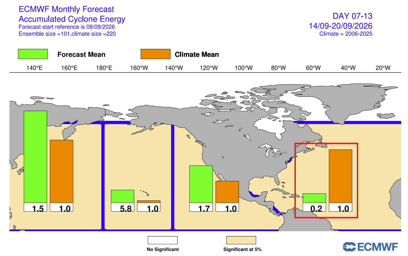
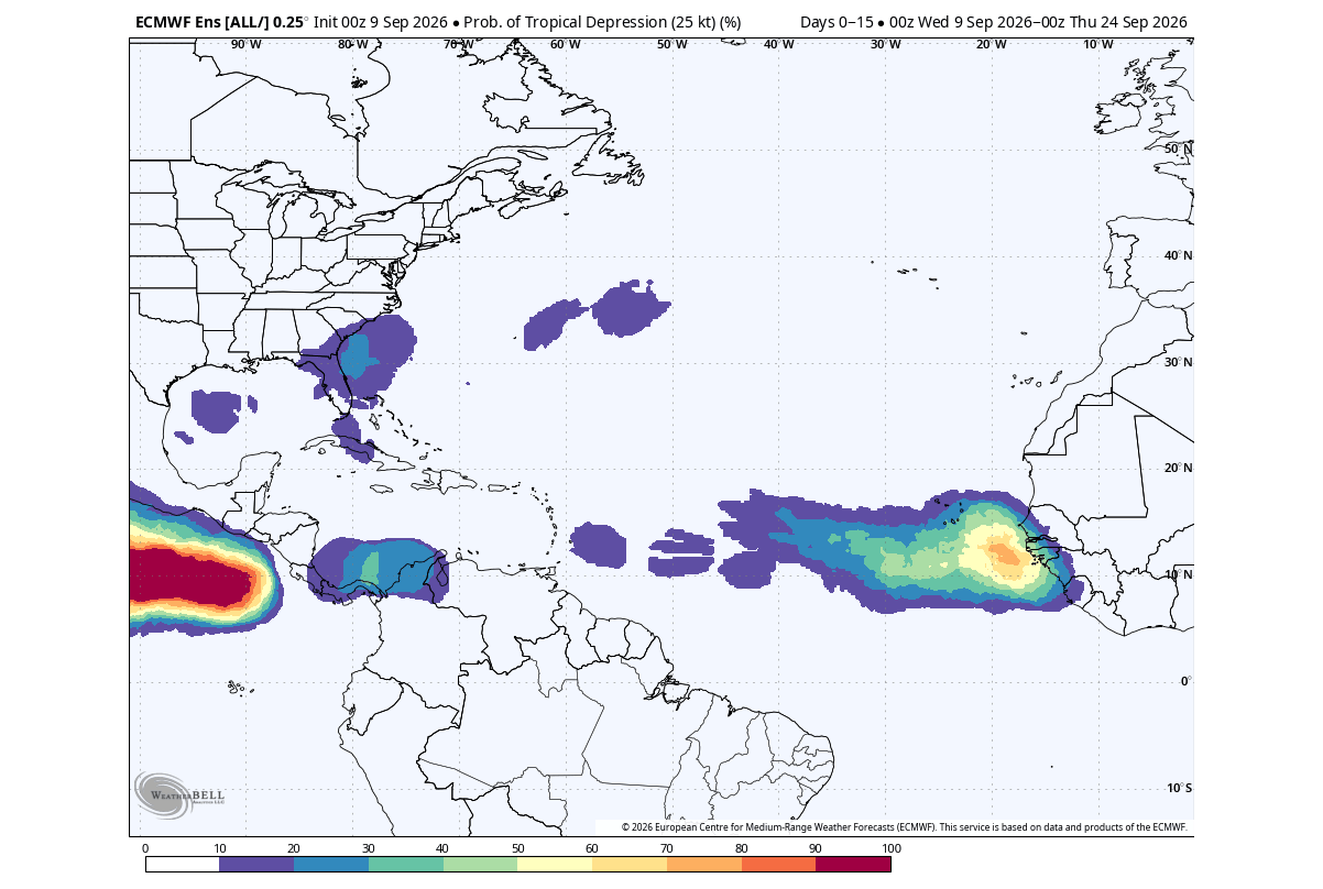
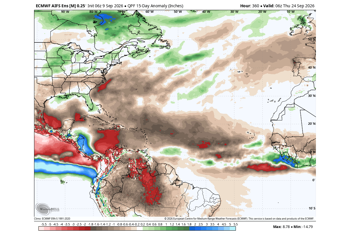
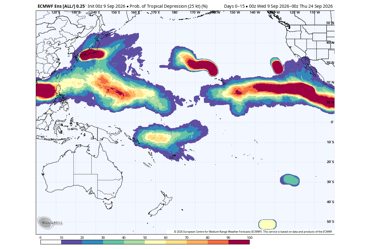
Entering September—the traditional climatological peak of the Atlantic hurricane season—major meteorological models, including the ECMWF (European Centre for Medium-Range Weather Forecasts), confirmed that the Super El Niño was firmly in control. Extended probability forecasts showed a near-total absence of tropical cyclogenesis across the Main Development Region. While the Eastern and Central Pacific experienced robust, El Niño-fueled tropical activity, the Atlantic basin remained locked under high pressure, persistent subsidence, and continuous below-normal precipitation anomalies.
October 2026 (Outlook): A Quiet Twilight to the Season
Long-range seasonal models from the North American Multi-Model Ensemble (NMME) and ECMWF indicate that October will offer no reprieve for Atlantic storm chasers. With core Pacific temperature anomalies forecast to exceed +5°C (+9.0°F), the atmospheric circulation pattern will double down on suppression. A continuous, severe dry signal spans the Caribbean from west to east, ensuring that any late-season development will be strictly localized, brief, and restricted to the northern subtropics or the western Gulf of Mexico.
Supporting Data
The unprecedented nature of the 2026 Super El Niño and its downstream impacts on the Atlantic basin and global circulation are quantified through extensive observational datasets and numerical models:
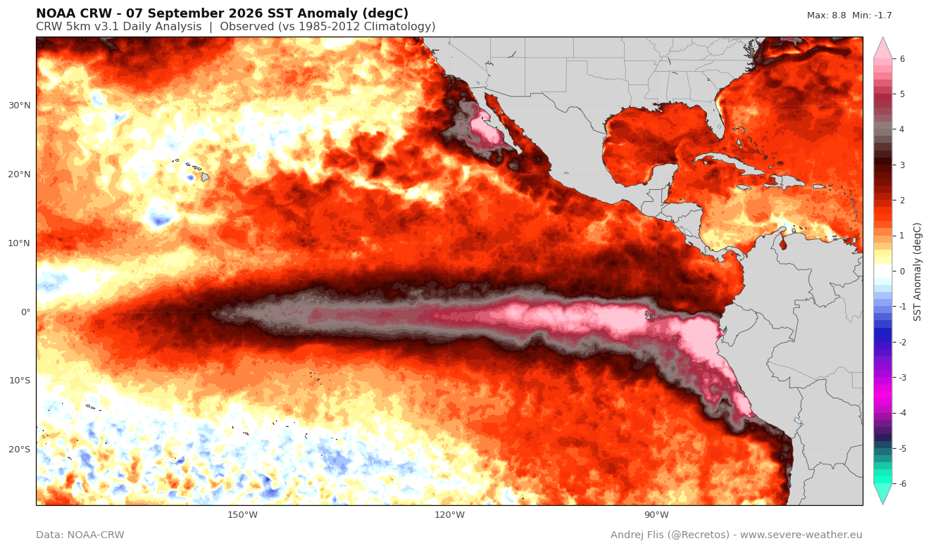
- Ocean Temperature Anomalies (NOAA-CRW): Real-time analysis indicates peak sea surface temperature anomalies in the eastern ENSO region exceeding 7°C above historical baselines, comfortably clearing the threshold required for a "Super" designation.
- Accumulated Cyclone Energy (NOAA/CSU): The 2026 seasonal trajectory displays a dramatic downward departure from the long-term climatological mean. Total energy output is currently anchored by five fleeting named systems, resulting in an ACE index standing at roughly 8% of typical seasonal benchmarks.
- Vertical Wind Shear (Colorado State University): Historical comparisons utilizing data compiled by Dr. Philip Klotzbach show that July–August wind shear across the tropical Atlantic is the strongest recorded in the past 47 years.
- Relative Humidity and Moisture Anomalies (NOAA CORe / ERA5): Gridded atmospheric analyses at the 925mb level (approximately 800 to 2,625 feet) illustrate a vast expanse of negative moisture anomalies blanketing the Main Development Region, inhibiting the deep convection required for hurricane intensification.
- Stratospheric Polar Vortex Projections (ECMWF Ensembles): Long-range ensemble data tracking the 10mb zonal wind anomalies reveal a distinct deceleration and a potential disruption trend beginning in early January 2027, deviating significantly below both the long-term and model-climatological norms.
Official Responses and Meteorological Consensus
Leading meteorological institutions and international forecasting centers have closely monitored the rapid intensification of the Pacific basin and its far-reaching consequences.
The National Oceanic and Atmospheric Administration (NOAA) and the Climate Prediction Center (CPC) have continuously highlighted the robust coupling between the escalating El Niño event and the suppressed tropical Atlantic. Forecasters emphasize that while seasonal outlooks successfully anticipated a shifting baseline, the sheer magnitude of the wind shear and moisture deficits in the tropical Atlantic has exceeded standard historical parameters.
Similarly, the European Centre for Medium-Range Weather Forecasts (ECMWF) has utilized its advanced ensemble systems to brief researchers on the planetary-scale teleconnections at play. Officials note that the atmospheric bridge connecting the tropical Pacific to the North Atlantic and the Arctic stratosphere is operating with textbook precision. While emergency management agencies in coastal U.S. states have found temporary relief from landfalling hurricanes, civil defense planners are being urged to pivot their long-range focus toward the upcoming winter season, where shifting weather patterns may introduce new vulnerabilities.
Implications
Immediate Safety and Economic Relief for Coastal Regions
The most direct implication of the 2026 Super El Niño is the profound reduction in risk for coastal communities along the United States Gulf and Atlantic seaboards. With an effective "atmospheric shield" neutralizing tropical development, billions of dollars in potential property damage, agricultural disruption, and infrastructure loss have been averted. Marine commerce, offshore energy production in the Gulf of Mexico, and coastal tourism have operated largely uninterrupted by major storm threats during the peak autumn months.
Shifting Focus: Winter 2026/2027 and Polar Vortex Disruption
As the tropics wind down earlier than normal, climatologists are turning their attention to the broader implications for the upcoming winter. Historical analogs and current ECMWF seasonal model runs suggest that the same Pacific forcing driving the current quiet hurricane season will mold a distinct winter climate pattern across North America and Europe.
- Temperature Realignments: The southern and central United States are projected to experience a trend toward below-normal mid-to-late winter temperatures, counterbalanced by persistent warmth across much of Canada under a dominant high-pressure ridge. Europe is favored to see a predominantly mild winter.
- Stratospheric Dynamics: Perhaps the most critical long-range implication involves the stratosphere. Ensemble forecasts depicting a decelerating Polar Vortex in January and February 2027 point toward a weakened, potentially disrupted vortex state.
- Cold-Air Outbreaks: A compromised Polar Vortex loses its containment capability, allowing polar air masses to spill out into mid-latitude regions. This dynamical shift increases the probability of high-impact winter weather events, heavy snowfall, and sharp temperature plunges across parts of North America as the winter progresses.
In summary, while the 2026 Super El Niño has provided the United States with an unprecedented and welcome reprieve from Atlantic hurricane landfalls, it simultaneously sets the stage for a volatile winter transition. Researchers and long-range forecasters will continue to track these evolving atmospheric bridges as the global climate system adapts to one of the most powerful Pacific warmings on modern record.
