

As the atmospheric and oceanic gears turn toward the upcoming cold-weather season, initial long-range predictions for the Winter 2026/2027 snowfall pattern point decisively toward a single dominant climatic driver: a rapidly developing, historic Super El Niño.
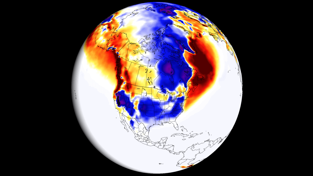
Meteorological data from premier global modeling centers—including the European Centre for Medium-Range Weather Forecasts (ECMWF) and the UK Meteorological Office (UKMO)—reveal pronounced regional extremes across North America and Europe. By fundamentally reshaping the global jet stream and altering low-pressure storm tracks, this monumental oceanic warming event is setting the stage for a winter defined by stark geographic divides: deep powder for some regions, and frustrating snow deficits for others.
Main Facts: The Anatomy of a Historic Super El Niño
To understand where the snow will fall—and where it will likely be missing—meteorologists must first examine the engine driving the global climate system.
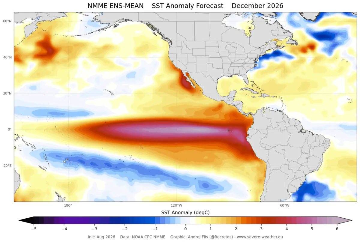
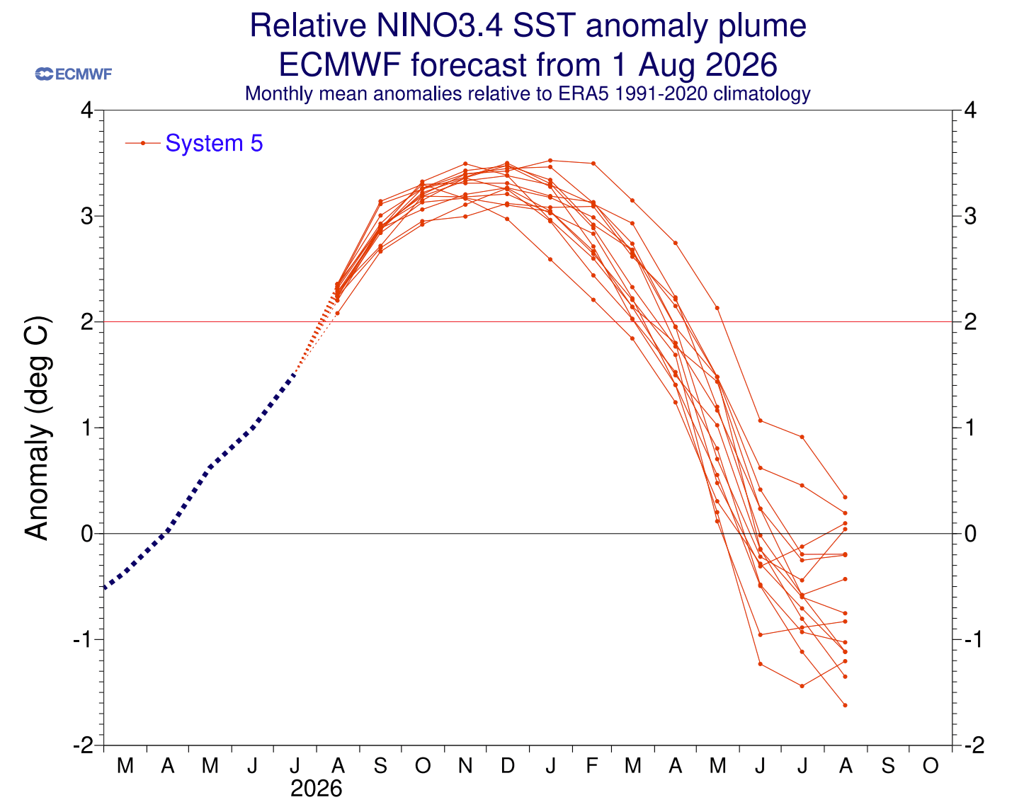
The term “Super El Niño” is not used lightly. It is reserved exclusively for the most extreme equatorial Pacific warming events, defined by sustained seasonal sea-surface temperature anomalies exceeding +2 degrees Celsius. Current observations and forecasts show that the 2026/2027 event has not only crossed this threshold but is projected to peak at anomalies surpassing +3°C, placing it among the strongest events ever recorded.
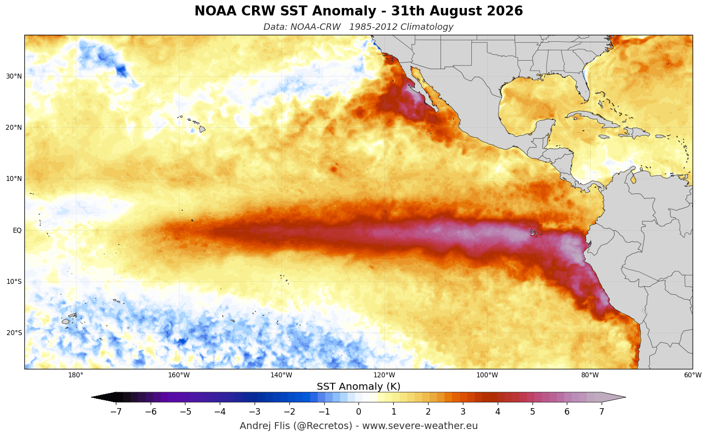
According to data from NOAA’s Coral Reef Watch (CRW), significant warm anomalies have engulfed the tropical Pacific, with peak temperatures soaring more than 6°C (10.8°F) above normal in the eastern basins. Beneath the surface, the ocean’s heart tells an even more dramatic story: a massive downwelling Kelvin Wave—with subsurface temperature anomalies exceeding 10°C (18°F) above normal—is surging eastward through the top 250 meters (800 feet) of the water column.
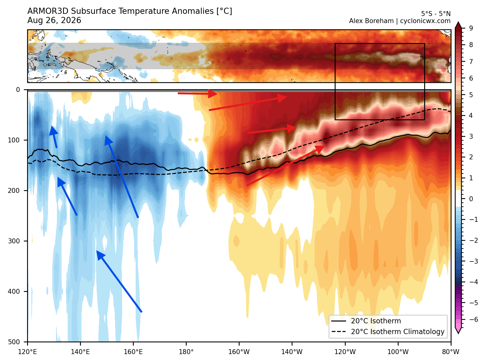
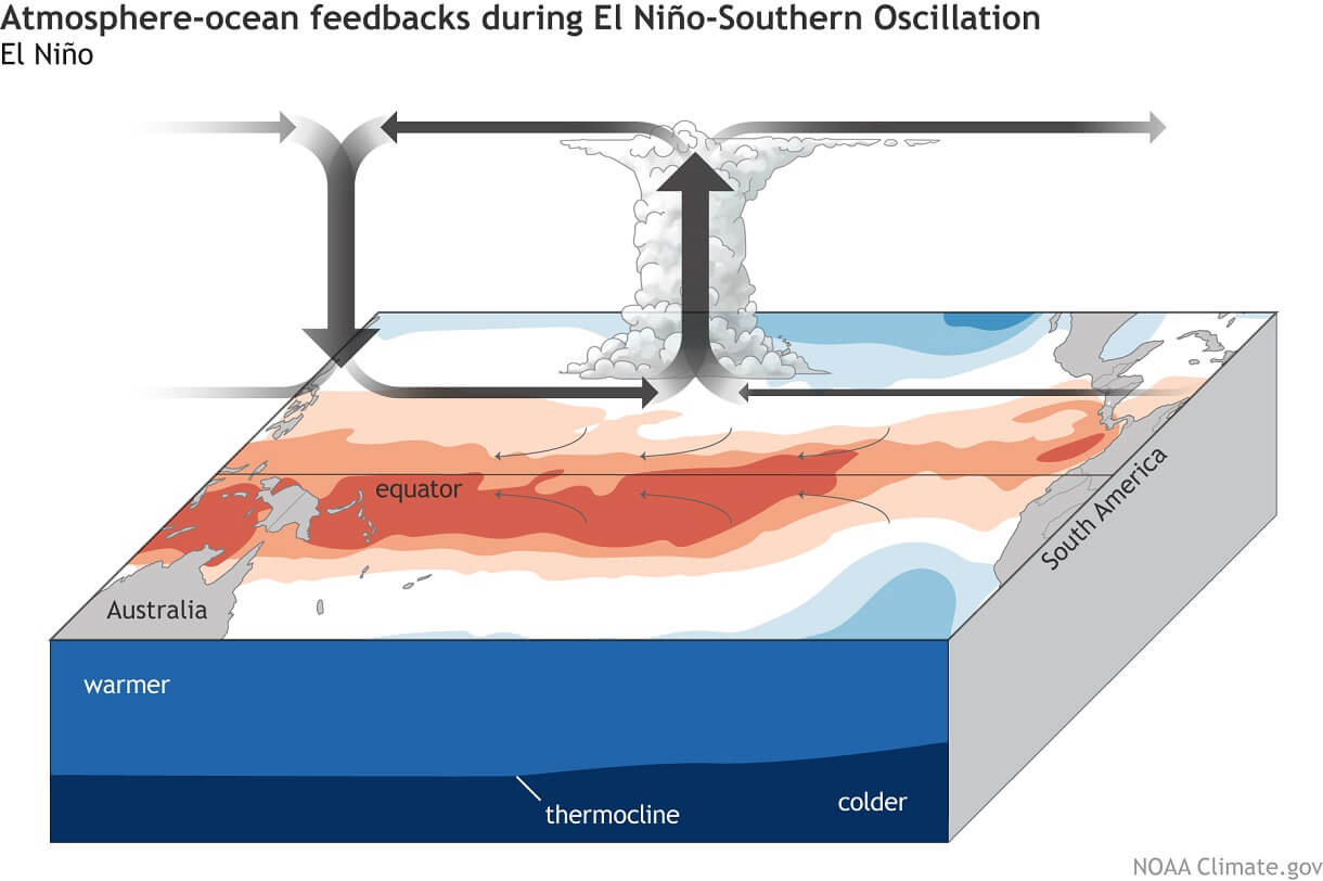
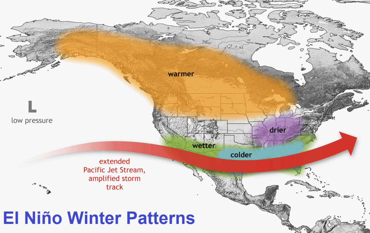
This subsurface wave provides a continuous, stable supply of thermal energy, ensuring that the Super El Niño will remain a formidable force well into the heart of the winter season. The resulting Walker Circulation shifts—rising air and lower pressure over the central and eastern Pacific paired with descending air and high pressure in the west—radiate outward, creating planetary-scale atmospheric bridges that dictate weather patterns from North America to Europe.
Chronology: The Evolution Toward Winter 2026/2027
The progression of this weather pattern follows a distinct timeline, transitioning from oceanic development to atmospheric manifestation and, finally, regional snowfall anomalies.
Summer and Fall 2026: Subsurface Surfacing
During the late summer and early fall months, westerly wind bursts across the tropical Pacific displace warm upper-ocean waters eastward, feeding the massive Kelvin wave. By September and October, these subsurface anomalies connect directly with the surface, establishing the severe eastern Pacific warmth that defines the current Super El Niño phase.
Late Fall 2026: Peak Oceanic Strength
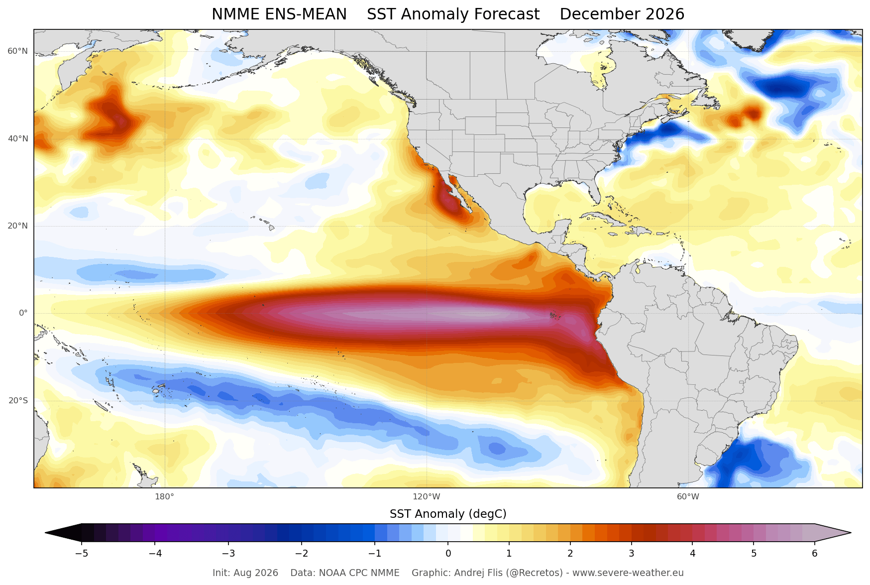
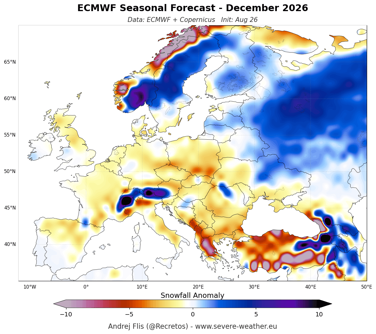
Global forecasting systems, including the ECMWF extended seasonal model and the North American Multi-Model Ensemble (NMME), indicate that the El Niño will reach its absolute peak intensity around December 2026. This maximum oceanic warmth coincides precisely with the onset of meteorological winter, locking in the atmospheric teleconnections that govern storm tracks across the Northern Hemisphere.
Mid-to-Late Winter (January–February 2027): The Jet Stream Takes Over
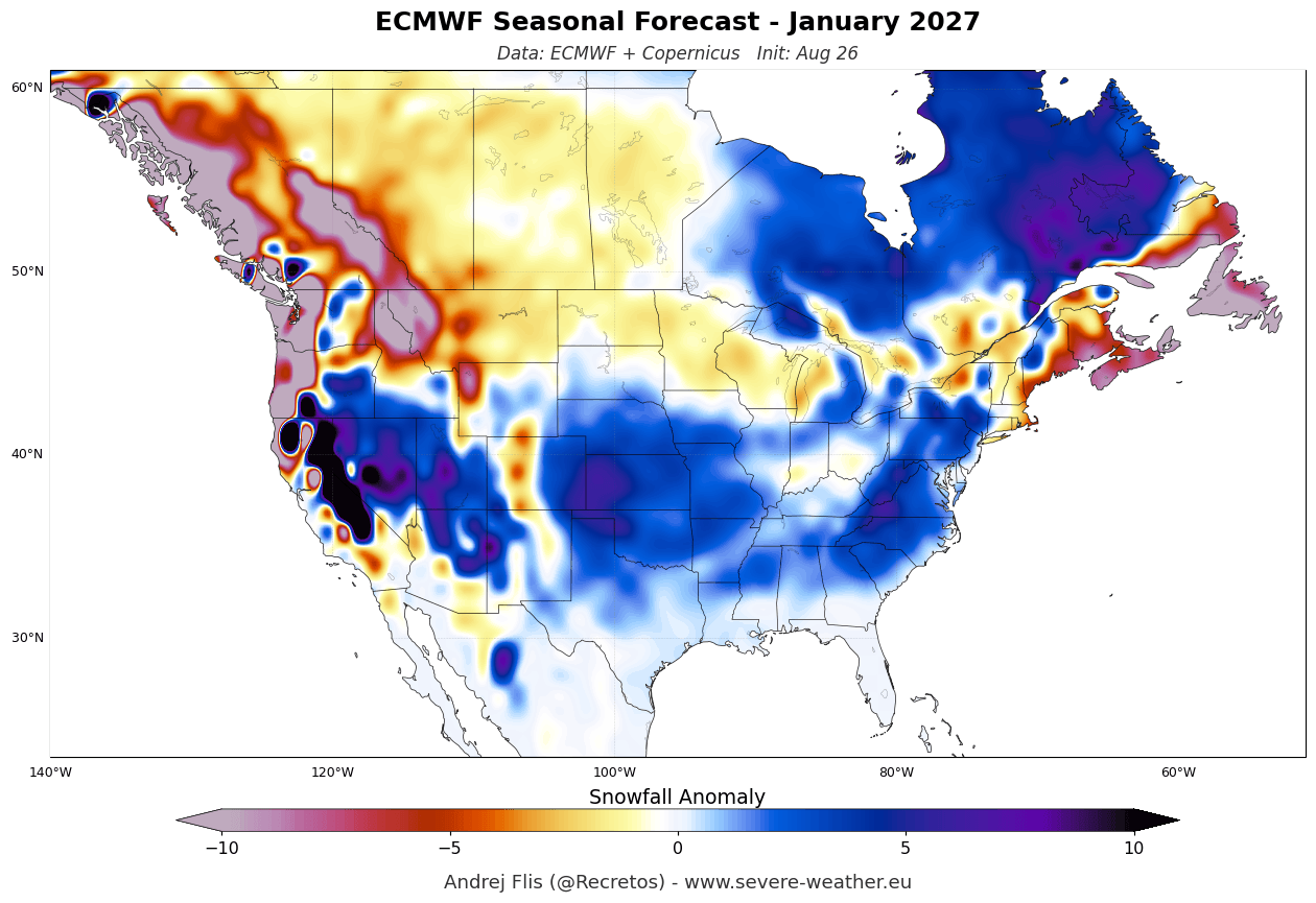
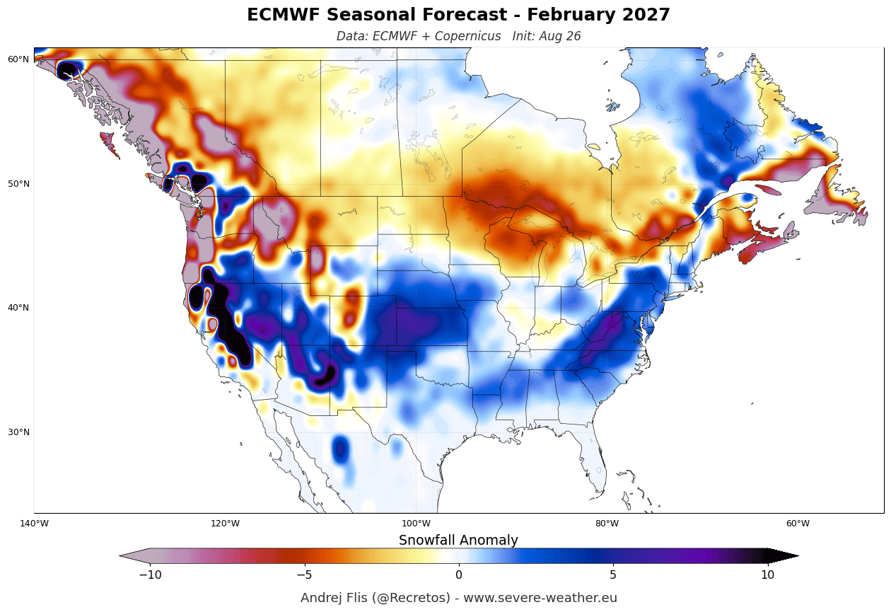
As the winter season progresses into January and February, the atmospheric response matures. The polar jet stream weakens, while the subtropical Pacific jet stream dramatically strengthens and extends its reach across the southern United States. This phase is characterized by dynamic month-to-month variations in storm activity, bringing enhanced moisture and active storm tracks to the southern, central, and eastern U.S., while leaving northern tiers starved of persistent cold and snow.
Supporting Data: ECMWF and UKMO Long-Range Forecasts
Long-range forecasting relies on consensus among independent global models. For the 2026/2027 season, both the ECMWF and the UKMO provide clear, month-by-month breakdowns of expected snowfall anomalies.
North American Snowfall Trends
Over the United States and Canada, the Super El Niño signature is unmistakable. Seasonal composites and ensemble forecasts point to a robust snow regime across specific corridors:
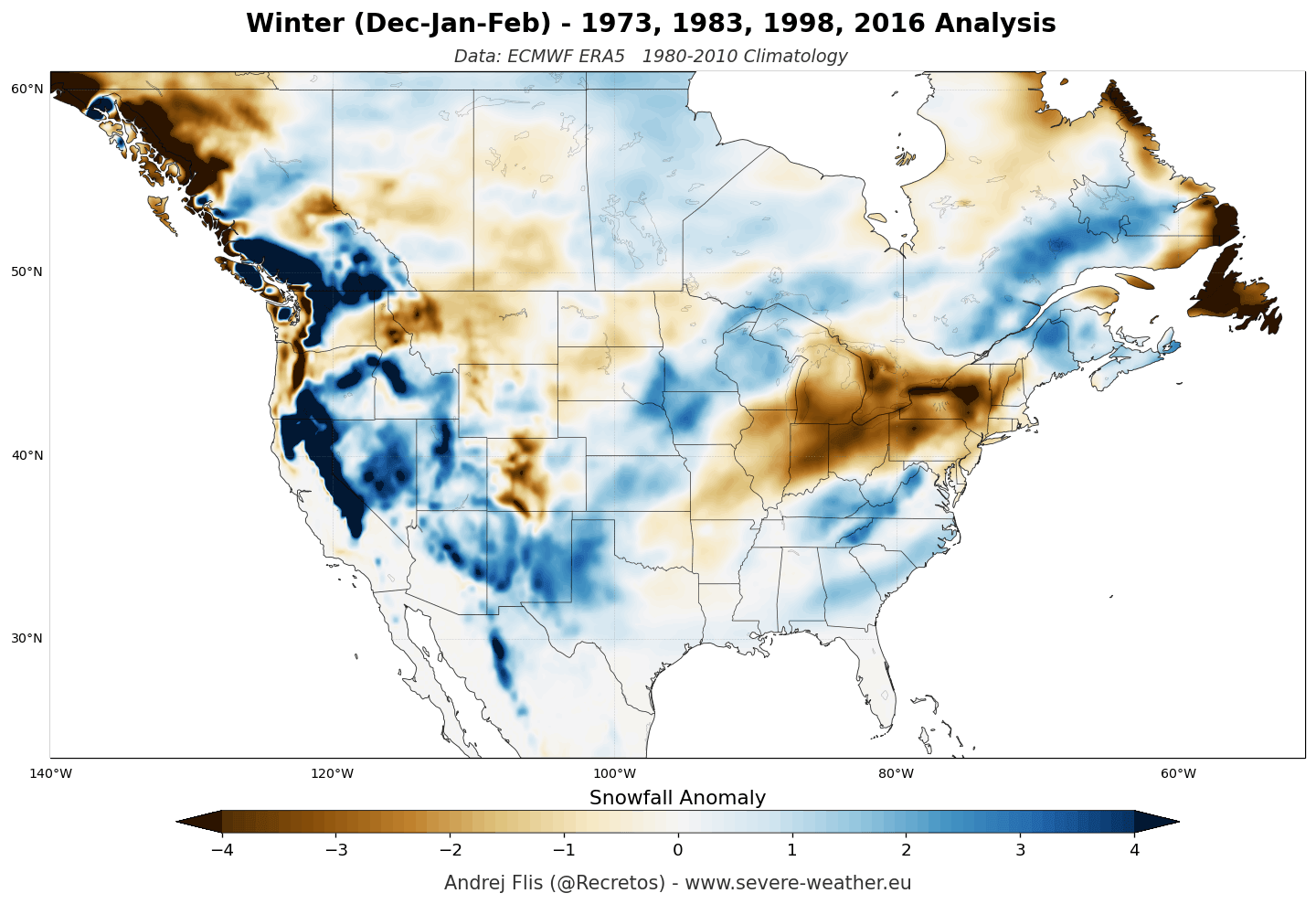
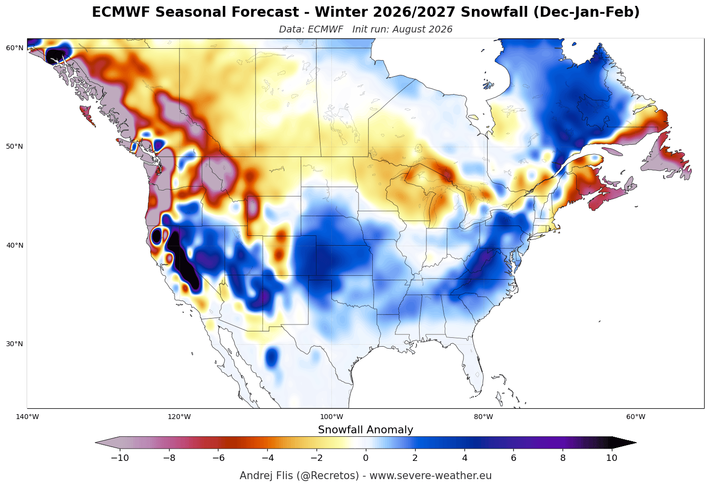
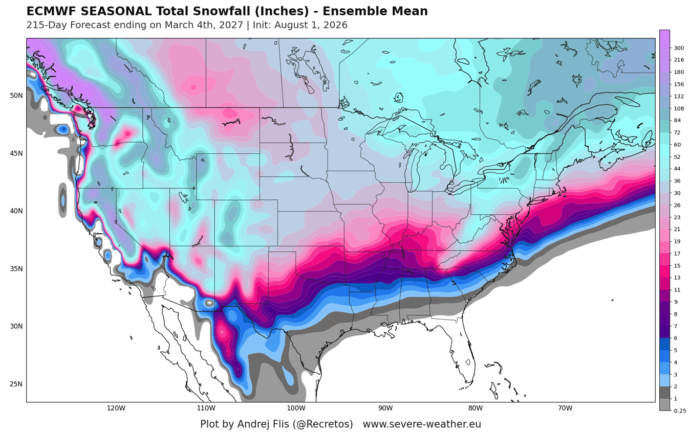
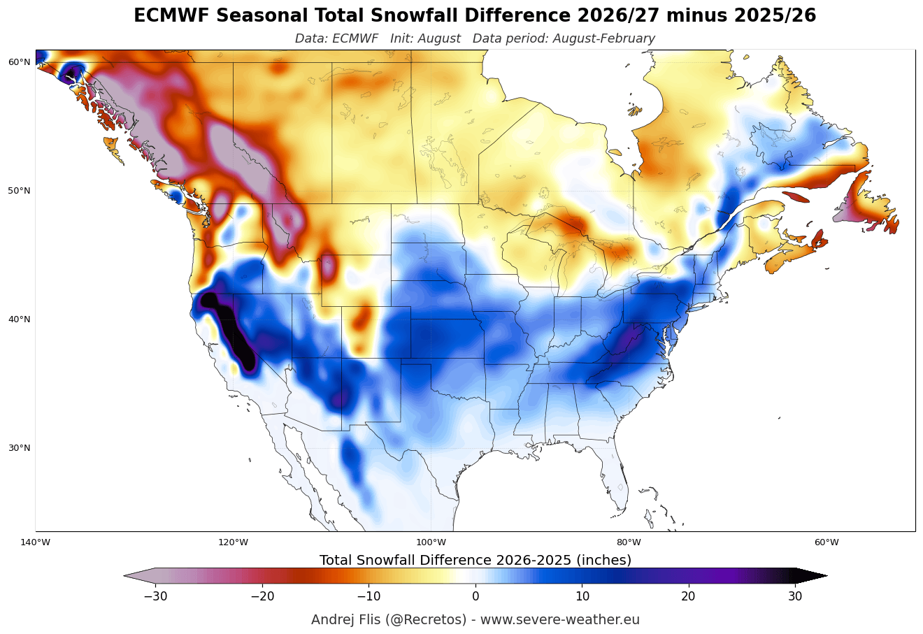
- The American West and Southwest: Skiers and winter enthusiasts in California’s Sierra Nevada, Utah, and the Central-to-Southern Rockies (including Colorado, Arizona, and New Mexico) are favored to receive above-normal snowfall, driven by enhanced moisture riding the southern jet stream.
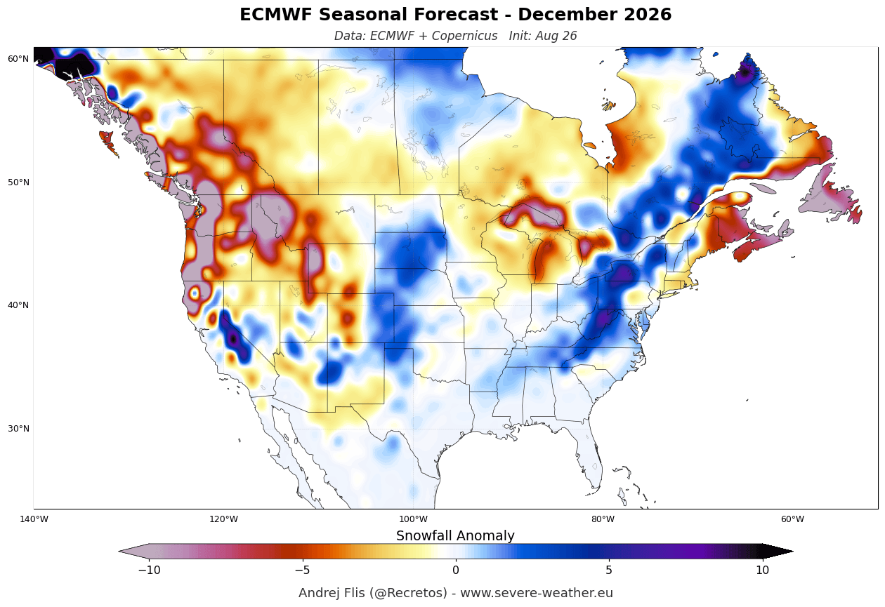
- The Central Plains, Midwest, and Mid-Atlantic: Both December and January forecasts highlight an expanding band of positive snowfall anomalies stretching from the Plains eastward into the Ohio Valley and the Mid-Atlantic. For instance, ensemble data for southern states like Texas indicate a transition from near-normal December conditions to above-normal snow potential by January and February.
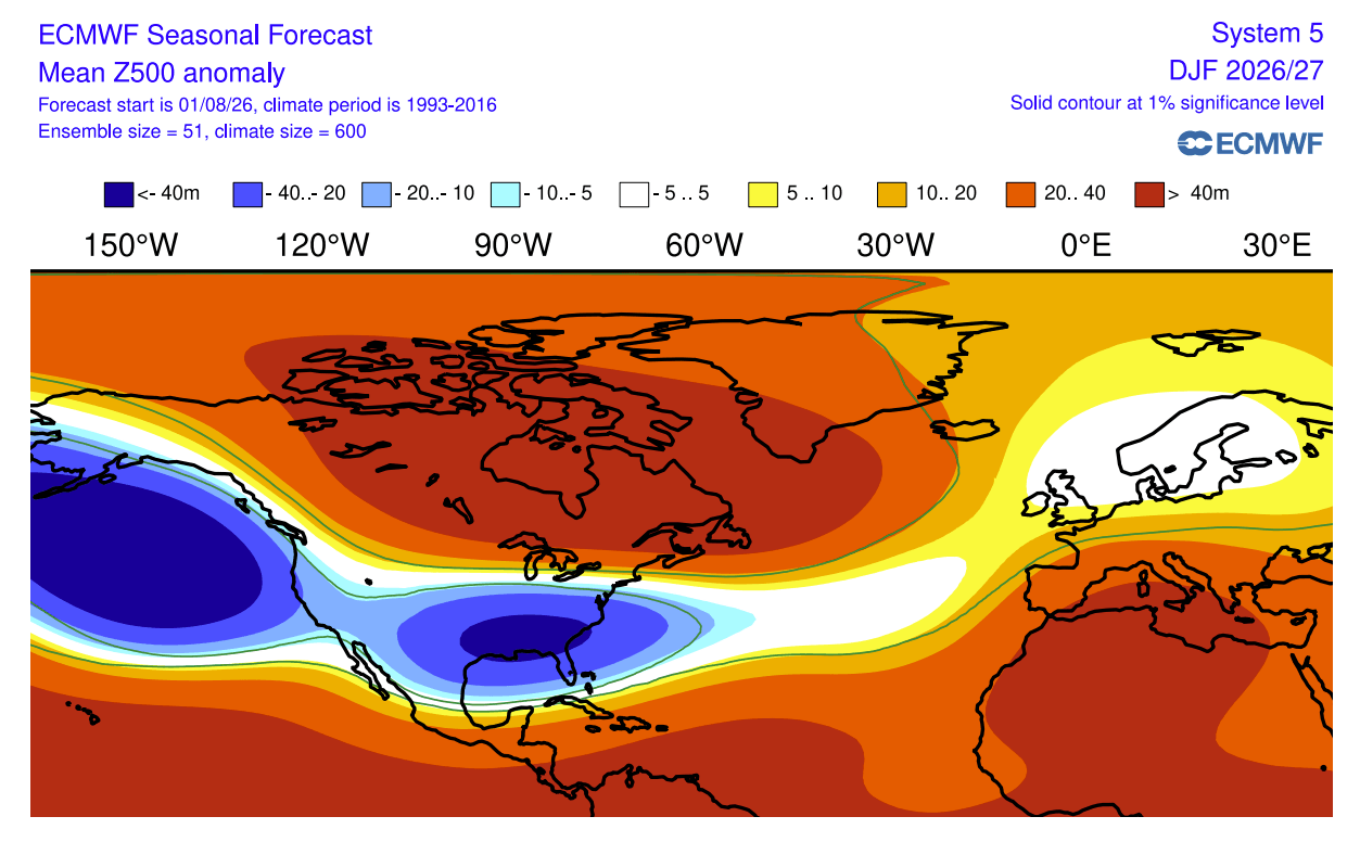
- The Snow Drought Zones: Conversely, significant snowfall deficits are projected across the Pacific Northwest, the northern Plains, the Great Lakes, the Northeast, and the vast majority of southern Canada. Under the influence of a persistent high-pressure ridge over western Canada, northern storm tracks are suppressed, limiting cold air intrusions and starving these regions of sustained snow cover.
European Snowfall Trends
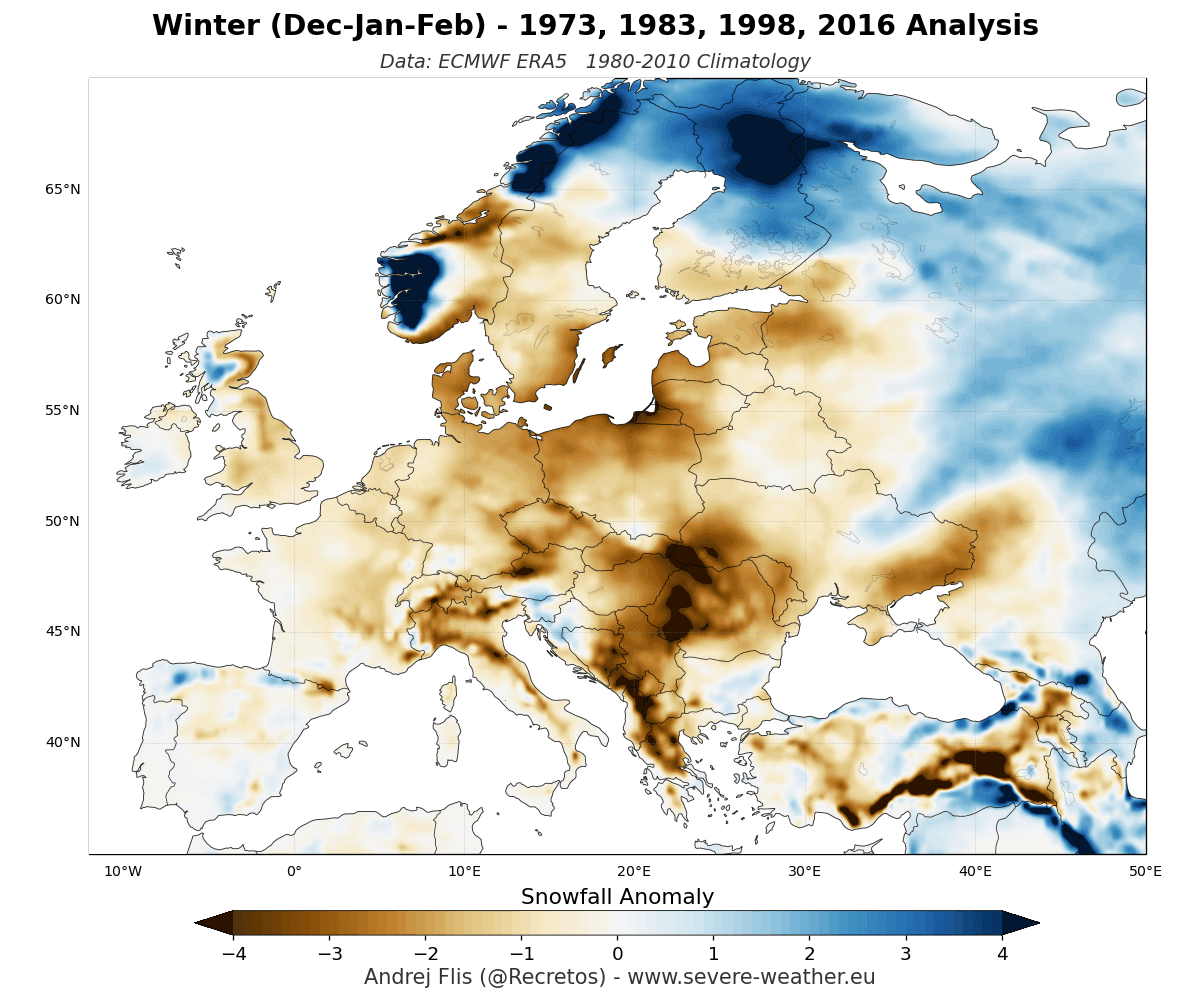
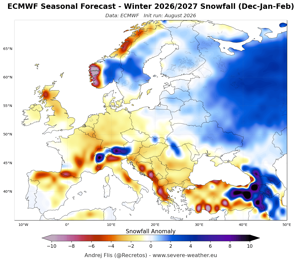
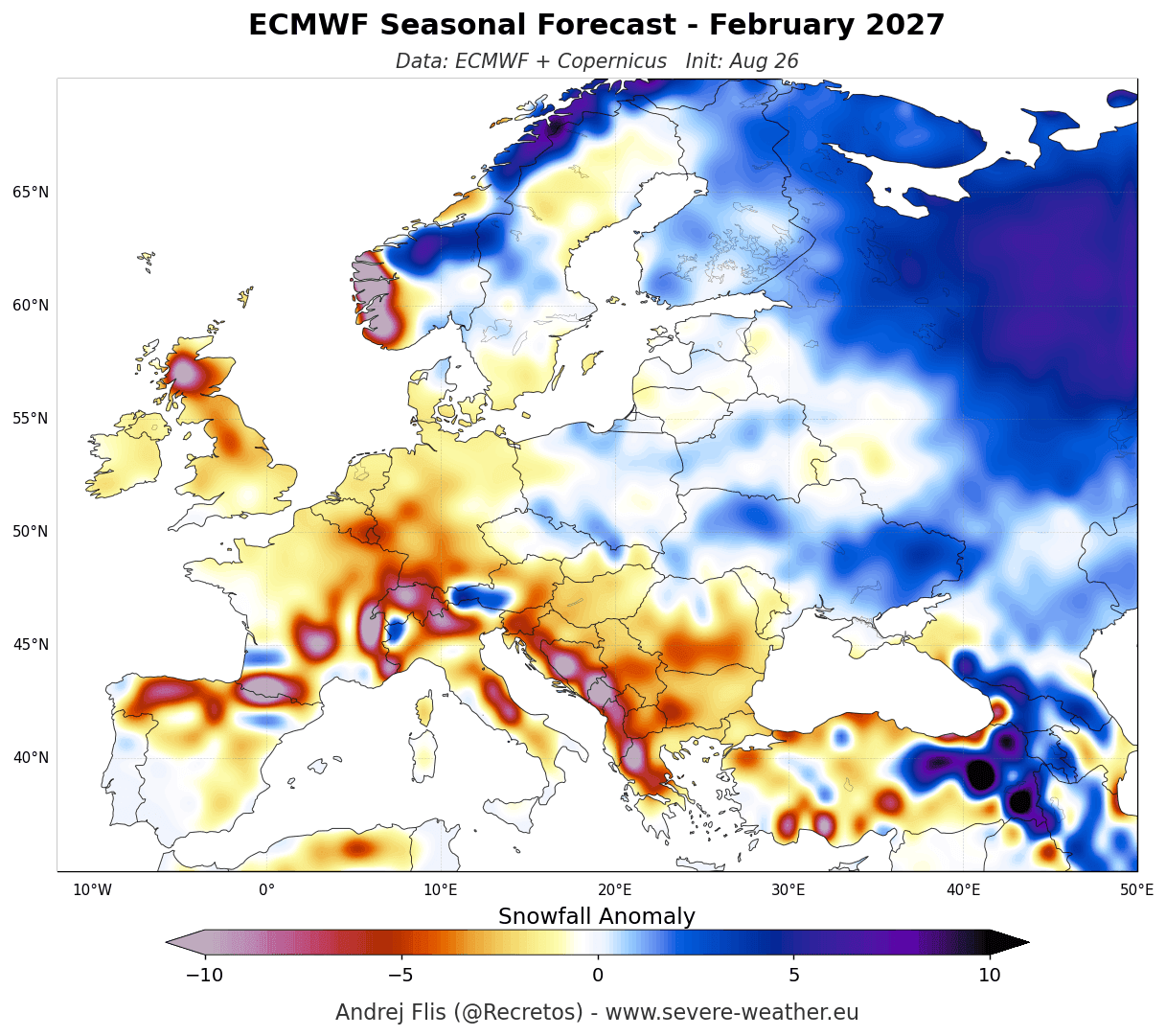
Across the Atlantic, the outlook for Europe leans heavily toward a lean snow season. Both ECMWF and UKMO models project a dominant high-pressure ridge across southern and central Europe, paired with a robust low-pressure zone over the North Atlantic.
This pressure configuration drives a mild westerly to southwesterly flow straight into the continent:
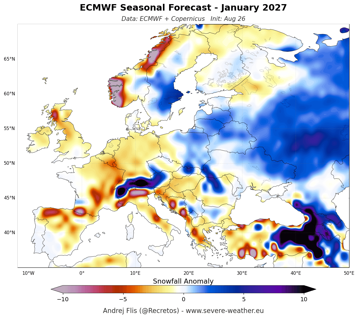
- The Lowlands and Mid-Elevations: Widespread below-normal snowfall is expected across the lowlands of western, central, northwestern, and southern Europe. A delayed start to the season is anticipated, with November and December seeing exceptionally low snow accumulations.
- High-Elevation Havens: Below-normal does not mean a complete absence of snow. High-altitude mountain ranges—specifically the Alps above 1,800 to 2,000 meters—and northern latitudes (such as Scandinavia and the far northeast) retain favorable conditions for establishing a solid natural snowpack, insulating the ski tourism industry at higher elevations.
Official Responses and Analog Studies
Meteorologists validate these cutting-edge computer models by comparing them against historical analogs of past Super El Niño events—specifically looking at winters such as 1982/1983 and 1997/1998.
Historical reanalysis data (ERA5) from past super-events confirms that an amplified southern jet stream systematically increases precipitation across the southern and central tiers of the U.S. while inhibiting northern snow accumulations. Landmark climatological research, including studies by Kunkel and Angel (1999), underscores how strong El Niño events reliably shift winter cyclone tracks southward, reducing snow in the Upper Midwest and Great Lakes while boosting moisture in the Southwest.
Furthermore, additional research into East Coast storm dynamics during warm ENSO phases (such as a notable 2011 synthesis on coastal cyclogenesis) indicates that while northern New England may experience deficits, regions stretching from the Appalachians into the northern Mid-Atlantic can experience potent, high-impact winter storms when phasing occurs correctly between the southern jet and intermittent cold air drops.
Implications: Economic, Environmental, and Practical Impacts
The projected divergence in snowfall patterns for Winter 2026/2027 carries far-reaching implications across multiple sectors:
1. The Ski and Tourism Industry
The economic bifurcation for winter tourism will be stark. Resorts in the Sierra Nevada, Utah, and the Southern Rockies can prepare for robust visitor turnout and healthy snowpacks. Conversely, ski operators in the Pacific Northwest, the Midwest, and European lower-elevation resorts will likely need to lean heavily on snowmaking infrastructure to compensate for persistent thermal and precipitation deficits.
2. Water Resource Management
In the western United States, snowpack acts as a natural reservoir, slowly releasing water during the spring and summer months. Above-average snow accumulation in the Southern Rockies and Sierra Nevada provides a critical boost to regional water security, alleviating drought pressures that frequently plague these watersheds. Meanwhile, northern basins may face early-season melt and lower spring runoff volumes.
3. Transportation and Infrastructure
Municipalities across the central and eastern United States must prepare for an active mid-to-late winter season. As storm tracks dip southward and interact with cold continental air masses, cities from the Central Plains through the Mid-Atlantic could face disruptive ice and heavy snowfall events, requiring proactive readiness from departments of transportation.
As the 2026/2027 winter season draws closer, continuous monitoring of the decaying or strengthening phases of this historic Super El Niño will remain essential. Stakeholders across North America and Europe are advised to stay tuned to ongoing seasonal updates as the atmosphere responds to the largest thermal anomaly in decades.
