

Europe — A formidable and unseasonably intense heat dome has expanded aggressively across the European continent, bringing a punishing late-summer heatwave that is sending surface temperatures soaring into the upper 30s and locally exceeding 40°C. Driven by a broad, persistent warm plume surging north from the North African desert, upper-air thermal anomalies are climbing well above seasonal averages, setting the stage for extreme, record-challenging weather across Spain, France, Italy, and the Balkan Peninsula.
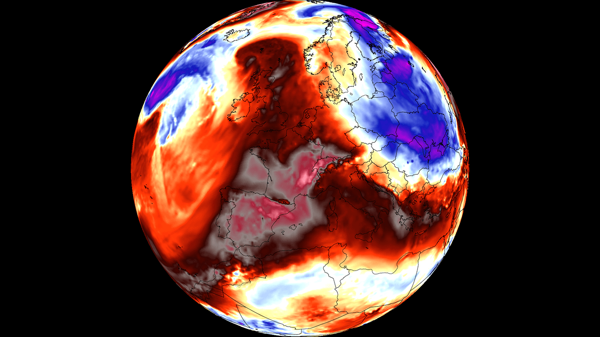
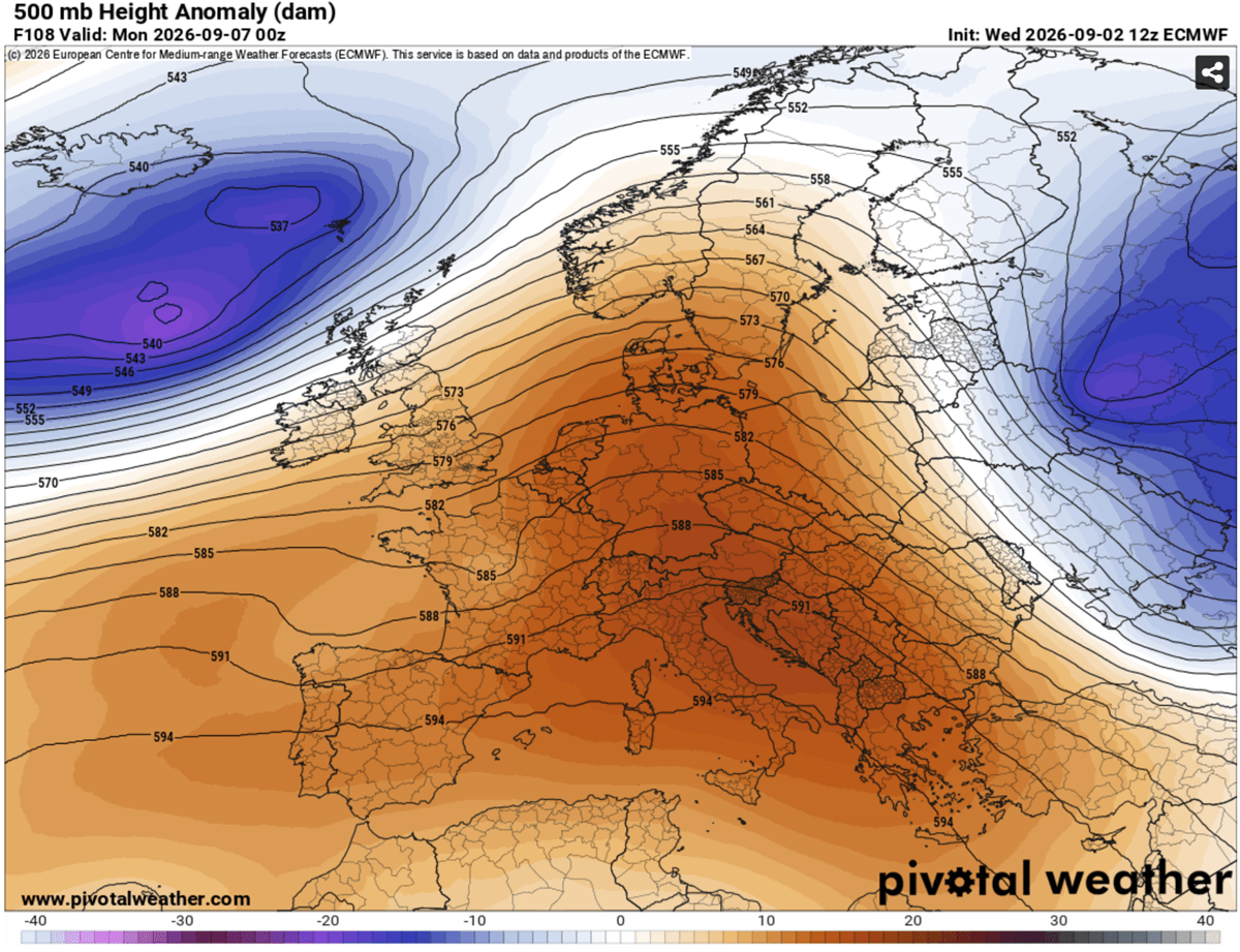
As meteorologists monitor the unfolding crisis, the overarching atmospheric architecture points to a classic, highly stable blocking high-pressure system parked squarely over the Mediterranean Basin. While summer heatwaves are typical for the region, the timing, intensity, and geographical footprint of this early-September event underscore a growing trend of prolonged, high-impact thermal extremes well past the climatological peak of summer.
Main Facts: The Anatomy of the European Heat Dome
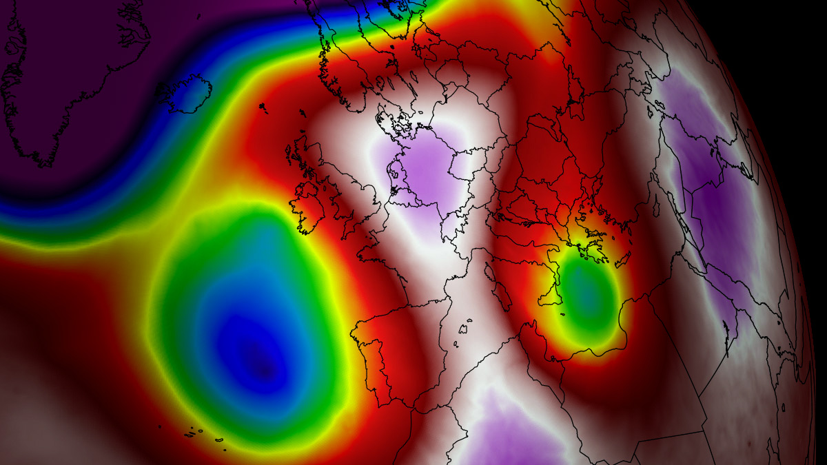
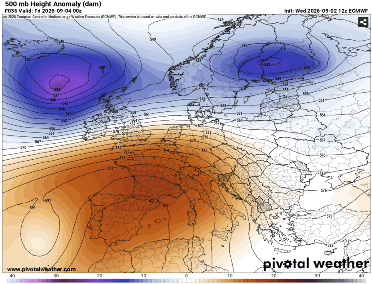
At the heart of this weather anomaly is an expansive upper-level ridge—colloquially and scientifically referred to as a "heat dome." The mechanics of this phenomenon are both simple and severe: a broad area of high-pressure air settles over a vast portion of the continent, acting much like a lid on a pot.
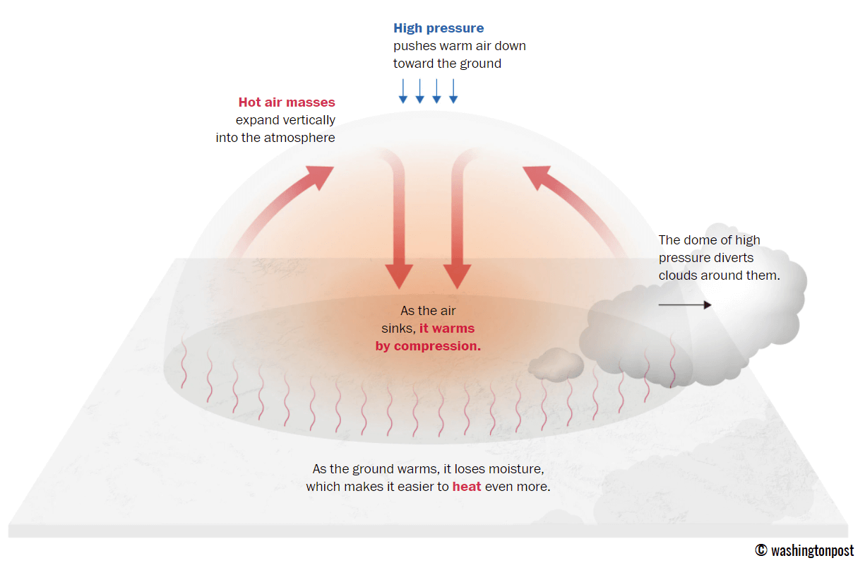
Within this atmospheric trap, sinking air undergoes adiabatic compression, warming the lower atmosphere and forcing extremely hot air masses toward the surface. Dry continental winds accelerate the compression process while rapidly depleting vital soil moisture.
Key Meteorological Highlights:
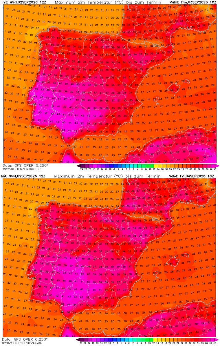
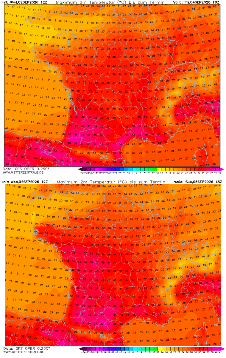
- Temperature Extremes: Low-lying valleys and coastal interiors across Spain, southern France, and Italy are registering peak afternoon temperatures ranging from 38°C to 42°C, with localized pockets in the Iberian Peninsula touching 44°C.
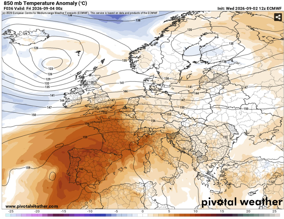
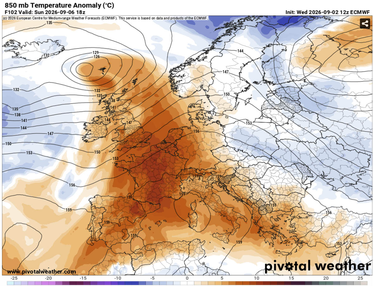
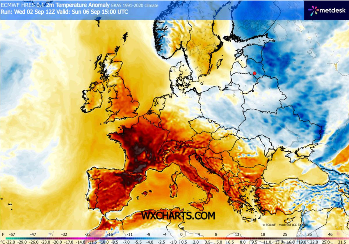
- Thermal Anomalies: Surface temperatures across large swathes of Southern and Central Europe are running 10°C to 14°C above long-term climate norms for early September.
- The "Tropical Nights" Crisis: Perhaps the most hazardous facet of the heat dome is the lack of nocturnal relief. Major urban corridors are recording overnight lows refusing to drop below 22°C to 25°C (and locally higher), denying human bodies the critical physiological window needed to cool down.
- Geographical Reach: While the core of the heat dome focuses on southwestern and southern Europe, its expansive upper-level ridge is projecting warmth northward into the UK, France, Central Europe, and the Balkans.
Chronology: Progression and Evolution of the Heatwave
The establishment and expansion of the heat dome follow a distinct, multi-day synoptic progression across the European continent.
Phase 1: The North African Surge (Mid-Week)
The setup began as a deep warm plume forced its way out of North Africa, driven by a strengthening upper-level high over the western Mediterranean. By Thursday and Friday, this intense thermal surge locked onto the Iberian Peninsula and southwestern France. Central and southern Spain bore the brunt of the initial spike, with temperatures aggressively pushing into the 40–44°C range under bone-dry atmospheric conditions.
Phase 2: Expansion into Central and Southern Europe (The Weekend)
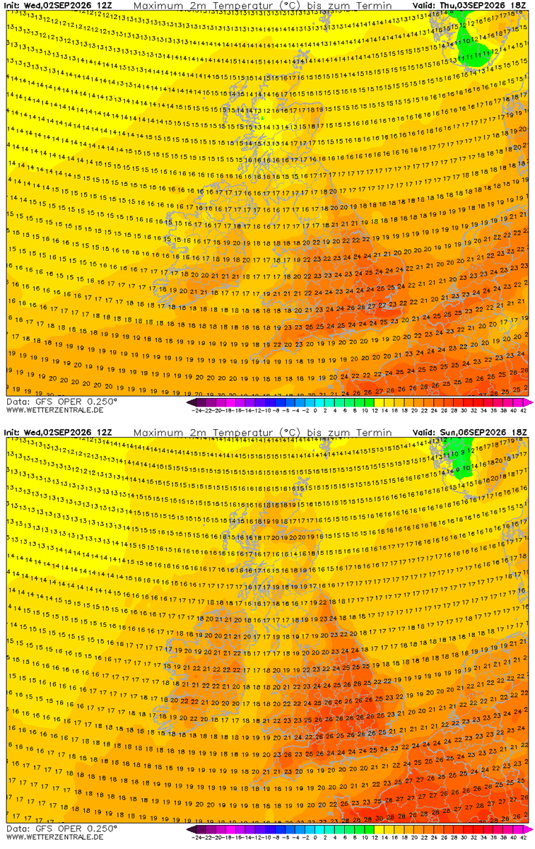
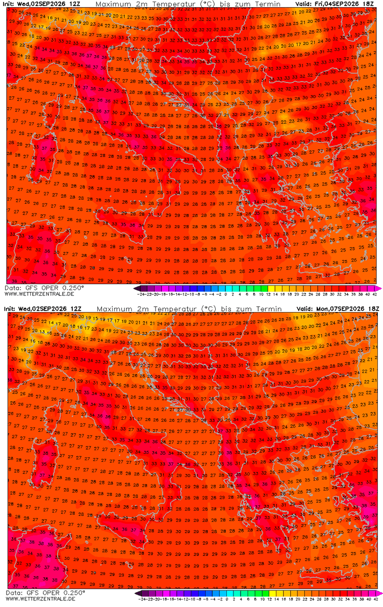
Over the weekend, the blocking high-pressure system shifted and expanded north and east. While a deep low-pressure wave over the North Atlantic initially kept the British Isles relatively temperate (though still seeing mid-to-upper 20s in south-central England), the ridge’s eastern expansion brought a stable, dry air mass over Italy and the central Balkans. Daytime highs in the Po Valley of northern Italy, Tuscany, and parts of Greece surged into the 38–41°C range, threatening long-standing historical records for the first third of September.
Phase 3: Peak Intensity and the Coming Pattern Flip (Early to Mid-Next Week)
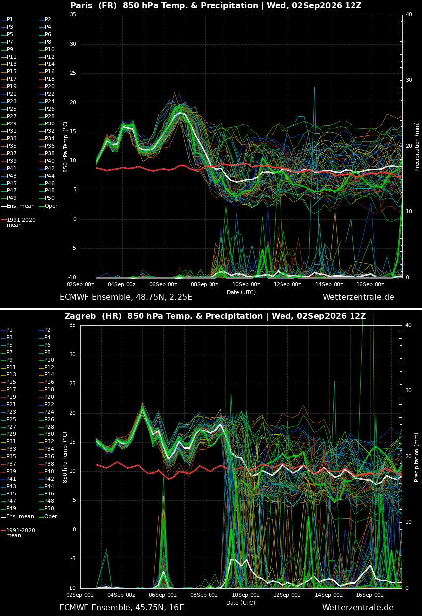
The heatwave reaches its broad continental peak early next week, blanketing countries from Portugal to the Balkans in stifling heat. However, medium-range ensemble models indicate a significant shift on the horizon. By mid-to-late next week, an upper-level ridge building in the North Atlantic is projected to guide a deep, cold-air mass intrusion into Western Europe. This impending dynamic shift promises to dismantle the heat dome entirely, paving the way for a much-needed pattern flip characterized by cooler maritime air, widespread rainfall, and the potential for severe weather outbreaks as the heavy summer heat discharges.
Supporting Data: Regional Temperature Breakdowns
Meteorological agencies utilizing data from global forecasting models—such as those provided by PivotalWeather and WXcharts—have broken down the regional impacts across the continent:
- Southwestern Europe (Spain & Portugal): Peak daytime highs between Thursday and Friday reached 40–44°C in central and southern regions. Northeastern Spain and inland Portugal maintained upper-30s to 40°C readings, a trend forecast to hold steady through the weekend before gradually easing.
- Western Europe (France & Benelux): Southern and central France experienced a severe return of high heat, with interior southern valleys nearing the 40°C mark. Central France hovered comfortably in the mid-30s, while northern France and the Benelux countries enjoyed milder, albeit warm, upper-20s.
- The British Isles: Spared the extreme continental temperatures, the UK nevertheless experienced a warm spell through Sunday. South-central England and Wales saw daytime highs push into the mid-to-upper 27s, while Ireland and Scotland remained capped in the low 20s.
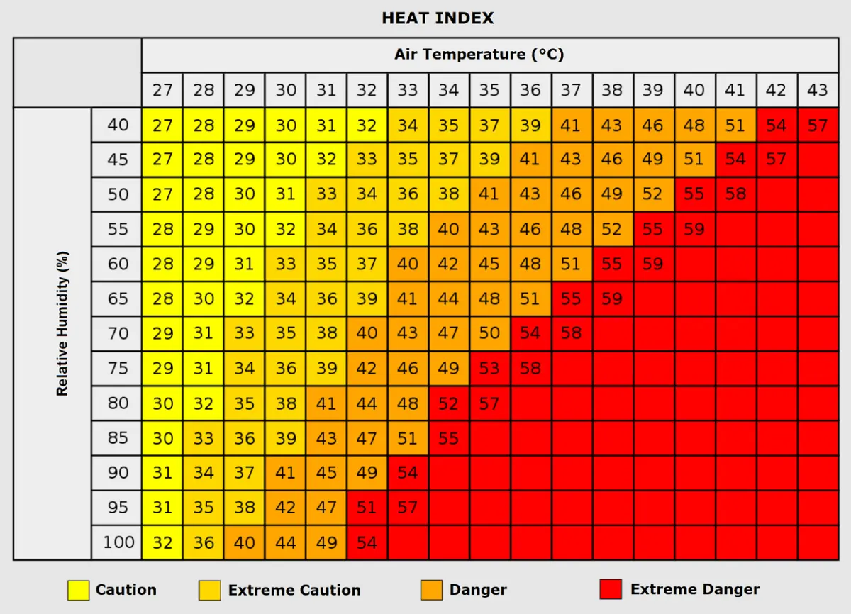
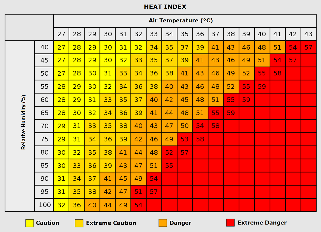
- Southern Europe & The Balkans: Italy and the central Balkans faced severe thermal stress from Friday onward. The Po Valley and Tuscany hit 38–41°C, while countries across the central Balkans hovered in the mid-to-upper 30s, accompanied by high relative humidity that pushed Heat Index values even higher.
Official Responses and Public Health Implications
The physiological and societal toll of a September heatwave of this magnitude cannot be overstated. Public health authorities and emergency management agencies across the affected nations have issued widespread heat advisories, emphasizing that late-season heat events often catch populations off guard.
Vulnerable Populations and Health Risks
Prolonged exposure to extreme heat, compounded by high relative humidity, severely elevates the risk of heat exhaustion, dehydration, and life-threatening heat stroke.
- Outdoor Workers: Construction workers, agricultural laborers, and maintenance crews face dangerous working conditions, requiring mandatory hydration breaks and adjusted shift hours.
- Urban Inhabitants: Lower-income populations residing in densely built urban environments constructed of heat-trapping concrete, asphalt, and asbestos face disproportionately high mortality risks. Urban heat islands prevent effective nighttime cooling, keeping indoor temperatures dangerously elevated.
- Medical Vulnerabilities: Emergency medical services have reported surges in cardiovascular and respiratory distress calls. Medical experts note that consecutive nights where temperatures fail to drop below 24°C place immense strain on the human cardiovascular system, particularly among the elderly and individuals with pre-existing chronic conditions.
Energy Grid and Environmental Pressures
Beyond immediate human health concerns, the prolonged heat dome is placing severe strain on continental energy grids. Widespread reliance on air conditioning is driving electricity demand to mid-summer peaks at a time of year when power systems typically enter maintenance phases.
Concurrently, the combination of extreme surface heat, dry continental winds, and depleted soil moisture has significantly elevated regional wildfire risks. Forested and agricultural mountain slopes across Spain, southern France, Italy, and the Balkans remain under strict fire-weather surveillance as authorities urge extreme caution to prevent spark-ignited blazes.
Looking Ahead: Relief on the Horizon
As Europe navigates the height of this September heat dome, meteorologists are closely tracking the promised pattern change. The transition from a stubborn blocking high to a dynamic Atlantic trough next week offers the promise of cooler maritime air, sweeping rain showers, and a definitive end to the unseasonable heatwave.
Until that relief arrives, populations across Southern, Western, and Central Europe are advised to remain vigilant, heed local meteorological warnings, and take all necessary precautions to survive one of the most intense early-autumn heat events in recent memory.
