

Main Facts: A Rare Super El Niño Engine Drives Global Weather
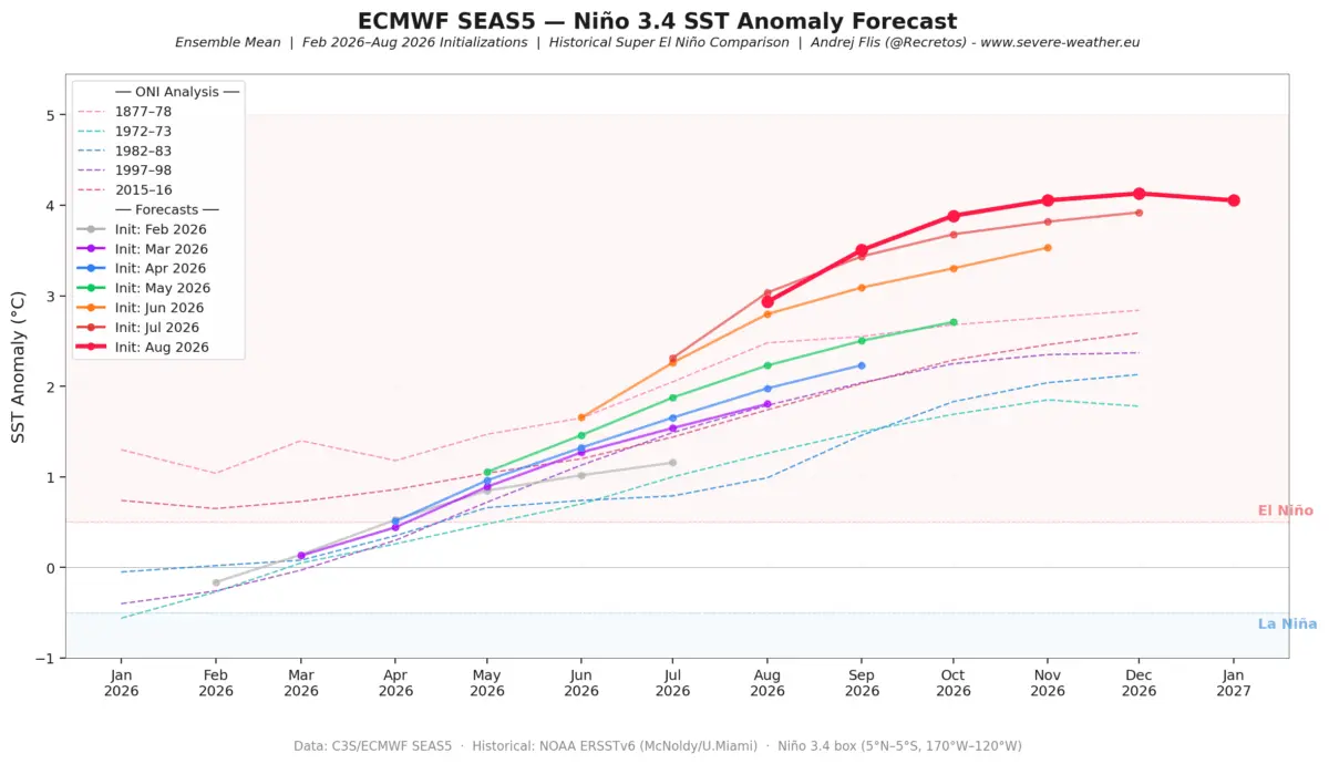
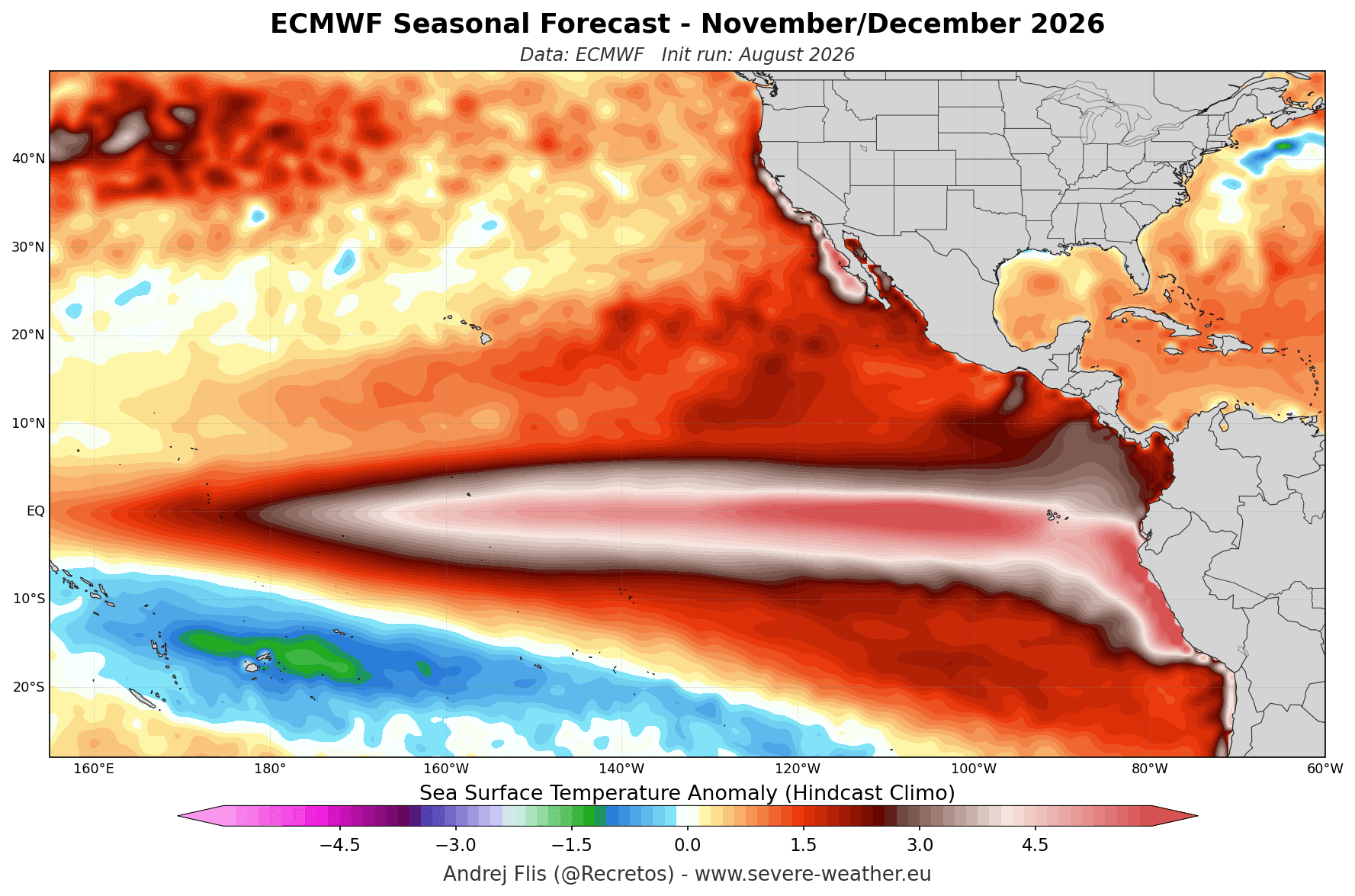
As the Northern Hemisphere transitions away from the warmth of autumn, long-range climate models are locking onto a singular, high-powered meteorological driver for the upcoming cold season: a developing Super El Niño. Global seasonal forecasting systems, including the European Centre for Medium-Range Weather Forecasts (ECMWF) and the National Centers for Environmental Prediction (NCEP), indicate that ocean heat anomalies in the tropical Pacific are tracking well into record-shattering territory.

This rare atmospheric and oceanic phenomenon is set to orchestrate a dramatic split-flow jet stream pattern across North America, profoundly altering temperature, precipitation, and snowfall distributions across the United States, Canada, and Europe.
Key Takeaways of the Winter 2026/2027 Outlook:
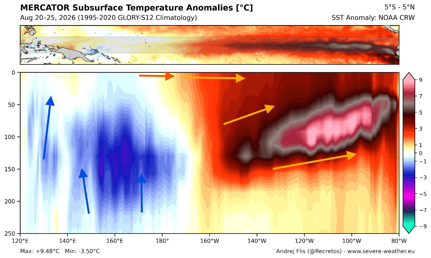
- Historic Oceanic Forcing: Subsurface ocean temperatures in the equatorial Pacific have spawned a powerful downwelling Kelvin wave, with anomalies exceeding 9°C (16°F) above normal.
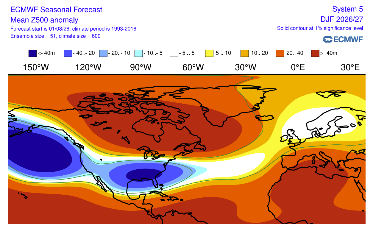
- North American Split-Flow: A classic El Niño response will establish a deep North Pacific low-pressure trough, a formidable blocking high-pressure ridge over Canada, and an active southern storm track across the United States.
- Temperature Extremes: Well-above-average temperatures are favored across Canada and the northern United States, while cooler, cloudier conditions will define the southern U.S. and Gulf Coast.
- Snowfall Realignments: Ski resorts in California’s Sierra Nevada and the Southern Rockies stand to benefit from frequent southern storms, whereas the Pacific Northwest and parts of the Northeast face potential snow deficits.
- Stratospheric Interplay: Early signals point toward a mid-winter weakening of the stratospheric Polar Vortex, which could introduce volatile, dynamic cold outbreaks as the season deepens.
Chronology: The Evolution Toward a Record Event
The roadmap to Winter 2026/2027 has been written over many months through continuous oceanic accumulation and atmospheric teleconnections. Understanding how this event materialized requires looking back at the progression of ocean-atmosphere dynamics.
Spring and Summer 2026: The Subsurface Buildup
The foundation for the current Super El Niño was laid early in the year as persistent westerly wind bursts across the equatorial Pacific began displacing warm upper-ocean waters eastward. This process initiated a massive downwelling Kelvin wave, pushing a thick core of super-heated water beneath the surface down to depths of 250 meters (800 feet).
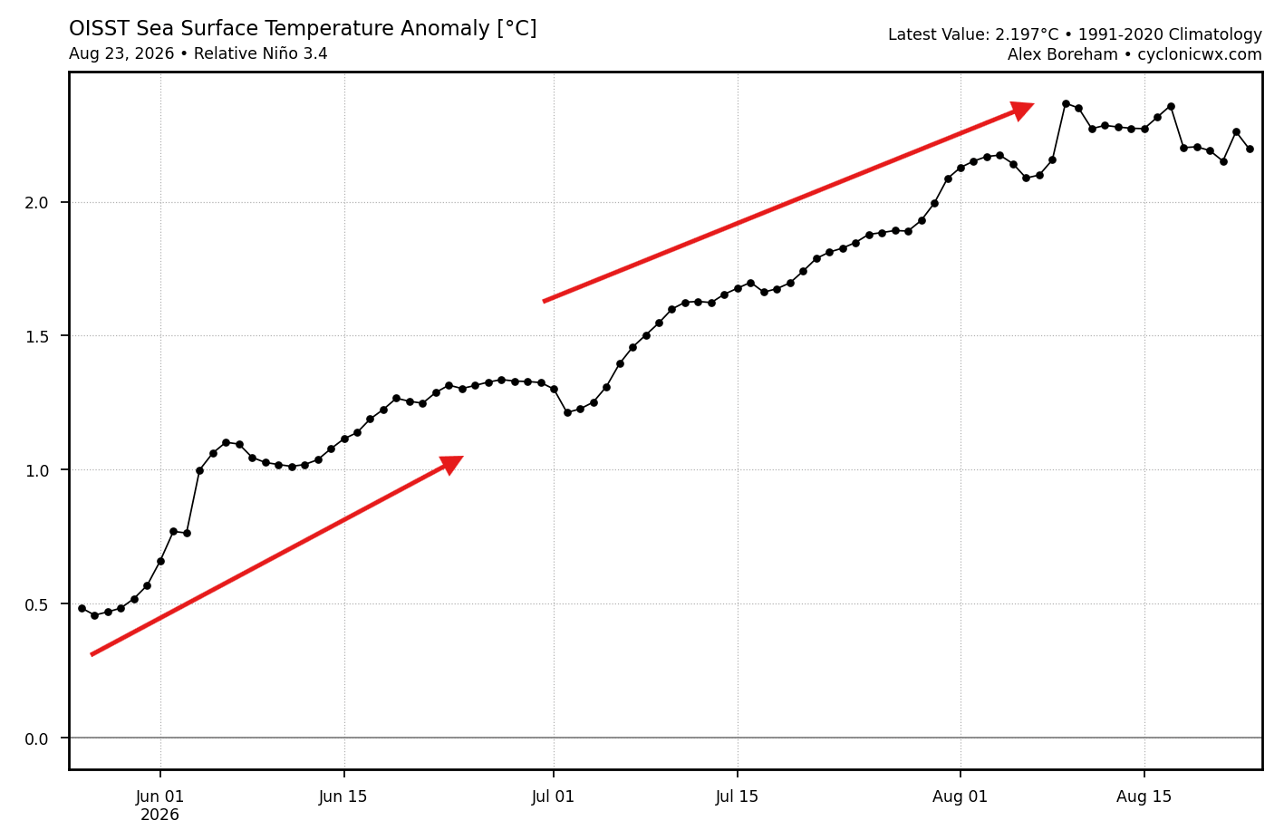
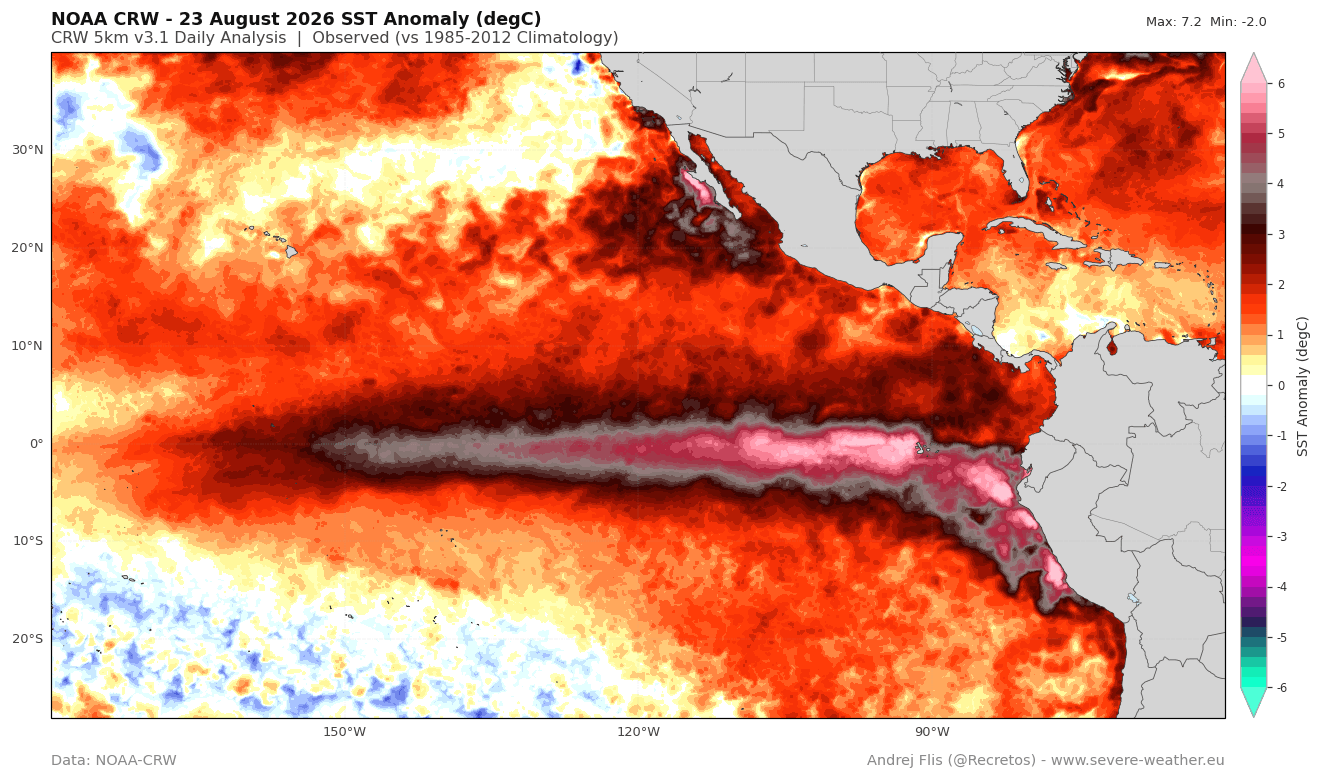
By late summer, NOAA Coral Reef Watch (CRW) data confirmed that sea surface temperature anomalies in the key Niño 3.4 region had comfortably surged past the +2°C threshold required for an El Niño classification, rapidly scaling into "Super" category criteria with localized anomalies exceeding +6°C (11°F).
Fall 2026: Model Convergence and Peak Strength
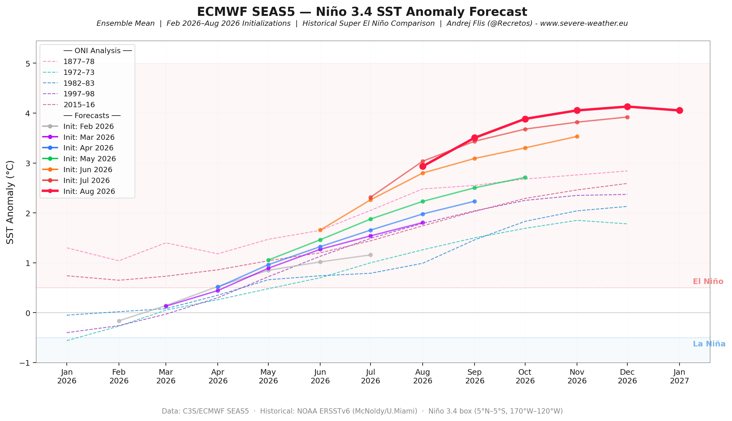
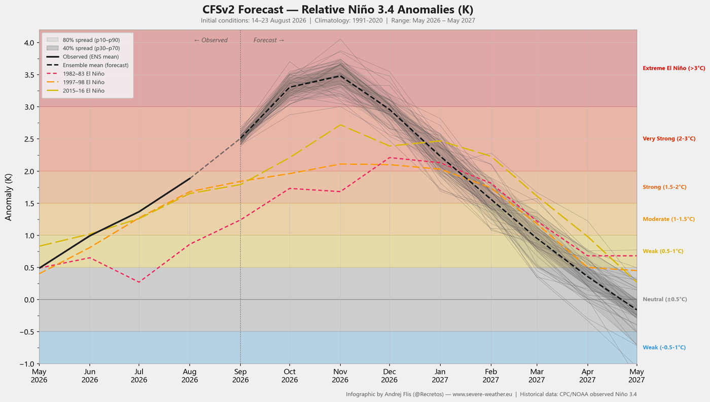
As autumn progressed, numerical weather prediction models began registering unprecedented consistency. With each consecutive monthly run, the ECMWF and NOAA’s CFSv2 models aggressively upgraded the peak strength projection for late autumn and early winter. This continuous upward trend placed the 2026 event on par with, or potentially exceeding, the historic Super El Niño events of the past.
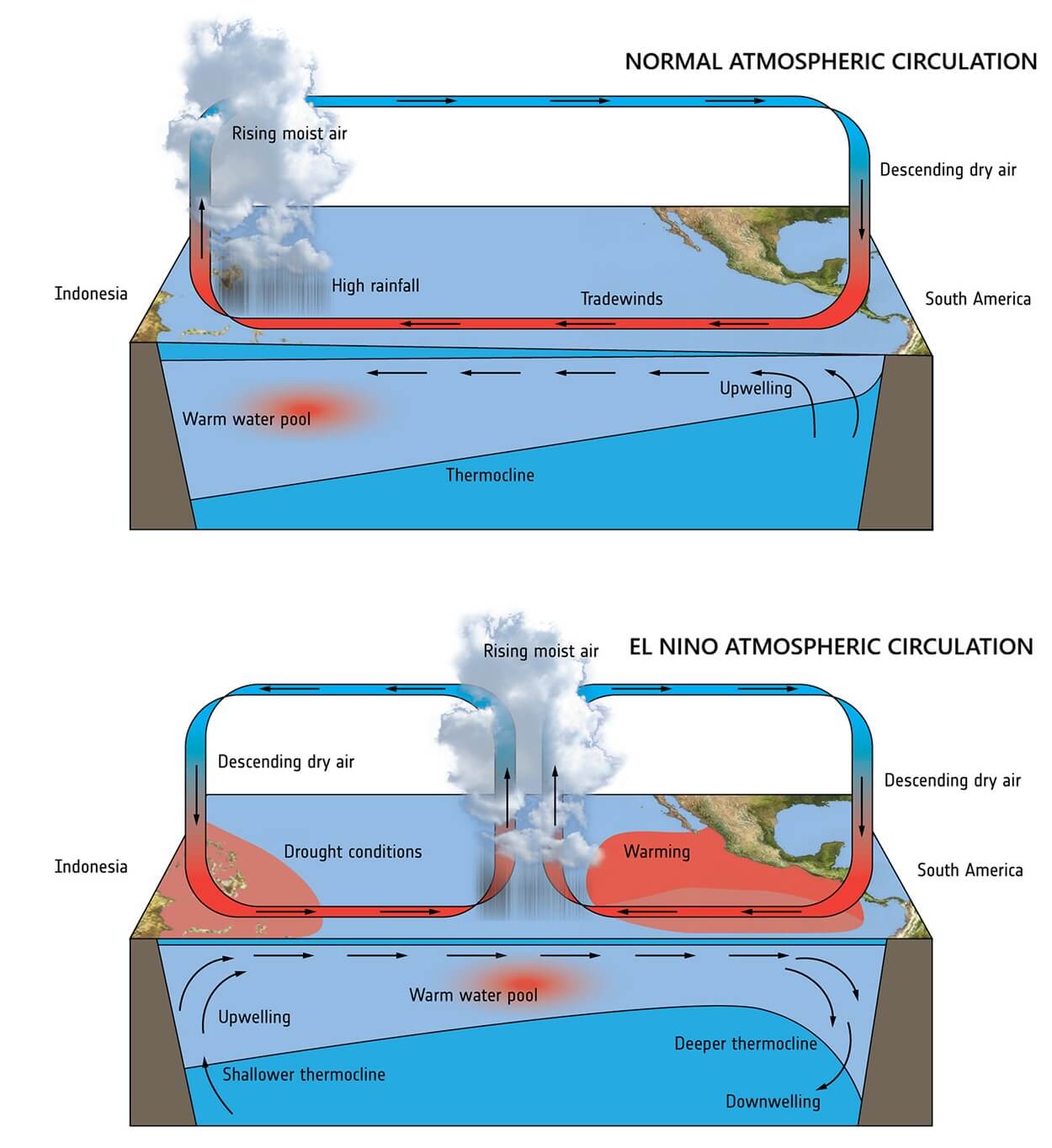
Concurrently, the Walker Circulation—the tropical loop of atmospheric upward and downward motion—shifted its centers of action. Low pressure deepened across the central and eastern tropical Pacific while high pressure built over the western basin, launching planetary-scale Rossby wave trains into both hemispheres.
Supporting Data: Dissecting Past Analogs and Modern Models
To translate ocean temperatures into actionable winter weather forecasts, meteorologists rely on historical analogs from past Super El Niño winters and cutting-edge ensemble simulations.
Lessons from Past Super Events
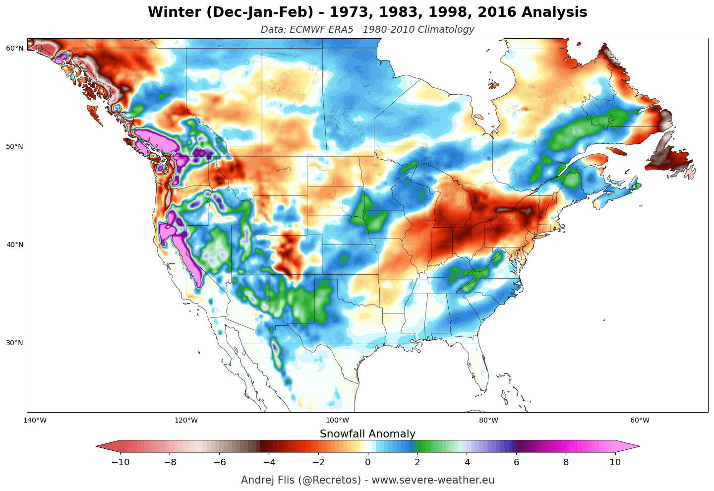
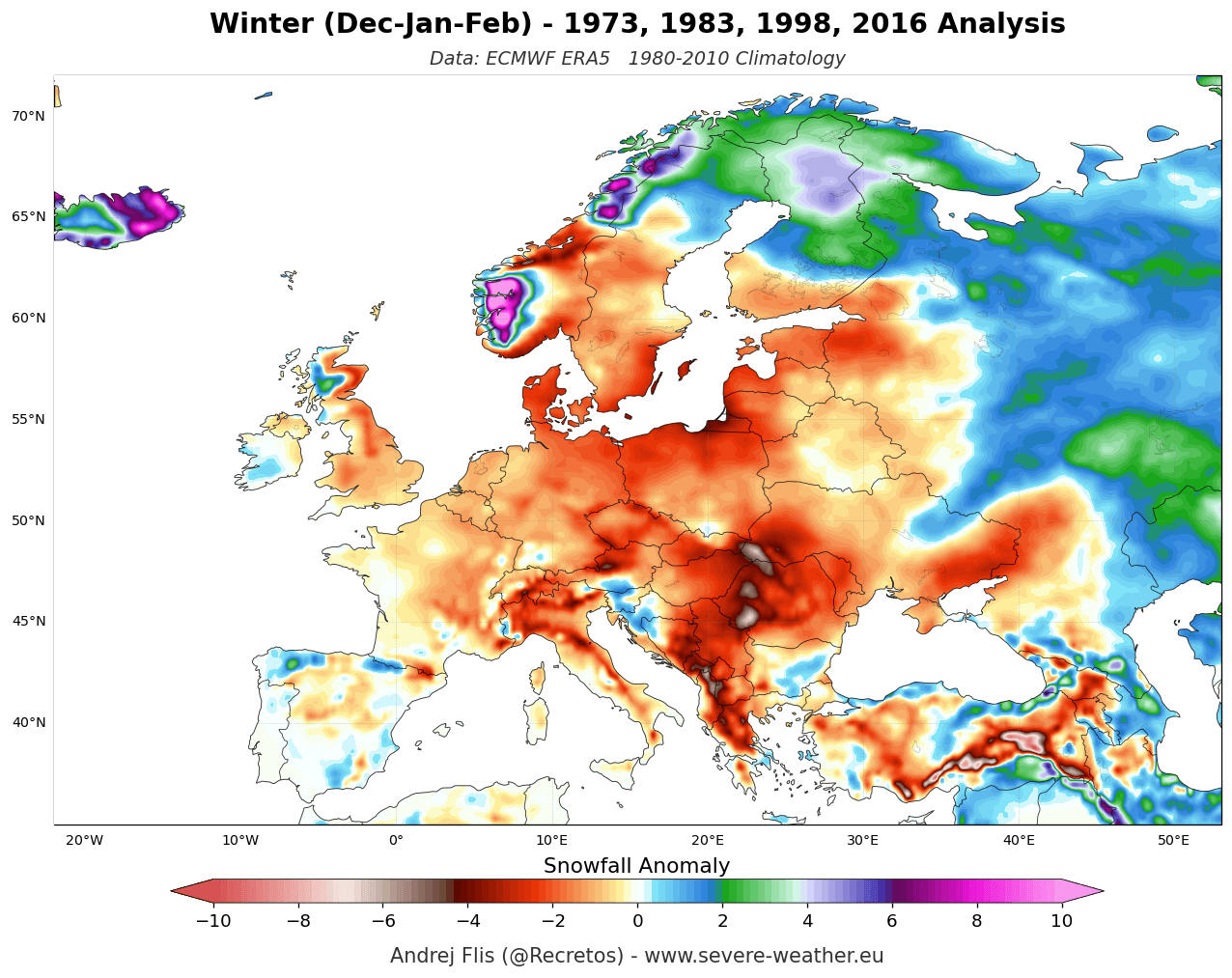
Historical reanalysis data (ERA5) from the last four major Super El Niño winters reveals a remarkably consistent atmospheric fingerprint. The primary feature across these seasons is a deepened Aleutian Low over the North Pacific, which forces a sprawling high-pressure ridge to anchor itself across western and central Canada.
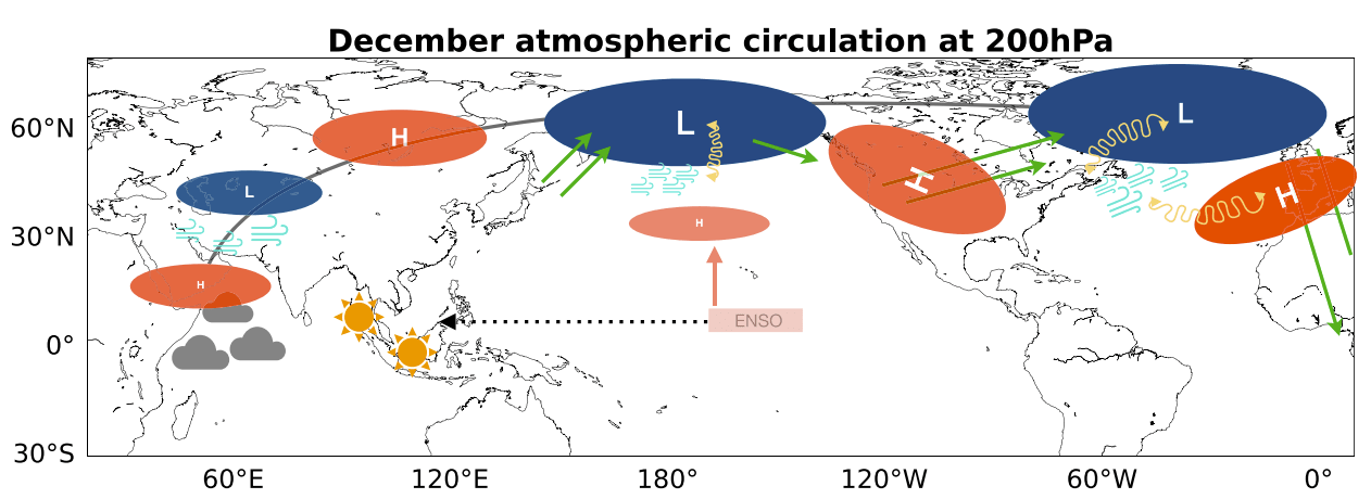
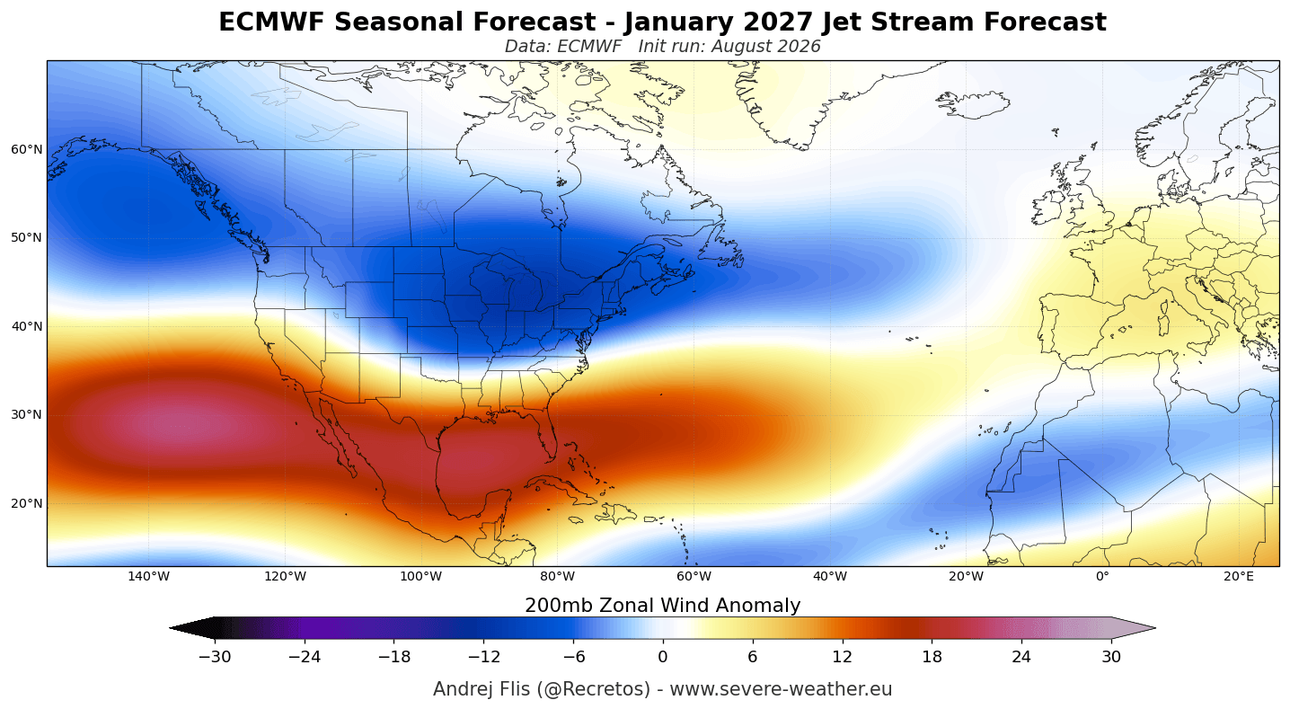
This pressure setup acts as an atmospheric roadblock, splitting the jet stream:
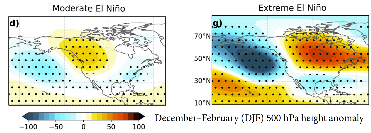
- The Northern Branch: Diverted far to the north, keeping the core arctic air locked away from the northern tier of the United States and southern Canada, leading to pronounced temperature surpluses.
- The Southern Branch (Subtropical Jet): Accelerated across the southern United States, serving as an active, moisture-laden corridor for low-pressure systems.
The ECMWF and NMME Consensus
For Winter 2026/2027, the ECMWF seasonal outlook for December through February projects a textbook Super El Niño response. A robust blocking high over Canada pairs with a dynamic low-pressure anomaly stretching from the southern United States into the North Atlantic.
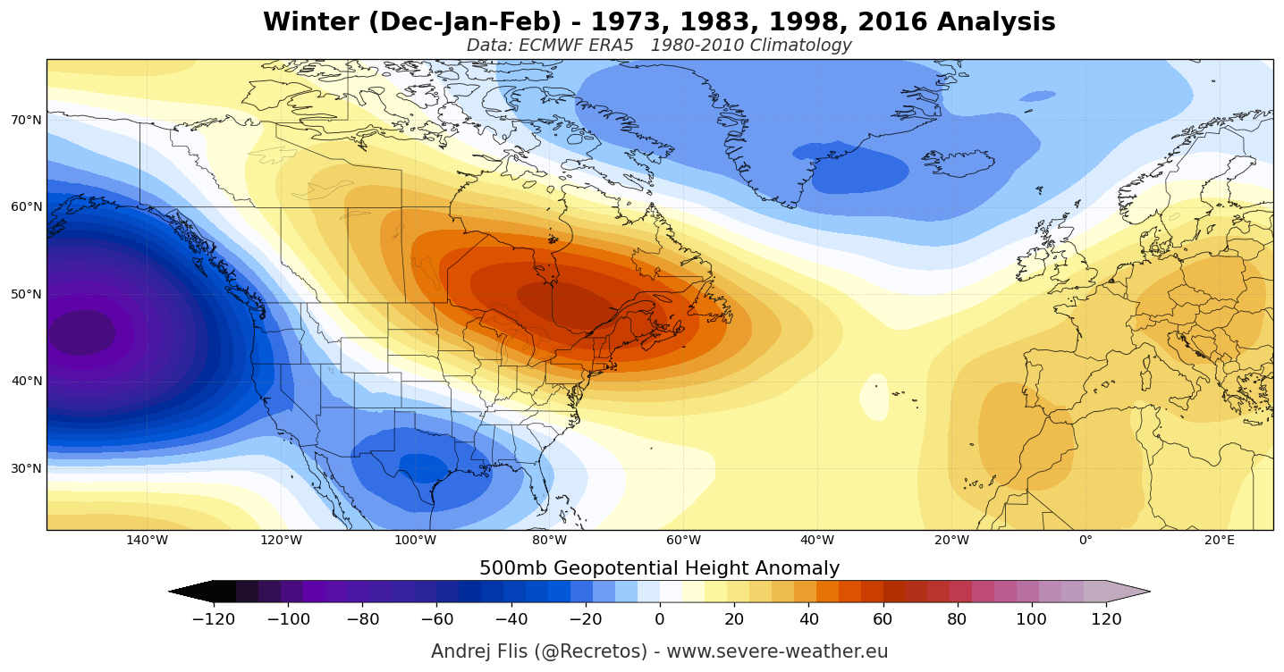
This multi-model consensus is corroborated by the North American Multi-Model Ensemble (NMME), which merges predictions from various U.S. and Canadian agencies. Both independent modeling suites show high agreement regarding temperature and precipitation anomalies, granting forecasters exceptionally high confidence in the large-scale macro structure of the upcoming season.
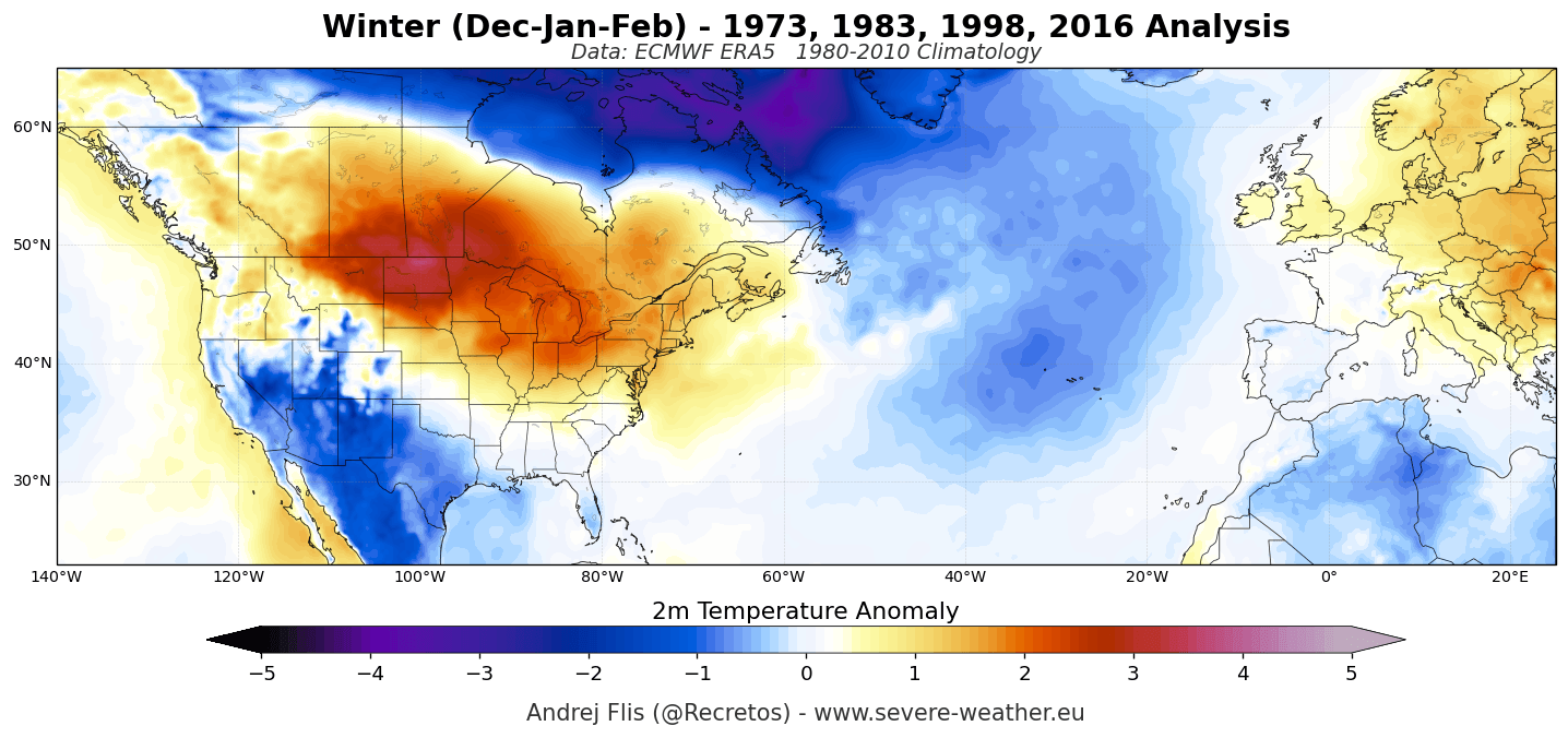
Official Responses and Expert Observations: The Polar Vortex Factor
While the tropical Pacific dictates the baseline seasonal trends, atmospheric scientists emphasize that the stratosphere plays a critical role in modulating mid-winter volatility. Specifically, the stratospheric Polar Vortex—the swirling vortex of high-altitude winds trapping cold polar air—is exhibiting early signals of disruption.
Mid-Winter Deceleration Signals
Recent stratospheric forecasts from both the ECMWF and the UK Meteorological Office (UKMO) show an unusual deceleration of zonal winds at the 10 hPa level (approx. 30 km altitude) slated for late December and January.
While seasonal models cannot predict precise Sudden Stratospheric Warming (SSW) events months in advance, an early-season slowdown suggests that the massive wave energy pumped upward by the Super El Niño is successfully putting stress on the vortex.
[Super El Niño Pacific Forcing]
          │
          ▼ (Upward Planetary Wave Energy)
[Stratospheric Polar Vortex Deceleration (Late Dec / Jan)]
          │
          ▼ (Potential Dynamic Disruption)
[Mid-to-Late Winter Jet Stream Meanders & Cold Outbreaks]
According to historical composites, a weakened or disrupted Polar Vortex in a Super El Niño year can introduce wild card shifts in January and February. Although the overall baseline remains warm in the north and wet in the south, a fractured vortex can occasionally dislodge bitter arctic air masses southward into the mid-latitudes, creating sharp, high-impact regional weather shocks.
Implications: Regional Impacts Across North America and Europe
The structural peculiarities of the Winter 2026/2027 forecast carry profound implications for regional weather, energy consumption, winter sports economies, and hydrology.
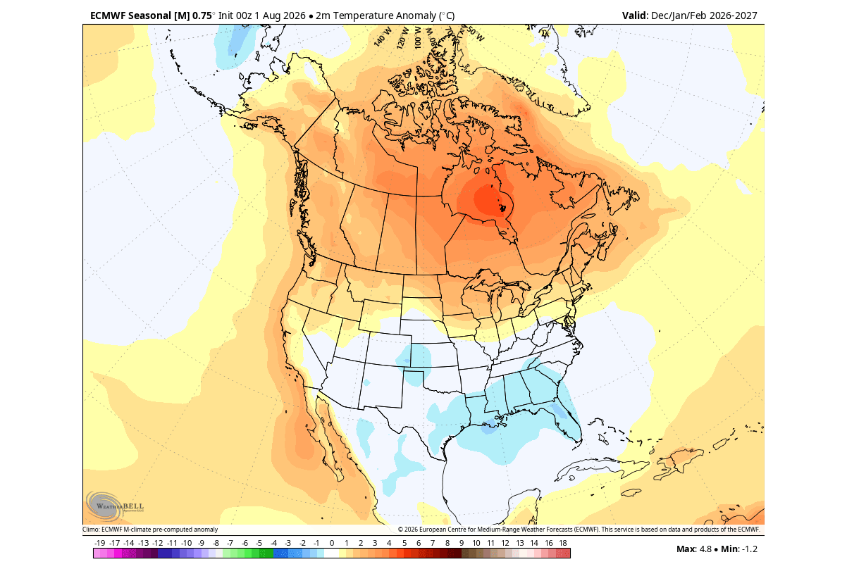
United States and Canada: The North-South Divide
- The North and West: Canada, the Upper Midwest, the Northern Plains, and parts of the Pacific Northwest face a mild, dry winter. Snowpack accumulation in these regions is projected to lag behind historical averages, presenting challenges for regional ski resorts and winter tourism.
- The South and East: Conversely, the southern tier of the United States—from Texas across the Gulf Coast and into the Southeast—will experience a wet, unsettled, and cooler-than-normal winter. Persistent cloud cover and frequent storm passages driven by the active subtropical jet will elevate precipitation totals.
- The Snowfall Story: Skiers and winter enthusiasts targeting the American West will find optimal conditions centered over California’s Sierra Nevada, Utah, and the Central-to-Southern Rockies (Colorado, Arizona, New Mexico), where southern moisture feeds abundant snowfall. Meanwhile, the Northeast and Great Lakes face a mixed bag, heavily dependent on the exact timing of coastal storm tracks interacting with brief cold air intrusions.
Europe: Atlantic Dominance and Elevation Dependency
Over Europe, the Super El Niño signature manifests as a dominant, mild westerly and southwesterly flow originating from the North Atlantic.
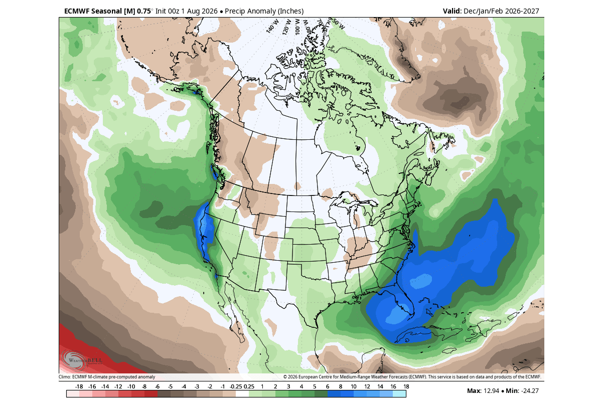
- Temperature and Moisture: Most of the continent is favored to record above-average seasonal temperatures. Precipitation anomalies will tilt positive across western, central, and northern Europe as frequent Atlantic low-pressure systems sweep inland.
- The European Ski Outlook: Lowland and mid-elevation ski resorts (such as the Pyrenees, Apennines, and Balkans) face a difficult snowpack setup due to persistent mild maritime air. However, high-elevation resorts in the central and western Alps (altitudes above 1,800 to 2,000 meters) remain well-positioned to capitalize on moisture-rich systems, provided temperatures at those altitudes remain sufficiently low.
Outlook Summary
Winter 2026/2027 is shaping up to be a textbook demonstration of tropical-extratropical teleconnections. Driven by an intensifying, historic Super El Niño and modulated by potential mid-winter stratospheric adjustments, the coming season promises stark regional contrasts: warmth and dry conditions across Canada and the northern U.S., contrasted with storminess, heavy southern moisture, and high-altitude mountain snows. Meteorologists and regional stakeholders alike will closely monitor the evolving Polar Vortex signals as December approaches to fine-tune short-range expectations against this powerful macro-scale baseline.
