

GLOBAL METEOROLOGICAL REVIEW — Every autumn, as temperatures drop across the Northern Hemisphere, a familiar ritual plays out across weather forums and social media channels. Meteorologists, climate hobbyists, and winter enthusiasts alike cast their eyes eastward toward Siberia, asking a single, high-stakes question: Is snow spreading fast across the Eurasian landmass?
For well over a decade, conventional meteorological lore has held that a rapid October snow advance in Siberia serves as an infallible early warning sign for a harsh, bitterly cold, and snow-packed winter across the United States, Canada, and Europe. Popularized by a landmark 2011 scientific study, this "Siberian Snow Advance Theory" has been regurgitated year after year as the holy grail of long-range winter forecasting.
However, a comprehensive new empirical investigation analyzing 47 winters of data spanning from 1979 to 2025—utilizing four independent snow datasets, including the exact satellite metrics used in the original research—upends conventional wisdom. The results are striking: the famous snow signal has largely broken down, performing no better than a coin flip over the past decade and a half. As the meteorological community looks ahead to the unfolding winter of 2026/2027, experts warn that we must look far beyond Siberian snowfields to understand what lies ahead.
Main Facts: The Anatomy of a Long-Range Forecasting Theory
The persistent belief in the Siberian snow signal rests on a theoretically sound, elegant physical mechanism linking surface conditions to the stratosphere.
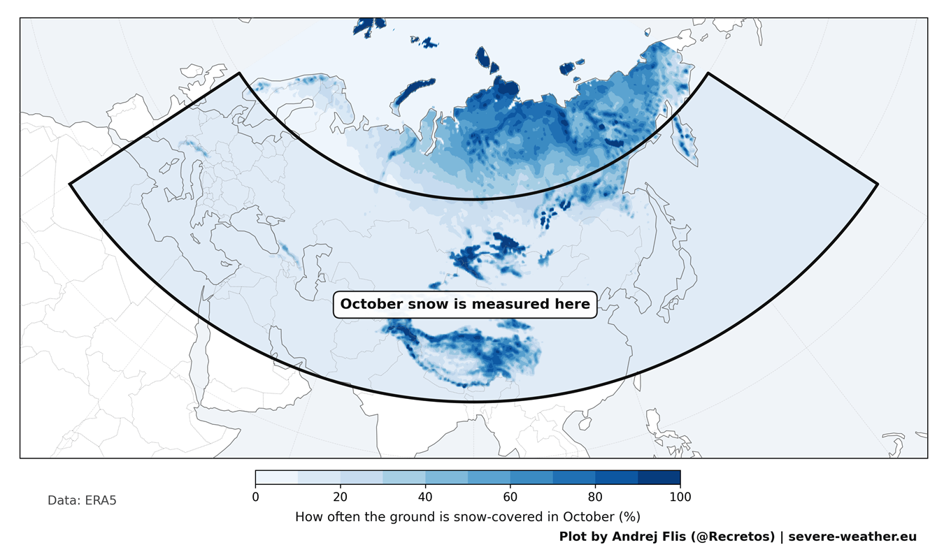
In 2011, climate scientists Judah Cohen and Justin Jones identified a compelling statistical link: the faster snow cover expands across Eurasia during October, the higher the probability that the mid-latitudes of North America and Europe will experience severe Arctic cold air outbreaks later in the winter season.
The Chain Reaction of the Atmosphere
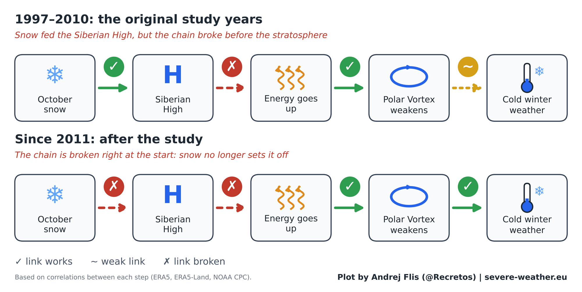
The physical theory operates through a multi-step atmospheric chain reaction:
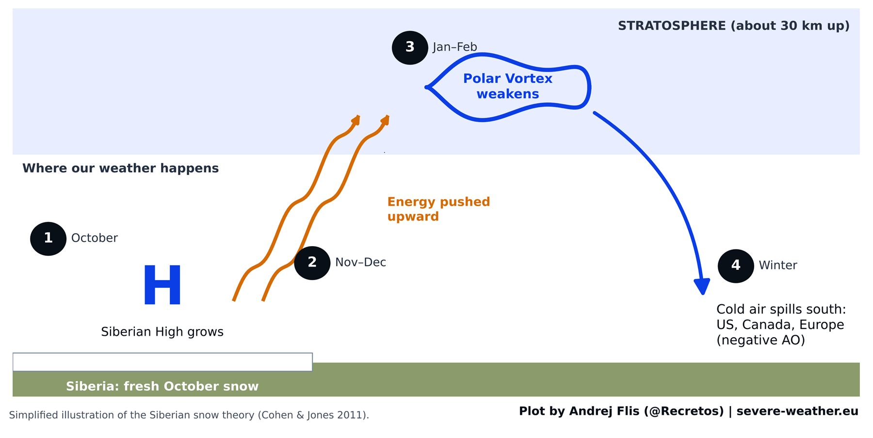
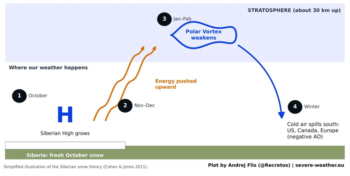
- Surface Cooling: Fresh, pristine snow cover dramatically cools the underlying ground.
- Pressure Building: This intense surface cooling strengthens the Siberian High—a sprawling, semi-permanent area of dense, cold air centered over northern Asia.
- Stratospheric Wave Energy: The strengthened Siberian High acts as a springboard, reflecting planetary-scale wave energy upward into the stratosphere, roughly 30 kilometers (18.5 miles) above the Earth’s surface.
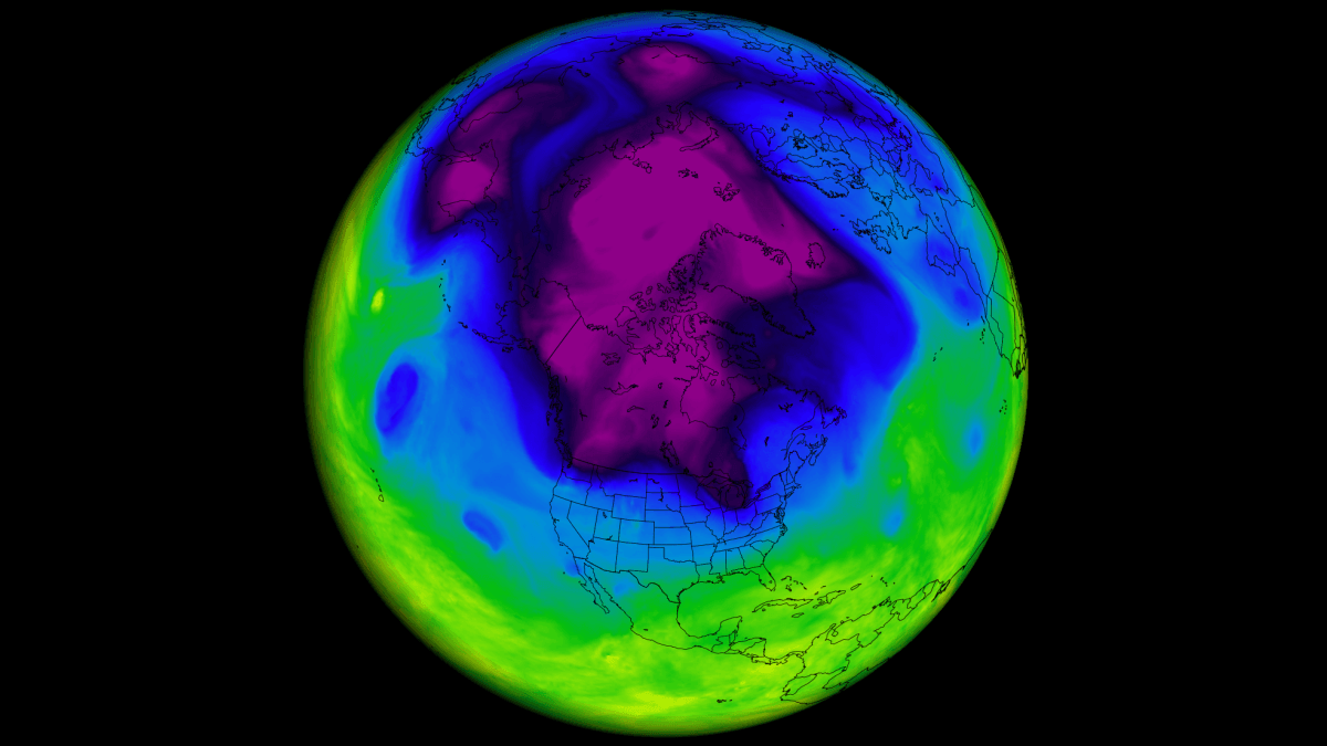
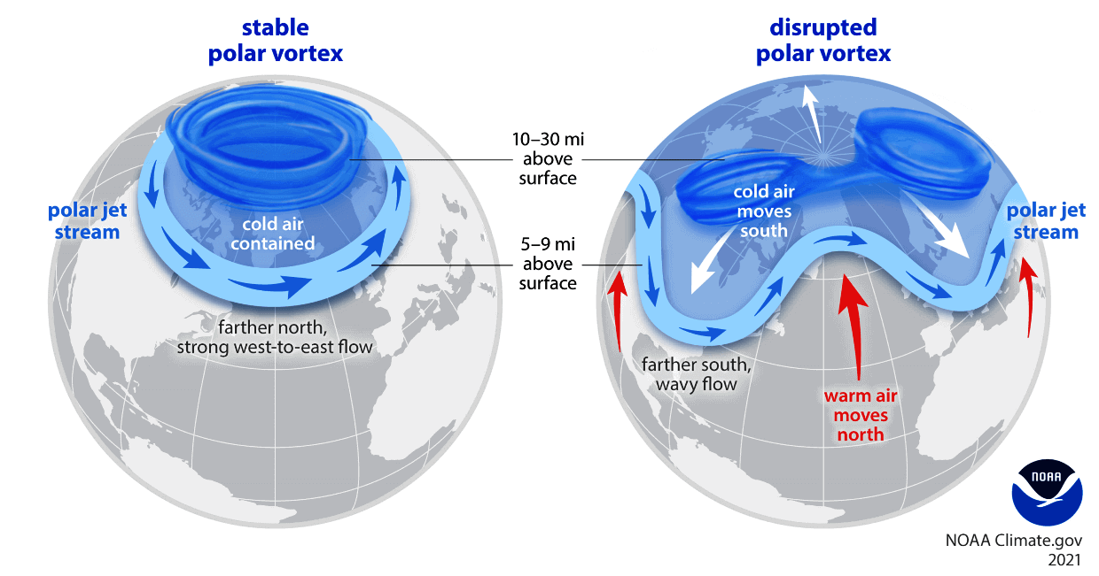
- Polar Vortex Disruption: This upward surge of energy destabilizes the stratospheric Polar Vortex—a massive ring of fast-moving westerly winds that normally bottles up the core of the Arctic freeze.
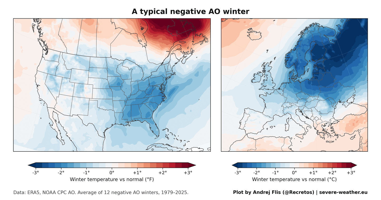
- The Arctic Oscillation (AO) Shift: When the Polar Vortex is disrupted, stretched, or collapses entirely, it enters a negative Arctic Oscillation (AO) phase. This allows lobes of frigid air to break away and plunge southward into the eastern United States, northern Europe, and parts of Canada.
While this mechanism satisfies the laws of atmospheric physics, real-world data collection tells a far more nuanced story about its practical predictive power.
Chronology: The Rise, Fall, and Evolution of the Snow Signal
The Genesis (1997–2010)
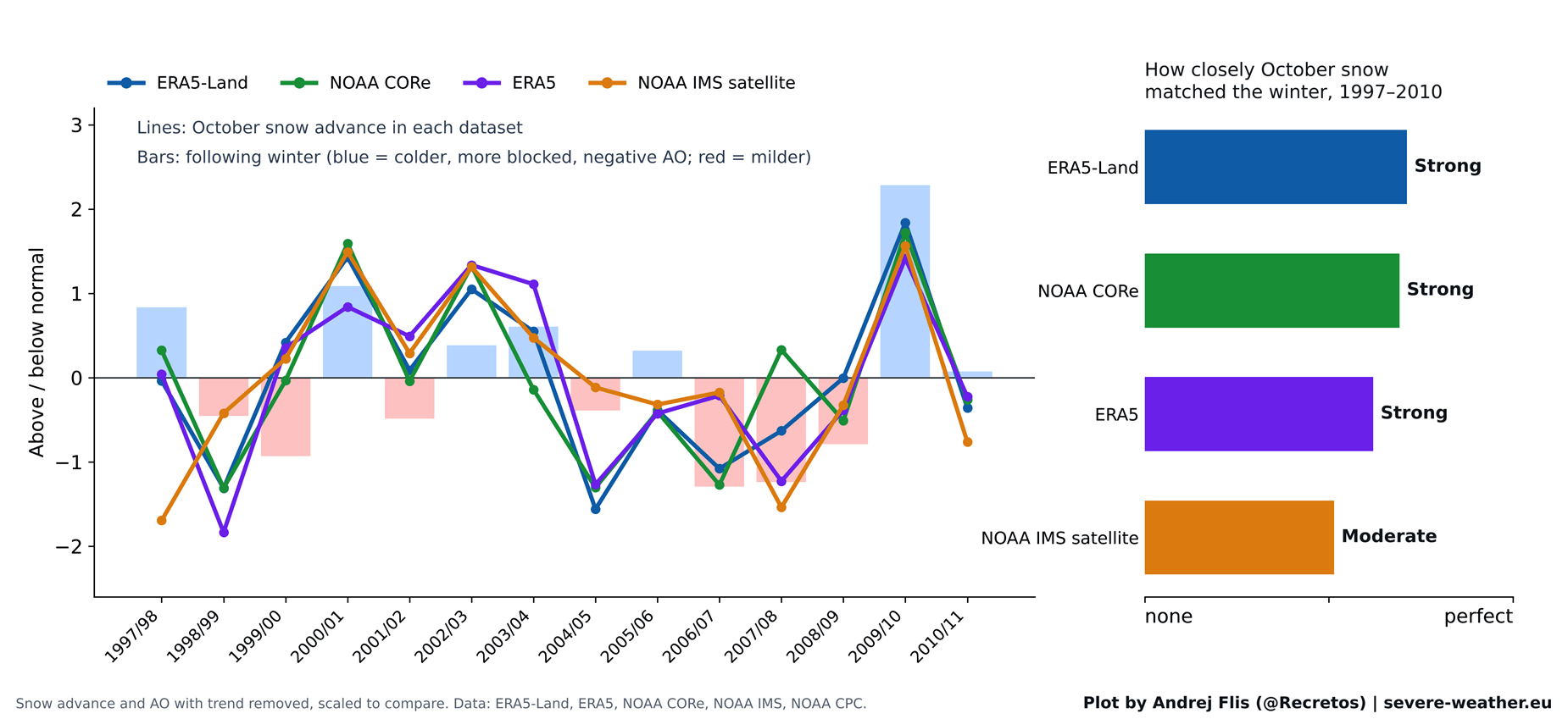
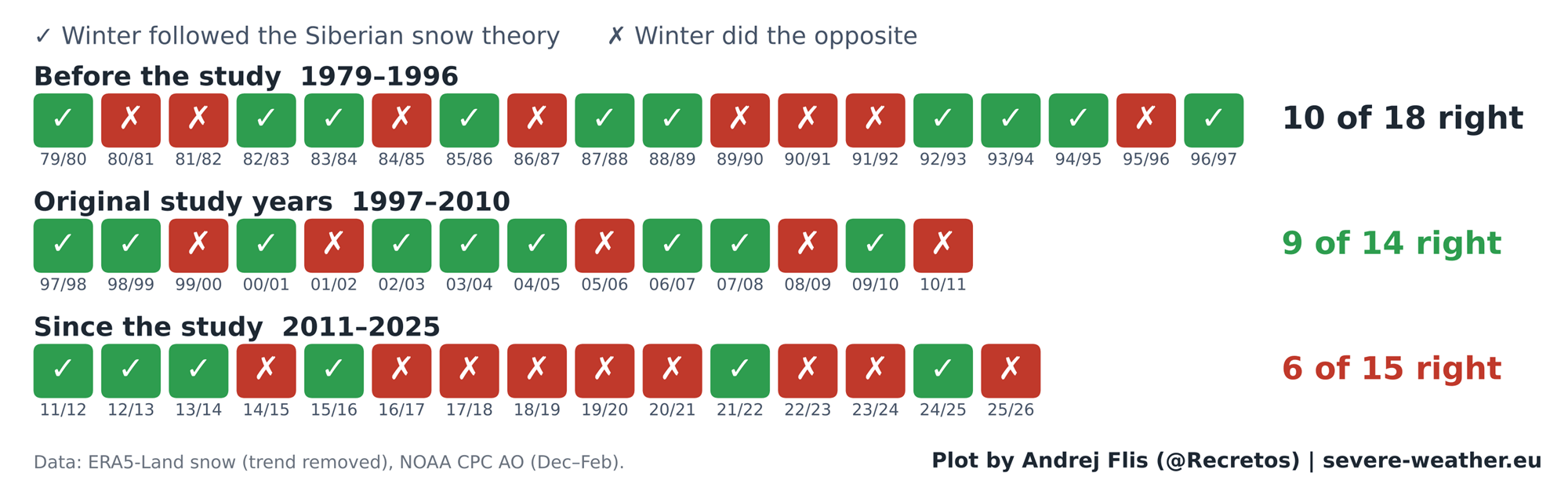
When Cohen and Jones published their groundbreaking study in 2011, daily satellite snow maps only extended reliably back to 1997. Consequently, the original researchers based their findings on a relatively compact baseline of 14 winters.
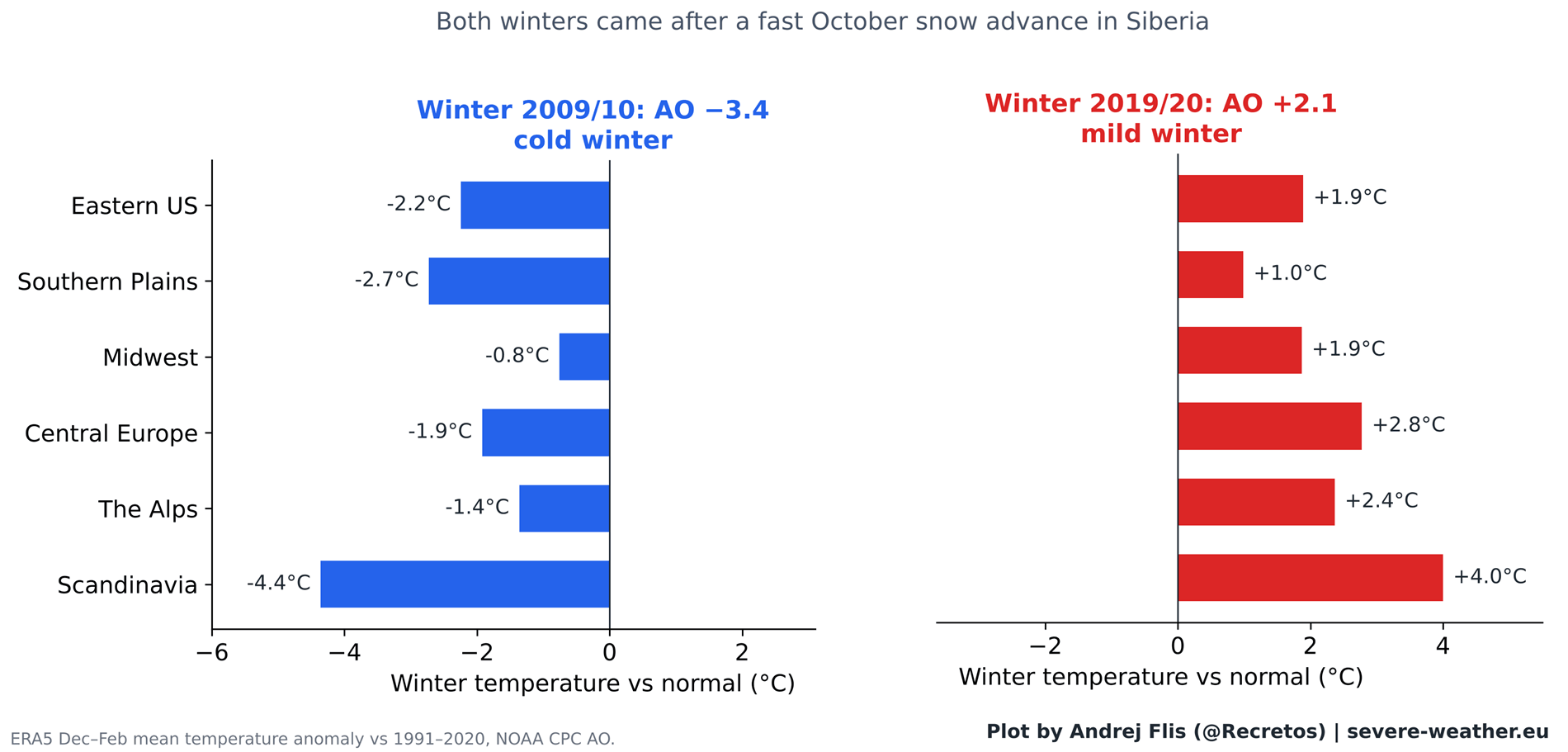
During this specific timeframe, the correlation was remarkably tight. The theory achieved a success rate of 9 out of 14 winters, fueled heavily by standout extreme seasons like the winter of 2009/2010. That particular year followed a blistering October snow advance and culminated in a deeply negative AO, delivering historic, paralyzing blizzards to the Mid-Atlantic and Eastern United States in February 2010. This high-profile success cemented the theory in the public consciousness.
The Decadal Fade (2011–Present)
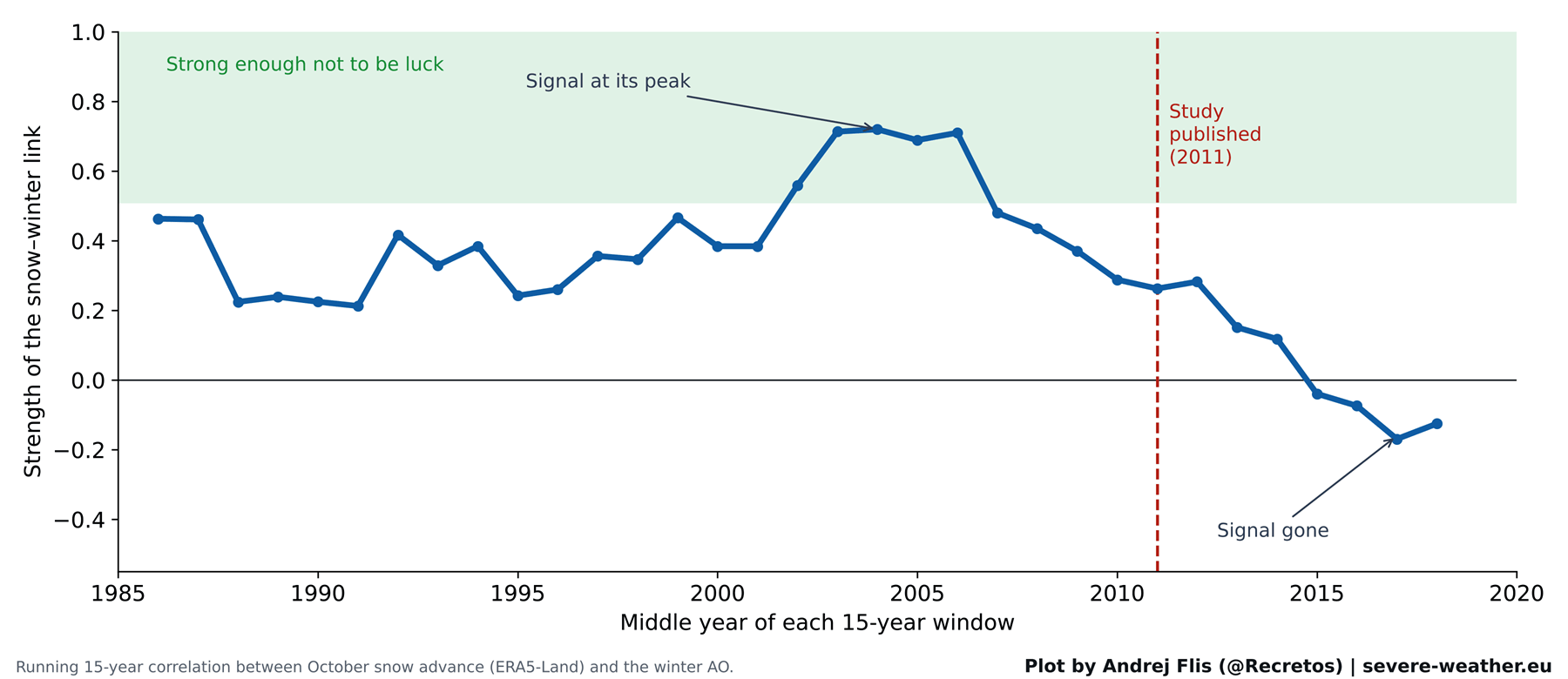
Armed with 15 additional years of data since the study’s publication—bringing the total dataset to 47 winters—modern researchers have put the hypothesis through the ultimate scientific trial: testing it against out-of-sample years.
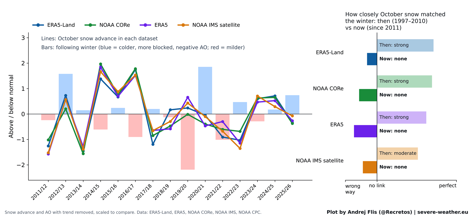
When evaluating performance across all four independent snow datasets, the results show a distinct trend line. The predictive strength peaked sharply in the mid-2000s, right around the time the theory was formulated. Since 2011, however, the statistical signal has systematically evaporated.
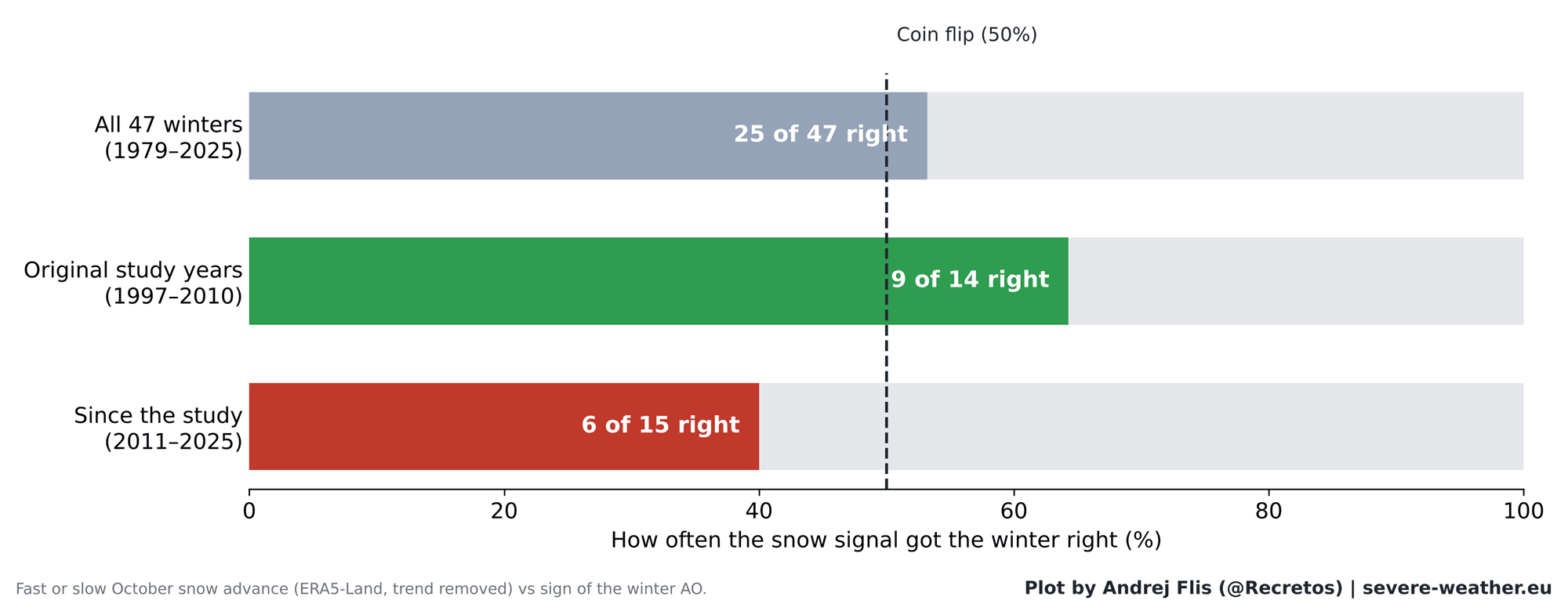
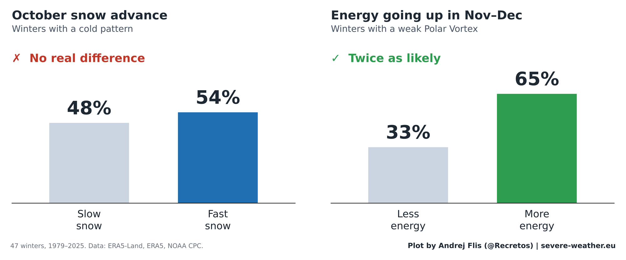
Over all 47 winters analyzed in the updated study, the October snow signal successfully predicted the correct winter AO outcome 25 times and failed 22 times—essentially a 53% success rate, or a statistical coin flip. Worse still, looking exclusively at the 15 winters since 2011, the signal was right only 6 times, performing worse than random chance.
Most notably, winter 2019/2020 completely inverted the theory: despite a rapid October snow advance, it produced one of the strongest positive AO phases on record, bringing exceptionally mild, snow-starved conditions to both Europe and the United States.
Supporting Data: Testing the Chain Reaction and Regional Impacts
To diagnose why the theory faltered, researchers examined each link in the atmospheric chain reaction independently.
Where the Chain Breaks
The later stages of the atmospheric machinery remain rock-solid: when excess energy successfully propagates into the stratosphere in November and December, the Polar Vortex does consistently weaken in January and February, reliably driving winter weather anomalies.
The breakdown occurs at the very beginning of the sequence. While October snow historically linked to a stronger Siberian High, that surface-to-stratosphere bridge has fractured in the modern era. Modern multi-decadal data indicates that October snow cover no longer reliably forces the upward energy pulses required to disrupt the vortex.
Regional Verification Check
Expanding the analysis beyond the hemisphere-wide Arctic Oscillation, researchers evaluated temperature and precipitation outcomes across 11 distinct sub-regions in North America and Europe:
- The Past Era: During the 1997–2010 baseline, eastern U.S. winters showed clear cooling trends following rapid Eurasian snow advances, while precipitation anomalies aligned in Europe.
- The Modern Era: Since 2011, out of 44 regional checks, virtually all regional correlations have collapsed. Only Western Canada retains a faint statistical whisper of a long-term link, far too weak to guide operational forecasting.
Implications for Winter 2026/2027: Shifting Paradigms
As meteorologists analyze current telemetry for the upcoming winter season, the focus has pivoted away from Siberian snow metrics toward far more dominant climatic drivers.
The October 2026 Snow Outlook
Satellite observations and high-resolution ECMWF forecasts indicate a sluggish start to October 2026 Eurasian snow cover during the first week. However, forecast models project a sharp, late-month surge that could push cumulative October snow advance rates into the top 15% of the historical distribution.
Based on historical analogs featuring similarly front-loaded snow surges (such as 2002, 2019, and 2023), subsequent winter AO phases yielded mixed results: three negative, one neutral, and two positive winters. Consequently, modern meteorologists treat a rapid October snow advance as an interesting atmospheric footnote rather than a reliable oracle.
Enter the Super El Niño
For Winter 2026/2027, the heavy lifting of long-range forecasting belongs to a powerhouse oceanic anomaly: an active Super El Niño in the Pacific basin.
Current NOAA Coral Reef Watch data confirms historic sea-surface temperature anomalies across the equatorial Pacific. Extensive modeling demonstrates that a robust Super El Niño exerts a powerful, well-documented influence on the subtropical jet stream, storm tracks, and stratospheric wind dynamics.
According to recent ECMWF seasonal forecasts tracking zonal winds at the 10mb level high in the stratosphere, the Polar Vortex is projected to undergo significant deceleration starting in late December. This points toward an elevated risk of a Sudden Stratospheric Warming (SSW) event and a subsequent vortex collapse during mid-to-late winter 2027.
Regional Forecast Expectations for Early 2027
Because a Super El Niño modulates atmospheric pressure fields differently than isolated snow cover anomalies, the projected winter temperature anomalies look distinct:
- United States: ECMWF ensemble projections favor a classic Super El Niño signature for February 2027, featuring cooler-than-average temperature anomalies and active storm tracks across the southern, central, and eastern United States due to persistent cloud cover and precipitation, while northern tiers lean milder.
- Europe: Current medium-to-late winter trends point toward a predominantly milder maritime flow across Western and Central Europe, with true cold anomalies largely locked into far northern Scandinavian sectors.
A Technical Caveat: The Reanalysis Data Challenge
In the course of conducting this exhaustive 47-year data review, researchers uncovered a critical technical artifact relevant to climate scientists utilizing historical reanalysis archives.
Within the standard ERA5 dataset, Eurasian October snow cover exhibits an artificial, abrupt drop of approximately 40% occurring precisely in the year 2004. Comparative analysis against independent monitoring systems—including NOAA CORe, ERA5-Land, and raw IMS satellite products—proves this drop is an artifact tied to when ECMWF reanalysis protocols transitioned to incorporating automated satellite snow mapping, disproportionately affecting data collection in Siberian lowland forests between 50°N and 70°N. Fortunately, cross-verification with independent datasets confirms that while the data requires adjustment for trend analysis, the broader conclusions regarding the breakdown of the snow-vortex correlation remain entirely secure.
Summary and Outlook
The romance of tracking Siberian snow cover each October will undoubtedly persist across weather enthusiast communities. Yet, the empirical data from 47 years of observation delivers a sobering reality check: while the physical laws governing stratospheric wave dynamics remain absolute, the terrestrial snow bridge that once linked Siberian October weather to mid-latitude winter freezes has broken down.
As winter 2026/2027 approaches, forecasters will monitor late-autumn stratospheric heat fluxes and the titanic footprint of the ongoing Super El Niño—signals equipped with the genuine predictive muscle required to navigate the complexities of modern winter weather forecasting.
